It looks like you're using an Ad Blocker.
Please white-list or disable AboveTopSecret.com in your ad-blocking tool.
Thank you.
Some features of ATS will be disabled while you continue to use an ad-blocker.
share:
reply to post by rosswellian
You have a PM/U2U . . . that should have notified you by the envelope icon in the upper left turning white--if you are using the dark background.
You have a PM/U2U . . . that should have notified you by the envelope icon in the upper left turning white--if you are using the dark background.
reply to post by rosswellian
Agreed
&sbl=1
That was the root of all my problems so my apologies. I had overlooked that parameter. All working OK now for maps. Testing 3DV and HTML and will issue soon.
I have a lot to learn about interfacing with google Earth but I do understand some about interfacing with the online Google Maps API V3 interface. The complexities such as if you asked for "what would amount to one inch high by 7 inches wide, onscreen?" -- they seem to adjust to something they think is more manageable. Don't ask me, what they actually do is a mystery to most everyone...
Agreed
&sbl=1
That was the root of all my problems so my apologies. I had overlooked that parameter. All working OK now for maps. Testing 3DV and HTML and will issue soon.
edit on 21/10/2013 by PuterMan because: (no reason given)
A Beta version of the IEB Url Builder is now available if anyone would like to have a go at it.
You can download the zip file for the setup from here:- IEBUrlBrowser_1-0-0-1_setup.zip
It has to be a zip file to satisfy the T & C.
If you do not have unzipping facilities (really?) you can access the executable setup file from the IEB Url Builder post on DA Software.
Please let me know if you have any problems.
If you saw this post before I found the error and fixed it please download and install the program again. You don't need to uninstall it first.
edit on 21/10/2013 by PuterMan because: (no reason given)
reply to post by PuterMan
Fantastic, works great.
Well done.
I clicked all the boxes and each part, Map, 3D and Table opened in separate tabs.
Also one degree chunks of area are possible to exact decimal points.
Perfect.
Many thanks for your work.
Fantastic, works great.
Well done.
I clicked all the boxes and each part, Map, 3D and Table opened in separate tabs.
Also one degree chunks of area are possible to exact decimal points.
Perfect.
Many thanks for your work.
reply to post by PuterMan
Hey, Puterman, even I could do it.
Now to find some stray long lat's lying around to insert. LOLOL.
Great work. Thx.
Hey, Puterman, even I could do it.
Now to find some stray long lat's lying around to insert. LOLOL.
Great work. Thx.
Interesting observation about 3DV and the "coastline" option
Doesn't include Lakes
S -38.61, N -39.10
W 175.65, E 176.2
Lake Taupo
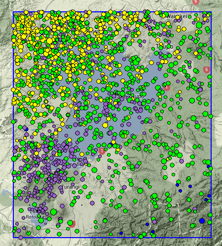
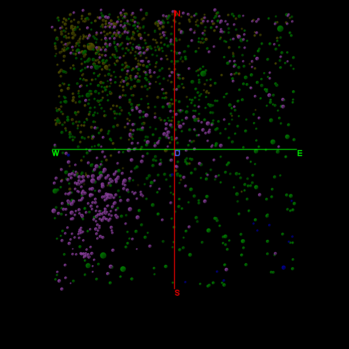
and the N, S , E or W Views don't show ground level at all, unless you set the rotation to "Top to Bottom"
Taupo under rotation
maybe its too small of an area.
Doesn't include Lakes
S -38.61, N -39.10
W 175.65, E 176.2
Lake Taupo


and the N, S , E or W Views don't show ground level at all, unless you set the rotation to "Top to Bottom"
Taupo under rotation
maybe its too small of an area.
edit on 10u29329313 by muzzy because: (no reason given)
reply to post by muzzy
Thanks. Glad you find it useful. There will be an update tomorrow to fix the missing text on the HTML List page and to sort out the Lat/Lon over the meridians which I have inadvertently messed up by pulling code from one of my other programs.
You will not be aware but when you launch a map, 3D or HTML List the launch code is placed in the clipboard. This was part of my testing to add it to different browsers. When you do all three the last past the post (HTML) is the one in the clipboard.
I am not able to change that without a lot of work, but I am retaining the ability to dump the link in the clipboard. I have added options for Browser, Clipboard or Both. The form will also automatically save your settings unless to tell it not to. This will also be in the update.
This is the new screen showing the additions
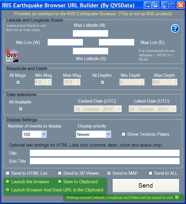
There may be some other twiddles and things depending on rosswellian's response on how to create the correct sz= parameter which at present is simply left off.
I can't remember if the help page was connected or not in that version so just in case the 'i' button does not work, here it is
Thanks. Glad you find it useful. There will be an update tomorrow to fix the missing text on the HTML List page and to sort out the Lat/Lon over the meridians which I have inadvertently messed up by pulling code from one of my other programs.
You will not be aware but when you launch a map, 3D or HTML List the launch code is placed in the clipboard. This was part of my testing to add it to different browsers. When you do all three the last past the post (HTML) is the one in the clipboard.
I am not able to change that without a lot of work, but I am retaining the ability to dump the link in the clipboard. I have added options for Browser, Clipboard or Both. The form will also automatically save your settings unless to tell it not to. This will also be in the update.
This is the new screen showing the additions

There may be some other twiddles and things depending on rosswellian's response on how to create the correct sz= parameter which at present is simply left off.
I can't remember if the help page was connected or not in that version so just in case the 'i' button does not work, here it is
reply to post by muzzy
Mm, in my humble opinion that should be included - at least for large bodies of water.
BTW I had a response from Rob Casey of IRIS tanking me for the feed back. I am just about to send details of the IEB to Armand at Earthquake-Reports as he may not have seen it and could link to it from his site.
Mm, in my humble opinion that should be included - at least for large bodies of water.
BTW I had a response from Rob Casey of IRIS tanking me for the feed back. I am just about to send details of the IEB to Armand at Earthquake-Reports as he may not have seen it and could link to it from his site.
reply to post by PuterMan
Didn't notice any missing text.
heres the HTML I got for that Taupo search
How cool would it be if you could get this to work on any JSON file (or whatever it is that provides the data to the IEB/3DV program.!
Didn't notice any missing text.
heres the HTML I got for that Taupo search
How cool would it be if you could get this to work on any JSON file (or whatever it is that provides the data to the IEB/3DV program.!
reply to post by muzzy
The missing text is:
from the earliest to the latest available, all depths, with priority for most recent, and limited to xxxxx where xxxxx is the number of events the list is limited to.
Yup that was my desire, but that can only be achieved with rosswellian's help and it may be low priority even though we may consider it a 'must have'. Since Rob Casey has told me to blast any suggestions to John Taber (rosswellian??? or rosswellian's boss???) then I shall do just that as I can do it from the angle of emailing Rob.
Didn't notice any missing text.
The missing text is:
from the earliest to the latest available, all depths, with priority for most recent, and limited to xxxxx where xxxxx is the number of events the list is limited to.
How cool would it be if you could get this to work on any JSON file (or whatever it is that provides the data to the IEB/3DV program.!
Yup that was my desire, but that can only be achieved with rosswellian's help and it may be low priority even though we may consider it a 'must have'. Since Rob Casey has told me to blast any suggestions to John Taber (rosswellian??? or rosswellian's boss???) then I shall do just that as I can do it from the angle of emailing Rob.
edit on 21/10/2013 by PuterMan because: can't even have green decoration now, it is grey
reply to post by PuterMan
They might not be too keen, seeing as it is likely IRIS funded the development of the program ( just guessing) and they might want to keep it IRIS data specific.
They might not be too keen, seeing as it is likely IRIS funded the development of the program ( just guessing) and they might want to keep it IRIS data specific.
reply to post by muzzy
as it says on my Avatar "Mood: Skeptical", I like to pick things to pieces.
because that 3DV of Taupo didn't work out properly I did an Excel graph using the IRIS data ( off the HTML Table) in the old 2011 NZ Cross Sections style, and got quite a different cross section view than 3DViewer
this is the view looking north through Lake Taupo, West on the left

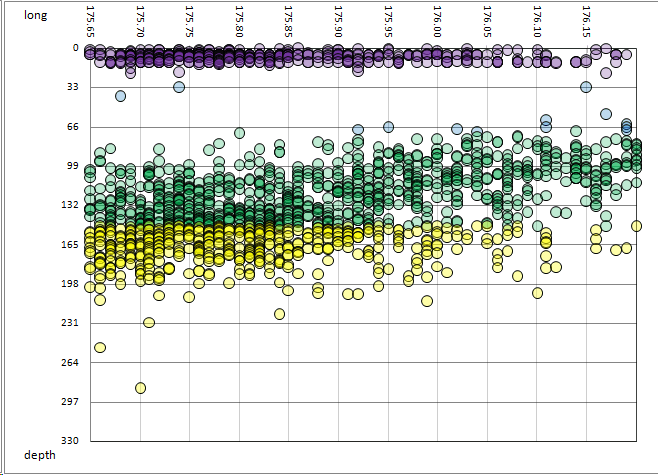
I will wait till ross gets back with the reason the IEB Map and the 3DV don't match up, may be something to do with the 3DV up/down axis and small area.
and perhaps my graph need to narrow down the cross section latitude band even further .................
as it says on my Avatar "Mood: Skeptical", I like to pick things to pieces.
because that 3DV of Taupo didn't work out properly I did an Excel graph using the IRIS data ( off the HTML Table) in the old 2011 NZ Cross Sections style, and got quite a different cross section view than 3DViewer
this is the view looking north through Lake Taupo, West on the left


I will wait till ross gets back with the reason the IEB Map and the 3DV don't match up, may be something to do with the 3DV up/down axis and small area.
and perhaps my graph need to narrow down the cross section latitude band even further .................
edit on 10u29329313 by muzzy because:
(no reason given)
I searched back four pages and saw no mention of the four moderate quakes in Israel in four days. So, my apologies if I missed them. This is very
unusual for the area they are in. This leaves me wondering what may be coming.
There have been three instances of a series of four "blood moons" in biblical history that fall on the same two Hebrew holy days in two consecutive years. Each time they happened Israel has suffered a severe judgement.
Now there is a final prophesied series of four blood moons coming in 2014/2015. If history holds true and biblical prophecy is accurate Israel will face a final judgement during this period and it will involve earthquakes. That leaves me wondering if the four moderate quakes in four days in an unusual area for quakes of that frequency is a precursor of things to come.
Below is the content of an e-mail from Joel Rosenberg concerning the quakes. You can also Google the term "four blood moons" and find a plethora of listings about them.
New post on Joel C. Rosenberg's Blog
Epicenter: Israel hit by four earthquakes in four days. “An earthquake in Israel is more dangerous than war.”
by joelcrosenberg
"Officials from the IDF Home Front Command and the emergency services held a status meeting Sunday night to discuss the readiness of the Israeli home front, following a fourth earthquake in northern Israel in just four days," reports the Times of Israel. "The meeting was held at the Ministry of Home Front Defense at the behest of Minister Gilad Erdan (Likud), and was attended by representatives of Israel’s paramedic, firefighting and police services, and of the Defense, Health and Education ministries."
Excerpts:
The officials decided to continue monitoring the situation while increasing home front readiness for natural disasters, Army Radio reported.
For the second time Sunday, a minor earthquake shook northern Israel around 4 p.m., the fourth of its kind since Thursday.
No injuries or damage were reported, but Tiberias residents told Ynet that they felt the 3.6-magnitude quake. The first quake Sunday also registered 3.6 on the Richter scale quake. Both epicenters were near Kibbutz Ginosar, on the Sea of Galilee.
Similarly powerful quakes rattled the north early Saturday morning and Thursday. Last Sunday, a 6.4-magnitude quake, centered in the Mediterranean Sea near Crete, was felt in Athens, Egypt and Israel. In September, an early-morning 3.5-magnitude quake was felt in the northern Dead Sea area, including in Jerusalem.
Israel held a massive Home Front drill last October, codenamed Turning Point 6, which was aimed at raising the preparedness of citizens, local authorities, and emergency services for dealing with natural disasters.
The exercise exposed significant shortcomings in Israel’s ability to respond to natural and man-made disasters, particularly in the lack of coordination between the army, the police and emergency services.
One of the greatest challenges to Israel’s preparedness is the fact that the majority of buildings in the areas likely to be hit by earthquakes were built before the first Gulf War in 1990, and have not been properly reinforced to withstand earthquakes.
Should Israel, in fact, face an earthquake emergency, it would be necessary to receive a great deal of assistance from around the world in handling the damage and injuries, Channel 2 reported at the time.
“An earthquake in Israel is more dangerous than war,” the then-chief of the Home Front Command warned.
In the non-fiction book, Epicenter, I note that Bible prophecy warns of several catastrophic earthquakes that will strike Israel in the "last days."
reply to post by PuterMan
Maybe I'm too much of a klutz about such things . . . but it would help folks like me . . . to have a listing of the more common landmarks around the globe vs putting lat and long in.
I finally went to a globe . . . since Google maps was no use, interestingly . . . trying to get the lat & lon of El Hierro to put in your form.
I finally saw from my globe . . . about 15 W to 30W, I think and about 10 to 30 N
Somehow I did it wrong and kept ending up in Egypt.
And for some reason the 3D version seems to not be available today?
And, it kept pulling up IE . . . I have Chrome open. How about a way to select browser to be used???
FWIW.
Much appreciate all your hard work.
THX THX.
BO XIAN
reply to post by PuterMan
Maybe I'm too much of a klutz about such things . . . but it would help folks like me . . . to have a listing of the more common landmarks around the globe vs putting lat and long in.
I finally went to a globe . . . since Google maps was no use, interestingly . . . trying to get the lat & lon of El Hierro to put in your form.
I finally saw from my globe . . . about 15 W to 30W, I think and about 10 to 30 N
Somehow I did it wrong and kept ending up in Egypt.
And for some reason the 3D version seems to not be available today?
And, it kept pulling up IE . . . I have Chrome open. How about a way to select browser to be used???
FWIW.
Much appreciate all your hard work.
THX THX.
First of all: The latest version with the fixes and enhancements I mentioned above is done
IEBUrlBuilder_1-1-2-0_setup.zip
Just download and install. This now saves settings. The cross anti-meridian boo-boo is fixed and the missing text.
to have a listing of the more common landmarks around the globe vs putting lat and long in.
Yup hear you. There are a few in the IEB but fire away with co-ordinates and names and I will create a facility for that.
ETA:
And, it kept pulling up IE . . . I have Chrome open. How about a way to select browser to be used???
I already had that in mind as it is a built in facility in QVS Data that has not been implemented yet for users. You must have IE as you default as the program just blats your default browser with the link.
I feel version 1.2 coming on!!
edit on 21/10/2013 by PuterMan because: (no reason given)
reply to post by muzzy
I am sure it because the grid is too small. You have less than one degree there.
I can't even zoom out to get a look at it.
I am sure it because the grid is too small. You have less than one degree there.
I can't even zoom out to get a look at it.
Yes the Up/Down Axis definitely needs to be adjustable on 3DV.
Still at Lake Taupo (which is a volcano BTW)
With narrower slivers of Latitude you get very different cross sections (North View in 3DV).
Which raises the question of " how accurate are those 3D North Views when you take more of a square search rather than a narrow band rectangular search?".
Old style cross sections here, you can see what I mean when compared to the full square search in my previous post.
North Lake Taupo Map
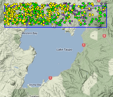
North Lake Taupo Cross Section
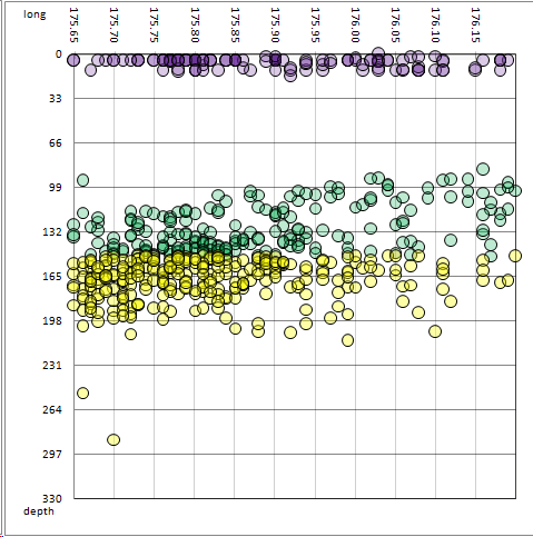
_______________________________________________
South Lake Taupo Map
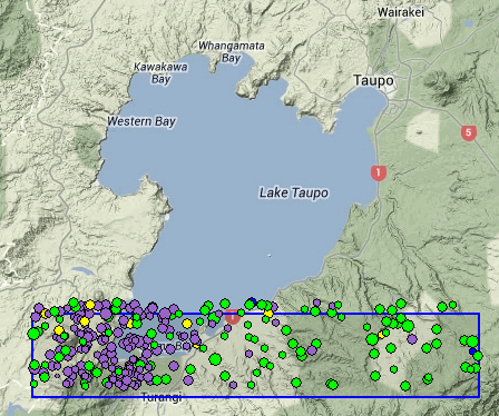
South Lake Taupo Cross Section
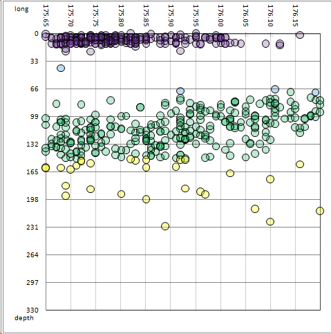
What those cross sections are showing me is that the green and yellow bands are the Wadati- Benioff Zone subduction dip, and the purple (0-33km zone) is volcanic quake activity in and around the lake (caldera)
Interesting there is little happening in the 33-99km layer.
Still at Lake Taupo (which is a volcano BTW)
With narrower slivers of Latitude you get very different cross sections (North View in 3DV).
Which raises the question of " how accurate are those 3D North Views when you take more of a square search rather than a narrow band rectangular search?".
Old style cross sections here, you can see what I mean when compared to the full square search in my previous post.
North Lake Taupo Map

North Lake Taupo Cross Section

_______________________________________________
South Lake Taupo Map

South Lake Taupo Cross Section

What those cross sections are showing me is that the green and yellow bands are the Wadati- Benioff Zone subduction dip, and the purple (0-33km zone) is volcanic quake activity in and around the lake (caldera)
Interesting there is little happening in the 33-99km layer.
edit on 1000000029329313 by muzzy because: (no reason given)
reply to post by BO XIAN
OK I have decided to add area Shapes as per the ones that are stored in QVSData. By that means when this program is slotted in to QVSData it can continue to draw on the shapes in the configuration database.
As a suggestion these are the one in my config database.
ALGIERS,29.0000,37.0000,-1.0000,8.0000
AMERICAN30S,30.0000,39.9900,-125.0000,-75.0000
BAJA CALIFORNIA,31.0000,34.5000,-118.0000,-114.5000
CAMPI FLEGRI,40.8500,40.7900,14.0300,14.1200
CHAITEN AREA,-43.2000,-42.4000,-72.9000,-72.3000
CHILE 2010,-39.5000,-31.0000,-75.0000,-69.3000
CLEVLAND VOLCANO ALASKA,52.0000,53.5000,-170.5000,-168.5000
COLORADO - NEW MEXICO BORDER,36.0000,38.0000,-109.0000,-102.0000
CUBA HAITI REGION,16.0000,21.0000,-76.0000,-61.0000
GREATER ALASKA,56.0000,67.0000,-161.0000,-137.0000
GULF OF ADEN,10.0000,14.0000,43.0000,46.0000
HINDU KUSH,34.0000,37.5000,69.0000,72.0000
KILAUEA AREA,19.2200,19.5000,-155.2500,-155.1200
MELIMOYU AREA,-44.2000,-43.5000,-73.5000,-72.0000
NCAL JDF PLATE,40.0000,45.0000,-132.5000,-123.5000
NEVADA TEST RANGE,37.6000,37.7000,-116.8000,-116.4000
PUERTO RICO,17.8000,19.4000,-67.8000,-65.3000
SANTA CRUZ ISLANDS,-13.5000,-10.0000,164.0000,169.0000
SANTORINI - GREECE,36.0000,36.5000,25.0000,26.0000
TOBA AREA,1.0000,3.5000,94.0000,100.0000
VALPARAISO AREA,-32.0000,-32.9000,-73.0000,-71.0000
WIDER CA AREA,27.0000,40.0000,-123.0000,-114.0000
YELLOWSTONE PARK,44.1023,45.1085,-111.1074,-109.9800
ICELAND,62.2500,66.2500,-24.0000,-12.0000
THE GEYSERS AREA,38.7250,38.8750,-122.9000,-122.6500
NEW MADRID SZ,34.5000,37.5000,-93.0000,-87.0000
TOBA CALDERA,2.0000,3.0000,98.2500,99.2500
I will add El Hierro in and maybe grab the ones in IEB as well.
Add any more you wish, but you will be able to maintain your own list in the program.
As far as browsers go I have added Chrome, Firefox, Internet Explorer and Opera and it works with all of those. They choice gets saved so you don't have to change to another if you don't want to. I have NOT looked to see what is installed as that adds a layer of security considerations that I don't want to deal with in such a small program.
The name of the browser executable gets pushed at the process controller and if that fails it defaults to the default installed browser. I am hoping to get that done in the next hour before I retire for the night, but no promises.
reply to post by BO XIAN
That is from Bissau to above the Canaries and from... never mind - way too large an area
This is El Hierro: EL HIERRO,27.3000,28.1000,-18.5000,-17.6000
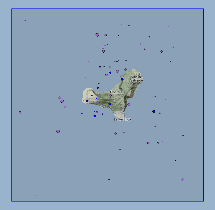
A bit on the small side but works just about.
about 15 W to 30W, I think and about 10 to 30 N
That is from Bissau to above the Canaries and from... never mind - way too large an area
This is El Hierro: EL HIERRO,27.3000,28.1000,-18.5000,-17.6000

A bit on the small side but works just about.
new topics
-
To become president, Zelensky had to learn Ukrainian
Political Conspiracies: 1 hours ago -
Green Grapes
General Chit Chat: 5 hours ago -
Those Great Fresh Pet Commercials
Television: 10 hours ago
top topics
-
Joe meant what he said about Hunter's pardon....
US Political Madness: 14 hours ago, 12 flags -
S.C. Jack Smith's Final Report Says Trump Leads a Major Conspiratorial Criminal Organization!.
Political Conspiracies: 12 hours ago, 11 flags -
Advice for any young Adult .
General Chit Chat: 13 hours ago, 10 flags -
Green Grapes
General Chit Chat: 5 hours ago, 5 flags -
It’s Falling…
Philosophy and Metaphysics: 16 hours ago, 4 flags -
Regent Street in #London has been evacuated due to a “bomb threat.”
Other Current Events: 15 hours ago, 3 flags -
Those Great Fresh Pet Commercials
Television: 10 hours ago, 3 flags -
To become president, Zelensky had to learn Ukrainian
Political Conspiracies: 1 hours ago, 3 flags
active topics
-
Los Angeles brush fires latest: 2 blazes threaten structures, prompt evacuations
Mainstream News • 116 • : WeMustCare -
To become president, Zelensky had to learn Ukrainian
Political Conspiracies • 1 • : berbofthegreen -
What Comes After January 20th
Mainstream News • 34 • : charlest2 -
Some sausage, some chicken, some sauce, some onions and some garlic...and some peppers!
Food and Cooking • 4 • : putnam6 -
S.C. Jack Smith's Final Report Says Trump Leads a Major Conspiratorial Criminal Organization!.
Political Conspiracies • 42 • : WeMustCare -
House Passes Laken Riley Act
Mainstream News • 22 • : KrustyKrab -
Russia Ukraine Update Thread - part 3
World War Three • 6904 • : Imhere -
Steering the Titantic from the Drydock.
Rant • 43 • : charlest2 -
President Carter has passed
Mainstream News • 44 • : WeMustCare -
Those stupid GRAVITE commercials
Rant • 13 • : GENERAL EYES
