It looks like you're using an Ad Blocker.
Please white-list or disable AboveTopSecret.com in your ad-blocking tool.
Thank you.
Some features of ATS will be disabled while you continue to use an ad-blocker.

Atlantis has been discovered?!
page: 19share:
originally posted by: All Seeing Eye
originally posted by: Byrd
originally posted by: All Seeing Eye
a reply to: Harte
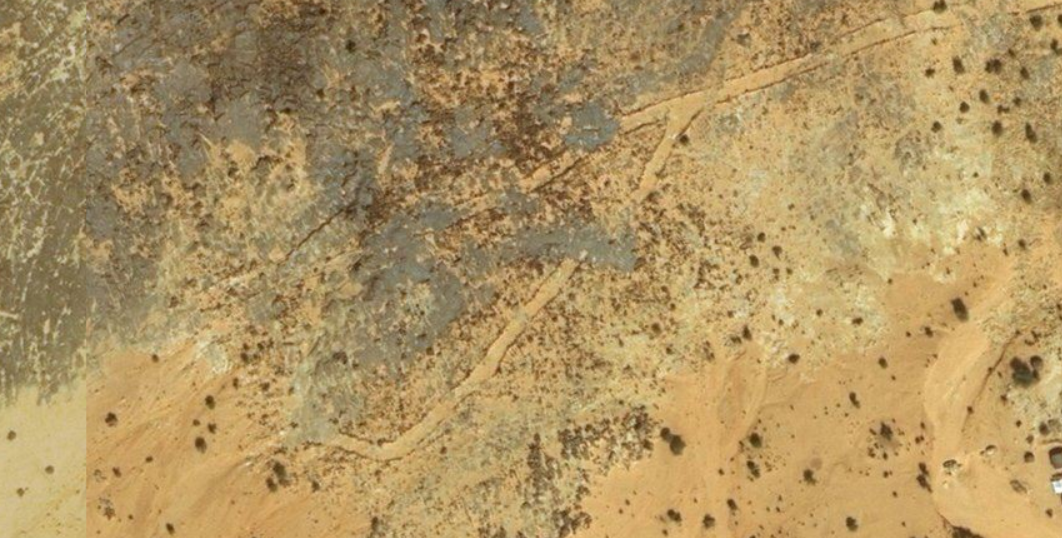
To compare the first image against this one. To the left is a block, to the right look at the patterns in the stone. These hills in this area and others have this same pattern. They are a natural source for large building blocks.
We agree, this area is a quarry.
Sorry, but that's a dreadful image quality.
The thing on the left isn't a block. It's a depression. It doesn't appear to be a quarry.
Here is a zoomed image of that particular, specific, stone.
If, it were a depression the shadow would be on the other side. The irregular rocks to the right are all above ground and the shadows are all on the same side. It is not a depression, the object is sitting, on the surface.

They're pits and ridges, I believe. Not above ground boulders.
originally posted by: All Seeing Eye
You seem to have overlooked the man made objects present on these levels.
I haven't. When I see human structures, I call them out.
originally posted by: SLAYER69
a reply to: All Seeing Eye
No it hasnt been, WAIT FOR IT.....
I'm a shaken boss, I'm a shaken lol
originally posted by: All Seeing Eye
a reply to: Byrd
What were you expecting me to see?
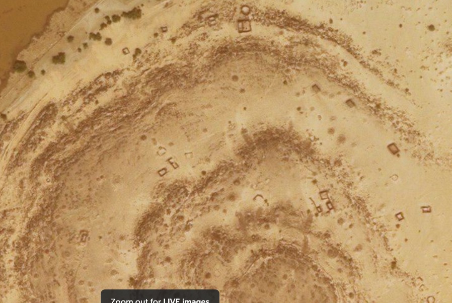
This entire site, is over 20 square miles.
It's the North Hodth dune field (and goes further than that) along the Nema Escarpment.
An annotated map (from a traveler) on Google Earth of the roads ... that was in 2007. Also noted on traveler forums and blogs that there are military bases and mine fields around. I did not look up general locations for that.
Related: 2006 blog about travel in Mauritania
I want you to see the extensive road network.
I see dirt roads for vehicles... the ones shown in a GIF from that blog that show them connecting small towns in the area
You can see a map of the asphalt roads here All other roads are basically what we'd call "goat tracks" here in Texas. Driven by cars and trucks but unpaved.
No modern vehicles present in that 20 Sq miles. There is a radio tower that is in the area, but that is no reason to have all these well defined roads. There are tire tracks, well driven, but not one human being seen, but, in saying that, there are many examples of humans present, putting white tarps over something in the ground, in many places. There are orange "tags" on several of the sites. There are white tags in a few locations painted on the ground. Recently, one area had a "trailer" brought in. I have seen no indications of Nomad tents, you can tell the difference. These things are indicative of a servery being conducted. And who would be doing that? Not you, not me, but, there are boots on the ground in this area, they left their marks.
The military is active in the area (it's a hotspot for bandits, as you could see from reading the blog above. And (as per that blog) the roads seem to run between towns. At least the stuff that my experience tells me are roads. There's also a number of fault lines in the area, but the thing that you marked on the map is a known road.
I don't see any "big blocks" lying around and (per the blog ...and I'm looking up traveler reports) there are no reports of "massive blocks of stone lying around.
originally posted by: Byrd
originally posted by: All Seeing Eye
You seem to have overlooked the man made objects present on these levels.
I haven't. When I see human structures, I call them out.
Please do. You can start with these. What are they, who put them there, for what reason. You can try to place them in a timeline but that's really going to be tough.
Please supply examples, images, you logic and reasoning. Ya know, call them out. If you need to, zoom in and study them, there location. "Its a blurry image" just won't cut it because you have access to good imaging software.
ADDED: None of your links provide information concerning the area in discussion. Though, I would agree, the military have a presence in the area.
edit on PMTuesdayTuesday thAmerica/ChicagoAmerica/Chicago0987 by All Seeing Eye because: (no reason given)
originally posted by: All Seeing Eye
originally posted by: Byrd
originally posted by: All Seeing Eye
You seem to have overlooked the man made objects present on these levels.
I haven't. When I see human structures, I call them out.
Please do. You can start with these. What are they, who put them there, for what reason. You can try to place them in a timeline but that's really going to be tough.
Please supply examples, images, you logic and reasoning. Ya know, call them out. If you need to, zoom in and study them, there location. "Its a blurry image" just won't cut it because you have access to good imaging software.
ADDED: None of your links provide information concerning the area in discussion. Though, I would agree, the military have a presence in the area.
(sigh) Because Ileaped into the discussion, I did NOT do what I should have done all along... and started with "what do we know"? Get the geography, the geology, the history, the culture.
I'm reading through what I can find. However, I believe I *have* found an answer to some of the recent abandoned areas, and that's the drought that started in Mauritania back in the late 1980's. According to several articles, the nomadic and semi-nomadic people had to abandon their small farms and fields and move to the cities.
link to one article
I'm too tired to go hunt down the precise quote tonight (will do it at another time) but the population was largely nomadic until recently when the lack of rain and resources forced them to abandon their structures and move to the cities.
No, I don't know which ones. Right now I'm trying to work my way through the geology and geography and get familiar with that... then the history. There's a number of notable ruins from the original empire listed in one web page and I'm trying to track those down, too.
And this is what I learned as a scholar... start by mapping out what people think they know about the area/subject. Double-check and verify the information, and then you know where to look and where NOT to look and know a lot about what you're seeing... or not seeing. Sadly, I have other commitments so I'll be fairly slow at it. But i stand by my statement that nothing you've shown us are unexplained and unexplored ruins.
a reply to: Byrd
"other commitments"
No problem, I already understand.
In the mean time, this just popped up. Makes me laugh, Goggle Earth lol
strangesounds.org...
"other commitments"
No problem, I already understand.
In the mean time, this just popped up. Makes me laugh, Goggle Earth lol
400 mysterious ancient stone structures discovered across old lava domes in Saudi Arabia
Made of low stone walls that are sometimes built in a rectangular shape the purpose and exact date of the gates are unknown although researchers believe that they date back thousands of years.
strangesounds.org...
originally posted by: All Seeing Eye
a reply to: Byrd
"other commitments"
No problem, I already understand.
In the mean time, this just popped up. Makes me laugh, Goggle Earth lol
400 mysterious ancient stone structures discovered across old lava domes in Saudi Arabia
Made of low stone walls that are sometimes built in a rectangular shape the purpose and exact date of the gates are unknown although researchers believe that they date back thousands of years.
strangesounds.org...
Actually, I've been aware of them for some time and of the various discussions around them. Haven't gone to look them up on maps but I know they're there and are similar enough in structure to be product of one culture. I have a vague memory that these gates are found up towards Israel/Palestine.
Meanwhile, here's a reasonable map of the geography of Mauritania that can serve as a reference
And when looking for "what's been written" (or drawings or photographs) we now have some names for the area instead of "Mauritania." There's probably better maps out there, but for a start we need to know logical (or geological) sections. That tells us about the stone and resources and culture.
Ideally (if this was a project for my students) I would then ask them to create a map on Google Map or another resource where people could label areas (correlate the map with the satellite photos) and then cross-check with other maps (including historical maps) to make sure we have a good sense of what's known. This reduces misidentification.
Once we know the structure, then we start asking more about history and culture and tribes in the area. That's a trickier question but again eliminates some obvious things and reduces misidentification.
a reply to: Byrd
The general information you provide is greatly appreciated, including your time you are spending in this, adventure.
I guess I should explain a few "Generalities" about myself. I look at these sites, and many other sites, from outside the Archeological Paradigm. From that standpoint I do not have any preconceived limitations of the "Whats" possible, and what isn't. Or for that matter, what is and what isn't being seen. I am able to consider all information, from any source. From, any timeline.
This precludes me from being guided by faulty past assumptions or individual prejudice's of one subject or another. As an example I give you Benjamin Jowett. In the beginning of his translation of the Critias he goes on to explain the logic of why "Atlantis" was a myth, by injecting his assumptions into the minds of the "Actors" on a theatrical stage. Though it never occurred to him, that Theater was today's TED TALKS. Some things never changed. When he did this to his students it was like pinning their minds to the ground, and the students never knew it. How many discoveries could those students have made, if only their teacher hadn't of limited their inquisitiveness. How many other "Teachers" have done this very same thing in other areas of study. I say, NO, I will not be entrapped in a paradigm cage. But also in saying that, I do not throw the baby out with the bathwater. The Scientific method is a very good teacher in itself and the discoveries speak for themselves.
For the subject of "Atlantis" being myth or based in some lost truths, well, if one takes into consideration that ancient structures have been discovered off the coast of India, Cuba, and Egypt, under ocean water (water levels rose approx 13,000 years ago), then the possibility of the concept of Atlantis being real, goes up dramatically. Re read Plato's exact words. The world was sectioned off into "Allotments". He does not give the names of the other allotment, and only gave us one, "Atlantis". Those discoveries were in their own allotments, not in the allotment called Atlantis. Plato states The capital City, the name of which is confused with the name of the allotment was destroyed by water, but also states they way to that city was blocked by deep mud. Mud that would have flowed like lava, filling in low lying areas,structures.
For me, I have found sufficient evidence on the ground that supports the theory that there was a city in the eye, and more than enough infrastructure in the surrounding area to support, a city of that reported size.
I have also found enough evidence to support the theory that there are groups, factions, that wish the evidence of this discovery, to remain buried. It is in their best interest to do this, not mankind's as a whole. I have my suspicions to what part they may have played during the days of "Atlantis". And what parts they play, today.
Now the question is, would these "Players" destroy these new discoveries, or would they attempt to just put them in a different context, paradigm to hide the evidence, that is in plane sight. That would depend on the ease of operation, size and nature of the discovery. Say, what happened to all those "Giant's" bones sent to the Smithsonian museum???
Some of the sites in this area actually remind me of some of the stunts the allies and axis pulled during WWII with mock airfields, equipment made of inflatable's make to look like tanks, planes. A direct example of placing one object in a completely different context, to mislead. Nothing new under the Sun..
Now, you were saying something about these items in the image?
a reply to: Byrd
I don't think I have said those things. As I study this area there are boots on the ground. The areas of interest to "Someone" are being marked with color tags. Blue, orange and white. So, someone is doing something in the area. Some of the stones are painted. There are quite a few "Tarps" staked to the ground. These tarps all have a blue section in them, in the center only on one side. Too blurry to make out whats in the blue section. One of the boxes has what appears to be the numbers 16.
In another area "Boxes" have been moved around and in the same area it appears a work trailer has been bought in.
So, I agree, someone, has a explanation, and it is being explored. And I can find no information on this area.
But i stand by my statement that nothing you've shown us are unexplained and unexplored ruins.
I don't think I have said those things. As I study this area there are boots on the ground. The areas of interest to "Someone" are being marked with color tags. Blue, orange and white. So, someone is doing something in the area. Some of the stones are painted. There are quite a few "Tarps" staked to the ground. These tarps all have a blue section in them, in the center only on one side. Too blurry to make out whats in the blue section. One of the boxes has what appears to be the numbers 16.
In another area "Boxes" have been moved around and in the same area it appears a work trailer has been bought in.
So, I agree, someone, has a explanation, and it is being explored. And I can find no information on this area.
originally posted by: All Seeing Eye
a reply to: Byrd
The general information you provide is greatly appreciated, including your time you are spending in this, adventure.
I guess I should explain a few "Generalities" about myself. I look at these sites, and many other sites, from outside the Archeological Paradigm. From that standpoint I do not have any preconceived limitations of the "Whats" possible, and what isn't. Or for that matter, what is and what isn't being seen. I am able to consider all information, from any source. From, any timeline.
You are not unique. This exact mindset is present in nearly everyone who isn't trained in archaeology and who goes exploring satellite images. Welcome to the club. It's a big one.
This precludes me from being guided by faulty past assumptions or individual prejudice's of one subject or another.
Except... it doesn't preclude you from that.
You've just gone in assuming that everything scientists and geologists have said about the area is wrong or that they managed to misinterpret (something that they've been studying in depth for decades and with tools you don't have.) You also assume that the records of the area (told by people who live there) are wrong. And it's not just one person who's wrong, it's a whole chain involving anyone stretching back through history who has ever studied the area is wrong. Thousands of people from many different cultures and countries.
All wrong.
They have nothing of value to contribute.
NOW... compare the scientist's approach. We assume that others have done both honest work as well as politically biased work as well as culturally framed work (the French exploration of Egypt, for instance, didn't involve Egyptians but Frenchmen who had their own idea of the culture and so forth. In spite of that bias (which we know) they made some excellent and detailed drawings of monuments that have now disappeared and of hieroglyphs that were destroyed later on.)
Remember the scientific method?
1. Define the problem -- and frame it as a question.
2. Research the problem or Review of literature Research the problem
3. Formulate a Hypothesis
3 b.) At the same time decide what indications will determine if you're on the wrong track with your hypothesis)
4. Observe and collect data on a sample (in order to test if what you are observing/measuring is the RIGHT thing and whether it'll tell you what you need to know.
5. If the method is sound, collect and observe the data.
5. b.) if the method wasn't sound, go back to step 1
6. With the data all in, analyze it, form your conclusions.
7. En garde! Write the paper, share it, and prepare to defend it against others who come along with "you didn't consider this..."
(as an example, a friend of mine tossed a set of findings to me that included something about how eyes are positioned when people drive. His profs and all were happy with it, until I pointed out that he neglected one key data point -- how old the driver was and whether they wore bifocals or trifocals. So now they have to investigate that.)
The kind of "independent researcher" you talk about does step 1, MAYBE some step 2, 3a (but not b), skip 4, does 5 a but not b and then 6 and 7 and if anyone comes up with a counter or points out things they didn't consider that they should have learned with a good reading (and all the parts they missed) they yell about science, hidden histories, occult masters, etc.
...instead of yelling about bad research.
For me, I have found sufficient evidence on the ground that supports the theory that there was a city in the eye, and more than enough infrastructure in the surrounding area to support, a city of that reported size.
Okay...tough question: Have you REALLY?
You need to prove what your "blocks" are. Aerial photos won't do.
You need to show what infrastructure and the age of that infrastructure... and how you know that it's that particular age and not, say, something from the 1800's.
You need to show what the landscape was; what kind of vegetation and how you know that from the time period (proving that it could support a large population.)
You need to show the port areas and show from geological samples that there WAS water there some 10,000 years ago (or whenever.)
...at least, this is what I'd have to be doing if I was going to march up to a group of people and announce "hey, dudes! I found Atlantis." I have to show evidence that there's something there that could be located on a dig and a survey. I can't just say "no, really I found it! Look at this myth from the 12th century Arabs! That's all you need to know!"
I want truth, but I'm a very harsh critic. I don't care how well someone talks or how well they present themselves -- that's like buying a car based on its color. I want to know what's under the hood, what brand of spark plugs they're using, whether the air filter is off market or original, how many miles it's got on it, what its driving history really is, whether it's 4 or 8 cylinders, dual or single camshaft, whether it's got poor compression, whether the timing belt/chain is slipping... and so on and so forth. I don't want to see the video. I want to see the specs, and I want to see all of them.
a reply to: Byrd
Right off the bat we have a issue. I was taught 1. Make a observation. 3.Formulate a Hypothesis. You cant form a hypothesis until you gather all information available.
I have been gathering info for over 40 years. It takes time to sort through all of it, categorize, prioritize, compare, then sift.
It all started in 1978, with a observation, not, a problem. Even though at the end of all that research, it exposed a problem. And it seems that problem goes all the way back to "Atlantis". And that is where I am now.
I answered the question as to what I saw to my satisfaction. If I felt mankind should know the truth of that vision I would make a thread. But knowing the truth of the observation, it, is quite capable of informing mankind, if, and when, it chooses to.
Along that very long path I had to search in many different areas for that information and discovered other truths, evidence, too many to list here.
So, if I were to use your method, the problem is "Mankind has been lied to from at least the Great Flood".
The research indicates "Secret Societies are responsible for the manipulation and deceptions". The research indicates these societies had their origins in Atlantis, with a blood oath of the Demi Gods, and their bloodlines.
No where does your method mention, how to resolve the problem. Only, write a paper, that in itself, dos not solve the problem.
The problem I propose involves exposing the evidence, to the people, to let them decide how to solve the problem, that involves all of mankind.
To the sites I have discovered, observed, they all display the same elements. They are all tied together by a well defined road that appears to be well weathered by wind, rain, AND Flooding. In fact, many of the sits display flood damage, and a great deal of it. Some of the roads are very remote and have not been used by modern vehicles. And these sections appear to have the same patina as the surrounding rocks. The site at 19°35'0.08"N 13°18'17.56"W appears to have been wiped out by flooding and the only remaining elements are on higher ground, sheltered by the mountain behind it. At 19°32'55.10"N 13°19'59.67"W there is a field of the Hockey Puck" shaped stones, 3 miles away from the above site. I suspect these were "Washed" that far, by flood water. I personally have seen boulders being washed down stream by flood water. It can happen.
One site, 20° 1'12.92"N 13°16'21.52"W, in particular displays a circular stone structure very similar to the discoveries Michael Tellinger discovered in South Africa. His claim of 200,000 years old seems to be debatable, so we would have to rely on the science used. Without physically being able to gather direct evidence I can only guess to the age.
One complication in this area is that it appears man has lived in this area off and on for quite some time. I would guess since the time of all this major flooding. The only dating that I know of is the one site, 20°59'55.69"N 11°26'21.15"W, outside the eye, and no science was used to confirm the age and left the mud brick structure as, ancient.
One site is virtually identical as the above. It too appears to be mud brick buildings that have melted down leaving its footprint, 19°55'6.31"N 13°19'34.61"W. So, all I can imagine, is, ancient, as no water and vegetation has been available in this area to build mud brick buildings since at least 4000bc, or ancient.
This is only a Preliminary report of the "Observations". Not Authoritative.
List of sites in question. Area Covered: 200 miles X160 miles. As I said, its massive.
20° 1'12.92"N 13°16'21.52"W
19°59'29.43"N 13°17'19.95"W
19°58'54.80"N 13°17'42.38"W
19°59'38.12"N 13°18'7.19"W
19°59'12.05"N 13°20'37.52"W
19°59'32.61"N 13°20'39.90"W
19°59'13.73"N 13°20'54.97"W
19°57'32.61"N 13°23'40.40"W
19°56'54.79"N 13°23'57.76"W
19°52'26.73"N 13°33'18.66"W
19°52'20.03"N 13°33'5.64"W
19°52'4.36"N 13°33'49.31"W
19°51'37.85"N 13°33'57.52"W
19°51'33.69"N 13°34'31.19"W
19°51'36.01"N 13°34'42.77"W
19°51'23.72"N 13°34'43.80"W
19°51'15.28"N 13°34'43.73"W
19°51'7.73"N 13°34'51.18"W
19°51'23.38"N 13°35'1.76"W
19°51'17.07"N 13°35'17.36"W
19°51'27.38"N 13°35'28.99"W
19°51'32.70"N 13°36'24.97"W
19°51'34.00"N 13°37'3.06"W
19°51'13.76"N 13°37'55.49"W
19°50'52.37"N 13°38'14.69"W
19°49'30.14"N 13°38'37.81"W
19°49'25.38"N 13°39'2.82"W
19°49'34.86"N 13°39'22.43"W
19°49'42.80"N 13°39'40.50"W
19°49'37.03"N 13°42'24.88"W
19°59'11.58"N 13°16'38.34"W
19°58'0.22"N 13°17'13.77"W
19°57'7.88"N 13°17'46.76"W
19°56'6.05"N 13°17'53.02"W
19°55'25.91"N 13°19'4.19"W
19°55'14.14"N 13°19'21.59"W
19°55'8.44"N 13°19'4.33"W
19°55'10.18"N 13°19'45.26"W
19°55'6.31"N 13°19'34.61"W
19°54'36.22"N 13°17'23.55"W
19°54'8.94"N 13°17'10.29"W
19°55'14.14"N 13°17'31.17"W
19°53'58.13"N 13°17'36.84"W
19°54'36.11"N 13°18'52.68"W
19°54'52.60"N 13°18'9.69"W
19°54'45.88"N 13°19'35.51"W
19°54'41.12"N 13°19'27.54"W
19°54'32.92"N 13°19'21.24"W
19°54'6.73"N 13°20'17.04"W
19°52'23.67"N 13°21'42.18"W
19°51'22.91"N 13°22'21.12"W
19°48'10.13"N 13°22'39.05"W
19°49'6.77"N 13°22'17.91"W
19°47'5.38"N 13°23'29.87"W
19°46'37.54"N 13°24'22.59"W
19°36'9.37"N 13°19'23.07"W
19°35'26.03"N 13°18'46.96"W
19°35'0.08"N 13°18'17.56"W
19°32'55.10"N 13°19'59.67"W
20° 0'49.38"N 13° 8'17.39"W
19°55'43.93"N 13° 5'7.90"W
19°53'14.91"N 13° 2'51.80"W
19°52'30.98"N 13° 2'22.18"W
19°52'4.44"N 13° 2'4.53"W
19°51'35.48"N 13° 1'1.95"W
19°51'5.64"N 13° 0'22.93"W
1. Define the problem -- and frame it as a question.
2. Research the problem or Review of literature Research the problem
3. Formulate a Hypothesis
Right off the bat we have a issue. I was taught 1. Make a observation. 3.Formulate a Hypothesis. You cant form a hypothesis until you gather all information available.
I have been gathering info for over 40 years. It takes time to sort through all of it, categorize, prioritize, compare, then sift.
It all started in 1978, with a observation, not, a problem. Even though at the end of all that research, it exposed a problem. And it seems that problem goes all the way back to "Atlantis". And that is where I am now.
I answered the question as to what I saw to my satisfaction. If I felt mankind should know the truth of that vision I would make a thread. But knowing the truth of the observation, it, is quite capable of informing mankind, if, and when, it chooses to.
Along that very long path I had to search in many different areas for that information and discovered other truths, evidence, too many to list here.
So, if I were to use your method, the problem is "Mankind has been lied to from at least the Great Flood".
The research indicates "Secret Societies are responsible for the manipulation and deceptions". The research indicates these societies had their origins in Atlantis, with a blood oath of the Demi Gods, and their bloodlines.
No where does your method mention, how to resolve the problem. Only, write a paper, that in itself, dos not solve the problem.
The problem I propose involves exposing the evidence, to the people, to let them decide how to solve the problem, that involves all of mankind.
To the sites I have discovered, observed, they all display the same elements. They are all tied together by a well defined road that appears to be well weathered by wind, rain, AND Flooding. In fact, many of the sits display flood damage, and a great deal of it. Some of the roads are very remote and have not been used by modern vehicles. And these sections appear to have the same patina as the surrounding rocks. The site at 19°35'0.08"N 13°18'17.56"W appears to have been wiped out by flooding and the only remaining elements are on higher ground, sheltered by the mountain behind it. At 19°32'55.10"N 13°19'59.67"W there is a field of the Hockey Puck" shaped stones, 3 miles away from the above site. I suspect these were "Washed" that far, by flood water. I personally have seen boulders being washed down stream by flood water. It can happen.
One site, 20° 1'12.92"N 13°16'21.52"W, in particular displays a circular stone structure very similar to the discoveries Michael Tellinger discovered in South Africa. His claim of 200,000 years old seems to be debatable, so we would have to rely on the science used. Without physically being able to gather direct evidence I can only guess to the age.
One complication in this area is that it appears man has lived in this area off and on for quite some time. I would guess since the time of all this major flooding. The only dating that I know of is the one site, 20°59'55.69"N 11°26'21.15"W, outside the eye, and no science was used to confirm the age and left the mud brick structure as, ancient.
One site is virtually identical as the above. It too appears to be mud brick buildings that have melted down leaving its footprint, 19°55'6.31"N 13°19'34.61"W. So, all I can imagine, is, ancient, as no water and vegetation has been available in this area to build mud brick buildings since at least 4000bc, or ancient.
This is only a Preliminary report of the "Observations". Not Authoritative.
List of sites in question. Area Covered: 200 miles X160 miles. As I said, its massive.
20° 1'12.92"N 13°16'21.52"W
19°59'29.43"N 13°17'19.95"W
19°58'54.80"N 13°17'42.38"W
19°59'38.12"N 13°18'7.19"W
19°59'12.05"N 13°20'37.52"W
19°59'32.61"N 13°20'39.90"W
19°59'13.73"N 13°20'54.97"W
19°57'32.61"N 13°23'40.40"W
19°56'54.79"N 13°23'57.76"W
19°52'26.73"N 13°33'18.66"W
19°52'20.03"N 13°33'5.64"W
19°52'4.36"N 13°33'49.31"W
19°51'37.85"N 13°33'57.52"W
19°51'33.69"N 13°34'31.19"W
19°51'36.01"N 13°34'42.77"W
19°51'23.72"N 13°34'43.80"W
19°51'15.28"N 13°34'43.73"W
19°51'7.73"N 13°34'51.18"W
19°51'23.38"N 13°35'1.76"W
19°51'17.07"N 13°35'17.36"W
19°51'27.38"N 13°35'28.99"W
19°51'32.70"N 13°36'24.97"W
19°51'34.00"N 13°37'3.06"W
19°51'13.76"N 13°37'55.49"W
19°50'52.37"N 13°38'14.69"W
19°49'30.14"N 13°38'37.81"W
19°49'25.38"N 13°39'2.82"W
19°49'34.86"N 13°39'22.43"W
19°49'42.80"N 13°39'40.50"W
19°49'37.03"N 13°42'24.88"W
19°59'11.58"N 13°16'38.34"W
19°58'0.22"N 13°17'13.77"W
19°57'7.88"N 13°17'46.76"W
19°56'6.05"N 13°17'53.02"W
19°55'25.91"N 13°19'4.19"W
19°55'14.14"N 13°19'21.59"W
19°55'8.44"N 13°19'4.33"W
19°55'10.18"N 13°19'45.26"W
19°55'6.31"N 13°19'34.61"W
19°54'36.22"N 13°17'23.55"W
19°54'8.94"N 13°17'10.29"W
19°55'14.14"N 13°17'31.17"W
19°53'58.13"N 13°17'36.84"W
19°54'36.11"N 13°18'52.68"W
19°54'52.60"N 13°18'9.69"W
19°54'45.88"N 13°19'35.51"W
19°54'41.12"N 13°19'27.54"W
19°54'32.92"N 13°19'21.24"W
19°54'6.73"N 13°20'17.04"W
19°52'23.67"N 13°21'42.18"W
19°51'22.91"N 13°22'21.12"W
19°48'10.13"N 13°22'39.05"W
19°49'6.77"N 13°22'17.91"W
19°47'5.38"N 13°23'29.87"W
19°46'37.54"N 13°24'22.59"W
19°36'9.37"N 13°19'23.07"W
19°35'26.03"N 13°18'46.96"W
19°35'0.08"N 13°18'17.56"W
19°32'55.10"N 13°19'59.67"W
20° 0'49.38"N 13° 8'17.39"W
19°55'43.93"N 13° 5'7.90"W
19°53'14.91"N 13° 2'51.80"W
19°52'30.98"N 13° 2'22.18"W
19°52'4.44"N 13° 2'4.53"W
19°51'35.48"N 13° 1'1.95"W
19°51'5.64"N 13° 0'22.93"W
edit on AMFridayFriday thAmerica/ChicagoAmerica/Chicago36812 by All Seeing Eye because: (no reason given)
originally posted by: All Seeing Eye
a reply to: Byrd
1. Define the problem -- and frame it as a question.
2. Research the problem or Review of literature Research the problem
3. Formulate a Hypothesis
Right off the bat we have a issue. I was taught 1. Make a observation. 3.Formulate a Hypothesis. You cant form a hypothesis until you gather all information available.
Right. Which means you read the literature and research what you know about it. Defining the problem is "You see something curious. What is it?"
e.g.... "What's that animal?" You look at it and then you go look up photos to see what it matches (like we do on bugguide.net for insects.) Sometimes it's easy. Sometimes it isn't.
You haven't accounted for "all the information available" because you haven't read up on the area and you haven't studied satellite imagery (how to identify and so forth.)
You announced it was Richat (I assume based on other things you've read), then started looking for what you think are anomalies. This is absolutely typical of the way people do 'research' here -- have an idea, come up with something they think is great, then look for things to support the idea.
originally posted by: All Seeing Eye
a reply to: Byrd
So, if I were to use your method, the problem is "Mankind has been lied to from at least the Great Flood".
That's actually not an answerable question. What has been lied about? Who has been lied to (everyone? Europeans? Christians only?) Where is the evidence of the lie?
It needs to be trimmed down to something like "Christians have been lied to about the Great Flood" or "The French have been lied to about the bloodlines of Charles I".
Remember that if a piece of your information is wrong, your whole answer is then wrong. If I tell you that this gold bar for investment is 100% pure gold and it's actually got a copper BB embedded in it, it's not pure gold.
The research indicates "Secret Societies are responsible for the manipulation and deceptions". The research indicates these societies had their origins in Atlantis, with a blood oath of the Demi Gods, and their bloodlines.
And again, broad brush here immediately knocks your idea out of the ring. Which "secret societies"? Every single one of them? Only the Masons (who are recent)? The Illuminati (existed, then dissolved, then returned with the publication of Robert Anton Wilson's book and Steve Jackson's game. The Elks? The Loyal Order of the Moose? Oddfellows? Cargonair? Order of St. Pythias?
There's hundreds. Which ones? And whose research?
No where does your method mention, how to resolve the problem. Only, write a paper, that in itself, dos not solve the problem.
Well, clearly not the one you mentioned because any answer will be wrong simply because of dilution (the bb in the gold bar)
But we can prove collusion (or most likely) with "the Grey Wolves, a Turkish Secret Society, were behind the May Day massacre of liberal protesters at Taksim Square in 1977. See the difference? I can't prove that all secret societies are out there killing leftists (or right-wingers) but I can certainly finger certain ones for certain incidents and prove those.
The problem I propose involves exposing the evidence, to the people, to let them decide how to solve the problem, that involves all of mankind.
A noble goal, but you need to fill in all the cracks. In the example there about the Grey Wolves, I can't just show people photos and videos and say 'here is the truth.' I have to educate -- identify groups of people, tell the whole background, explain the society, translate the shouts into language others can understand, explain the legal roles of the police, explain the legal grounds for the protest and counter-protest... etc, etc.
You can't just toss out pictures and say "there."
Now... I will take a look at the images later, and I'll set up (if I have time) a tour of them in Google Earth just so context can be gathered (geology, geography, political region, cities, known ruins, etc, etc.
Back later.
a reply to: Byrd
If you go back to the original page of this thread, you will read the original scope of this, thread. It does not state "A through investigation".
If nothing was found, it would have been a very short thread, but, the more you look, the more you find. It was never intended to be a scientific discovery process, because I do not posses the ability to research on the ground. All I can do is identify and share what is discovered. That, is the spirit of this thread. If anyone is interested and have the ability to personally visit any site I have shared, they are free to attempt it. If they require more clarification on any site, again, I would be more than happy to assist them.
Two additional sites have been located. The reason I didn't see them before is that the road leading to them was lost. Even though each site does have roadway still visible.
Additional site with the same objects that are present in the other sites, with roadway in the area. This site is seldom visited as noted by the lack of vehicle tracks. Possibly, one visit. 3/4 mi by 1/4 mi. 19°52'15.38"N 13°18'9.19"W
The last site is a depression in a rocky crevice upstream from the above site. Roughly square at about 80 X80 ft. Depending on the timeline you view it will be filled with water, or dry. If you notice the stream, dry river, spring is higher than the depression. It is not beyond any possibility that this would be a water fall in a wetter climate. At this site there is one section of road that is barely visible and runs approx 160 ft. It ends at the "waterfall". 19°52'38.32"N 13°16'31.74"W
In closing for this massive site I would suggest the population required to create these areas would be roughly 100,000 "Souls", or greater.
I'm not in a position to prove anything beyond a reasonable doubt. All I have to do is throw enough doubt on the idea that Atlantis was a myth, and open some minds to the painful possibility, that Plato's story is based in some type of fact, distorted or otherwise. It would take a Army of Angels to prosecute this case. For if this flood did in fact occur, its a murder case that is ancient, and global! And as you know, there is no statute of limitations, for murder! Now, you might understand why some people want the history to stay buried. In fact, it wouldn't be out of the realm of possibilities the Co-horts would have created a "secret society" or two, in order to do the exact same thing. Hide, the past. But, you seem to know more about secret societies, than I do...
This area, if found in wetter times, with trees, meadows, would have been a Garden, even if you were a slave...
Those interested in this area are free to pursue where the facts and evidence leads.
Moving on.
If you go back to the original page of this thread, you will read the original scope of this, thread. It does not state "A through investigation".
First, some logic.
If a great Center did in fact reside in the "Eye of the Sahara" , "Richat Structure", then one would understand that its land mass (Ringed Island) would not be sufficient to support what was shared with us by Plato. The King, his Army, his Navy, his subjects, slaves and all would require massive support in the way of raw materials, grains, meat, etc. The Island itself could not logically support, itself.
Therefore, there must be a massive River, and Road networks to transport the supply and demand of the Island City.
If nothing was found, it would have been a very short thread, but, the more you look, the more you find. It was never intended to be a scientific discovery process, because I do not posses the ability to research on the ground. All I can do is identify and share what is discovered. That, is the spirit of this thread. If anyone is interested and have the ability to personally visit any site I have shared, they are free to attempt it. If they require more clarification on any site, again, I would be more than happy to assist them.
Two additional sites have been located. The reason I didn't see them before is that the road leading to them was lost. Even though each site does have roadway still visible.
Additional site with the same objects that are present in the other sites, with roadway in the area. This site is seldom visited as noted by the lack of vehicle tracks. Possibly, one visit. 3/4 mi by 1/4 mi. 19°52'15.38"N 13°18'9.19"W
The last site is a depression in a rocky crevice upstream from the above site. Roughly square at about 80 X80 ft. Depending on the timeline you view it will be filled with water, or dry. If you notice the stream, dry river, spring is higher than the depression. It is not beyond any possibility that this would be a water fall in a wetter climate. At this site there is one section of road that is barely visible and runs approx 160 ft. It ends at the "waterfall". 19°52'38.32"N 13°16'31.74"W
In closing for this massive site I would suggest the population required to create these areas would be roughly 100,000 "Souls", or greater.
I'm not in a position to prove anything beyond a reasonable doubt. All I have to do is throw enough doubt on the idea that Atlantis was a myth, and open some minds to the painful possibility, that Plato's story is based in some type of fact, distorted or otherwise. It would take a Army of Angels to prosecute this case. For if this flood did in fact occur, its a murder case that is ancient, and global! And as you know, there is no statute of limitations, for murder! Now, you might understand why some people want the history to stay buried. In fact, it wouldn't be out of the realm of possibilities the Co-horts would have created a "secret society" or two, in order to do the exact same thing. Hide, the past. But, you seem to know more about secret societies, than I do...
This area, if found in wetter times, with trees, meadows, would have been a Garden, even if you were a slave...
Those interested in this area are free to pursue where the facts and evidence leads.
Moving on.
a reply to: Byrd
Take your time, no hurry at all. After all whats 10,000 years amongst friends lol lol
You can't just toss out pictures and say "there."
Now... I will take a look at the images later, and I'll set up (if I have time) a tour of them in Google Earth just so context can be gathered (geology, geography, political region, cities, known ruins, etc, etc.
Take your time, no hurry at all. After all whats 10,000 years amongst friends lol lol
new topics
-
This is adorable you guys!
General Chit Chat: 4 hours ago -
Reprehensible Behavior
US Political Madness: 5 hours ago -
Defending the need for adherence to Old Testament commandments under the new covenant of Christ
Conspiracies in Religions: 6 hours ago -
Those Drones over NJ and elsewhere
Aliens and UFOs: 10 hours ago -
South Korean coup was an attempt to start WW3
World War Three: 10 hours ago -
Archer aviation and the NJ drones
Aircraft Projects: 11 hours ago
top topics
-
Those Drones over NJ and elsewhere
Aliens and UFOs: 10 hours ago, 8 flags -
Reprehensible Behavior
US Political Madness: 5 hours ago, 8 flags -
South Korean coup was an attempt to start WW3
World War Three: 10 hours ago, 7 flags -
This is adorable you guys!
General Chit Chat: 4 hours ago, 7 flags -
Archer aviation and the NJ drones
Aircraft Projects: 11 hours ago, 5 flags -
Defending the need for adherence to Old Testament commandments under the new covenant of Christ
Conspiracies in Religions: 6 hours ago, 5 flags
active topics
-
George Stephanopoulos and ABC agree to pay $15 million to settle Trump defamation suit
Mainstream News • 23 • : Brotherman -
The Acronym Game .. Pt.4
General Chit Chat • 1015 • : JJproductions -
Pelosi injured in Luxembourg
Other Current Events • 45 • : rickymouse -
Nov 2024 - Former President Barack Hussein Obama Has Lost His Aura.
US Political Madness • 19 • : Connector -
Post A Funny (T&C Friendly) Pic Part IV: The LOL awakens!
General Chit Chat • 7911 • : KrustyKrab -
Sky Intruders - Drones, Deception & One Weird UFO Video : Weaponizes : Episode #62
Aliens and UFOs • 7 • : DontTreadOnMe -
They Know
Aliens and UFOs • 97 • : DontTreadOnMe -
Will all hell break out? Jersey drones - blue beam
Aliens and UFOs • 69 • : DontTreadOnMe -
The Mystery Drones and Government Lies --- Master Thread
Political Conspiracies • 103 • : Zaphod58 -
Those Drones over NJ and elsewhere
Aliens and UFOs • 14 • : DontTreadOnMe