It looks like you're using an Ad Blocker.
Please white-list or disable AboveTopSecret.com in your ad-blocking tool.
Thank you.
Some features of ATS will be disabled while you continue to use an ad-blocker.

Atlantis has been discovered?!
page: 18share:
originally posted by: SLAYER69
a reply to: All Seeing Eye
No it hasnt been, WAIT FOR IT.....
And how long will the wait be this time? Just a ballpark number will do
originally posted by: All Seeing Eye
originally posted by: Harte
originally posted by: All Seeing Eye
originally posted by: Harte
originally posted by: All Seeing Eye
originally posted by: Harte
originally posted by: All Seeing Eye
a reply to: Byrd
The average person huffs at scholars and scientists without really seeing the ground they tread on. I see people sneering about "boxes" who have no idea of the breadth and range of science (note: this is at the PhD level. The stuff you learn with an ordinary college degree is lightweight. You start to get to some of the serious stuff at a Master's level, but you have to go beyond there to start seeing the vast webs of knowledge and the insanely wild and beautiful connections that can be made
"Its a club, and you Ain't in it". Proving your membership by having letters behind your name.
Try Joining the Pittsburg Steelers. WAY worse.
Those guys actually require you to be able to play football on a professional level!
Harte
The Club, does not own the "sciences" it may think it does, but in reality, it belongs to anyone with a mind, that can use it.
www.inc.com...
www.businessinsider.com...
www.storypick.com...
www.medscape.com...
The Football Club does not own the "game" it may think it does, but in reality, it belongs to anyone with a body, that can use it.
Harte
My goodness, a meeting of the minds
ACK ACK lol
Have you tried to join the Steelers yet?
Harte
No. I enjoy my free Agent status way too much lol lol
Nothing to contribute to the last image?
Its a fairly simple task.
Taking into consideration the image takes a 3D reality and converts it to a 2D format. Baring that in mind, what do you see, within the context provided, which is narrow.
What do you see when you look?
Erosion patterns in your pic. I couldn't see it in that crappy website you linked.
If you like spending time poring over satellite pics looking for stuff, there's a site out there somewhere that lets you examine satellite photos zoomed in (about one square meter at a time) to see if you can identify anything that looks like stone tools. It covers a large area and for each pic, you check a few boxes on a checklist and move on to the next pic. There are no "wrong" answers, it's a team that's genuinely trying to find spots in that region to investigate (excavate, I presume) in some area somewhere - might be Africa.
I looked for the website but I couldn't find it. They are specifically looking for small(ish) stones that might have been worked (not structures.) I suppose the project might have ended by now, but maybe not.
I found one about using crowdsourcing checking for structures (GeoXplorer) but that's not it and they don't have a project running at the moment.
More productive way to waste your time. I think I linked it here a year or two ago. Or maybe someone else did and this is where I got it.
Harte
a reply to: Harte
Thanks for the info, and no I Haven't taken part in any group think projects. So far, I'm strictly a wild cat in this endeavor.
And as you may have noted, I'm not interested in profiting from something that actually and rightfully belongs to all of mankind, their true history.
I zoomed the image in for you, and by the way Byrd gave me the link lol It can be zoomed in further if one wants.
The rectangular stones on the top right are roughly 20' by 13-14' And judging by the stone segments in the center are very similar.
Seeing these blocks are still there, and the other associated support, it appears the workers just dropped what they were doing, and just walked off the job. Does it not appear this site, was abandon? And, I'm going to guess they didn't walk off yesterday. In fact, blocks of this size really haven't been in use for quite some time. Your thoughts? I Mean, your here wanting to discover the truth too, right?
Could have been an old quarry overtaken by the desert. I'm not really comfortable making guesses based on overhead views from scores of miles away
though. You can't really tell (or even see) exactly what it is you're looking at - especially from only one angle.
Harte
Harte
originally posted by: Harte
Could have been an old quarry overtaken by the desert. I'm not really comfortable making guesses based on overhead views from scores of miles away though. You can't really tell (or even see) exactly what it is you're looking at - especially from only one angle.
Harte
Very good points.
Lets address them, shall we?
Old quarry. 2D or 3D its obvious "Things" are just laying around with no obvious human interaction on any level. Old, because the size of the stones is too large for present day construction methods. Again, when did large stone building blocks go out of style... Maybe that would be the reason to walk off, no more market for such stones. When was there such a market for large building blocks? In this region? Anywhere?
Desert Sands. Yes no real way to tell what is being covered, or uncovered by the sands, except maybe researching the direction the trade winds blow, east to west, or west to east. Not in these images but I do have images of these type of blocks showing through the sand dunes. This particular image has the winds blowing from left to right. Though for a longer time period I suppose looking at the dunes themselves, and the shape will reveal the direction to which they creep.
Which brings up another point of interest. How does "Ocean" sand get so far inland to cross the entire continent, in the first place. Yes, it is ocean sand. You will see this sand in many areas around the world especially coast lines, but never to the extent of almost burring a continent from one side to the other. How did it get there
Again, covering old territory. It takes boots on the ground to confirm any discovery. And in that lays the problem. Mauritania is the last country to outlaw slavery. As such still has a great deal of corruption to deal with. Its not on the "tour" list for vacation sites, or any flights in general. Doesn't even have what might be called world class airport. The only flights into the country are French. You can correct me on that point. People are warned of the corruption while traveling there. And last. Some of the sites require government permission to visit, and they mean business seeing how there are so many military guards, guarding these sites.
So for now, the best option is to study with what is available
a reply to: Harte
To compare the first image against this one. To the left is a block, to the right look at the patterns in the stone. These hills in this area and others have this same pattern. They are a natural source for large building blocks.
We agree, this area is a quarry.
To compare the first image against this one. To the left is a block, to the right look at the patterns in the stone. These hills in this area and others have this same pattern. They are a natural source for large building blocks.
We agree, this area is a quarry.
Large rectangular blocks can break out of beds naturally as well. The place is eroded, but that might just be desert. Can't even say with certainty
that there are even large blocks there anyway.
"Looks like" is something I know can't be relied on.
Harte
"Looks like" is something I know can't be relied on.
Harte
originally posted by: All Seeing EyeHow does "Ocean" sand get so far inland to cross the entire continent, in the first place. Yes, it is ocean sand. You will see this sand in many areas around the world especially coast lines, but never to the extent of almost burring a continent from one side to the other. How did it get there
Sand is sand. Most of it occurs and forms inland - even on high mountains - due to the erosion of granite and other volcanic rocks (although it can, of course, also come from the erosion of sedimentary rocks that originally formed from the eroded detritus of even older volcanic rock).
However, dust from the Sahara does get blown into the Atlantic (and, occasionally, over to Florida). It's one of the ways we know how old the Sahara is
www.sci-news.com...
originally posted by: Harte
Large rectangular blocks can break out of beds naturally as well. The place is eroded, but that might just be desert. Can't even say with certainty that there are even large blocks there anyway.
"Looks like" is something I know can't be relied on.
Harte
To review, we agree it appears as though human activity can be seen in what appears to be a quarry, in the first image. The second image is not far away from the first. Yes, absolutely true these rocks can, and do break free from the hill all on their own, and generally will stay within a logical distance from where they separated.
Now, following the logic of this quarry putting out rocks/ blocks, for a specific buyer, consumer, to which we have no idea who or what that might be, it would require a infrastructure to accomplish this. You might say, but the original image only showed 2 blocks, that might be a product. Well, if you noticed, that hill was quarried all the way around it on at least 3 layers, leaving what you see. Where did those rocks go? If these are building blocks they would logically go to the next phase, shaping, finishing the stone to the dimensions that are required. Some might be simple squares, rectangular, or even circular as might be seen in segmented column's.
So, you pull a rock out of a hill, transport it using a road to a area where the stone is finished. If, you have multiple orders running at the same time you use some manner to separate the stones.
Keeping the original context in that the people just walked off the job at that site, then its probably true that anyone involved in the project, walked off as well, leaving their work, right where it sat.
I understand your apprehension in making firm conclusions, because, its just not "Science". Absolutely agree too many people today in science do this forgetting the principles of scientific assumptions and how they work. That is exactly what a theory is, assumptions. The real beauty is that these assumptions are only temporary, until enough evidence is gathered to support the point, theory. Science is a art, discovery process, to explain the unknown, unexplained, it is not, a religion. But, it all depends on the integrity of the scientist.
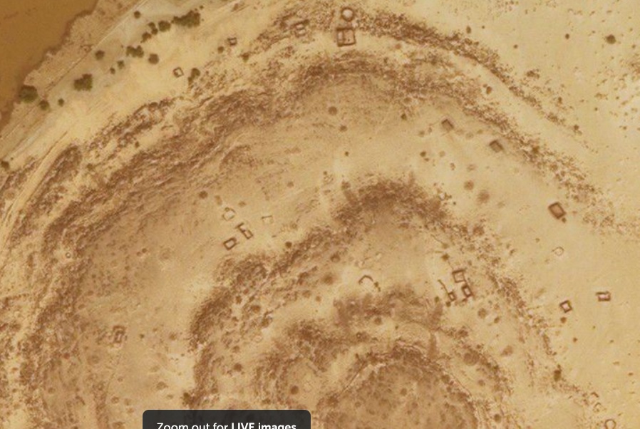
So if this were a quarry you would expect to find "Product" they are pulling out of the hill. Take note, the following image is a very small area of a much larger context. Will post separately.
a reply to: Harte
This image was taken just .8 mile away from what we assume to be a quarry, mine at 100ft height. There are square blocks, round blocks, round objects, barely visible walls around some of these objects. There are also items that appear to be bars of iron, some bent into shapes. On all these points it is acknowledge a physical inspection would be required to confirm this.
One might say, well if we assume these are building blocks, there are not many, so, its immaterial to history and time. And that would be true if, we do not expand the size of the context. It would be settled as a small quarry that put a few blocks out and everyone went home.
So what happens when we expand our view?
The things that would be needed to move, guess, 10 ton blocks? Roads, well defined roads to haul the blocks over. Transport, carts to haul the stones. Power, horses or other large animals (Elephant anyone?) If this were a modern day operation you would see readily the machinery that would be involved, cranes, trucks, large buildings.
The roads in this area are well defined but heavily compromised. Some segments are used by modern vehicles, but many appear to be untouched. Plus, if you follow these roads, they lead to more areas of blocks. Many sections of this road network are missing due to the elements, wind rain, and flooding. The width of the road is of interest. At first these roads appear to have been made by a road grader, bulldozer, but if that were true then the road might have a uniform width, which, they don't. If one were to zoom in on the original quarry image you might note a segment of this road on the upper left at the first "Ring". It runs for 530 ft and disappears on both ends. The amount of roadway and the quality of it would suggest this was not a small operation. If, you follow that road to the WSW it runs for 20 miles! That 20 miles is filled with areas just like the one presented here. If you follow the road in the opposite direction you are presented with a mind boggling number of sites that are even larger.
To touch on the manpower required to operate this quarry, it would easily surpass 10s of thousands, if not more. There are areas in this greater context that clearly show stones were removed.
You, can decide for yourself what to accept as a logical assumption. You may choose to follow a completely different tangent, mindset, conclusion. No problem with that, as long as you are explaining all the elements that are available to view.
As far as recorded history, as far as I know, there are no references to a quarry/ mine of this capacity, size, in this part of the world. You are free to correct me in that. Otherwise, I conclude that the final order of these building materials, was canceled abruptly. And, permanently lol
Because of the areas involved and sheer amount of "Blocks" it is prohibitive to share them here.
zoom.earth...=19.877555,-13.478952,12z
If I haven't said it before, I thank all who have taken part in this exercise, exploration, for the truth, detractor or otherwise. The truth is out there, all you have to do, is look for it
ADDED NOTE: It appears this are has been occupied off and on for quite some time. At present a very minimum amount of occupants.
edit on
PMMondayMonday thAmerica/ChicagoAmerica/Chicago0985 by All Seeing Eye because: (no reason given)
If all that's true, then I'd say it either isn't a quarry or it's a quarry that's not associated with the objects in your last pic - whatever they
are.
Harte
Harte
originally posted by: Harte
If all that's true, then I'd say it either isn't a quarry or it's a quarry that's not associated with the objects in your last pic - whatever they are.
Harte
Again, considering my beloved ATS, I have to throttle back the images I post. And once again, you, have to look for yourself.
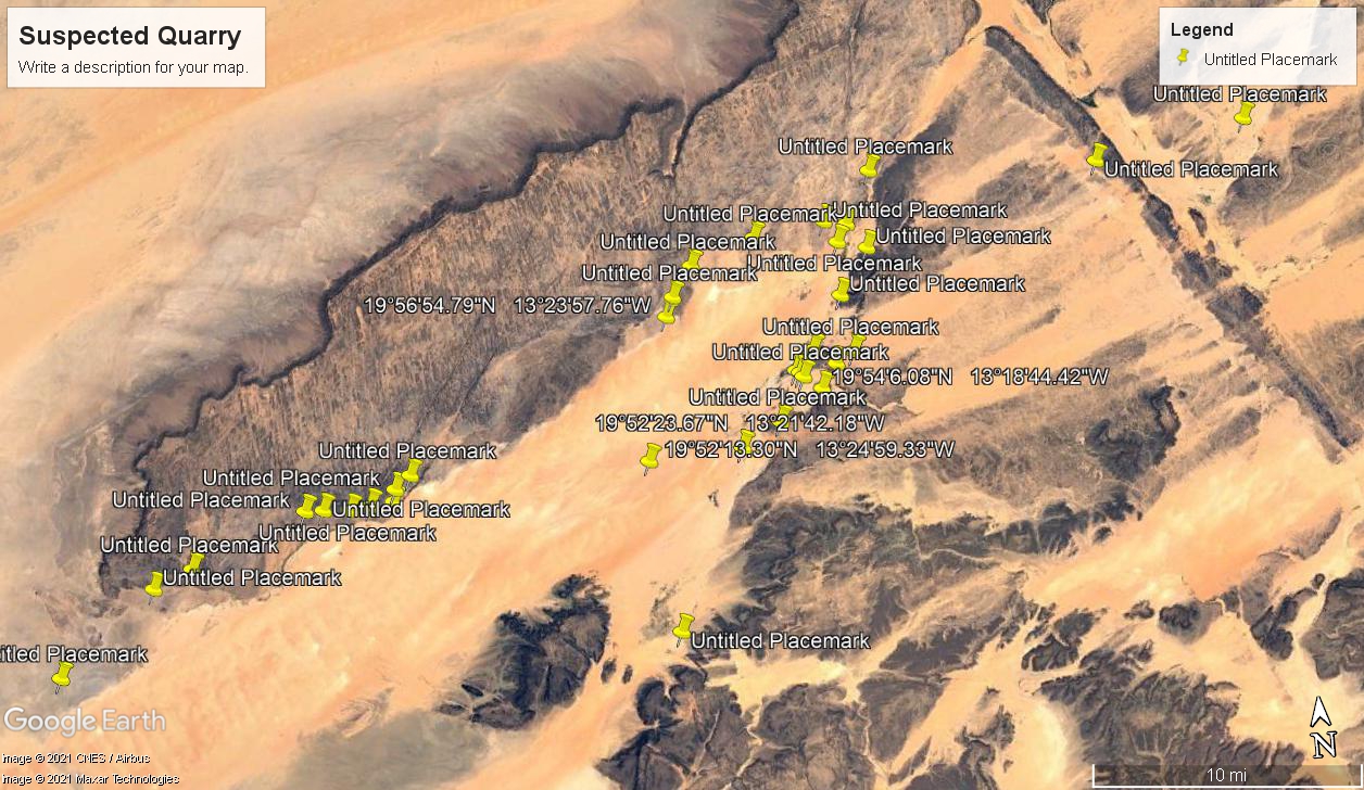
If you go to 19°52'23.67"N 13°21'42.18"W you will find another area very similar to the first image at 19°56'54.79"N 13°23'57.76"W. You will see a "Stepped" sequence that follows the veins of broken rock that goes around the feature. If you go to the north, approx 355deg 650ft, you will find 4 objects that appear to be man made. From the image you can see these stepped areas are not normal compared to some of the other hills in the area. example 19°54'6.08"N 13°18'44.42"W This hill appears to have had no mining on it. You will also note at the top, there are are naturally self liberating stones just sitting there. You can use that to compare.
I believe it vary logical, in fact, base logic, that if a human is involved in some process it must involve the environment it is found in. In this case it looks like the hill was quarried in a very primitive manner (No cranes, machines).
Can you explain why you don't think stone blocks are involved, or associated, when virtually the whole area appears to be filled with them. Do you see something that would disassociate those blocks from the Quarry? Share your logic.
zoom.earth...=19.874401,-13.362148,18z
satellites.pro...,-13.361564,17
edit on PMMondayMonday thAmerica/ChicagoAmerica/Chicago0788 by All Seeing Eye because: (no reason given)
a reply to: Harte
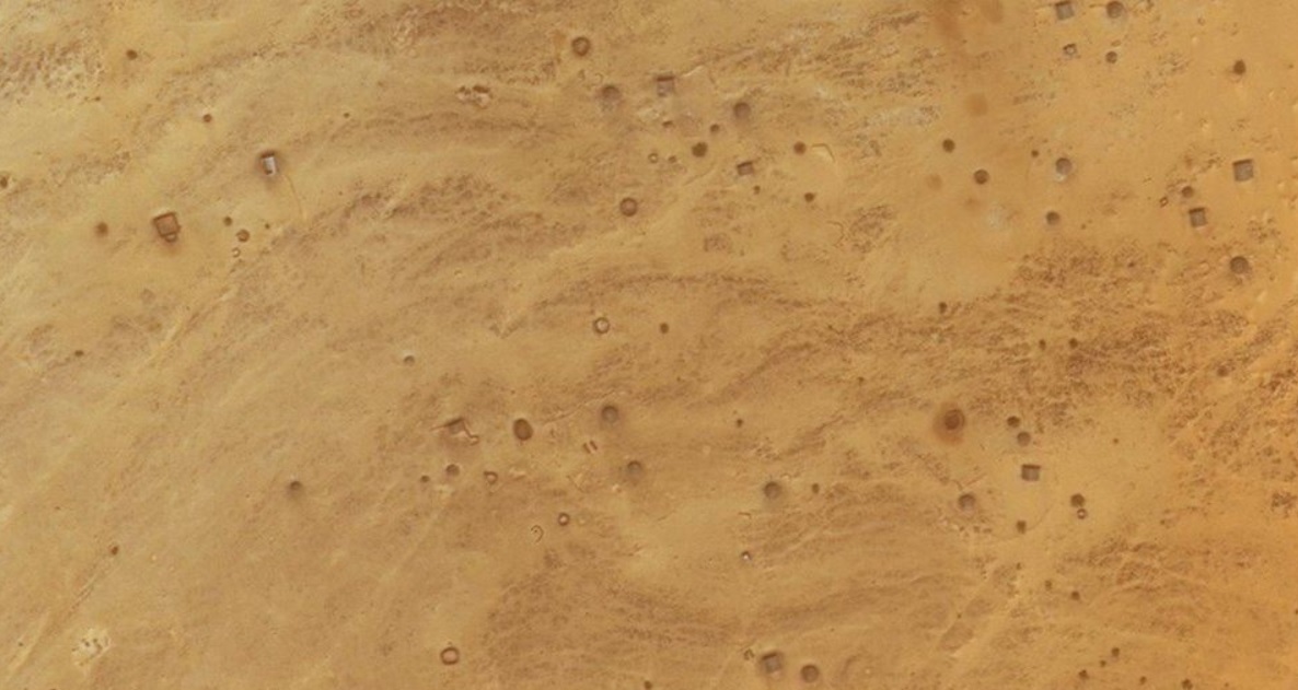
Concerning the blocks. They are not all blocks. There seems to be a reoccurring pattern within these areas. You will have blocks of various sizes, shapes. But, it seems that there are other types of, items.
These "Items" are generally the same size as the blocks, but, hollow. They are scattered within the area. Circular ones, square ones, and even some with unique patterns in them. One stone even had this "Ring" around one of the stones, circular.
Some seem to have a bottom and others seem open on the bottom.
Not knowing what these "Items" are, I would think, suggest, they are some sort of tool to shape the stones. Don't ask me how. I prefer not to go there.
originally posted by: All Seeing Eye
a reply to: Byrd
Well, good for you
Now sink your teeth into this, what do you see. No coaching from me, no peer pressure. Then at the same time try to figure out how many death's were involved with its history. Admittedly, it might be difficult for you, because you have to force yourself to look.
Zoom in real close.
zoom.earth...=19.948915,-13.399377,18z
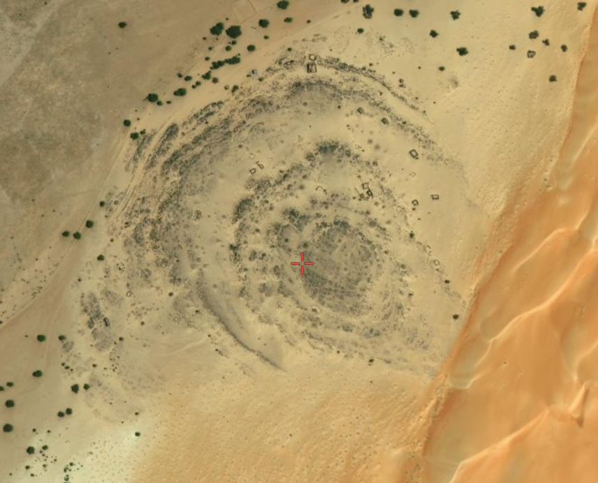
Several huts (dating to the 1800's - 1900's, judging from the lack of modern roads and the condition of the houses) and an open pit mine structure with some processing areas. Possibly for salt (judging from the white residue), though other resources are also likely.
Looks as if it was used and then abandoned (or unused) several times with people coming back to build newer structures rather than repairing and reusing older ones. It doesn't appear to have been used in the past 20 years or so, or if used, was used by nomadic peoples and not anyone else.
Deaths? No telling. This doesn't look like a large-scale operation since the buildings aren't clustered (as you would have with administrative offices, barracks, etc.
re-link of image
What were you expecting me to see?
edit on 10-8-2021 by Byrd because: (no reason given)
originally posted by: Harte
If you like spending time poring over satellite pics looking for stuff, there's a site out there somewhere that lets you examine satellite photos zoomed in (about one square meter at a time) to see if you can identify anything that looks like stone tools. It covers a large area and for each pic, you check a few boxes on a checklist and move on to the next pic. There are no "wrong" answers, it's a team that's genuinely trying to find spots in that region to investigate (excavate, I presume) in some area somewhere - might be Africa.
I feel certain that whatever it is/was, it is/was a Zooniverse project. That's typical of the setup for their citizen science projects.
originally posted by: All Seeing Eye
a reply to: Harte
To compare the first image against this one. To the left is a block, to the right look at the patterns in the stone. These hills in this area and others have this same pattern. They are a natural source for large building blocks.
We agree, this area is a quarry.
Sorry, but that's a dreadful image quality.
The thing on the left isn't a block. It's a depression. It doesn't appear to be a quarry.
originally posted by: All Seeing Eye
If you go to 19°52'23.67"N 13°21'42.18"W you will find another area very similar to the first image at 19°56'54.79"N 13°23'57.76"W.
That's geology (Taoudeni belt overlying the West African Craton), and a very nice example that shows how desert erosion can define layers (greenstone layers and gneiss layers, I believe) in the rock. The beds are deformed and shifted due to mountain building... if I'm not mistaken that's the area where the Taoudeni and the basement rocks of the West African Craton meet.
You will see a "Stepped" sequence that follows the veins of broken rock that goes around the feature. If you go to the north, approx 355deg 650ft, you will find 4 objects that appear to be man made.
Don't see it, frankly.
Can you explain why you don't think stone blocks are involved, or associated, when virtually the whole area appears to be filled with them. Do you see something that would disassociate those blocks from the Quarry? Share your logic.
zoom.earth...=19.874401,-13.362148,18z
satellites.pro...,-13.361564,17
Seriously, it's gneiss and greenstone belts from the Craton. it's geology. Lovely geology. You get all kinds of fun and weird stuff going on with rocks. like this collapsed dome or this pair in the Sahara
For anyone interested in a little "eyeball training" in geology, a set of pretty detailedflashcards on basic geology. Goes into a lot o concepts over the whole series
edit on 10-8-2021 by Byrd because: (no reason given)
originally posted by: Byrd
originally posted by: All Seeing Eye
a reply to: Harte
To compare the first image against this one. To the left is a block, to the right look at the patterns in the stone. These hills in this area and others have this same pattern. They are a natural source for large building blocks.
We agree, this area is a quarry.
Sorry, but that's a dreadful image quality.
The thing on the left isn't a block. It's a depression. It doesn't appear to be a quarry.
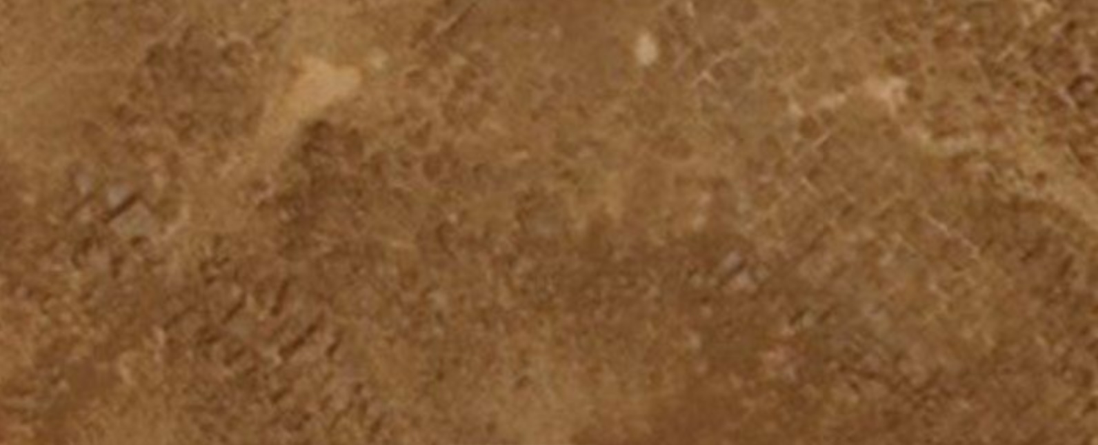
Here is a zoomed image of that particular, specific, stone.
If, it were a depression the shadow would be on the other side. The irregular rocks to the right are all above ground and the shadows are all on the same side. It is not a depression, the object is sitting, on the surface.

originally posted by: Byrd
originally posted by: All Seeing Eye
If you go to 19°52'23.67"N 13°21'42.18"W you will find another area very similar to the first image at 19°56'54.79"N 13°23'57.76"W.
That's geology (Taoudeni belt overlying the West African Craton), and a very nice example that shows how desert erosion can define layers (greenstone layers and gneiss layers, I believe) in the rock. The beds are deformed and shifted due to mountain building... if I'm not mistaken that's the area where the Taoudeni and the basement rocks of the West African Craton meet.
You will see a "Stepped" sequence that follows the veins of broken rock that goes around the feature. If you go to the north, approx 355deg 650ft, you will find 4 objects that appear to be man made.
Don't see it, frankly.
Can you explain why you don't think stone blocks are involved, or associated, when virtually the whole area appears to be filled with them. Do you see something that would disassociate those blocks from the Quarry? Share your logic.
zoom.earth...=19.874401,-13.362148,18z
satellites.pro...,-13.361564,17
Seriously, it's gneiss and greenstone belts from the Craton. it's geology. Lovely geology. You get all kinds of fun and weird stuff going on with rocks. like this collapsed dome or this pair in the Sahara
For anyone interested in a little "eyeball training" in geology, a set of pretty detailedflashcards on basic geology. Goes into a lot o concepts over the whole series
You seem to have overlooked the man made objects present on these levels. You really need to keep the context that is presented. I just cant imagine someone dragging these very large objects up a hill and setting them there for no reason. I doubt they would do this out of sheer boredom. You cant just look the other way. You have to address everything that is present.
Otherwise, you are doing "science" a dis-justice.
a reply to: Byrd
This entire site, is over 20 square miles. I want you to see the extensive road network. The massive amounts of stone just laying there. Some places the density is unbelievable. These sites are all tied together by that road network, that has been compromised by, time.
20 years? Well, that's a start.
No modern vehicles present in that 20 Sq miles. There is a radio tower that is in the area, but that is no reason to have all these well defined roads. There are tire tracks, well driven, but not one human being seen, but, in saying that, there are many examples of humans present, putting white tarps over something in the ground, in many places. There are orange "tags" on several of the sites. There are white tags in a few locations painted on the ground. Recently, one area had a "trailer" brought in. I have seen no indications of Nomad tents, you can tell the difference. These things are indicative of a servery being conducted. And who would be doing that? Not you, not me, but, there are boots on the ground in this area, they left their marks.
Admittedly, it takes time to address all the elements that are seen. Yes, there are buildings seen in the area, yes the French may have had a presents, and yes, Mauritania may in fact be conducting a servery, with no public release. And yes, there is nothing in the history books. That in itself would suggest, this site may in fact, be prehistoric.
"But their not building blocks". Let the reader decide for themselves.
And I have to admit, one site in particular, has me frightened. I just don't want to discuss it.
For anyone interested in viewing this area it is centered on 19°52'13.30"N 13°24'59.33"W
Again its a massive site, all connected by road.
What were you expecting me to see?
This entire site, is over 20 square miles. I want you to see the extensive road network. The massive amounts of stone just laying there. Some places the density is unbelievable. These sites are all tied together by that road network, that has been compromised by, time.
20 years? Well, that's a start.
No modern vehicles present in that 20 Sq miles. There is a radio tower that is in the area, but that is no reason to have all these well defined roads. There are tire tracks, well driven, but not one human being seen, but, in saying that, there are many examples of humans present, putting white tarps over something in the ground, in many places. There are orange "tags" on several of the sites. There are white tags in a few locations painted on the ground. Recently, one area had a "trailer" brought in. I have seen no indications of Nomad tents, you can tell the difference. These things are indicative of a servery being conducted. And who would be doing that? Not you, not me, but, there are boots on the ground in this area, they left their marks.
Admittedly, it takes time to address all the elements that are seen. Yes, there are buildings seen in the area, yes the French may have had a presents, and yes, Mauritania may in fact be conducting a servery, with no public release. And yes, there is nothing in the history books. That in itself would suggest, this site may in fact, be prehistoric.
"But their not building blocks". Let the reader decide for themselves.
And I have to admit, one site in particular, has me frightened. I just don't want to discuss it.
For anyone interested in viewing this area it is centered on 19°52'13.30"N 13°24'59.33"W
Again its a massive site, all connected by road.
new topics
-
Elon's Starlink Stole The Election For Trump--Leftist Conspiracy Theorists Charge
General Conspiracies: 2 hours ago -
Speaker Johnson Orders Entire Biden Administration to Preserve and Retain All Records - Documents
US Political Madness: 3 hours ago -
Resident Plane enthusiasts needed weird noise
General Chit Chat: 6 hours ago -
Fired FEMA Employee Says It Was Not ‘Isolated’ Incident: ‘Colossal Event Of Avoidance’
US Political Madness: 9 hours ago -
Australia has been holding out on us
Music: 9 hours ago
top topics
-
Fired FEMA Employee Says It Was Not ‘Isolated’ Incident: ‘Colossal Event Of Avoidance’
US Political Madness: 9 hours ago, 23 flags -
Speaker Johnson Orders Entire Biden Administration to Preserve and Retain All Records - Documents
US Political Madness: 3 hours ago, 16 flags -
Elon's Starlink Stole The Election For Trump--Leftist Conspiracy Theorists Charge
General Conspiracies: 2 hours ago, 14 flags -
Resident Plane enthusiasts needed weird noise
General Chit Chat: 6 hours ago, 4 flags -
Australia has been holding out on us
Music: 9 hours ago, 3 flags
active topics
-
Russia Ukraine Update Thread - part 3
World War Three • 6766 • : tomeville -
Fired FEMA Employee Says It Was Not ‘Isolated’ Incident: ‘Colossal Event Of Avoidance’
US Political Madness • 34 • : AlroyFarms -
Elon's Starlink Stole The Election For Trump--Leftist Conspiracy Theorists Charge
General Conspiracies • 19 • : burntheships -
President-Elect DONALD TRUMP's 2nd-Term Administration Takes Shape.
Political Ideology • 131 • : xuenchen -
Let's Talk About Vivek (Because No One Wants To)
2024 Elections • 133 • : TzarChasm -
Speaker Johnson Orders Entire Biden Administration to Preserve and Retain All Records - Documents
US Political Madness • 20 • : Lumenari -
President-Elect Donald Trump will Meet with Coup-Victim JOE BIDEN on Wed 11.13.2024.
2024 Elections • 16 • : WeMustCare -
60s-70s Psychedelia
Music • 49 • : anthelion -
Election statistics question
2024 Elections • 20 • : chr0naut -
Trump Portrait Ended Better Than Expected--WATCH THIS
2024 Elections • 13 • : CarlLaFong