It looks like you're using an Ad Blocker.
Please white-list or disable AboveTopSecret.com in your ad-blocking tool.
Thank you.
Some features of ATS will be disabled while you continue to use an ad-blocker.
share:
reply to post by lasertaglover
That deep Russian quake on the China border . . .
seems reasonably powerful.
How precedented is that?
Any above average implications?
IIRC, that's not far off from the length of Colorado top to bottom.
How many quakes in an average year are that deep or deeper?
IT just seems very curious to me, for some reason.
Any added info would be appreciated.
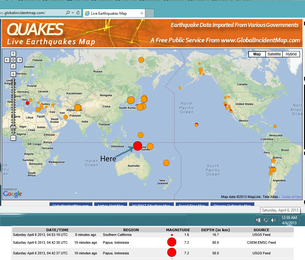
7.2 just slammed P.N.G./Indonesia
comcat.cr.usgs.gov...
I thought it was less...watched it come in.
58 km deep, initial reports....there will probably be changes on this is my guess.
Note: that is Mi (moment) magnitude...
Yep, mag already dropped once, now down to 7.1- although that is now Mwp magnitude.
comcat.cr.usgs.gov...
I thought it was less...watched it come in.
58 km deep, initial reports....there will probably be changes on this is my guess.
edit on Fri Apr 5th 2013 by TrueAmerican because: (no reason
given)
Note: that is Mi (moment) magnitude...
edit on Sat Apr 6th 2013 by TrueAmerican because: (no reason given)
Yep, mag already dropped once, now down to 7.1- although that is now Mwp magnitude.
edit on Sat Apr 6th 2013 by TrueAmerican because: (no
reason given)
Good thing it's distanced from any cities.
edit on 6/4/13 by Lothbrok because: (no reason given)
reply to post by TrueAmerican
Thanks for the heads up! I was just there like 1/2 hr ago.. and missed it.
Pic:

Thanks for the heads up! I was just there like 1/2 hr ago.. and missed it.
Pic:

LMAO.

Even the NEIC itself doesn't know what kind of magnitude it is:

earthquake.usgs.gov...
And that's now 7.0 Unknown Magnitude. So if the magnitude type is unknown, then WTF? How can that even be at all? It MUST be SOME KIND of magnitude!!!
Quick go look before they change it...but I captured a screenie of it before they could.
So if they don't, how the heck are we supposed to know?
:shk:
They gotta come up with a better way, I swear. Ok look, it was a 6.7 to 7.2 ATS magnitude. Ok? The fricken end of this BS!

Even the NEIC itself doesn't know what kind of magnitude it is:

earthquake.usgs.gov...
And that's now 7.0 Unknown Magnitude. So if the magnitude type is unknown, then WTF? How can that even be at all? It MUST be SOME KIND of magnitude!!!
Quick go look before they change it...but I captured a screenie of it before they could.
So if they don't, how the heck are we supposed to know?
:shk:
They gotta come up with a better way, I swear. Ok look, it was a 6.7 to 7.2 ATS magnitude. Ok? The fricken end of this BS!
edit on Sat Apr 6th
2013 by TrueAmerican because: (no reason given)
edit on Sat Apr 6th 2013 by TrueAmerican because: (no reason given)
reply to post by BO XIAN
E. RUSSIA-N.E. CHINA BORDER REG.
I'm still getting my head around their databases, not sure which one to use to search for info.
this is from the China Earthquake Networks Center catalog 1970-2012
lat 40 to 45.32, long 128.1 to 135.72
results show 1971/06/06 to 2011/05/10
of 141 events on that list/map
60 over 500km deep
interactive map
text list
hopefully the popup tags work for you, some of them didn't when I looked.
edit on 6-4-2013 by muzzy because: (no reason given)
Watch Hekla volcano
Katla Hekla
2nd line
Katla Hekla
2nd line
edit on 6-4-2013 by triplereiki because: (no reason given)
Anything going on in that area?
I saw on my map but disappeared....glitch or maybe a timeout
anyone beginning to see a pattern of displacement?
I saw on my map but disappeared....glitch or maybe a timeout
anyone beginning to see a pattern of displacement?
edit on 6-4-2013 by triplereiki because: (no reason given)
Why evacuate for an earthquake no-one can feel?
It's four years since the deadly earthquake in L'Aquila, Italy, and six months since scientists were convicted of manslaughter for failing to communicate the danger. Today, evacuation orders are issued much more readily - too readily, some say.
"Everyone knows, you can't predict an earthquake."
Anne Thornley-Bennett, who lives in the Italian town of Barga, categorically believes this. So why, on 31 January, did she decide to evacuate when the local council sent out warnings of a major quake?
"We received dozens of phone calls and text messages, one of which just said, 'Evacuate'. We just went along with the mania," she sighs.
www.bbc.co.uk...
More at link
Rainbows
Jane
I must be the only one awake this early...
There has been a 7.1 quake in Papua Indonesia (downgraded on the USGS site to 7.0) about 6 hours ago, followed by several aftershocks. The main quake is at the bottom of the list.
Note that, for newbies to this thread, the page automatically updates, so the farther from the time of this post the lower on the page the events listed below will be, until at the 7 day mark they drop off altogether.
SOURCE - USGS
MAP 4.7 2013/04/06 10:04:11 -3.468 138.447 86.0 PAPUA, INDONESIA
MAP 4.6 2013/04/06 09:34:13 -9.905 -75.487 45.1 CENTRAL PERU
MAP 4.6 2013/04/06 08:49:29 -8.828 -78.654 77.6 NEAR THE COAST OF NORTHERN PERU
MAP 3.1 2013/04/06 08:02:30 58.361 -154.460 186.1 ALASKA PENINSULA
MAP 5.2 2013/04/06 07:50:31 -3.523 138.432 71.1 PAPUA, INDONESIA
MAP 4.8 2013/04/06 07:37:55 1.650 127.458 136.0 HALMAHERA, INDONESIA
MAP 4.7 2013/04/06 06:56:50 -3.723 152.064 8.4 NEW IRELAND REGION, PAPUA NEW GUINEA
MAP 2.5 2013/04/06 06:46:19 36.043 -117.862 1.8 CENTRAL CALIFORNIA
MAP 4.6 2013/04/06 06:20:46 -3.400 138.553 68.3 PAPUA, INDONESIA
MAP 4.1 2013/04/06 05:57:59 -3.522 138.300 70.6 PAPUA, INDONESIA
MAP 2.7 2013/04/06 05:51:30 62.890 -149.565 60.0 CENTRAL ALASKA
MAP 2.6 2013/04/06 05:42:08 19.006 -64.271 19.0 VIRGIN ISLANDS REGION
MAP 2.5 2013/04/06 05:36:48 19.491 -155.030 44.2 ISLAND OF HAWAII, HAWAII
MAP 2.6 2013/04/06 04:48:07 59.393 -153.779 195.1 SOUTHERN ALASKA
MAP 7.0 2013/04/06 04:42:36 -3.526 138.466 68.0 PAPUA, INDONESIA
edit on 6-4-2013 by happykat39 because: added a link
Originally posted by pheonix358
reply to post by happykat39
Um, try the top of this page!
P
OOPS, I am going to claim a senior moment.
reply to post by muzzy
Much appreciate the links. The text list is more functional for me. Particularly for scanning.
It would appear, if I'm reading the list right that many are 500 or so miles deep???!!!
Much appreciate the links. The text list is more functional for me. Particularly for scanning.
It would appear, if I'm reading the list right that many are 500 or so miles deep???!!!
reply to post by BO XIAN
no problem, it was a good question.
yeah lists are better to see the overall picture, I'll do that more often from now but it actually uses more storage space than the kmz file that makes the map (10k for the text and 8k for the kmz) which surprised me.
No the depths are km, we changed to km back in 1970
This is what I put on the Significant Earthquakes 314-2012 page (need to change that heading )
interactive map
China Earthquake Networks gave it a 7.0Ms
gfz conversion table didn't work for this one.
I'm still having trouble with those popups on the maps, some work, some don't, clicking on the side list works sometimes, clicking on the icon works sometimes and vis-versa, not sure what the issue is there
Date/Time: 2013/4/6 04:42:36.12
Lat: -3.526 Long: 138.466 [usgs]
Location: Papua
Magnitude:
Mw 7.0 [gcmt, gfz] Ms 7.0 [gcmt]
mb 6.6 [usgs] 6.8 [gsras] Ms 6.7 [gsras]
Depth: 153.8 km
Deaths: Injuries:
Tsunami:
Catalog Source: gcmt, usgs, ras, gfz
interactive map
China Earthquake Networks gave it a 7.0Ms
gfz conversion table didn't work for this one.
I'm still having trouble with those popups on the maps, some work, some don't, clicking on the side list works sometimes, clicking on the icon works sometimes and vis-versa, not sure what the issue is there
reply to post by TrueAmerican
USGS are getting worse and worse.
I'm just using them for co-ordinates and the phase data now, GCMT for the magnitudes, but GCMT are useless for lat/long, as are LDEO.
its a shambles, and that interactivemapthingy doesn't help as it doesn't have the same data as the 7 days pages links. (no phase data, on that one anyway)
what did the Indonesians have BTW?
I haven't been there for a while since my AV told me to "get the heck outtahere" last time I clicked on the page.
reply to post by angelchemuel
I think the authorities did the right thing, what the article doesn't say is that up to the 31st there were 257 aftershocks from the 5.0mb, 4.8ML quake of 25/01/2013 (which is quite a lot for a "moderate" quake) and based on what happened in the Emilia-Romagna double 5.8, 5.9 series ....................., let alone L'Aquila ............. the chances of another mag 5 were pretty high IMO
garfagnana series
the 5.8ML
the 5.9ML
both together
its always an individuals choice to evacuate anyway, unlike if a Hurricane is coming, its only after a big quake that the authorities have the right to make it compulsory.
a case of damned if they do, damned if they don't at Barga
Prof Stefano Gresta (INGV) is right, building safer houses is the solution, not running away from the problem.
They are building steel frames houses here in NZ that can withstand a magnitude 9.0 quake and timber framed houses since the 1880's have survived mag 7's very well, its anything made of stone that is the problem, no flexibilty. Same in Japan, timber houses ride the wave.
edit on 6-4-2013 by muzzy because: (no reason given)
The event info page lacks an area history, so I don't know how common or uncommon this one is, but it's not in the Pyrenees this time, it's 98
miles from Bern, Switzerland.
3.4 1km SSW of Poisy, France 2013-04-06 16:49:05 45.910°N 6.060°E 2.0
earthquake.usgs.gov...
3.4 1km SSW of Poisy, France 2013-04-06 16:49:05 45.910°N 6.060°E 2.0
earthquake.usgs.gov...
reply to post by muzzy
It does have phase data, on the technical page, and in any event you can get the phase data off my entries after a couple of days once I have caught up!!
Temporary listing of the Indonesia phase data added to the temporary post on my blog.
Found it is now on the USGS page
They also have the moment tensors in the old format since I complained and they emailed to say that they were reinstating them. I hope they don't change their mind!
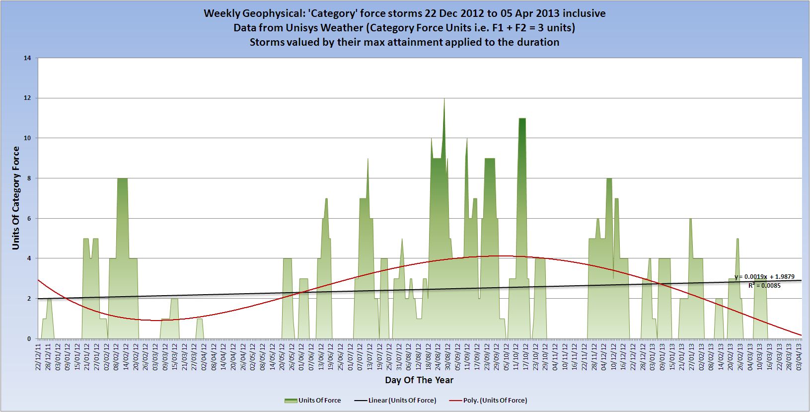
Perhaps a bit OT but I am not sure if your storms thread is still running

]and that interactivemapthingy doesn't help as it doesn't have the same data as the 7 days pages links. (no phase data, on that one anyway)
It does have phase data, on the technical page, and in any event you can get the phase data off my entries after a couple of days once I have caught up!!
Temporary listing of the Indonesia phase data added to the temporary post on my blog.
Found it is now on the USGS page
They also have the moment tensors in the old format since I complained and they emailed to say that they were reinstating them. I hope they don't change their mind!
Perhaps a bit OT but I am not sure if your storms thread is still running

edit on 7/4/2013 by PuterMan because: (no reason given)
new topics
-
Swedish Minister for Gender Equality is Seeking Treatment for Phobia of Bananas
Other Current Events: 2 hours ago -
Satanic ‘Little Season’ of Deception.. Awaken to the Handiwork of the Creator.
ATS Skunk Works: 3 hours ago -
USA-BIDEN and CHINA-Xi Agree Not To Let Artificial Intelligence Decide Nuclear Weapons Use.
World War Three: 3 hours ago -
The mysterious death of Aileen Conway
General Chit Chat: 6 hours ago -
Half-Life 2 is 20 Years Old - its Also Free on Steam until the 18th
Video Games: 10 hours ago
top topics
-
Does the Trump win mean No More Taylor Swift??
Politicians & People: 14 hours ago, 12 flags -
Trump-appointed judge blocks Biden administration overtime rule
Social Issues and Civil Unrest: 16 hours ago, 9 flags -
The mysterious death of Aileen Conway
General Chit Chat: 6 hours ago, 6 flags -
USA-BIDEN and CHINA-Xi Agree Not To Let Artificial Intelligence Decide Nuclear Weapons Use.
World War Three: 3 hours ago, 2 flags -
Satanic ‘Little Season’ of Deception.. Awaken to the Handiwork of the Creator.
ATS Skunk Works: 3 hours ago, 2 flags -
Half-Life 2 is 20 Years Old - its Also Free on Steam until the 18th
Video Games: 10 hours ago, 1 flags -
Swedish Minister for Gender Equality is Seeking Treatment for Phobia of Bananas
Other Current Events: 2 hours ago, 1 flags
active topics
-
The Trump effect 6 days after 2024 election
2024 Elections • 150 • : cherokeetroy -
President-elect TRUMP Picks MATT GAETZ for his ATTORNEY GENERAL - High Level PANIC Ensues.
2024 Elections • 91 • : Xtrozero -
Does the Trump win mean No More Taylor Swift??
Politicians & People • 49 • : JadedGhost -
TODAY IS A HUGE ELECTION DAY FOR AMERICA - November 5th 2024 - Reports from Around The Nation.
2024 Elections • 750 • : WeMustCare -
On Nov. 5th 2024 - AMERICANS Prevented the Complete Destruction of America from Within.
2024 Elections • 156 • : WeMustCare -
President-Elect DONALD TRUMP's 2nd-Term Administration Takes Shape.
Political Ideology • 213 • : WeMustCare -
Satanic ‘Little Season’ of Deception.. Awaken to the Handiwork of the Creator.
ATS Skunk Works • 4 • : NorthOS -
-@TH3WH17ERABB17- -Q- ---TIME TO SHOW THE WORLD--- -Part- --44--
Dissecting Disinformation • 3284 • : 777Vader -
Swedish Minister for Gender Equality is Seeking Treatment for Phobia of Bananas
Other Current Events • 2 • : WeMustCare -
USA-BIDEN and CHINA-Xi Agree Not To Let Artificial Intelligence Decide Nuclear Weapons Use.
World War Three • 5 • : nugget1

