It looks like you're using an Ad Blocker.
Please white-list or disable AboveTopSecret.com in your ad-blocking tool.
Thank you.
Some features of ATS will be disabled while you continue to use an ad-blocker.
share:
reply to post by muzzy
There is Hill Air Force Base there hill Air Force Base They have in the past caused folks around their to jump out of there beds.
There is a interesting article regarding the booms and explosions that have come from this place. And according to another article I read they don't like to own up on stuff.
I am having trouble linking the two articles.
Hill Air Force Base
Here this is it
edit on 11-4-2013 by crappiekat because: to fix link
reply to post by PuterMan
Bazinga!!! Maybe!
First a link to more than you ever needed or wanted to know about Utah's weather!
And definitely more than we ever learned eons ago in geography class!!!
utahweather.org...
I thought the Great Salt Lake Desert meant Utah was all hot.
Turns out I was very wrong! They have four different climate zones...and snow!!!
Who Knew? Not me! This is why I love ATS!!! Tangents...LOTS of tangents!!!
But then I found this:
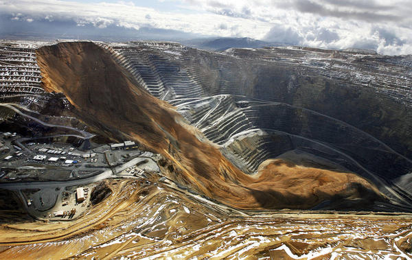
Link to a 'massive' slide at Bingham Canyon Mine.
www.abc4.com...
If Muzzy's link to LDEO uses UTC, this might be it.
Their times listed: 3:31 & 5:05.
Utah's time is UTC -6 if I did it right!
Sooo...that would make it 9:31 & 11:05?
I think the article said it happened at 9:30.
LDEO coordinates: 40.75 & 111.75.
Ones from search of mine info: 40.52 & 112.15.
This one is a link to neat info on the mine, that says they would not be opening
the Visitors Center & overlook plaza on April 1 due to geotechnical movement,
(could they mean geotectonic?) over the winter. REALLY good thing they didn't!!!
www.utahoutdooractivities.com...
The mine is one of only two manmade objects on earth that can be seen from space!
The other one is the Great Wall of china.
Which could explain why we Americans weren't all over it!!!
Nothing to see here folks, move along!
WOQ
reply to post by wasobservingquietly
Wow. Good sleuthing!!!!
Yup a slide would also produce this signal. I knew it was not an earthquake but it was difficult to find the right seismo to see what it was. After posting some of the others showed a clearer 'slide' (as I now know it to be) on the N and E channels rather than the Z channel. We tend to look at Z most of the time but for an event like this the other channels tell a tale.
I take it then that the great salt lake is not a lake?? Looks like one on Google Earth!
ETA: Just had a thought. This may turn up on the mines listing, but probably not until tomorrow. I will take a look and see.
edit on 12/4/2013 by PuterMan because: (no reason given)
reply to post by wasobservingquietly
yes the times on LDEO are UTC.
Bazinga indeed, looks like thats it, LDEO's locations are not usually very accurate, within 50km maybe
great work WOQ
wow thats some landslide!, the Korean's Nuke explosions were only mag 4.8
yes the times on LDEO are UTC.
Bazinga indeed, looks like thats it, LDEO's locations are not usually very accurate, within 50km maybe
great work WOQ
wow thats some landslide!, the Korean's Nuke explosions were only mag 4.8
edit on 12-4-2013 by muzzy because: (no reason given)
2013-04-12 20:33:00, 34.400, 134.800, 6.0, 10.0, Awajishima Fukin
Just in from JMA. Probably not Mag 6 once the main providers have played with it.
Since I lived in Osaka and my girlfriend lives there, I really hope it was not felt there... but a friend of mine wrote me she is crying and affraid
Magnitude 6.0 - Near The South Coast Of Western Honshu. Japan
Location in Google Maps
- Date-Time: Friday, April 12, 2013 @ 20:33:16 UTC
- Earthquake location: 34.413°N, 134.827°E,
- Earthquake depth: 5.3 km
- Distances:
9km (5mi) NW of Sumoto, Japan
20km (12mi) NNE of Fukura, Japan
28km (17mi) SSW of Akashi, Japan
32km (19mi) NE of Naruto, Japan
465km (288mi) WSW of Tokyo, Japan
- Event ID: usb000g5yg
Derived from Event Data Source: USGS
Powered by QVSData
Reached my girlfriend, she is reporting it was pretty strong in Osaka. They all get shocked since it is not normal to feel earthquakes there. But as
far as she knows, there are not reports of injries and accidents so far
edit: and some of my friends are suprised that it was only one quake, they are saying it felt like 2 or more. Seemed very long for them. does somebody have reading of this quake already?
edit: and some of my friends are suprised that it was only one quake, they are saying it felt like 2 or more. Seemed very long for them. does somebody have reading of this quake already?
edit on 12-4-2013 by aLLeKs because: (no reason given)
reply to post by aLLeKs
It has been dropped to 5.7/5.8 by the main providers now.
Just looking up a seismo for you.
Here you are: INU.G.00.BHZ.2013.102
Looks like only one quake.
And another one: JNU.JP..BHZ.2013.102
Still only looks like one.
There are several smaller aftershocks however
It has been dropped to 5.7/5.8 by the main providers now.
Just looking up a seismo for you.
Here you are: INU.G.00.BHZ.2013.102
Looks like only one quake.
And another one: JNU.JP..BHZ.2013.102
Still only looks like one.
There are several smaller aftershocks however
Prov,Date/Time UTC,Latitude,Longitude,Magnitude,Depth(Km),Location
jma,2013-04-12 20:33:00, 34.400, 134.800, 6.0, 10.0, Awajishima Fukin
jma,2013-04-12 20:41:00, 34.400, 134.900, 3.8, 10.0, Osaka-Wan
jma,2013-04-12 21:05:00, 34.400, 134.800, 2.7, 10.0, Awajishima Fukin
jma,2013-04-12 21:09:00, 34.500, 134.800, 3.2, 10.0, Harima-Nada
jma,2013-04-12 21:17:00, 34.400, 134.800, 3.2, 10.0, Awajishima Fukin
jma,2013-04-12 21:23:00, 34.400, 134.800, 3.0, 10.0, Awajishima Fukin
jma,2013-04-12 21:31:00, 34.400, 134.800, 3.4, 10.0, Awajishima Fukin
edit on 12/4/2013 by PuterMan because: (no reason given)
My friend in Osaka just emailed me, said they are ok, said don't panic when you hear about quake, everythings ok.
edit on 12-4-2013 by
AlexanderM because: (no reason given)
reply to post by PuterMan
Thanks for the linking to the photos. The scale of the images is awe-inspiring. Seeing those dump trucks half-buried in the dirt was nearly incomprehensible for my brain which kept trying to compare them to Tonka toy trucks.
Thanks for the linking to the photos. The scale of the images is awe-inspiring. Seeing those dump trucks half-buried in the dirt was nearly incomprehensible for my brain which kept trying to compare them to Tonka toy trucks.
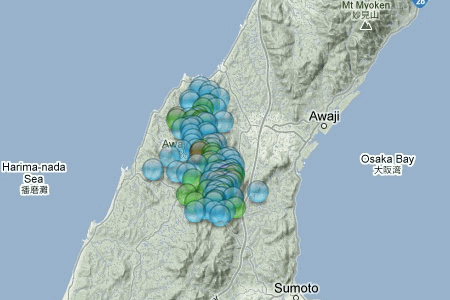
6.3ML, Awaji Island, Osaka Bay, Near S. Coast Of Western Honshu, Japan
interactive aftershocks map, data from NIED
[color=lime](click image for interactive map, opens in new tab/window)
Aqua showing 5.7Mw
status at 5:11 hours after the main shock
mag6= 1
mag5= 0
mag4= 1
mag3= 5
mag2= 26
mag1= 76
total= 109
TTNT= 42,526.867
interactive aftershocks map, data from NIED
[color=lime](click image for interactive map, opens in new tab/window)
Aqua showing 5.7Mw
status at 5:11 hours after the main shock
mag6= 1
mag5= 0
mag4= 1
mag3= 5
mag2= 26
mag1= 76
total= 109
TTNT= 42,526.867
reply to post by aLLeKs
is that island some kind of holiday resort?
looks like it with all the lakes and roads running everywhere
are you still in Osaka? you have your address on your profile as there
is that island some kind of holiday resort?
looks like it with all the lakes and roads running everywhere
are you still in Osaka? you have your address on your profile as there
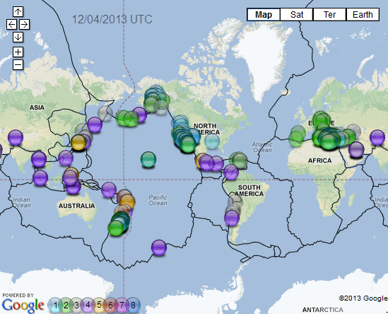
here is a World map I created using P'mans QVS Data Pro program for all the quakes it can gather together at the moment.
as it says, 12/04/2013 UTC
[color=lime](click image for interactive map, opens in new tab/window)
of course these are just some of the networks, at the moment coverage is by
USGS
EMSC
GEONET
GEOAU
GFZ
NOA
CAN
JMA
BGS
I heard a whisper that
CHILE
IRAN
ICELAND
SPAIN
are soon to be added
when you play around with the interactive version you may see that some icons are darker than others, this is where there are a few versions of the same event, just click through using the "next"
ach its already better than that globalincidentmap and that other usgsinteractivemapthingy as it is
edit on 13-4-2013 by muzzy because: i
had a summary of the number of quakes, but of course with multiple network estimates of the same events that is useless
Originally posted by muzzy
reply to post by aLLeKs
is that island some kind of holiday resort?
looks like it with all the lakes and roads running everywhere
are you still in Osaka? you have your address on your profile as there
At the moment I am in Germany, but my heart is still in Osaka and I will move back there as soon as possible.
I don't know about this island as a holiday resort I only know it as the way to Shikoku which in fact is a place of rest for many people from the Kansai region since it is really green and not like the Kansai area.
edit on 13-4-2013 by aLLeKs because: (no reason given)
This one is odd!
Locat ion in Google Maps
Derived from Event Data Source: USGS
Powered by QVSData
GFZ say 5.5, EMSC say 6.0 and the two USGS moment tensors say 6.0
Magnitude 5.8 - Vanuatu
Locat ion in Google Maps
- Date-Time: Saturday, April 13, 2013 @ 22:49:49 UTC
- Earthquake location: 19.110°S, 169.621°E,
- Earthquake depth: 265.9 km
- Distances:
61km (37mi) NE of Isangel, Vanuatu
205km (127mi) SE of Port-Vila, Vanuatu
317km (196mi) NE of We, New Caledonia
471km (292mi) NE of Dumbea, New Caledonia
472km (293mi) NE of Mont-Dore, New Caledonia
- Event ID: usb000g6it
Derived from Event Data Source: USGS
Powered by QVSData
GFZ say 5.5, EMSC say 6.0 and the two USGS moment tensors say 6.0
new topics
-
Swedish Minister for Gender Equality is Seeking Treatment for Phobia of Bananas
Other Current Events: 4 hours ago -
Satanic ‘Little Season’ of Deception.. Awaken to the Handiwork of the Creator.
ATS Skunk Works: 5 hours ago -
USA-BIDEN and CHINA-Xi Agree Not To Let Artificial Intelligence Decide Nuclear Weapons Use.
World War Three: 5 hours ago -
The mysterious death of Aileen Conway
General Chit Chat: 8 hours ago
top topics
-
Does the Trump win mean No More Taylor Swift??
Politicians & People: 16 hours ago, 12 flags -
The mysterious death of Aileen Conway
General Chit Chat: 8 hours ago, 6 flags -
USA-BIDEN and CHINA-Xi Agree Not To Let Artificial Intelligence Decide Nuclear Weapons Use.
World War Three: 5 hours ago, 3 flags -
Satanic ‘Little Season’ of Deception.. Awaken to the Handiwork of the Creator.
ATS Skunk Works: 5 hours ago, 3 flags -
Swedish Minister for Gender Equality is Seeking Treatment for Phobia of Bananas
Other Current Events: 4 hours ago, 3 flags -
Half-Life 2 is 20 Years Old - its Also Free on Steam until the 18th
Video Games: 12 hours ago, 1 flags
active topics
-
Does the Trump win mean No More Taylor Swift??
Politicians & People • 50 • : bluesman023 -
The Trump effect 6 days after 2024 election
2024 Elections • 150 • : cherokeetroy -
President-elect TRUMP Picks MATT GAETZ for his ATTORNEY GENERAL - High Level PANIC Ensues.
2024 Elections • 91 • : Xtrozero -
TODAY IS A HUGE ELECTION DAY FOR AMERICA - November 5th 2024 - Reports from Around The Nation.
2024 Elections • 750 • : WeMustCare -
On Nov. 5th 2024 - AMERICANS Prevented the Complete Destruction of America from Within.
2024 Elections • 156 • : WeMustCare -
President-Elect DONALD TRUMP's 2nd-Term Administration Takes Shape.
Political Ideology • 213 • : WeMustCare -
Satanic ‘Little Season’ of Deception.. Awaken to the Handiwork of the Creator.
ATS Skunk Works • 4 • : NorthOS -
-@TH3WH17ERABB17- -Q- ---TIME TO SHOW THE WORLD--- -Part- --44--
Dissecting Disinformation • 3284 • : 777Vader -
Swedish Minister for Gender Equality is Seeking Treatment for Phobia of Bananas
Other Current Events • 2 • : WeMustCare -
USA-BIDEN and CHINA-Xi Agree Not To Let Artificial Intelligence Decide Nuclear Weapons Use.
World War Three • 5 • : nugget1


