It looks like you're using an Ad Blocker.
Please white-list or disable AboveTopSecret.com in your ad-blocking tool.
Thank you.
Some features of ATS will be disabled while you continue to use an ad-blocker.
share:
reply to post by muzzy
I hear you on that one!!
I want to set up a private, i.e. non-government funded, seismo network around the world. Say two stations in each country. How much would that cost? And a couple ofKrays Crays to run the whole shebang with instant reporting and a centralised listing available on the web and
seismograms and datasets from each station available, not for 14 days but for at least 15 years.
Ah dreams!!! Somehow I don't think even the lottery would accomplish that.
what the conclusion really is saying is "we don't need more funding, we just need any kind of funding at all, so I can give up my day job and do this full time
I hear you on that one!!
I want to set up a private, i.e. non-government funded, seismo network around the world. Say two stations in each country. How much would that cost? And a couple of
Ah dreams!!! Somehow I don't think even the lottery would accomplish that.
reply to post by Wrabbit2000
Unfortunately as I pointed out you are lumping areas together that should not be.
As of this point in time this IS a one time sequence of events unlike any that has gone before it in this area. Santa Cruz is NOT an area known for activity far above the global average. Whilst it is active, it is not as active as Vanuatu for example which is part of the same seismic region. Once again you cannot lump PNG and Vanuatu in the same boat, but then I would not expect you to understand that.
If you have studied the seismicity of the period around the 1960 Valparaiso 9.6 Mw you would be aware that whilst there were several large quakes including Prince William Sound there were, according to the records, not much in the way of large aftershock series so not only was it not short of a very active global period but in addition I displayed the data from 1900 specifically to ensure that I was not hiding anything. Perhaps you missed that point in your hurry to attempt to knock me down?
TrueAmerican's qualifications in seismology are what exactly? Phage himself admits that he is not an expert in many of the fields about which he posts. Virtually everyone on ATS uses sourced materials - it is the rules in case you missed that and indeed you cannot learn anything without it comes from a 'source'. Slayer I know nothing about. I did not say I had anything handled. I said that (because I have a database of over 1,000,000 earthquakes and) I spend long hours working with earthquake statistics, then if I say something is unprecedented it is and as I said I am not prone to making such statements lightly as anyone on this thread will tell you.
I do have qualifications in statistics, as a part of Works Management, and many years ago I studied a college course in Geology but was unable to take the exams for personal reasons. Folks on this thread are aware of that factoid.
I am of course quite prepared to defer to your professional knowledge in this area since I assume you are qualified to put me down?
The 8.1 in 2007 (USGS details here as you failed to back up your statement) was right opposite Gizo to the North West of Honaria and (I am guessing) nearly 1000km from Santa Cruz (no I measured it - 973km so not a bad guess) and not in the same seismic region not that this would bother you in order to prove your point.
Yes these sequences do happen. Not it has not happened to this level in recorded history. Of course if you know otherwise then please do demonstrate your professional expertise and put us amateurs straight.
My intent was to note this is one of, if not THE most seismically active area of our planet in recent times. Fear mongering and scaring the crap out of people isn't a hard thing to do with 6's and 7's being tossed like every day events and not slowing down in any appreciable degree.
Unfortunately as I pointed out you are lumping areas together that should not be.
Now if we all run around using words like unprecedented (which is about as scientific as "I guess" for something like this), then people might get the impression this is a one time sequence of events that may hold some major importance beyond simply being a rather above average series of quakes. After all, it comes in an area known for activity FAR above the global average on the best of days or even, years.
As of this point in time this IS a one time sequence of events unlike any that has gone before it in this area. Santa Cruz is NOT an area known for activity far above the global average. Whilst it is active, it is not as active as Vanuatu for example which is part of the same seismic region. Once again you cannot lump PNG and Vanuatu in the same boat, but then I would not expect you to understand that.
(This I can support and with charts going a bit further back than your 1960's examples...after all, that actually stops JUST short of a very active global period...but then, you knew that, huh?)
If you have studied the seismicity of the period around the 1960 Valparaiso 9.6 Mw you would be aware that whilst there were several large quakes including Prince William Sound there were, according to the records, not much in the way of large aftershock series so not only was it not short of a very active global period but in addition I displayed the data from 1900 specifically to ensure that I was not hiding anything. Perhaps you missed that point in your hurry to attempt to knock me down?
"If you say it's unprecedented, it is? Okay.... for the record...if someone like TrueAmerican says that, I sit up and listen. If someone like Phage says that in his area of expertise and focus...I sit up quickly to take notes for my own checking later. If a person like Slayer says that about a well researched project ...I take notice.
Perhaps you also have professional and academic credentials to declare earthquake activity in a very unstable seismic zone to be unprecedented (Or just extensive and ..AHEM...sourced....support) ...but I missed them across the multiple messages basically telling people to pipe down, you have it all handled.
TrueAmerican's qualifications in seismology are what exactly? Phage himself admits that he is not an expert in many of the fields about which he posts. Virtually everyone on ATS uses sourced materials - it is the rules in case you missed that and indeed you cannot learn anything without it comes from a 'source'. Slayer I know nothing about. I did not say I had anything handled. I said that (because I have a database of over 1,000,000 earthquakes and) I spend long hours working with earthquake statistics, then if I say something is unprecedented it is and as I said I am not prone to making such statements lightly as anyone on this thread will tell you.
I do have qualifications in statistics, as a part of Works Management, and many years ago I studied a college course in Geology but was unable to take the exams for personal reasons. Folks on this thread are aware of that factoid.
I am of course quite prepared to defer to your professional knowledge in this area since I assume you are qualified to put me down?
I'll leave ya to it though. I wouldn't want to add anything calming or point out how unremarkable this actually HAS been ....with series in that region, in recent years no less, following similar patterns. (Starting with the 8.1 in April of 2007). It happens....It always has happened...and it will continue to happen. Earth is a wonderful and changing place, isn't it?
The 8.1 in 2007 (USGS details here as you failed to back up your statement) was right opposite Gizo to the North West of Honaria and (I am guessing) nearly 1000km from Santa Cruz (no I measured it - 973km so not a bad guess) and not in the same seismic region not that this would bother you in order to prove your point.
Yes these sequences do happen. Not it has not happened to this level in recorded history. Of course if you know otherwise then please do demonstrate your professional expertise and put us amateurs straight.
edit on 11/2/2013 by PuterMan because: (no reason given)
Originally posted by wujotvowujotvowujotvo
Confounding Sequence of Big Quakes Rattle Santa Cruz Islands pg10
TrueAmerican post 1
www.abovetopsecret.com/forum/thread923000/pg10#pid15901172
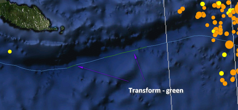
On another note, anyone see any transform faults here?
neic.usgs.gov...
Ahh nope. Purple=subduction zone, green=transform fault, and ahh, I don't see no green. (At least not where others are reporting the northwestern side of that fault to be a transform fault, I don't.)
Just a note to the otherwise wise, making maps.
Olivine
www.abovetopsecret.com/forum/thread923000/pg10#pid15901871
TrueAmerican post 2
www.abovetopsecret.com/forum/thread923000/pg10#pid15902045
Quake Watch 2013 pg39
PuterMan
www.abovetopsecret.com/forum/thread911913/pg39#pid15902678
Thanks for the PDF link Olivine.
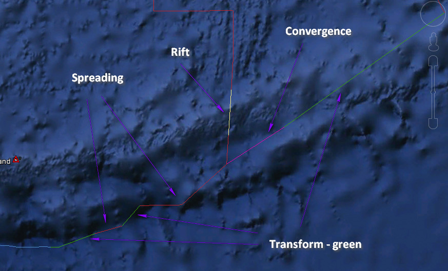
Pretty much confirms my subduction/transform graphic (thank goodness).
Reconcile yourselves, this is not a real dispute... all the points are true and you two reveal a pedagogical problem, not any personal position.
Most disseminated tectonic maps have uninterrupted triangle spikes of subduction.
Historical Seismicity have purple colour.
Only focused maps of the region have the transform.
Combining Olivine's new USGS pdf and slabs help to constrain the boundary zone.
I think I got a bit lost with what you were trying to say.
Here is the northern transform zone (not all transform)

And here is the southern transform zone

Source is USGS via Google Earth.
I tried to include your eloquent post but I would run out of characters....anyway..
Being a very passive aggressive cat by nature, I highly respect your polite and articulate assertiveness in your last post.......this is me a little green with envy!
And how dare WACKYWRABBIT question the Jedi Master
He has quite a pair
Being a very passive aggressive cat by nature, I highly respect your polite and articulate assertiveness in your last post.......this is me a little green with envy!
And how dare WACKYWRABBIT question the Jedi Master
He has quite a pair
These quake smarms are getting crazy.. When will they stop>? Hope everyone stays safe in quake prone areas?
Don't get me wrong, I enjoy TAs threads, because they are a little more exciting, but wrabbit, if you're saying you'll take his, or phages word
when it comes to quakes, you're not reading enough in the FE forum! Puterman and his partner in crime, Muzzy, are the ones in the know when it comes
to this - when PM out of all members says something its unprecedented, THEN you take notice!
reply to post by PuterMan
My notes here have been short, by my standards. I've lumped together little more than the need for perspective and conscious effort in not scaring the stuffing out of people during a time that it's NOT a hard thing to do and with events many already find sensitive for reaction on. That is largely by the media, among other things.
Phage, TrueAmerican and others were mentioned as examples of those who post with quiet confidence and a long history of posting with accurate authority. This specific topic was secondary to the basis for the example.
Anyway.. I said my piece and I appreciate the replies. Lets hope the quakes slow down and fade as they always have. After all, that is what we're all interested in for end result, right? Calm and a return to straight lines.
reply to post by PuterMan
I was a bid struck/odd with the distant "messages" you sent to each other but not replied yet to one another...
My view is that such situations arise because of pedagogical problems and generate needless disagreements, how easily the information is available and from which channels information comes from.
An example to what I mean- your reaction to the study of Australia/India plate breakup released after the offshore Sumatra M8.7~8.6 and M8.2.
The plate-microplates problem is the best parallel that relate to this fault trace/type problem.
There are maps that need urgent updates or notes on the state of present knowledge.
edit on 11-2-2013 by wujotvowujotvowujotvo because: (no
reason given)
CNN reporting that this 4,9 in North korea is close to their nuclear testing site
www.cnn.com... nn_topstories+%28RSS%3A+Top+Stories%29&utm_content=My+Yahoo
Magnitude 4.9 - NORTH KOREA
Date-Time Tuesday, February 12, 2013 at 02:57:51 UTC
Tuesday, February 12, 2013 at 11:57:51 AM at epicenter
Time of Earthquake in other Time Zones
Location 41.299°N, 129.081°E
Depth 1 km (~0.6 mile) (poorly constrained)
Region NORTH KOREA
Distances 24 km (14 miles) ENE of Sungjibaegam, North Korea
34 km (21 miles) WNW of Hau-ri, North Korea
42 km (26 miles) NNW of Kilju, North Korea
51 km (31 miles) WSW of Hoemul-li, North Korea
earthquake.usgs.gov...
The U.S. Geological Survey reported a seismic disturbance in northern North Korea on Tuesday, centered near the site of the secretive regime's two previous nuclear tests.
The area around the reported epicenter of the magnitude 4.9 disturbance has little or no history of earthquakes or natural seismic hazards, according to U.S. Geological Survey maps. The disturbance took place at a depth of about 1 kilometer, the USGS said.
www.cnn.com... nn_topstories+%28RSS%3A+Top+Stories%29&utm_content=My+Yahoo
Magnitude 4.9 - NORTH KOREA
Date-Time Tuesday, February 12, 2013 at 02:57:51 UTC
Tuesday, February 12, 2013 at 11:57:51 AM at epicenter
Time of Earthquake in other Time Zones
Location 41.299°N, 129.081°E
Depth 1 km (~0.6 mile) (poorly constrained)
Region NORTH KOREA
Distances 24 km (14 miles) ENE of Sungjibaegam, North Korea
34 km (21 miles) WNW of Hau-ri, North Korea
42 km (26 miles) NNW of Kilju, North Korea
51 km (31 miles) WSW of Hoemul-li, North Korea
earthquake.usgs.gov...
edit on 11-2-2013 by megabogie because: (no reason given)
Latest one at Solomon Islands is listed as less than a mile deep:
4.9 55km SSW of Lata, Solomon Islands 2013-02-12 03:12:26 11.189°S 165.659°E 1.0km
Is that the shallowest one yet? The 5.8 before that wasn't much deeper:
5.8 51km SW of Lata, Solomon Islands 2013-02-11 20:09:54 11.044°S 165.495°E 2.2km
4.9 55km SSW of Lata, Solomon Islands 2013-02-12 03:12:26 11.189°S 165.659°E 1.0km
Is that the shallowest one yet? The 5.8 before that wasn't much deeper:
5.8 51km SW of Lata, Solomon Islands 2013-02-11 20:09:54 11.044°S 165.495°E 2.2km
reply to post by megabogie
No doubt about it, magnitude, depth, location, seismic history all say nuclear test.
bigger than the last one (first?) was a 4.8 from memory.
No doubt about it, magnitude, depth, location, seismic history all say nuclear test.
bigger than the last one (first?) was a 4.8 from memory.
reply to post by deometer
could be a mistake, the Korean event was right below it, 1.0km also. Thick typing fingers at USGS?
on the Phase Data it says
dep = 1.0 +/- 4.8
so it could have been 5.8km deep or 3.8km in the air !
that other one shows
dep = 2.2 +/- 3.6, so about the same
even 5.8km is very shallow
could be a mistake, the Korean event was right below it, 1.0km also. Thick typing fingers at USGS?
on the Phase Data it says
dep = 1.0 +/- 4.8
so it could have been 5.8km deep or 3.8km in the air !
that other one shows
dep = 2.2 +/- 3.6, so about the same
even 5.8km is very shallow
edit on 12-2-2013 by muzzy because: (no reason given)
GFZ have lost the plot on Santa Cruz
2013-02-11 09:40:22 6.0 10.94°S 166.81°E 10 A MT Santa Cruz Islands
MTS says 5.8Mw geofon.gfz-potsdam.de...
2013-02-11 20:09:55 5.7 10.96°S 165.57°E 10 M MT Santa Cruz Islands
MTS says 5.7Mw geofon.gfz-potsdam.de...
LISS SNZO says the opposite (reverse it)
I think in this case USGS have got it right
5.7 2013/02/11 09:40:24 -11.058 166.736 34.3 SANTA CRUZ ISLANDS
5.8 2013/02/11 20:09:54 -11.044 165.495 2.2 SANTA CRUZ ISLANDS
reply to post by muzzy
So if USGS knows this was a nuke test, why haven't they removed it from the eq list?
So if USGS knows this was a nuke test, why haven't they removed it from the eq list?
reply to post by crappiekat
Probably because until it is 100% confirmed to be a nuclear test they can't rule out an earthquake (although they can qualify it by saying that a nuke test is the most likely cause). At the end of the day, despite what some may claim, it may walk and talk like a duck but it isn't necessarily a duck!
That would be my take on it anyway. Hope it helps.
reply to post by whatnext21
Am i reading that correctly? Is that showing a brief 40 metre drop in water height?
Not very experienced with the buoy data so could be very wrong there!
Am i reading that correctly? Is that showing a brief 40 metre drop in water height?
Not very experienced with the buoy data so could be very wrong there!
reply to post by Flavian
A 40 meter drop seems to be what is listed(correction-looks like a 26 meter drop over 15 seconds). If the equipment is not malfunctioning in some way then this is very weird.
A 40 meter drop seems to be what is listed(correction-looks like a 26 meter drop over 15 seconds). If the equipment is not malfunctioning in some way then this is very weird.
edit on 12-2-2013 by TheWetCoast because: add
reply to post by Flavian
I am not experienced in reading these graphs maybe someone with more knowledge will chime in. Interesting nonetheless.
I am not experienced in reading these graphs maybe someone with more knowledge will chime in. Interesting nonetheless.
new topics
-
Don't cry do Cryo instead
General Chit Chat: 2 hours ago -
Tariffs all around, Except for ...
Predictions & Prophecies: 4 hours ago -
Gen Flynn's Sister and her cohort blow the whistle on DHS/CBP involvement in child trafficking.
Whistle Blowers and Leaked Documents: 8 hours ago -
Anybody else using Pomodoro time management technique?
General Chit Chat: 11 hours ago
top topics
-
Trump sues media outlets -- 10 Billion Dollar lawsuit
US Political Madness: 14 hours ago, 24 flags -
Bucks County commissioners vote to count illegal ballots in Pennsylvania recount
2024 Elections: 13 hours ago, 21 flags -
How long till it starts
US Political Madness: 16 hours ago, 17 flags -
Fired fema employee speaks.
US Political Madness: 15 hours ago, 10 flags -
Gen Flynn's Sister and her cohort blow the whistle on DHS/CBP involvement in child trafficking.
Whistle Blowers and Leaked Documents: 8 hours ago, 8 flags -
Don't cry do Cryo instead
General Chit Chat: 2 hours ago, 4 flags -
Anybody else using Pomodoro time management technique?
General Chit Chat: 11 hours ago, 3 flags -
Tariffs all around, Except for ...
Predictions & Prophecies: 4 hours ago, 3 flags
active topics
-
How can you defend yourself when the police will not tell you what you did?
Posse Comitatus • 82 • : Freeborn -
Tariffs all around, Except for ...
Predictions & Prophecies • 10 • : network dude -
Oligarchy It Is Then
Short Stories • 14 • : UKTruth -
Don't cry do Cryo instead
General Chit Chat • 1 • : angelchemuel -
Mike Tyson returns 11-15-24
World Sports • 54 • : angelchemuel -
President-Elect DONALD TRUMP's 2nd-Term Administration Takes Shape.
Political Ideology • 205 • : WeMustCare -
On Nov. 5th 2024 - AMERICANS Prevented the Complete Destruction of America from Within.
2024 Elections • 155 • : WeMustCare -
The Trump effect 6 days after 2024 election
2024 Elections • 143 • : cherokeetroy -
Bucks County commissioners vote to count illegal ballots in Pennsylvania recount
2024 Elections • 21 • : Irishhaf -
60s-70s Psychedelia
Music • 54 • : gort69


