It looks like you're using an Ad Blocker.
Please white-list or disable AboveTopSecret.com in your ad-blocking tool.
Thank you.
Some features of ATS will be disabled while you continue to use an ad-blocker.
share:
reply to post by whatnext21
My apologies for the assumption. I think it is automatic to assume in the absence of any information, but actually there is a high proportion of ladies on ATS as far as I can tell by comparison to other sites.
I guess my name/avatar gives the game away, but I could hardly be anything other than a grumpy old man!
Re the " cracks and steam coming out" of "the Santa Cruz Islands"
On the NZ One News last night they were interviewing some guy at Lata, he might have been the Prime Minister for all I know, or perhaps the Disaster Management Co-ordinator, he was a local anyway, and he said something like this "earthquakes, tsunami, volcano erupting ... what next?, we need fresh water, food and shelter .... etc"
That was it, didn't say which volcano or even which island.
Thats the trouble with MSM, they are so busy trying to be FIRST they don't do any research and present the information the consumer really wants.
edit on 9-2-2013 by muzzy because: one too many [
reply to post by PuterMan
I don't know that I buy the "only 10% of stress released", either. I wish I could find a paper referring to what he stated...still looking.
Thanks for your detailed response.
I don't know that I buy the "only 10% of stress released", either. I wish I could find a paper referring to what he stated...still looking.
Thanks for your detailed response.
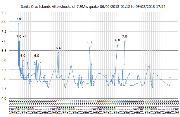
update of data (GFZ) for Santa Cruz Islands aftershocks graph at 88:42:08hrs after mainshock
15 quakes in 12 hours, largest 5.7, looks like its settling down

based on GFZ's estimate that it was a 7.9Mw and not a 8.0Mw
Total Energy Released= 12,802,623.79 TTNT
mainshock ER= 10,675,994.08 TTNT
aftershocks ER= 2,126,629.71 TTNT
15 quakes in 12 hours, largest 5.7, looks like its settling down

based on GFZ's estimate that it was a 7.9Mw and not a 8.0Mw
Total Energy Released= 12,802,623.79 TTNT
mainshock ER= 10,675,994.08 TTNT
aftershocks ER= 2,126,629.71 TTNT
edit on 9-2-2013 by muzzy because: (no reason given)
seems to be quite a correlation between recent volcanic/eq activity.

or is this normal?
images from - realtimetools.de...

or is this normal?
images from - realtimetools.de...
damn it!
geofon.gfz-potsdam.de...
geofon.gfz-potsdam.de...
F-E Region: Santa Cruz Islands
Time: 2013-02-09 21:02:25.8 UTC
Magnitude: 6.6 (Mw)
Epicenter: 165.72°E 10.96°S
Depth: 34 km
Status: M - manually revised
geofon.gfz-potsdam.de...
edit on 9-2-2013 by muzzy because: (no reason given)
F-E Region: Santa Cruz Islands
Time: 2013-02-09 22:14:31.3 UTC
Magnitude: 6.0 (mb?)
Epicenter: 165.87°E 10.90°S
Depth: 10 km
Status: A - automatic
geofon.gfz-potsdam.de...
edit on 9-2-2013 by muzzy because: add another one
reply to post by muzzy
Muzzy, please explain 'Damn it'. i am wondering why the latest EQ 6.6 Santa Cruz is not registering on the LISS - Live Internet Seismogram?? earthquake.usgs.gov... The 6.9 Columbia one did?
well maybe it is registering now, but a delay of an hour and a half and doesn't seem to come close to the waves generated by the 6.9? can you she some light on this?
one more thing i have both the old usgs and the new up and i see that the old one registers eq's much faster, showing 2 more for the Santa Cruz area pretty good for an obsolete map, i would say.
MAP 5.1 2013/02/09 22:49:06 -10.980 165.750 40.8 SANTA CRUZ ISLANDS
MAP 5.3 2013/02/09 22:14:35 -10.990 165.782 37.0 SANTA CRUZ ISLANDS
Muzzy, please explain 'Damn it'. i am wondering why the latest EQ 6.6 Santa Cruz is not registering on the LISS - Live Internet Seismogram?? earthquake.usgs.gov... The 6.9 Columbia one did?
well maybe it is registering now, but a delay of an hour and a half and doesn't seem to come close to the waves generated by the 6.9? can you she some light on this?
edit on 9-2-2013 by whatnext21 because: (no reason given)
one more thing i have both the old usgs and the new up and i see that the old one registers eq's much faster, showing 2 more for the Santa Cruz area pretty good for an obsolete map, i would say.
MAP 5.1 2013/02/09 22:49:06 -10.980 165.750 40.8 SANTA CRUZ ISLANDS
MAP 5.3 2013/02/09 22:14:35 -10.990 165.782 37.0 SANTA CRUZ ISLANDS
edit on 9-2-2013 by whatnext21 because: (no reason
given)
reply to post by whatnext21
Add two more to that tally:
5.2 14km SSE of Lata, Solomon Islands 2013-02-09 23:13:43 10.843°S 165.864°E 44.0
5.4 22km SSE of Lata, Solomon Islands 2013-02-09 23:09:44 10.916°S 165.883°E 28.7
All four in pretty rapid succession following that 6.6.
(the 5.2 literally happened as I was typing this)
Add two more to that tally:
5.2 14km SSE of Lata, Solomon Islands 2013-02-09 23:13:43 10.843°S 165.864°E 44.0
5.4 22km SSE of Lata, Solomon Islands 2013-02-09 23:09:44 10.916°S 165.883°E 28.7
All four in pretty rapid succession following that 6.6.
(the 5.2 literally happened as I was typing this)
reply to post by whatnext21
2 reasons,
1. I had just done a new graph at 18:18 UTC and had closed the file.
2. I wouldn't wish a 6.6 earthquake on anyone, let alone those poor islanders who's lives are now in ruins.
LISS updates every 30 minutes, its not automatically refreshing, so you have to do it yourself if you already had the page opened.
I had the 6.6 on SNZO at 22:18
I also lost the seconds off the end of my "when" column in the meantime, doesn't make much difference to the graphs I have been doing, but not too good on the map popups, but we are looking at 5+ pages of data from GFZ now, I can't be bothered doing it all again.
hh:mm it is from now on.
reply to post by muzzy
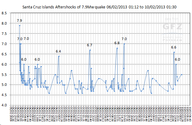
Man, muzzy, that graph of yours is starting to look like pulse readings on an EKG.
Man, muzzy, that graph of yours is starting to look like pulse readings on an EKG.
edit on 9-2-2013 by deometer because: (no reason
given)
reply to post by deometer
yes there is definitely a pulse.
Its is said if all the earthquakes that we get suddenly stop then that is the time to get REAL worried, earthquakes create life and energy (and kill people) ie no earthquakes=the planet is dead.
yes there is definitely a pulse.
Its is said if all the earthquakes that we get suddenly stop then that is the time to get REAL worried, earthquakes create life and energy (and kill people) ie no earthquakes=the planet is dead.
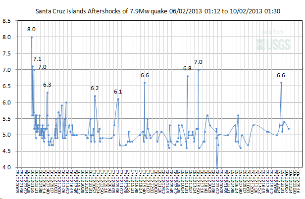
just for the heck of it GFZ (143a/s) versus USGS (172a/s)


I've switched to GIF's, uses up less storage space than PNG's (1/2)


I've switched to GIF's, uses up less storage space than PNG's (1/2)
Does anyone know if there is a thread specifically about the recent eq activity in the Solomon islands... as to not clutter this thread??
Originally posted by PatriotsPride
reply to post by steve95988
here ya go
www.abovetopsecret.com...
Thank you!
2nd
reply to post by steve95988
Why? don't you like this thread?, need something more ...................American.........................
geez I just gave ya a USGS graph
justkiddingoffyougo
Why? don't you like this thread?, need something more ...................American.........................
geez I just gave ya a USGS graph
justkiddingoffyougo
reply to post by muzzy
Hey hey now...
I participate here and you don't even make a showing... !
I'm sicking the Lake Taupo monster on you!
Hey hey now...
I participate here and you don't even make a showing... !
I'm sicking the Lake Taupo monster on you!
Originally posted by muzzy
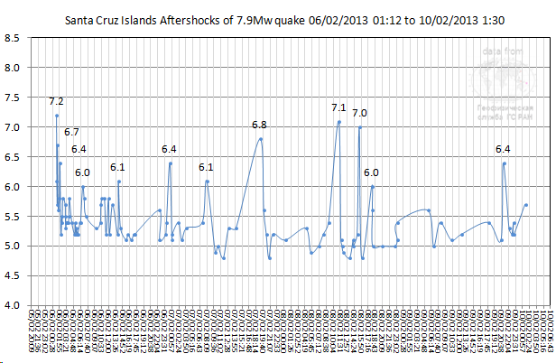
just for the heck of it GFZ (143a/s) versus USGS (172a/s)
I've switched to GIF's, uses up less storage space than PNG's (1/2)
Just like when you get any work done, you should always get 3 quotes.
Geophysical Service of the Russian Academy of Sciences (GS RAS) (106a/s)

edit: ha i didn't change the titles on those two other graphs, should be 8.0Mww for the USGS one and 7.2Ms for the GSRAS one, but you guys get the drift.
What the heck is Mww anyway? MomentWhat?What?
[color=A0CFEC]each bold text/title below is the link to the page
USGS Centroid Moment Solution
SANTA CRUZ ISLANDS
13/02/06 01:12:26.96
Epicenter: -10.736 165.144
MW 7.9
USGS WPhase Moment Solution
SANTA CRUZ ISLANDS
13/ 2/ 6 1:12:23.00
Epicenter: -10.751 165.088
MW 8.0
Earthquake Details
Magnitude 8.0
Date-Time Wednesday, February 06, 2013 at 01:12:27 UTC
Parameters NST=347, Nph=351, Dmin=586.7 km, Rmss=1.28 sec, Gp= 18°,
M-type=(unknown type), Version=B
so when was it and how big
edit on 10-2-2013 by muzzy because: only the GFZers and Ruskies seem to be confident in their estimate, a
definite Mw and a definite Ms
reply to post by TrueAmerican
just having a laugh, I didn't even know you started a topic on it, I usually go straight to this (last page) without even looking at the ATS or Fragile Earth Menu.
Some good posts on there about the "gas" and "Villagers on nearby islands have been reporting increased activity at Tinakula volcano"
I know its not a competition, but one wonders why/how you got 41 stars
and I only got 2 stars
for spotting what was happening quite early on 31-1-2013 @ 05:32 PM
It was just luck I had the afternoon off that day, otherwise I'd have never seen it till later.
and why is that steve95988 asking if there is another thread on Santa Cruz?, when he/she was the 2nd person to post on that thread? at 2-2-2013 @ 12:01 PM page one of what is currently at 10 pages long.
I see a Conspiracy
edit on 9-2-2013 by muzzy because: I don't really care though
Really? So it's only a coincidence that the plate moved on the opposites side as Puterman noted also? Okay not exactly evidence but it only makes
sense that if one plate moves another will have to move and make way somehow.
2013-02-09 14:16:09 UTC
2013-02-09 09:16:09 UTC-05:00 at epicenter
2013-02-09 06:16:09 UTC-08:00 system time
Location
1.167°N 77.384°W depth=153.8km (95.6mi)
Nearby Cities
5km (3mi) NNE of Yacuanquer, Colombia
12km (7mi) WSW of Pasto, Colombia
17km (11mi) SE of Sandona, Colombia
27km (17mi) ENE of Tuquerres, Colombia
199km (124mi) NE of Quito, Ecuador
Originally posted by PuterMan
reply to post by slidingdoor
Yup it is the nearest.
www.abovetopsecret.com...
Twisting and turning. Now Colombia - opposite Santa Cruz. Round and round goes the Pacific Plate.
Geofon have 6.9 by the way: geofon.gfz-potsdam.de...
Columbia and then California - slip the San Andreas a little and then Cascadia? Well I hope not, but the way things are going 21 December 2012 looks like it is happening slowly - it was the start of the end of the world after all.
edit on 9/2/2013 by PuterMan because: (no reason given)
Originally posted by muzzy
reply to post by favouriteslave
Is there any evidence that this can happen?
No
Originally posted by favouriteslave
Originally posted by MamaJ
Originally posted by Olivine
reply to post by MariaLida
MariaLida you were correct. Nice work.
I second that! Nice work!
ETA: Is there a bigger one lurking? Or is this it? Predict away!
edit on 5-2-2013 by MamaJ because: (no reason given)
If not in the same place then across the Pacific either S. America or Central America.
edit on 10-2-2013 by favouriteslave because:
(no reason given)
new topics
-
Don't cry do Cryo instead
General Chit Chat: 6 minutes ago -
Tariffs all around, Except for ...
Predictions & Prophecies: 2 hours ago -
Gen Flynn's Sister and her cohort blow the whistle on DHS/CBP involvement in child trafficking.
Whistle Blowers and Leaked Documents: 6 hours ago -
Anybody else using Pomodoro time management technique?
General Chit Chat: 9 hours ago -
Bucks County commissioners vote to count illegal ballots in Pennsylvania recount
2024 Elections: 11 hours ago
top topics
-
Trump sues media outlets -- 10 Billion Dollar lawsuit
US Political Madness: 12 hours ago, 24 flags -
Bucks County commissioners vote to count illegal ballots in Pennsylvania recount
2024 Elections: 11 hours ago, 21 flags -
How long till it starts
US Political Madness: 14 hours ago, 17 flags -
USSS Agent Fired for Having Sex In Michelle Obama's Bathroom
Politicians & People: 16 hours ago, 10 flags -
Fired fema employee speaks.
US Political Madness: 13 hours ago, 10 flags -
Gen Flynn's Sister and her cohort blow the whistle on DHS/CBP involvement in child trafficking.
Whistle Blowers and Leaked Documents: 6 hours ago, 8 flags -
Anybody else using Pomodoro time management technique?
General Chit Chat: 9 hours ago, 3 flags -
Tariffs all around, Except for ...
Predictions & Prophecies: 2 hours ago, 1 flags -
Don't cry do Cryo instead
General Chit Chat: 6 minutes ago, 0 flags
active topics
-
Don't cry do Cryo instead
General Chit Chat • 0 • : 727Sky -
Tariffs all around, Except for ...
Predictions & Prophecies • 7 • : FullHeathen -
President-Elect DONALD TRUMP's 2nd-Term Administration Takes Shape.
Political Ideology • 205 • : WeMustCare -
On Nov. 5th 2024 - AMERICANS Prevented the Complete Destruction of America from Within.
2024 Elections • 155 • : WeMustCare -
Mike Tyson returns 11-15-24
World Sports • 53 • : Blueracer -
The Trump effect 6 days after 2024 election
2024 Elections • 143 • : cherokeetroy -
Bucks County commissioners vote to count illegal ballots in Pennsylvania recount
2024 Elections • 21 • : Irishhaf -
60s-70s Psychedelia
Music • 54 • : gort69 -
The art of being offended
Social Issues and Civil Unrest • 49 • : gort69 -
Gen Flynn's Sister and her cohort blow the whistle on DHS/CBP involvement in child trafficking.
Whistle Blowers and Leaked Documents • 6 • : gort69
