It looks like you're using an Ad Blocker.
Please white-list or disable AboveTopSecret.com in your ad-blocking tool.
Thank you.
Some features of ATS will be disabled while you continue to use an ad-blocker.
share:
Originally posted by muzzy
reply to post by deometer
yes there is definitely a pulse.
Its is said if all the earthquakes that we get suddenly stop then that is the time to get REAL worried, earthquakes create life and energy (and kill people) ie no earthquakes=the planet is dead.
No no no no, no need to get worried, we can just create them........
Gas-Rich Groningen Province in Netherlands Hit by New Earthquake
The Dutch province of Groningen, which sits on the Slochteren gas deposit, was hit by another earthquake as pressure grows on Royal Dutch Shell Plc and Exxon Mobil Corp. to cut output amid forecasts of heavier temblors.
A quake measuring 2.7 on the Richter scale struck the area at about 6:30 a.m. local time, following two quakes on Feb. 7 and yesterday, the Royal Netherlands Meteorological Institute, or KNMI, said in a statement on its website.
Now here is a complete admission of guilt
...that operates the Slochteren field, will compensate for all damage caused by the earthquakes, it said yesterday
BTW Muzzy you only got 2 (3 now) stars because it was not a new thread and you don't have a gold edge to your posts
Ach: Forgot the linkypoo
edit on 10/2/2013 by PuterMan because: (no reason given)
reply to post by crappiekat
Funny you should pick that one out. Earlier in the day GFZ Potsdam has that as a Mag 6 M against EMSC and USGS 5.3mb
According to Muzzy's formula this translates to 5.66Mw, or rounded 5.7Mw (or M) an lo and behold GFZ now have it at that.
I don't suppose that was why you thought it was interesting. Are you thinking transfer to Tonga from Santa Cruz?
PS read your u2u
Funny you should pick that one out. Earlier in the day GFZ Potsdam has that as a Mag 6 M against EMSC and USGS 5.3mb
According to Muzzy's formula this translates to 5.66Mw, or rounded 5.7Mw (or M) an lo and behold GFZ now have it at that.
Prov,Date/Time UTC,Latitude,Longitude,Magnitude,Depth(Km),Location
gfzp,2013-02-10 09:37:11, -18.640, -174.690, 5.7M, 111.0, Tonga Isls.
usgs,2013-02-10 09:37:13, -18.579, -174.659, 5.3mb, 132.0, Tonga
emsc,2013-02-10 09:37:13, -18.563, -174.752, 5.5mb, 128.0, Tonga
I don't suppose that was why you thought it was interesting. Are you thinking transfer to Tonga from Santa Cruz?
PS read your u2u
Another Mag 6.0 in the Santa Cruz Islands
source
Just when I thought it was slowing down...
ETA: USGS says:
Looking at the depth and location, this one may actually be another thrust mechanism. Have to wait for the verdict.
Magnitude M 6.0
Region SANTA CRUZ ISLANDS
Date time 2013-02-10 18:39:34.0 UTC
Location 11.02 S ; 165.44 E
Depth 15 km
Distances 2242 km NE Brisbane (pop 1,843,392 ; local time 04:39:34.6 2013-02-11)
1605 km NW Suva (pop 199,455 ; local time 06:39:34.6 2013-02-11)
532 km NW Luganville (pop 13,397 ; local time 05:39:34.6 2013-02-11)
55 km SW Lata (pop 538 ; local time 05:39:34.6 2013-02-11)
source
Just when I thought it was slowing down...
ETA: USGS says:
M6.3 - 51km SW of Lata, Solomon Islands
2013-02-10 18:39:35 UTC
Looking at the depth and location, this one may actually be another thrust mechanism. Have to wait for the verdict.
edit on 2/10/2013 by Olivine because: add info
edit on 2/10/2013 by Olivine because: (no reason given)
edit on
2/10/2013 by Olivine because: (no reason given)
reply to post by crappiekat
why is that?
depth?
1st of the year for that spot?
could be more of the Pacific Plate dropping into the mantle at that depth
plenty of previous though
historical seismicity 1990- from USGS
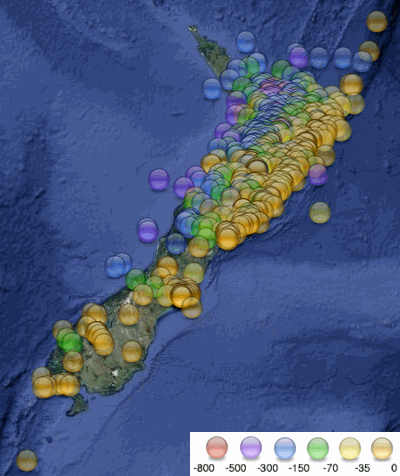
NZ continues to have quite a lot of DEEP quakes.
I did this map based on depth, its something I should do more often, but the pattern is always the same, its just the amount of deep quakes the last 10 days that caught my eye, or maybe I wasn't looking for depth before.
Here is one of the last 10 days, I'll do another for Jan later to see the difference (if any)
I used the same colours as USGS for the depths, so as not to confuse readers who go there for their info
[color=lime](click image for interactive map, opens in new tab/window)
edit on 10-2-2013 by muzzy because: don't like that key at the bottom, did it in a rush, will tidy that up
reply to post by Olivine
Haven't got the time to update the graph I have been doing right now, but seems a 6+ each day on a regular basis around the 15:00 to 19:00 UTC hour mark
edit:
yeah there is a pattern there too.
The early westerly ones were in the a.m
and the later easterly ones in the p.m.
list below is off USGS and unaltered re. sequence
strange
Haven't got the time to update the graph I have been doing right now, but seems a 6+ each day on a regular basis around the 15:00 to 19:00 UTC hour mark
edit:
yeah there is a pattern there too.
The early westerly ones were in the a.m
and the later easterly ones in the p.m.
list below is off USGS and unaltered re. sequence
6.3 10/02/2013 18:39 10.978°S 165.444°E 35
6.6 9/02/2013 21:02 10.964°S 165.792°E 15.7
7.0 8/02/2013 15:26 10.910°S 165.964°E 26.9
6.8 8/02/2013 11:12 10.904°S 165.895°E 18
6.6 7/02/2013 18:59 11.001°S 165.658°E 10
6.3 6/02/2013 6:35 10.784°S 164.512°E 10.1
7.0 6/02/2013 1:54 10.479°S 165.772°E 9.8
7.1 6/02/2013 1:23 11.254°S 164.932°E 10.1
8.0 6/02/2013 1:12 10.738°S 165.138°E 28.7
strange
edit on 10-2-2013 by muzzy because: (no reason given)
reply to post by muzzy
It is really strange. It's as if that entire area is spider-webbing with cracks--one quake sends stress to an adjacent area, a few hours go by, and then the next area pops, and on and on it goes.
Also, Chile looks to be getting back into action. Mag 5.7
It is really strange. It's as if that entire area is spider-webbing with cracks--one quake sends stress to an adjacent area, a few hours go by, and then the next area pops, and on and on it goes.
Also, Chile looks to be getting back into action. Mag 5.7
Originally posted by muzzy
reply to post by Olivine
Haven't got the time to update the graph I have been doing right now, but seems a 6+ each day on a regular basis around the 15:00 to 19:00 UTC hour mark
edit:
yeah there is a pattern there too.
The early westerly ones were in the a.m
and the later easterly ones in the p.m.
list below is off USGS and unaltered re. sequence
6.3 10/02/2013 18:39 10.978°S 165.444°E 35
6.6 9/02/2013 21:02 10.964°S 165.792°E 15.7
7.0 8/02/2013 15:26 10.910°S 165.964°E 26.9
6.8 8/02/2013 11:12 10.904°S 165.895°E 18
6.6 7/02/2013 18:59 11.001°S 165.658°E 10
6.3 6/02/2013 6:35 10.784°S 164.512°E 10.1
7.0 6/02/2013 1:54 10.479°S 165.772°E 9.8
7.1 6/02/2013 1:23 11.254°S 164.932°E 10.1
8.0 6/02/2013 1:12 10.738°S 165.138°E 28.7
strange
edit on 10-2-2013 by muzzy because: (no reason given)
You have not figured it out yet......Their HAARPING the crap out that area
edit on 10-2-2013 by radpetey because: (no reason
given)
reply to post by Olivine
Heavily optimised animation of the Santa Cruz quakes, by day, from EMSC Mag 4+ (334 KB if you want to save it)
Dates 03 Feb to 19:30 on 10 Feb
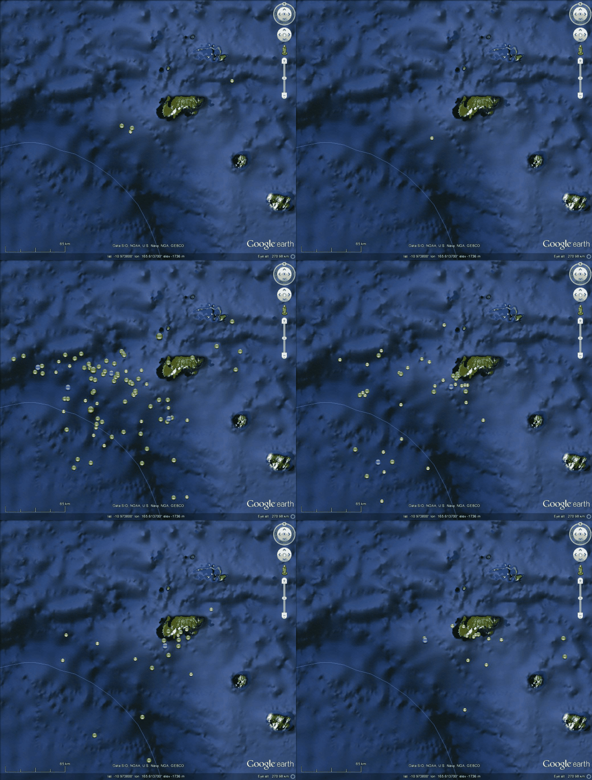
Full colour version of the file 2+MB download 7z file (zip) 8+ Mb unzipped.
And a sequence of just the Mag 6+. Look at the curve it forms on the last image.
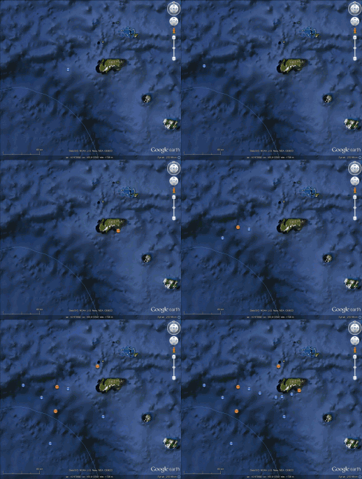
And one of the small one just above but over 2x as big. Download 2.5+ MB
Heavily optimised animation of the Santa Cruz quakes, by day, from EMSC Mag 4+ (334 KB if you want to save it)
Dates 03 Feb to 19:30 on 10 Feb

Full colour version of the file 2+MB download 7z file (zip) 8+ Mb unzipped.
And a sequence of just the Mag 6+. Look at the curve it forms on the last image.

And one of the small one just above but over 2x as big. Download 2.5+ MB
edit on 10/2/2013 by PuterMan because: (no reason given)
I think the whole region is unstable, maybe of the volcano, maybe not... I am not sure
This latest 5.0 is quite a distance from the last 6.3 but at the same depth.
Is it an ominous sign given this is at the prime subduction depth? Is there any way to know for sure??
Is it an ominous sign given this is at the prime subduction depth? Is there any way to know for sure??
reply to post by radpetey
Maybe an historical quakes overlay will help your determinations. This is Mag 6 and 7 quakes (No mag 8 until now) from 1898 to Feb 2012 (when I last made the file) - plus the last 7 days.

Click for a larger image.
I obliterated it for you.

Click for a larger image.
Maybe an historical quakes overlay will help your determinations. This is Mag 6 and 7 quakes (No mag 8 until now) from 1898 to Feb 2012 (when I last made the file) - plus the last 7 days.

Click for a larger image.
I obliterated it for you.

Click for a larger image.
edit on 10/2/2013 by PuterMan because: (no reason given)
It really is TEOTWAWKI !!!
Even Santa isn't safe anymore!!!
MAP 1.0 2013/02/10 21:54:42 64.434 -147.992 5.2 47 km ( 29 mi) SW of North Pole, AK
Stay SAFE Santa!!!!
SOURCE: USGS
WOQ
Even Santa isn't safe anymore!!!
MAP 1.0 2013/02/10 21:54:42 64.434 -147.992 5.2 47 km ( 29 mi) SW of North Pole, AK
Stay SAFE Santa!!!!
SOURCE: USGS
WOQ
Well, there is certainly a while lot of shaking going on, to say the least. I grabbed this from the USGS site a short time go...
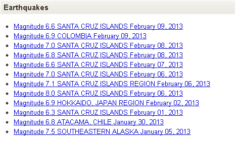
and of course these things DO happen. A given average every year, in fact. There have been much stronger than these recent ones in living memory, too.
What kinda bothers me though is the pattern it's almost seeming to follow.....
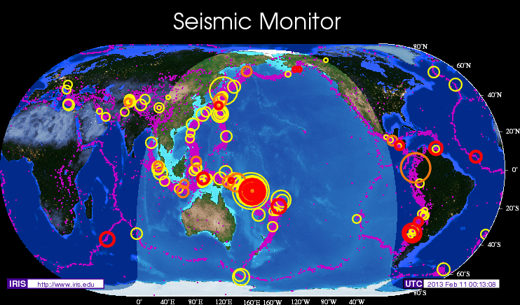
Indeed, I see the ring of fire and down around the Southern Pacific plate boundary waking up and having some notable quakes. I even see it around the top and across Alaska. There sure is a quiet area though, isn't there? Is it a good or a bad thing that the boundary sections around the rest are releasing stress in great amounts but the West Coast of North America is staying static for tension released? Does that mean it's building in the calm spot? Hmm...

and of course these things DO happen. A given average every year, in fact. There have been much stronger than these recent ones in living memory, too.

What kinda bothers me though is the pattern it's almost seeming to follow.....

Indeed, I see the ring of fire and down around the Southern Pacific plate boundary waking up and having some notable quakes. I even see it around the top and across Alaska. There sure is a quiet area though, isn't there? Is it a good or a bad thing that the boundary sections around the rest are releasing stress in great amounts but the West Coast of North America is staying static for tension released? Does that mean it's building in the calm spot? Hmm...
sorry to be a pain but can someone give me a rough estimate of just how many quakes of over say about 5.0 that have occured around the santa cruz area
in the last few weeks ????
reply to post by Wrabbit2000
No actually they do not happen, at least not t Santa Cruz. As I and others have pointed out the current spate of Mag 6+ earthquakes in the Santa Cruz area is unprecedented in seismological history. That is not to say that it has not happened before, and there have been similar but less intense episodes, but if they did happen we do not know about them.
As far as Santa Cruz is concerned they don't and haven't come any stronger. The max at SC was a mag 7.9 and is now a mag 8.0 (but I think this will be 7.9 eventually).
There may have been larger ones elsewhere, but not in the Santa Cruz Islands.
That is about the size of it
PS This may interest the stats people.
and of course these things DO happen. A given average every year, in fact. There have been much stronger than these recent ones in living memory, too.
No actually they do not happen, at least not t Santa Cruz. As I and others have pointed out the current spate of Mag 6+ earthquakes in the Santa Cruz area is unprecedented in seismological history. That is not to say that it has not happened before, and there have been similar but less intense episodes, but if they did happen we do not know about them.
As far as Santa Cruz is concerned they don't and haven't come any stronger. The max at SC was a mag 7.9 and is now a mag 8.0 (but I think this will be 7.9 eventually).
There may have been larger ones elsewhere, but not in the Santa Cruz Islands.
Does that mean it's building in the calm spot? Hmm...
That is about the size of it
edit on 10/2/2013 by PuterMan because: (no reason given)
PS This may interest the stats people.
edit on 10/2/2013 by PuterMan because: (no reason given)
Originally posted by bellagirl
sorry to be a pain but can someone give me a rough estimate of just how many quakes of over say about 5.0 that have occured around the santa cruz area in the last few weeks ????
Last 31 days Mag 5+ (BUT the first date is 31 Jan so actually only 11 days)
USGS = 146 (M5 - 127, M6 - 15, M7 - 3, M8 - 1)
EMSC = 144 (M5 - 125, M6 - 15, M7 - 4)
GFZ Potsdam = 127 (M5 - 108, M6 - 15, M7 - 4)
edit on 10/2/2013 by PuterMan because: (no reason given)
Originally posted by bellagirl
sorry to be a pain but can someone give me a rough estimate of just how many quakes of over say about 5.0 that have occured around the santa cruz area in the last few weeks ????
Using USGS standard mapping options which show only 6.0 and up for the last 30 days; I get:
earthquake.usgs.gov...
16 earthquakesSignificant events in the past 30 days
12 meet criterialocated in map area
12 displayedbased on sort order
The same query set to "all" instead of "significant" nets 238.
I realize you asked for 5+ and the last "few" weeks - and - the answers I gave are divided at the 6+ marker and 30 days ... but, hopefully that gives some idea.
Ooops, didn't know Puter Man was helping ya. Ignore my figures.
My note to self - see also: www.abovetopsecret.com... that started only 1 February 2013.
edit on 10/2/2013 by
Trexter Ziam because: (no reason given)
reply to post by PuterMan
Okay, let's keep some perspective here and avoid terms like never or unprecedented. Those are terms for fear mongering reporters, IMO. Not serious researchers.
In terms of data, I did go to do a little checking.....This is the search box I used:
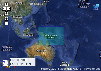
(Source)
And simply search Magnitude 6+ open to the date range they record. Since 2004, there have been 147 Earthquakes of 6 or above. In the same area, there have been 17 at magnitude 7 and above. This includes an 8.1 in April of 2007.
I'm sure the epicenters aren't overlapping or perhaps even "close" for political boundaries on a map, but within that square? It's happened before and nothing much unprecedented here.....although interesting when taken with other activity around the Pacific Rim nations, indeed. I'm sure watching for what else develops anyway.
Okay, let's keep some perspective here and avoid terms like never or unprecedented. Those are terms for fear mongering reporters, IMO. Not serious researchers.
In terms of data, I did go to do a little checking.....This is the search box I used:

(Source)
And simply search Magnitude 6+ open to the date range they record. Since 2004, there have been 147 Earthquakes of 6 or above. In the same area, there have been 17 at magnitude 7 and above. This includes an 8.1 in April of 2007.
I'm sure the epicenters aren't overlapping or perhaps even "close" for political boundaries on a map, but within that square? It's happened before and nothing much unprecedented here.....although interesting when taken with other activity around the Pacific Rim nations, indeed. I'm sure watching for what else develops anyway.
edit on 10-2-2013 by Wrabbit2000 because: Fixed Link
new topics
-
Don't cry do Cryo instead
General Chit Chat: 23 minutes ago -
Tariffs all around, Except for ...
Predictions & Prophecies: 2 hours ago -
Gen Flynn's Sister and her cohort blow the whistle on DHS/CBP involvement in child trafficking.
Whistle Blowers and Leaked Documents: 7 hours ago -
Anybody else using Pomodoro time management technique?
General Chit Chat: 9 hours ago
top topics
-
Trump sues media outlets -- 10 Billion Dollar lawsuit
US Political Madness: 13 hours ago, 24 flags -
Bucks County commissioners vote to count illegal ballots in Pennsylvania recount
2024 Elections: 12 hours ago, 21 flags -
How long till it starts
US Political Madness: 14 hours ago, 17 flags -
USSS Agent Fired for Having Sex In Michelle Obama's Bathroom
Politicians & People: 16 hours ago, 10 flags -
Fired fema employee speaks.
US Political Madness: 13 hours ago, 10 flags -
Gen Flynn's Sister and her cohort blow the whistle on DHS/CBP involvement in child trafficking.
Whistle Blowers and Leaked Documents: 7 hours ago, 8 flags -
Anybody else using Pomodoro time management technique?
General Chit Chat: 9 hours ago, 3 flags -
Tariffs all around, Except for ...
Predictions & Prophecies: 2 hours ago, 1 flags -
Don't cry do Cryo instead
General Chit Chat: 23 minutes ago, 0 flags
active topics
-
Tariffs all around, Except for ...
Predictions & Prophecies • 8 • : sonofred -
Don't cry do Cryo instead
General Chit Chat • 0 • : 727Sky -
President-Elect DONALD TRUMP's 2nd-Term Administration Takes Shape.
Political Ideology • 205 • : WeMustCare -
On Nov. 5th 2024 - AMERICANS Prevented the Complete Destruction of America from Within.
2024 Elections • 155 • : WeMustCare -
Mike Tyson returns 11-15-24
World Sports • 53 • : Blueracer -
The Trump effect 6 days after 2024 election
2024 Elections • 143 • : cherokeetroy -
Bucks County commissioners vote to count illegal ballots in Pennsylvania recount
2024 Elections • 21 • : Irishhaf -
60s-70s Psychedelia
Music • 54 • : gort69 -
The art of being offended
Social Issues and Civil Unrest • 49 • : gort69 -
Gen Flynn's Sister and her cohort blow the whistle on DHS/CBP involvement in child trafficking.
Whistle Blowers and Leaked Documents • 6 • : gort69

