It looks like you're using an Ad Blocker.
Please white-list or disable AboveTopSecret.com in your ad-blocking tool.
Thank you.
Some features of ATS will be disabled while you continue to use an ad-blocker.
share:
Originally posted by muzzy
trouble is we don't know they are foreshocks until the main shock hits
I just wanted to say: how do we know that this are all aftershocks? What if this are all just foreshocks to a even bigger one like M8.5... you can never say until the activity stopped.
But there is better news for Japan........
Japan Earthquake unleashed surprising torrent of energy
Well, allegedly anyway!
Japan Earthquake unleashed surprising torrent of energy
Well, allegedly anyway!
Originally posted by phoenixlights321
Originally posted by deometer
Looks like they converted one of the old ones (6.8, I believe) up to 7.1:
M7.1 - 114km WSW of Lata, Solomon Islands
2013-02-06 01:23:19 UTC
earthquake.usgs.gov...
So many aftershocks! Pretty big ones too! Are there usually this many?
There are always aftershocks, but I don't remember any quake having multiple 7+'s in such a short time afterwards, definitely not the norm, but good luck getting a straight answer out of anyone as to why it is happening. They will say it is not quite normal but not outside of the boundaries of what could be predicted - with no geological explanation that is worthy.
This area where the quakes are happening in the Santa Cruz Islands appears to be kind of a "hinge" point for the Pacific Plate, and with so much adjustment there it will be interesting to see if we get any corresponding movement from Alaska down to Chile over the next couple of days or weeks. I would be surprised if we DIDN'T get a major quake somewhere on our side of the Pacific over the next few weeks - a major quake.
edit on 8-2-2013 by PlanetXisHERE because: addition
I'm wondering if Santa Cruz will be like the New Madrid event in 1811-1812? New Madrid had four large eq's over a three month period from December
to February.
We are used to large eq, big aftershock, and lots of smaller ones.
Just food for thought.
Peace
We are used to large eq, big aftershock, and lots of smaller ones.
Just food for thought.
Peace
reply to post by PlanetXisHERE
I just don't know to be honest. That report from Japan looks to be a bit of a game changer in terms of our understanding (i believe the fault around the Solomon Islands is similar to the one in Japan).
It certainly appears to be building towards something bigger but longer term it would now appear that could result in a major decrease in stress levels.
Obviously though, that isn't much consolation if you live on an island about a metre above sea level.
Originally posted by muzzy
[color=lime](click image for interactive map, opens in new tab/window)
looks like a bit of a pattern with those 6's eh.
And they are getting bigger
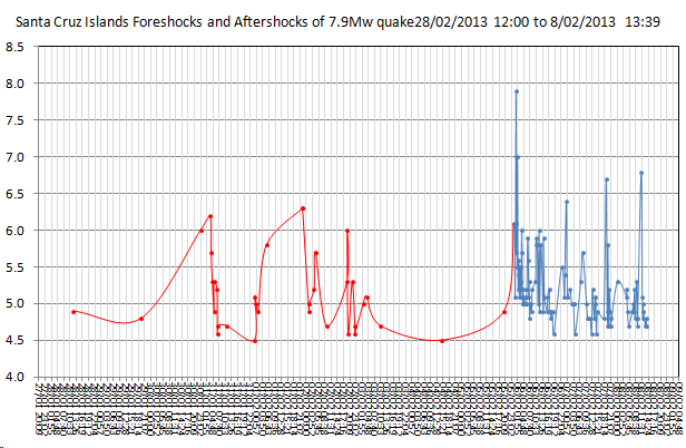
Forgive me if I am stating the obvious here, but that pattern emerging, it looks a lot like the foreshocks pattern in the graph directly above it, no?
reply to post by aLLeKs
Well you sort of can say that these are aftershocks because (making many assumptions) there is insufficient energy left in the region for more that a Mag 7.5 at this time.
Without out detailed data from the year dot I have assumed that the Mag 7.6 (weekly equivalent) in 1900 week 30 left the region at zero energy. The reason that I believe this to be the case is because it was then a further year+ before the region managed a 6.9 weekly equivalent and a further 2 years before there was another 6.8 weekly equivalent.
In fact right up to around 1965 or a bit before (1960 Chile trigger?) the system seems to have been building energy and not releasing a great deal.
From ~1965 onwards there have been several multiple Mag 6 releases in a week, and the system has a low energy value after the Mag 8 and Mag 7 quakes.
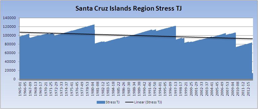
Click for larger image
THIS IS ONLY THEORETICAL AND SHOULD NOT BE TAKEN AS AN EXACT REPRESENTATION OF THE STRESS STATE.
The real problem is knowing where the system is a zero stress. Since 1900 is the first figure I have I have assumed that to be zero as no weeks fall into a negative stress value. This does NOT mean that the system was at zero in 1900 but it is a reasonable assumption. The stress before that quakes works out at 15,788 TJ. For there to be a Mag 8 left in the system now that would need to have been 70,000 TJ. For there to be a Mag 9 left in the system that initial value would need to be 2,000,000 TJ.
I would say that there would have been many more earlier quakes (1900-1965) if either of those scenarios were true.
This is the full chart from a 1900 zero stress point. Note that the 2013 end does show a drop but it is difficult to see as it has only just happened.
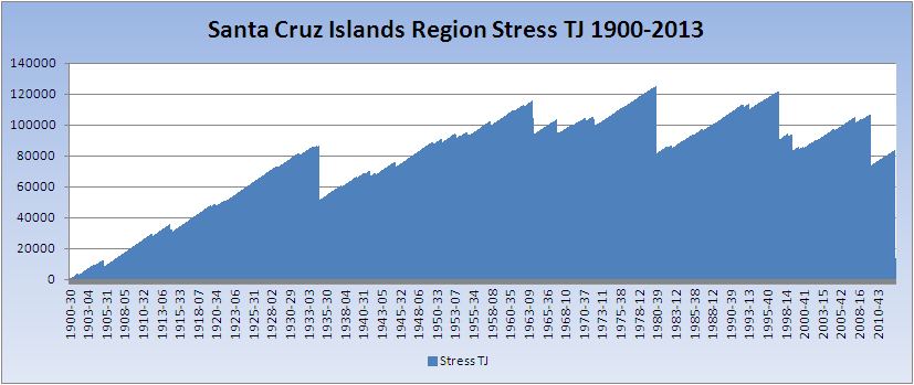
Click for a larger image
And finally one more with the potential magnitude graphed onto it

Click for a much larger image
Well you sort of can say that these are aftershocks because (making many assumptions) there is insufficient energy left in the region for more that a Mag 7.5 at this time.
Without out detailed data from the year dot I have assumed that the Mag 7.6 (weekly equivalent) in 1900 week 30 left the region at zero energy. The reason that I believe this to be the case is because it was then a further year+ before the region managed a 6.9 weekly equivalent and a further 2 years before there was another 6.8 weekly equivalent.
In fact right up to around 1965 or a bit before (1960 Chile trigger?) the system seems to have been building energy and not releasing a great deal.
From ~1965 onwards there have been several multiple Mag 6 releases in a week, and the system has a low energy value after the Mag 8 and Mag 7 quakes.

Click for larger image
THIS IS ONLY THEORETICAL AND SHOULD NOT BE TAKEN AS AN EXACT REPRESENTATION OF THE STRESS STATE.
The real problem is knowing where the system is a zero stress. Since 1900 is the first figure I have I have assumed that to be zero as no weeks fall into a negative stress value. This does NOT mean that the system was at zero in 1900 but it is a reasonable assumption. The stress before that quakes works out at 15,788 TJ. For there to be a Mag 8 left in the system now that would need to have been 70,000 TJ. For there to be a Mag 9 left in the system that initial value would need to be 2,000,000 TJ.
I would say that there would have been many more earlier quakes (1900-1965) if either of those scenarios were true.
This is the full chart from a 1900 zero stress point. Note that the 2013 end does show a drop but it is difficult to see as it has only just happened.

Click for a larger image
And finally one more with the potential magnitude graphed onto it

Click for a much larger image
edit on 8/2/2013 by PuterMan because: (no reason given)
reply to post by PuterMan
Puterman, have you had a chance to read the article Flavian posted about an hour ago?
An interesting excerpt:
I didn't know this. I'm wondering, up to what magnitude do quakes only release 10% of the built up stress. What do they consider a "conventional eq"?
Would this change the way you compute your sawtooth graphs?
Puterman, have you had a chance to read the article Flavian posted about an hour ago?
An interesting excerpt:
Link to source article
... studies have shown that in conventional earthquakes and smaller faults, only 10 percent or some other small fraction of the stress is released when these blocks of rock slip past each other."
I didn't know this. I'm wondering, up to what magnitude do quakes only release 10% of the built up stress. What do they consider a "conventional eq"?
Would this change the way you compute your sawtooth graphs?
reply to post by Olivine
Hi Olivine. Yes I have read it and I am not surprised that the really big quakes release nearly all the stress. The question really is at what point do they not release all the stress. We know from the coulomb stress diagrams that stress is transferred to other parts of the fault, but how much stress?
Source: Wikipedia
The article is saying that only 10% is released but I don't believe that especially in the light of the above. As I understand it - and feel free to correct me - the seismic moment (M0) represents the total converted energy into heat, seismic energy (Es) and deformations to the surrounding area. This represents the energy of the quake but the question is how do you quantify what gets added back as increased stress in another area and how do you determine if the stress was transferred inside or outside the area at which you are looking?
If only 10% is released how come the Mag 9 quakes release all the stress. Is this a graduated scale? M9 = 100%, M8 = 80%, M7 = 60%, M6 = 40%,
Hi Olivine. Yes I have read it and I am not surprised that the really big quakes release nearly all the stress. The question really is at what point do they not release all the stress. We know from the coulomb stress diagrams that stress is transferred to other parts of the fault, but how much stress?
The calculated off-fault stress increases are rarely more than a few bars (1 bar = 0.1 MPa ~ atmospheric pressure at sea level), or just a few percent of the mean earthquake stress drop.
Source: Wikipedia
The article is saying that only 10% is released but I don't believe that especially in the light of the above. As I understand it - and feel free to correct me - the seismic moment (M0) represents the total converted energy into heat, seismic energy (Es) and deformations to the surrounding area. This represents the energy of the quake but the question is how do you quantify what gets added back as increased stress in another area and how do you determine if the stress was transferred inside or outside the area at which you are looking?
If only 10% is released how come the Mag 9 quakes release all the stress. Is this a graduated scale? M9 = 100%, M8 = 80%, M7 = 60%, M6 = 40%,
reply to post by Cherryontop
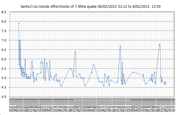
You realize that the blue graph (2nd one) is a larger version of the blue part of the first one?
The red lines and dots in the first one are the Foreshocks before the 7.9 (8.0), and the blue lines are Aftershocks
I thought it was obvious and didn't need explaining.
Geez they had another 7.0 since I made and posted that.
Definitely looking like there is perhaps another 8+ in the offing yet.
If I was on Santa Cruz Is I'd be wanting to evacuate.
.
Oh oh its on the move (maybe)
M5.9 - 75km W of Panguna, Papua New Guinea
earthquake.usgs.gov...
I don't like these new addresses USGS is using
its Bougainville FCS
everyone knows where Bougainville is, its at the north end of the Solomons
Panguna?, didn't have a clue, had to look on the GMaps link
M5.9 - 75km W of Panguna, Papua New Guinea
earthquake.usgs.gov...
I don't like these new addresses USGS is using
its Bougainville FCS
everyone knows where Bougainville is, its at the north end of the Solomons
Panguna?, didn't have a clue, had to look on the GMaps link
edit on 8-2-2013 by muzzy because: (no reason given)
Ok what is going on with New Zealand ???
Friday February 8 2013, 13:53:14 UTC 5 hours ago 5 km south of Christchurch 2.2 0.0 NZ GeoNet Detail
Friday February 8 2013, 13:53:14 UTC 5 hours ago 30 km south-east of Murupara 3.3 0.0 NZ GeoNet Detail
Friday February 8 2013, 13:53:14 UTC 5 hours ago 15 km south of Palmerston North 3.0 0.0 NZ GeoNet Detail
Friday February 8 2013, 13:53:14 UTC 5 hours ago 30 km south-west of Wairoa 3.0 0.0 NZ GeoNet Detail
Friday February 8 2013, 13:53:14 UTC 5 hours ago 100 km south-west of Snares Islands 4.5 0.0 NZ GeoNet Detail
Friday February 8 2013, 13:53:14 UTC 5 hours ago 10 km north-east of Paraparaumu 3.4 0.0 NZ GeoNet Detail
Friday February 8 2013, 13:53:14 UTC 5 hours ago 10 km north-east of Masterton 2.5 0.0 NZ GeoNet Detail
Friday February 8 2013, 13:53:14 UTC 5 hours ago 150 km east of Te Araroa 4.5 0.0 NZ GeoNet Detail
Friday February 8 2013, 13:53:14 UTC 5 hours ago 10 km east of Ruatoria 2.8 0.0 NZ GeoNet Detail
Friday February 8 2013, 13:53:14 UTC 5 hours ago 5 km south-east of Tokomaru Bay 2.2 0.0 NZ GeoNet Detail
Friday February 8 2013, 13:53:14 UTC 5 hours ago 5 km north-east of Wellington 3.6 0.0 NZ GeoNet Detail
Friday February 8 2013, 13:53:14 UTC 5 hours ago 20 km south-west of Gisborne 2.8 0.0 NZ GeoNet Detail
Friday February 8 2013, 13:53:14 UTC 5 hours ago Within 5 km of Hunterville 4.5 0.0 NZ GeoNet Detail
Friday February 8 2013, 13:53:14 UTC 5 hours ago 30 km east of Seddon 3.2 0.0 NZ GeoNet Detail
Friday February 8 2013, 13:53:14 UTC 5 hours ago 5 km south-east of Hunterville 3.3 0.0 NZ GeoNet Detail
Friday February 8 2013, 13:53:14 UTC 5 hours ago 10 km south-east of Christchurch 3.8 0.0 NZ GeoNet Detail
Friday February 8 2013, 13:53:14 UTC 5 hours ago 65 km east of Te Araroa 3.7 0.0 NZ GeoNet Detail
Friday February 8 2013, 13:53:14 UTC 5 hours ago 15 km north-west of Taihape 2.6 0.0 NZ GeoNet Detail
Friday February 8 2013, 13:53:14 UTC 5 hours ago 20 km west of Gisborne 2.8 0.0 NZ GeoNet Detail
Friday February 8 2013, 13:53:14 UTC 5 hours ago 5 km west of Hunterville 2.7 0.0 NZ GeoNet Detail
Friday February 8 2013, 13:53:14 UTC 5 hours ago 5 km north of Porangahau 2.2 0.0 NZ GeoNet Detail
Friday February 8 2013, 13:53:14 UTC 5 hours ago 10 km east of Christchurch 3.3 0.0 NZ GeoNet Detail
Friday February 8 2013, 13:53:14 UTC 5 hours ago 15 km south-west of Whangamata 2.8 0.0 NZ GeoNet Detail
Friday February 8 2013, 13:53:14 UTC 5 hours ago 15 km north of Te Araroa 3.0 0.0 NZ GeoNet Detail
Friday February 8 2013, 13:53:14 UTC 5 hours ago 20 km west of Christchurch 2.6 0.0 NZ GeoNet Detail
Friday February 8 2013, 13:53:14 UTC 5 hours ago 10 km west of Whangamata 3.0 0.0 NZ GeoNet Detail
Friday February 8 2013, 13:53:14 UTC 5 hours ago 5 km north-west of Twizel 2.6 0.0 NZ GeoNet Detail
Friday February 8 2013, 13:53:14 UTC 5 hours ago 10 km north-west of Whanganui 2.7 0.0 NZ GeoNet Detail
Friday February 8 2013, 13:53:14 UTC 5 hours ago 15 km west of Whitianga 3.5 0.0 NZ GeoNet Detail
Friday February 8 2013, 13:53:14 UTC 5 hours ago 15 km north-west of Gisborne 2.4 0.0 NZ GeoNet Detail
Friday February 8 2013, 13:52:12 UTC 6 hours ago 5 km south of Christchurch 2.2 0.0 NZ GeoNet Detail
Friday February 8 2013, 13:52:12 UTC 6 hours ago 30 km south-east of Murupara 3.3 0.0 NZ GeoNet Detail
Friday February 8 2013, 13:52:12 UTC 6 hours ago 5 km south of Christchurch 2.2 0.0 NZ GeoNet Detail
Friday February 8 2013, 13:52:12 UTC 6 hours ago 15 km south of Palmerston North 3.0 0.0 NZ GeoNet Detail
Friday February 8 2013, 13:52:12 UTC 6 hours ago 30 km south-east of Murupara 3.3 0.0 NZ GeoNet Detail
Friday February 8 2013, 13:52:12 UTC 6 hours ago 30 km south-west of Wairoa 3.0 0.0 NZ GeoNet Detail
Friday February 8 2013, 13:52:12 UTC 6 hours ago 15 km south of Palmerston North 3.0 0.0 NZ GeoNet Detail
Friday February 8 2013, 13:52:12 UTC 6 hours ago 100 km south-west of Snares Islands 4.5 0.0 NZ GeoNet Detail
Friday February 8 2013, 13:52:12 UTC 6 hours ago 30 km south-west of Wairoa 3.0 0.0 NZ GeoNet Detail
Friday February 8 2013, 13:52:12 UTC 6 hours ago 10 km north-east of Paraparaumu 3.4 0.0 NZ GeoNet Detail
edit on 7/30/2012 by dreamfox1
because: (no reason given)
edit on 7/30/2012 by dreamfox1 because: quakes.globalincidentmap.com...
reply to post by dreamfox1
Who knows?!, I haven't been there since 02/02/2013
Been concentrating on Santa Cruz and Hokkaido
If the list is
1. more than 10
2. less than 60
3. mags less than 5.0
that is normal, so don't worry about it
I'll do a 7 day update today (address in my signature)
give me a couple of hours.
If there is nothing happening in NZ I usually let it slide for a few days
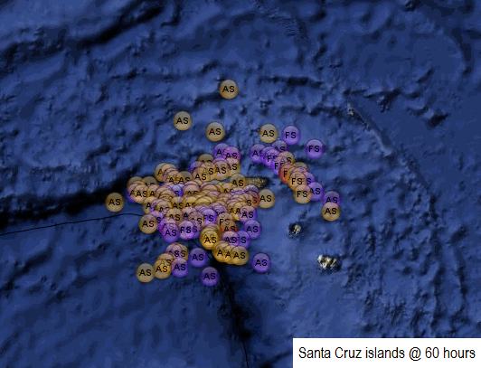
latest graph of Santa Cruz Islands @ 64 1/2 hours
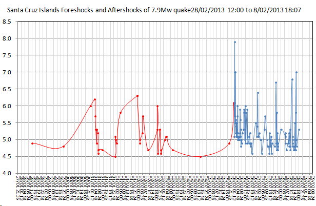
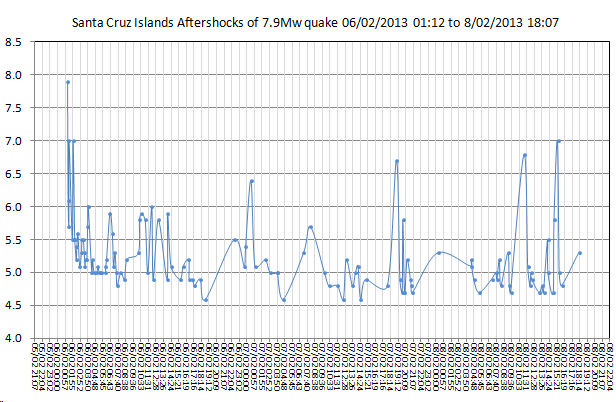
i had to adjust the text on the Y axis as it was getting too tight, as time goes on the graph either
a. gets wider (won't fit in the ATS column without a slide bar)
b. gets tighter (stays the same size and fits)


i had to adjust the text on the Y axis as it was getting too tight, as time goes on the graph either
a. gets wider (won't fit in the ATS column without a slide bar)
b. gets tighter (stays the same size and fits)
reply to post by muzzy
Averages 56 a day. Looks normal to me. Average 48 a day over the past 30 days.
Is that a slight increase? Maybe.
Averages 56 a day. Looks normal to me. Average 48 a day over the past 30 days.
Is that a slight increase? Maybe.
reply to post by PuterMan
is it that high? I hadn't worked out an average.
Just doing the last week now, quite a few on the 8th, 61 events
mag
is it that high? I hadn't worked out an average.
Just doing the last week now, quite a few on the 8th, 61 events
mag
Crikey, this is what happens when you take your eye of your own back yard.
I haven't loaded it to my blog pages yet, but here is a preview of the last 7 days for NZ,
seems activity has moved over to the West Coast, of both islands, those west of the North Island are quite unusual, I wonder if it because of the Santa Cruz activity?
They are all DEEP too.
or it could be Seiscomp3 playing up? (they are all automatic readings yet to be reviewed)
interactive map
edit: just had a closer look day by day, 102 events on the 6th, 35 x mag 3's
looking over the depths each day, those deep quakes started at 05/02/2013 13:08:58UTC and have been constant through to now
the Santa Cruz Mag 8.0 was at 06/02/2013 01:12:23UTC
ya know if it wasn't such a crazy idea I would suggest that there are big chunks of the Pacific Plate (PP) breaking off into the mantle to the west of NZ (under the Australian Plate - AP), and they have created a disturbance in the magma flow all the way up the Norfolk Island Ridge to the weakest point ..... ta da .... Santa Cruz Islands
ie PP pushes under AP west of NZ, then the AP pushes up under the PP at Santa Cuz, like a twisting action.
The only flaw in that theory is why no quakes at Vanuatu/New Hebrides Trench/Loyalty Islands also?
I have never seen so many deep quakes to the west of NZ in such a short span of time, in the 6 years I have been paying attention
just like I have never seen what is going on at Santa Cruz either.
Millennia ago the subduction zone that is now the Kermadec/Tonga Trench was way over west where the Norfolk Island Ridge is now, the whole Fiji,Tonga "hook" has stretched away north-east from there.
Individual maps of each day are now on the first link in my signature.
edit on 8-2-2013 by muzzy because: (no reason given)
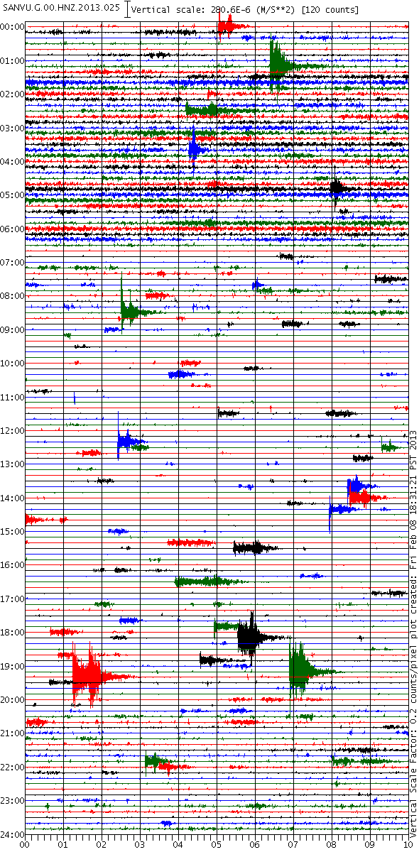
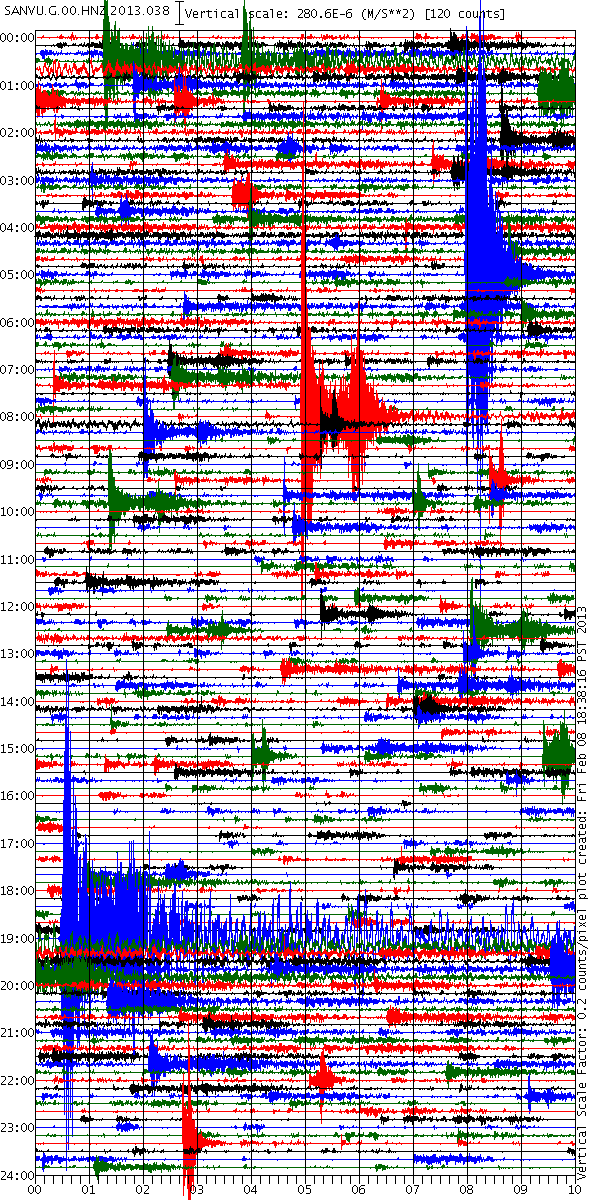
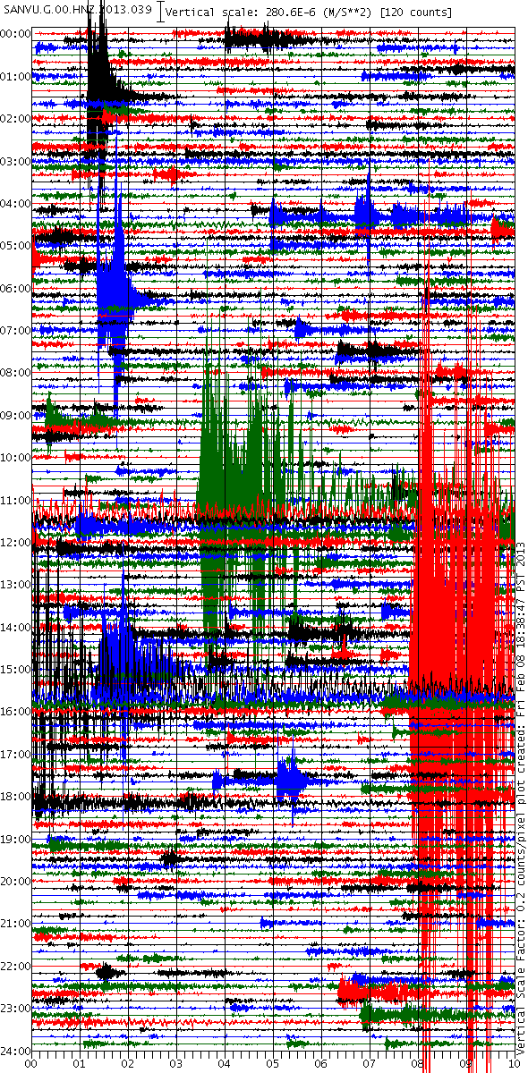
Sequence of seismograms at Santa Cruz
This is off site as the animation is 13MB so be warned this is not suitable for dial-up users.
The seismograms are from the 25th Jan to the 8th Feb inclusive and all at exactly the same visual scale so you get a proper comparison.
Here is a very long scroll. The images are only 45k each s0 this should not stress a dial-up connection too much.
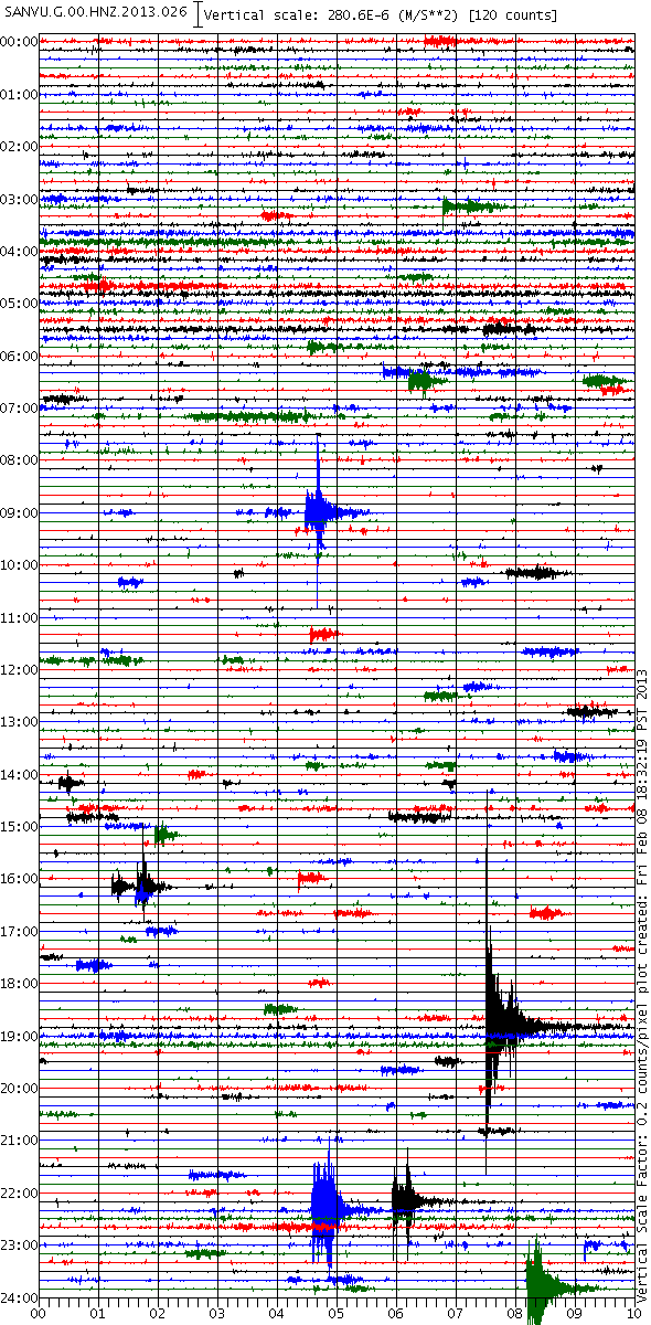
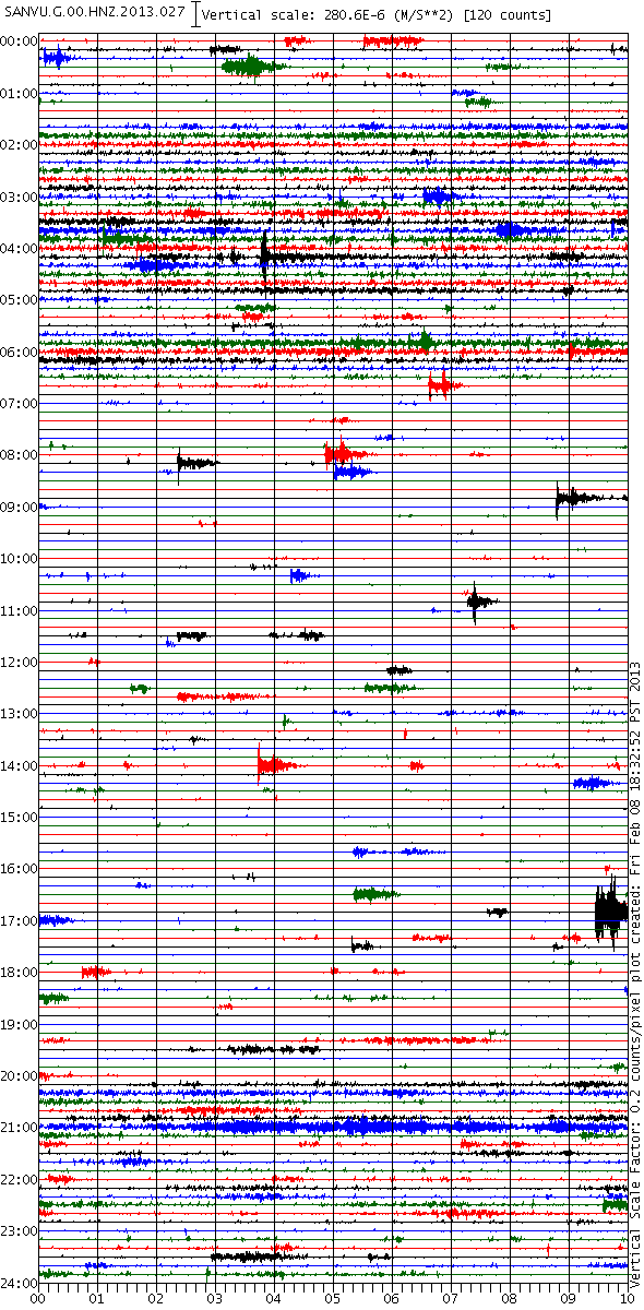
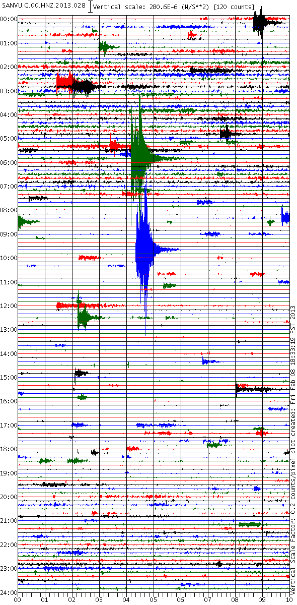
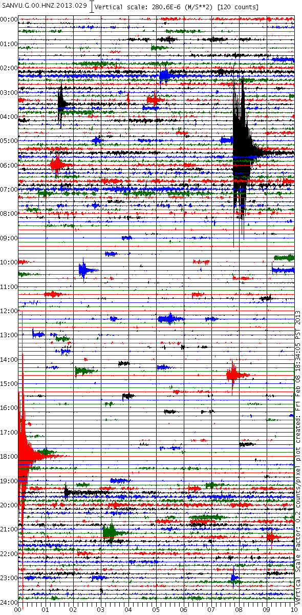
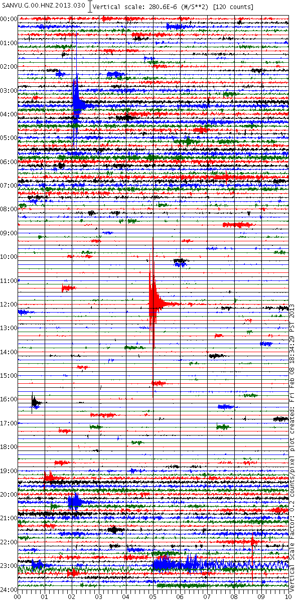
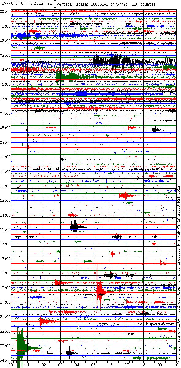
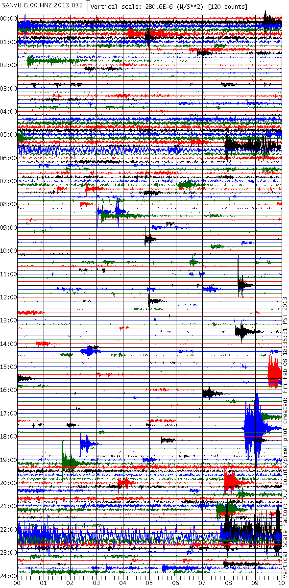
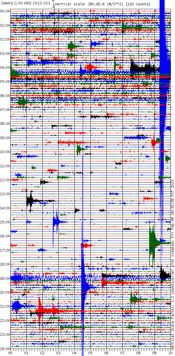
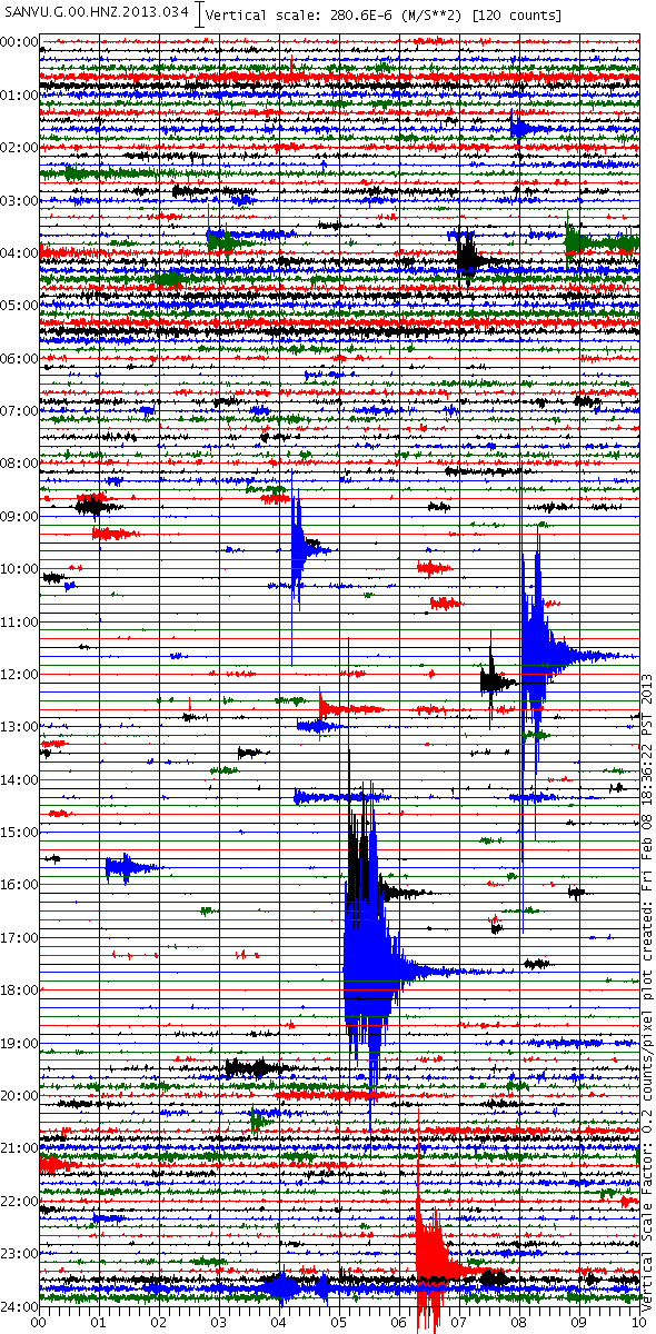
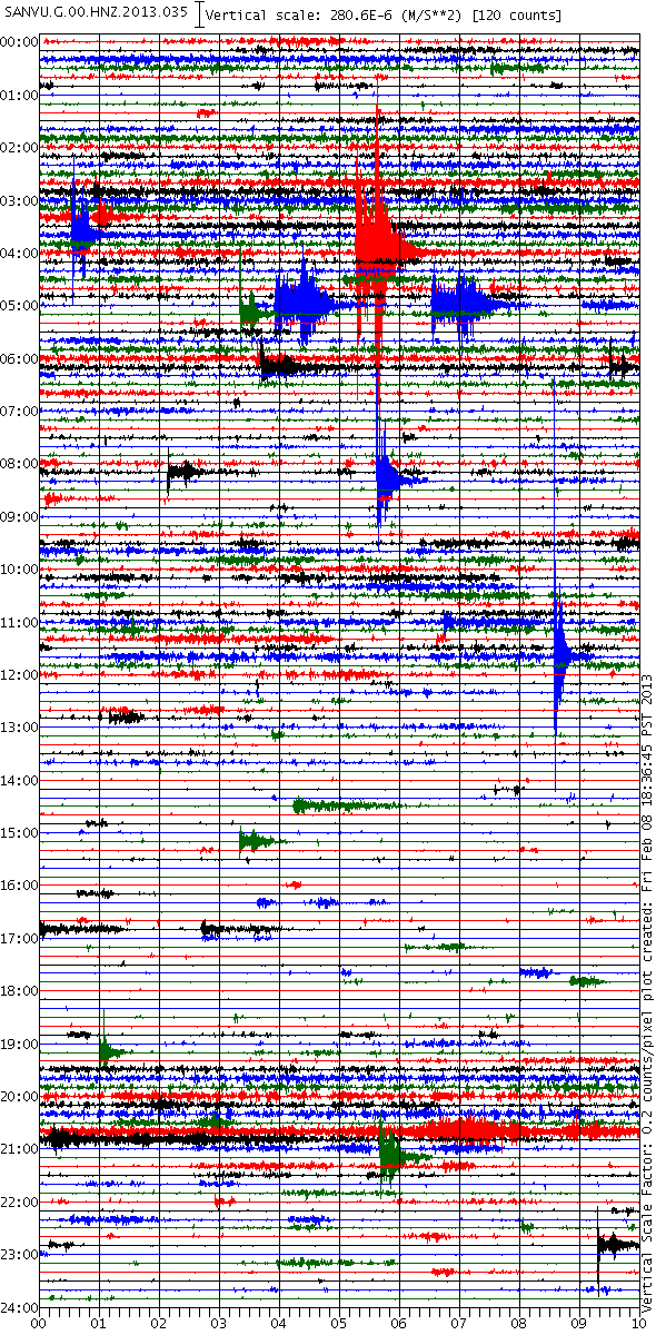
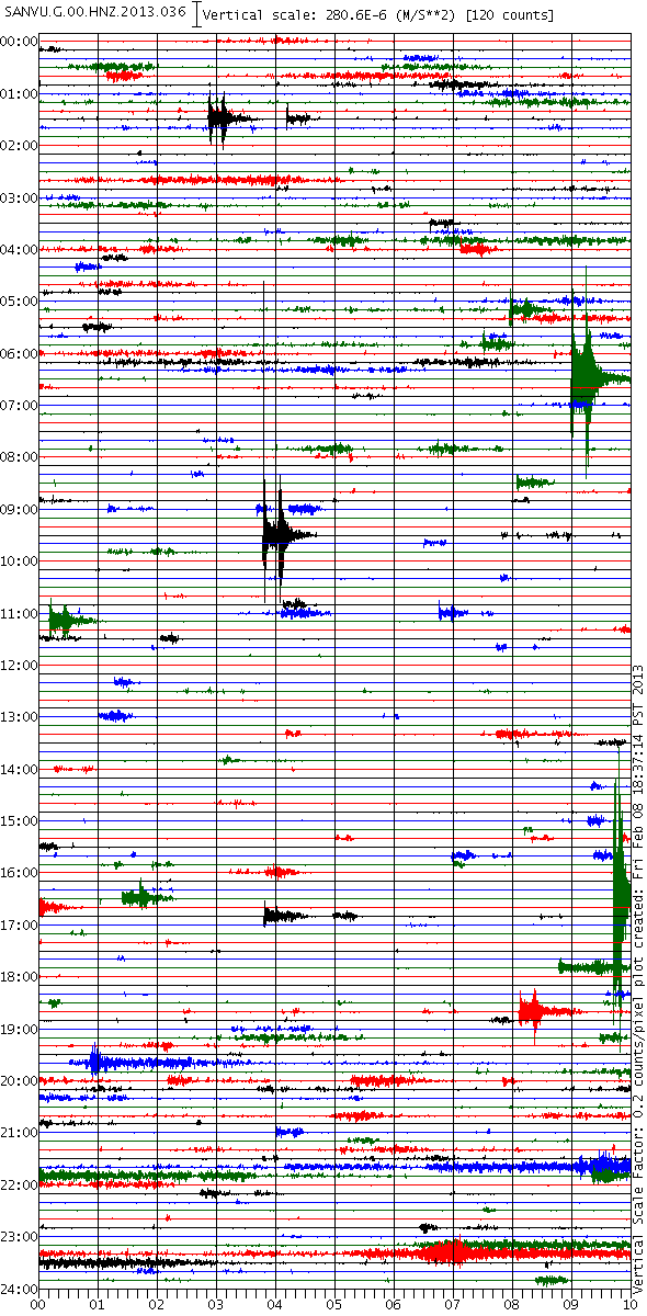
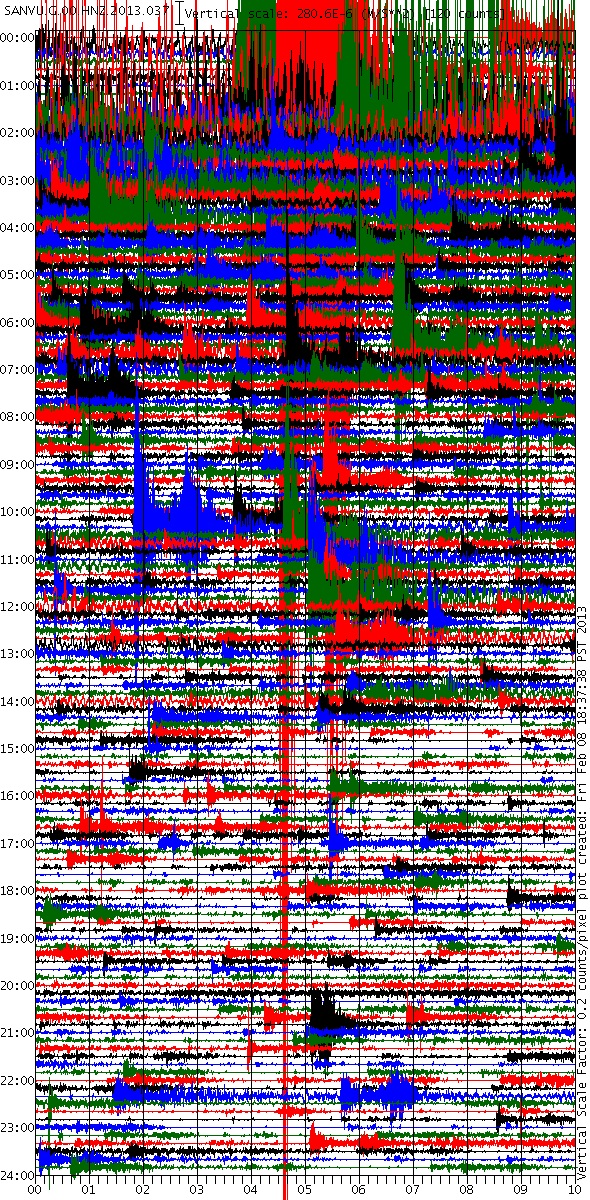


edit on 8/2/2013 by PuterMan because: (no reason given)
new topics
-
Tariffs all around, Except for ...
Predictions & Prophecies: 33 minutes ago -
Gen Flynn's Sister and her cohort blow the whistle on DHS/CBP involvement in child trafficking.
Whistle Blowers and Leaked Documents: 5 hours ago -
Anybody else using Pomodoro time management technique?
General Chit Chat: 7 hours ago -
Bucks County commissioners vote to count illegal ballots in Pennsylvania recount
2024 Elections: 10 hours ago -
Trump sues media outlets -- 10 Billion Dollar lawsuit
US Political Madness: 11 hours ago -
Fired fema employee speaks.
US Political Madness: 11 hours ago
top topics
-
Trump sues media outlets -- 10 Billion Dollar lawsuit
US Political Madness: 11 hours ago, 24 flags -
Bucks County commissioners vote to count illegal ballots in Pennsylvania recount
2024 Elections: 10 hours ago, 21 flags -
How long till it starts
US Political Madness: 12 hours ago, 17 flags -
USSS Agent Fired for Having Sex In Michelle Obama's Bathroom
Politicians & People: 14 hours ago, 10 flags -
Fired fema employee speaks.
US Political Madness: 11 hours ago, 10 flags -
Watching TV
Jokes, Puns, & Pranks: 17 hours ago, 9 flags -
Gen Flynn's Sister and her cohort blow the whistle on DHS/CBP involvement in child trafficking.
Whistle Blowers and Leaked Documents: 5 hours ago, 7 flags -
Anybody else using Pomodoro time management technique?
General Chit Chat: 7 hours ago, 3 flags -
Tariffs all around, Except for ...
Predictions & Prophecies: 33 minutes ago, 0 flags
active topics
-
Tariffs all around, Except for ...
Predictions & Prophecies • 1 • : tamusan -
President-Elect DONALD TRUMP's 2nd-Term Administration Takes Shape.
Political Ideology • 204 • : WeMustCare -
Mike Tyson returns 11-15-24
World Sports • 49 • : underpass61 -
Bucks County commissioners vote to count illegal ballots in Pennsylvania recount
2024 Elections • 19 • : theatreboy -
How long till it starts
US Political Madness • 17 • : WeMustCare -
USSS Agent Fired for Having Sex In Michelle Obama's Bathroom
Politicians & People • 24 • : rickymouse -
The Acronym Game .. Pt.4
General Chit Chat • 962 • : FullHeathen -
TRUMP Could Be Our Modern Day MOSES - The Similarities are Striking.
ATS Skunk Works • 246 • : WeMustCare -
Anybody else using Pomodoro time management technique?
General Chit Chat • 7 • : tamusan -
The Trump effect 6 days after 2024 election
2024 Elections • 141 • : cherokeetroy

