It looks like you're using an Ad Blocker.
Please white-list or disable AboveTopSecret.com in your ad-blocking tool.
Thank you.
Some features of ATS will be disabled while you continue to use an ad-blocker.
share:
reply to post by PuterMan
Hey PM, I made a post about that little line of quakes last week. Here is a link.
It is at Sutter Buttes, a 1.4 million year old volcano, that leaks methane.
Hey PM, I made a post about that little line of quakes last week. Here is a link.
It is at Sutter Buttes, a 1.4 million year old volcano, that leaks methane.
reply to post by PuterMan
Thanks PM, that's all I could find that even remotely resembled what Daughter posted.
Do you still keep sound files cause I would love to hear what that last graphic you posted sounded like?
Thanks PM, that's all I could find that even remotely resembled what Daughter posted.
Do you still keep sound files cause I would love to hear what that last graphic you posted sounded like?
Originally posted by PuterMan
reply to post by Cherryontop
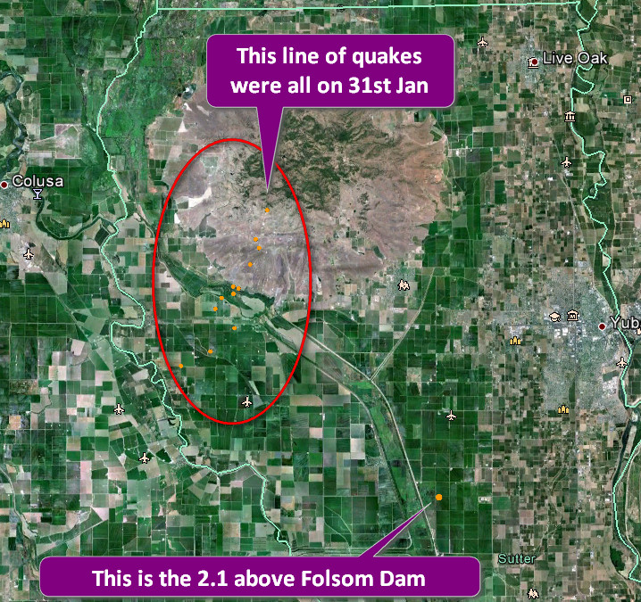
That seems to be about 38 miles from the Folsom dam.
Anyone know what this area is? (Click for slightly bigger image)
edit on 6/2/2013 by PuterMan because: (no reason given)
This seems to explain that area
According to Wiki
:Sutter County is home to the Sutter Buttes, known as the "World's Smallest Mountain Range." This volcanic formation provides relief to the otherwise seemingly flat Sacramento Valley. For further information about the Sutter Buttes go to [1]
en.wikipedia.org...
Bordered by the Sacramento River on the west and the Feather River on the east, Sutter County has 240 miles (390 km) of levees. The Sutter Bypass, which diverts flood waters from the Sacramento River, cuts through the heart of Sutter County
geofon.gfz-potsdam.de...
Mag 6.4
F-E Region: Santa Cruz Islands Region
Time: 2013-02-07 00:30:12.9 UTC
Magnitude: 6.4
Epicenter: 164.84°E 11.70°S
Depth: 10 km
Status: A - automatic
www.emsc-csem.org...
Magnitude M 6.3
Region SANTA CRUZ ISLANDS REGION
Date time 2013-02-07 00:30:12.0 UTC
Location 11.86 S ; 164.77 E
Depth 2 km
Distances 2123 km NE Brisbane (pop 1,843,392 ; local time 10:30:12.4 2013-02-07)
1623 km NW Suva (pop 199,455 ; local time 12:30:12.4 2013-02-07)
480 km NW Luganville (pop 13,397 ; local time 11:30:12.4 2013-02-07)
Location in Google Maps
Derived from Event Data Source: USGS
Powered by QVSData
Mag 6.4
F-E Region: Santa Cruz Islands Region
Time: 2013-02-07 00:30:12.9 UTC
Magnitude: 6.4
Epicenter: 164.84°E 11.70°S
Depth: 10 km
Status: A - automatic
www.emsc-csem.org...
Magnitude M 6.3
Region SANTA CRUZ ISLANDS REGION
Date time 2013-02-07 00:30:12.0 UTC
Location 11.86 S ; 164.77 E
Depth 2 km
Distances 2123 km NE Brisbane (pop 1,843,392 ; local time 10:30:12.4 2013-02-07)
1623 km NW Suva (pop 199,455 ; local time 12:30:12.4 2013-02-07)
480 km NW Luganville (pop 13,397 ; local time 11:30:12.4 2013-02-07)
Magnitude 6.2 - Santa Cruz Islands Region
Location in Google Maps
- Date-Time: Thursday, February 07, 2013 @ 00:30:11 UTC
- Earthquake location: 11.664°S, 164.961°E,
- Earthquake depth: 9.8 km
- Distances:
141km (87mi) SW of Lata, Solomon Islands
490km (304mi) NNW of Luganville, Vanuatu
601km (373mi) ESE of Honiara, Solomon Islands
762km (473mi) NNW of Port-Vila, Vanuatu
1053km (654mi) NNW of We, New Caledonia
- Event ID: usc000f2ul
Derived from Event Data Source: USGS
Powered by QVSData
edit on 6/2/2013 by PuterMan because: (no reason given)
reply to post by PuterMan
I envy people who have old age creeping up on them. It ran me over like a Mac truck and backed up to do it again a couple of years ago.
If everyone who repeated a post already made in a thread this size were banned there would be nobody left here.
Must be old age creeping up on me.
I envy people who have old age creeping up on them. It ran me over like a Mac truck and backed up to do it again a couple of years ago.
If everyone who repeated a post already made in a thread this size were banned there would be nobody left here.
Muzzy or Puterman,
I hope I'm not repeating something you may have already posted. I am curious about the whole scene since dec 2004 starting with Banda Aceh. Since that time, there's been a string of 8's me thinks. April 1 2007 as well, and maybe the two eight's last year are all part of Austrailia's movement. Yes, volcanoes. I can't see how all the activity since 2004 wouldn't cause moving magma.
I wonder how this last ten years compares to the ten years previous. Is the last decade normal when compare to other decades. And I'm refering specifically to the plate from the west off Sumatra over to the east where this last bit happened. I'm sure Muzzy will want to say hey, include NZealand in that mix. Maybe. What do I know?
Oh, got some editting time. I just noticed that just three days prior to the Dec 26, 2004 , 9.1M off Sumatra, on Dec.23, there was an 8.1M on the opposite side of Australia, southwest of New Zealand. Hmm. Then three months later, 8.6M off Sumatra.
2007 had a couple big ones near Sumatra.
What volcanoes are near Sumatra? Krakatoa. Toba. so on and so on.
Can you say, big eruptions over due?
www.nbcnews.com...
edit on 6-2-2013 by
ericblair4891 because: (no reason given)
reply to post by Cherryontop
SANVU 0000hrs to 1000hrs 06 Feb 2013 (2+ Mb download)
This is a FLAC file playable in WinAmp amongst others and is at 1000 times speed because @580km this is just about a teleseism and at lesser speeds it would take too long to play 10 hours and you would not hear most of it.
BTW if I post a spectrogram I always have a sound file available.
reply to post by ericblair4891
I am off to bed and Muzzy is just about arising so I will leave that one to him, unless it is not done tomorrow when I may have a look at it.
@HappyCat - did you get that truck's license plate? You should report it for reckless enagement.
I am off to bed and Muzzy is just about arising so I will leave that one to him, unless it is not done tomorrow when I may have a look at it.
@HappyCat - did you get that truck's license plate? You should report it for reckless enagement.
reply to post by PuterMan
You're the (Puter) Man! Thanks, that was pretty amazing. I downloaded winamp a long time ago just to listen to your files.
You're the (Puter) Man! Thanks, that was pretty amazing. I downloaded winamp a long time ago just to listen to your files.
Originally posted by MariaLida
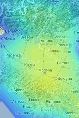
Think this is most dangerous location for Central and Northern Italy, in time ahead or next 70 days ..
Also think in this 70 days we will have strong seizmic activity worldwide and M 8.0 + somewhere at "Ring of Fire" ..
Location for possible EQ of M 5.5 + ..
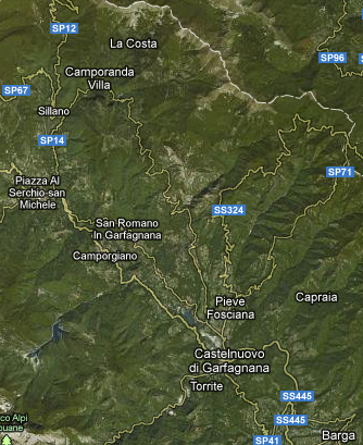
Also think EQ will very probably come somewhere here on this image, around town Barga..
Also have possibility that EQ will appear in next 2-3 days at this location ..
Dead On.... amazing
btw- about the 5.5: From what I've experienced .... a 5.3... they aren't so bad. A lot of shaking, but no visible damage. But I am mostly in an area that has mostly poured cement, or block-built cement houses. Maybe that makes a difference. There were no warning pre-shocks. It lasted probably under 10 seconds.
Like I mentioned, the Duration of the quake I believe is of paramount importance... something that seems to be overlooked most times. A 5.3 for 1 second, or a 5.3 for 10-20 seconds can make all the difference(?)
edit on 6/2/2013 by MarkJS because: (no reason given)
I have no idea why, but somehow I have the feeling, that it is not over yet at the solomons. I would wait a few more days...
edit: btw. it seemed a bit too quiet in Japan today.
edit: btw. it seemed a bit too quiet in Japan today.
edit on 6-2-2013 by aLLeKs because: (no reason given)
1- 8....1-7.....4- 6's.....and 64 5's in a 24 hour period
All I can say is WOW!!
earthquake.usgs.gov...
All I can say is WOW!!
earthquake.usgs.gov...
edit on 6-2-2013 by radpetey because: (no reason given)
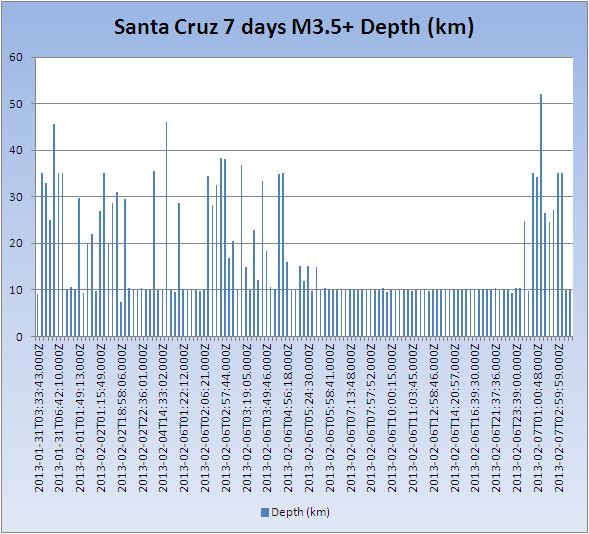
Look at the change in the depth of the last 4-5 aftershocks.
earthquake.usgs.gov...
I wonder if this is anything to worry about.
Never mind...... I now see that there are quite a few more in that range
earthquake.usgs.gov...
I wonder if this is anything to worry about.
Never mind...... I now see that there are quite a few more in that range
edit on 6-2-2013 by radpetey because: (no reason
given)
reply to post by radpetey
Another to add to the collection
Location in Google Maps
Derived from Event Data Source: USGS
Powered by QVSData
I too noticed the depth change. I don't think it means anything if only because I have the feeling that when the rush was on many of those were ??? depths as they are mostly the default depth of 10km. I don't know if they have stations closer than SANVU and HNR but if not there could have been much 'noise' on such teleseismic distances. (Listen to the sounds)
ETA: As someone once said a picture speaks 1000 words......
Another to add to the collection
Magnitude 6.1 - Santa Cruz Islands Region
Location in Google Maps
- Date-Time: Thursday, February 07, 2013 @ 08:03:41 UTC
- Earthquake location: 11.025°S, 164.750°E,
- Earthquake depth: 10.0 km
- Distances:
123km (76mi) WSW of Lata, Solomon Islands
554km (344mi) ESE of Honiara, Solomon Islands
563km (349mi) NNW of Luganville, Vanuatu
836km (519mi) NNW of Port-Vila, Vanuatu
1127km (700mi) NNW of We, New Caledonia
- Event ID: usc000f329
Derived from Event Data Source: USGS
Powered by QVSData
I too noticed the depth change. I don't think it means anything if only because I have the feeling that when the rush was on many of those were ??? depths as they are mostly the default depth of 10km. I don't know if they have stations closer than SANVU and HNR but if not there could have been much 'noise' on such teleseismic distances. (Listen to the sounds)
ETA: As someone once said a picture speaks 1000 words......

edit on 7/2/2013 by PuterMan because: Changed the image as I cut the dates off the bottom which is not very useful!
Magnitude 8.0 Solomon Islands (No stupids - Santa Cruz Islands)
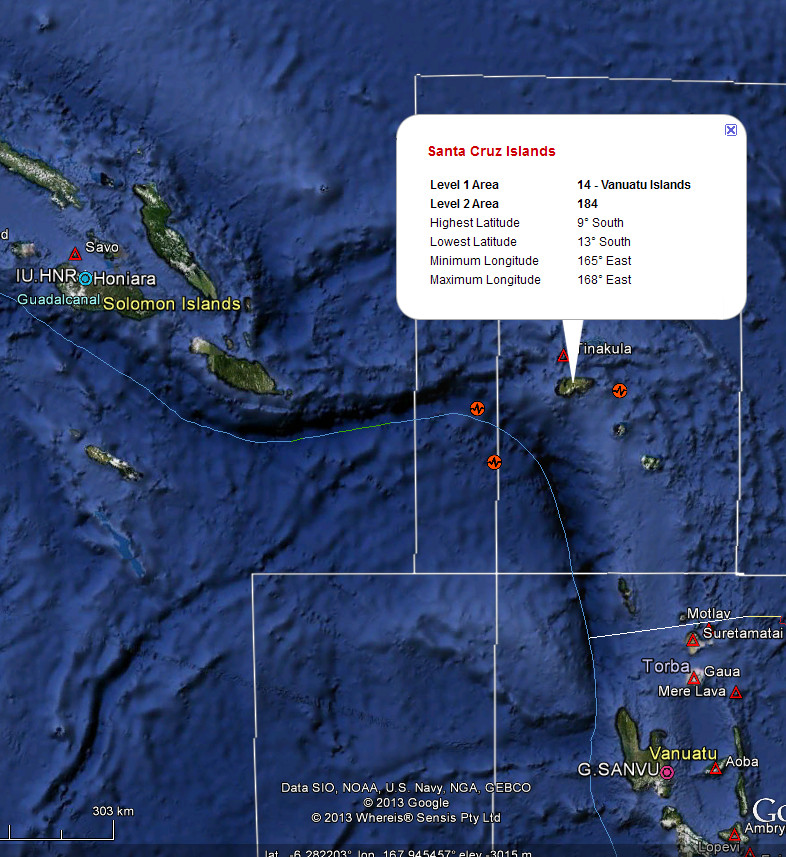
Some details from IRIS if you are interested from Recent Earthquake Teachable Moments which have some data in PDF and PPT form and some TA station videos of the seismic waves passing through.

Some details from IRIS if you are interested from Recent Earthquake Teachable Moments which have some data in PDF and PPT form and some TA station videos of the seismic waves passing through.
Puterman, I think your hunch concerning the 10 km depths being reworked as the seismologists get caught up is right on the money.
Remember back on the 11 and 12 April 2012, after the (2) Sumatra mag 8's, how there seemed to be an outbreak of triggered seismicity around the globe?
We haven't seen anything similar following the Solomon Islands unleashing. In fact, the only Mag 5.0+ eq since the Mag 8.0 that isn't related to Indo-Australian plate movement is this 5.0 on the northern Mid-Atlantic Ridge.
It's as if the rest of the world has taken a nap. Just an observation...
One last thing. Did anyone notice the fault mechanism ascribed to the Mag 7.0 01:54:15 UTC aftershock? (It's the big yellow dot just north of Lata)
Strike-slip rupture at only 9.8 km depth. Whereas, the mainshock was a really shallow-dipping thrust fault with a hypocenter nearly 3 times as deep.
I can't fathom the contorted stresses necessary to cause all these different mechanisms and depths; those rocks are tortured.
ETA: Thanks for linking that PDF, Puterman.
Remember back on the 11 and 12 April 2012, after the (2) Sumatra mag 8's, how there seemed to be an outbreak of triggered seismicity around the globe?
Source
Magnitude 6.9 GULF OF CALIFORNIA April 12, 2012
Magnitude 6.5 MICHOACAN, MEXICO April 11, 2012
Magnitude 5.9 OFF THE COAST OF OREGON April 11, 2012
We haven't seen anything similar following the Solomon Islands unleashing. In fact, the only Mag 5.0+ eq since the Mag 8.0 that isn't related to Indo-Australian plate movement is this 5.0 on the northern Mid-Atlantic Ridge.
It's as if the rest of the world has taken a nap. Just an observation...
One last thing. Did anyone notice the fault mechanism ascribed to the Mag 7.0 01:54:15 UTC aftershock? (It's the big yellow dot just north of Lata)
Strike-slip rupture at only 9.8 km depth. Whereas, the mainshock was a really shallow-dipping thrust fault with a hypocenter nearly 3 times as deep.
I can't fathom the contorted stresses necessary to cause all these different mechanisms and depths; those rocks are tortured.
ETA: Thanks for linking that PDF, Puterman.
edit on 2/7/2013 by Olivine because: (no reason given)
Originally posted by aLLeKs
I have no idea why, but somehow I have the feeling, that it is not over yet at the solomons. I would wait a few more days...
edit: btw. it seemed a bit too quiet in Japan today.edit on 6-2-2013 by aLLeKs because: (no reason given)
All:
I don't know if I'm fabricating a memory trace or recalling one.
IIRC, there was some sort of prediction or prophecy sometime in the last 5-10 years that when there was an extra large intensity quake in the Solomon Islands area, NOT TOO LONG AFTERWARDS there would be a very devastating quake either in Japan or the Left Coast of the USA.
Does anyone else recall something similar?
If I had to guess if this would be possible, I would say yes.... it seems really really quiet in Japan, but since I am only watching USGS, just
because I have no time to watch other sites too, I have no clue if this is true.
But USGS tells me, that there was only one quake (bigger 2.5) in Japan within the last two days... this seems scary, but I can be wrong
edit: seems like jma has some quakes. still very quiet.
But USGS tells me, that there was only one quake (bigger 2.5) in Japan within the last two days... this seems scary, but I can be wrong
edit: seems like jma has some quakes. still very quiet.
edit on 7-2-2013 by aLLeKs because: (no reason given)
reply to post by aLLeKs
typical, I track Japan for a month and no one seems interested so I stop bothering and then you go ask that question
from NIED (most recent data 10 minutes ago)
7/02/2013 5:26 to 8/02/2013 03:07 JST
270 events
7 x 3's
looks pretty normal
text file of that
last post on 31-1-2013 @ 06:13 AM
Japan Preliminary Earthquake Maps NIED
edit on 7-2-2013 by muzzy because: (no reason given)
edit on 7-2-2013 by muzzy because: put in the wrong tmes
new topics
-
Gen Flynn's Sister and her cohort blow the whistle on DHS/CBP involvement in child trafficking.
Whistle Blowers and Leaked Documents: 2 hours ago -
Anybody else using Pomodoro time management technique?
General Chit Chat: 5 hours ago -
Bucks County commissioners vote to count illegal ballots in Pennsylvania recount
2024 Elections: 7 hours ago -
Trump sues media outlets -- 10 Billion Dollar lawsuit
US Political Madness: 8 hours ago -
Fired fema employee speaks.
US Political Madness: 9 hours ago -
How long till it starts
US Political Madness: 10 hours ago
top topics
-
Trump sues media outlets -- 10 Billion Dollar lawsuit
US Political Madness: 8 hours ago, 23 flags -
Bucks County commissioners vote to count illegal ballots in Pennsylvania recount
2024 Elections: 7 hours ago, 19 flags -
How long till it starts
US Political Madness: 10 hours ago, 17 flags -
Watching TV
Jokes, Puns, & Pranks: 14 hours ago, 9 flags -
USSS Agent Fired for Having Sex In Michelle Obama's Bathroom
Politicians & People: 12 hours ago, 9 flags -
Fired fema employee speaks.
US Political Madness: 9 hours ago, 9 flags -
Gen Flynn's Sister and her cohort blow the whistle on DHS/CBP involvement in child trafficking.
Whistle Blowers and Leaked Documents: 2 hours ago, 6 flags -
Anybody else using Pomodoro time management technique?
General Chit Chat: 5 hours ago, 3 flags
active topics
-
Trump picks Gov. Kristi Noem to serve as homeland security secretary
2024 Elections • 44 • : Solvedit -
The Trump effect 6 days after 2024 election
2024 Elections • 139 • : Astrocometus -
Trump sues media outlets -- 10 Billion Dollar lawsuit
US Political Madness • 44 • : Lumenari -
USSS Agent Fired for Having Sex In Michelle Obama's Bathroom
Politicians & People • 23 • : schuyler2 -
Watching TV
Jokes, Puns, & Pranks • 2 • : texas thinker -
-@TH3WH17ERABB17- -Q- ---TIME TO SHOW THE WORLD--- -Part- --44--
Dissecting Disinformation • 3278 • : WeMustCare -
President-elect TRUMP Picks MATT GAETZ for his ATTORNEY GENERAL - High Level PANIC Ensues.
2024 Elections • 76 • : marg6043 -
How long till it starts
US Political Madness • 15 • : WeMustCare -
Post A Funny (T&C Friendly) Pic Part IV: The LOL awakens!
General Chit Chat • 7776 • : baddmove -
President-Elect DONALD TRUMP's 2nd-Term Administration Takes Shape.
Political Ideology • 201 • : WeMustCare

