It looks like you're using an Ad Blocker.
Please white-list or disable AboveTopSecret.com in your ad-blocking tool.
Thank you.
Some features of ATS will be disabled while you continue to use an ad-blocker.
share:
another 5.5 showing on usgs for same spot Honshu..
that's a 5.5, 4.8 and 5.1 in the same spot since the quake.
that's a 5.5, 4.8 and 5.1 in the same spot since the quake.
edit on 25-10-2013 by zeetroyman because: (no reason given)
reply to post by zeetroyman
Video footage...quite spooky and eerie at Fukushima plant
www.youtube.com...=96
Rainbows
Jane
Video footage...quite spooky and eerie at Fukushima plant
www.youtube.com...=96
Rainbows
Jane
angelchemuel
reply to post by zeetroyman
Video footage...quite spooky and eerie at Fukushima plant
www.youtube.com...=96
Rainbows
Jane
The garbage quality of that video makes one wonder what they don't want the public to see. I have owned entry level pro digital cameras and camcorders that have much better picture quality than that.
been away all day, heard it on the radio earlier though
just had a look on NIED Hi-net
Lat/Long: 37.204 144.5851
UTC: 25/10/2013 17:10:19
JST: 26/10/2013 2:10
Depth: 54.5
Mag: 7.7 ML
Location: Off East Coast Of Honshu. Japan
Status: Preliminary
Energy Released: 5,350,671.93730 tonnes of TNT
here is an interactive map of all the earthquakes in Japan since the 7.7
I only count 8 in the immediate area.
not many.
map
reply to post by muzzy
Hmmmmmmmmm . . . Japan sure seems . . . slated for some more "interesting times" . . . though actually . . . all of us are.
Hmmmmmmmmm . . . Japan sure seems . . . slated for some more "interesting times" . . . though actually . . . all of us are.
reply to post by happykat39
Yup and you'd certainly expect the Japanese to have that technology!
I would love an explanation as to what those 'things' are that appear to drop into the area, also what's with the constant distortion of the buildings window until the end of the vid? This is why I used the word spooky in my original post of this vid.
Rainbows
Jane
Latest version of the IRIS IEB URL Builder is now available. Version 1.4.0
Build 5 (1.4.5.0)
The link above goes to the help file updated today which has links to the download.
Main addition in this version is epicentre input and the browser selection is fixed.
The link above goes to the help file updated today which has links to the download.
Main addition in this version is epicentre input and the browser selection is fixed.
reply to post by happykat39
Even at night?
Seems quite good for night time to me, but then I don't know much about web cams.
The garbage quality of that video makes one wonder what they don't want the public to see. I have owned entry level pro digital cameras and camcorders that have much better picture quality than that.
Even at night?
Seems quite good for night time to me, but then I don't know much about web cams.
25-10-2013 M7.3 matched with M9.0-11/03/2011 aftershocks 72hrs
M9 marked with finger
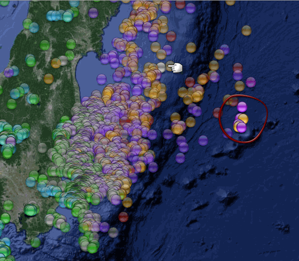
using Putermans new IEB epicentre location tool Version 1.4.5.0 (1 degree spread)
MUZZY MAP,
M7.3 marked with finger
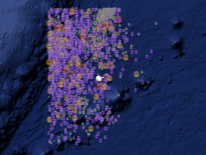
3DV DOWN
M7.3 marked with finger
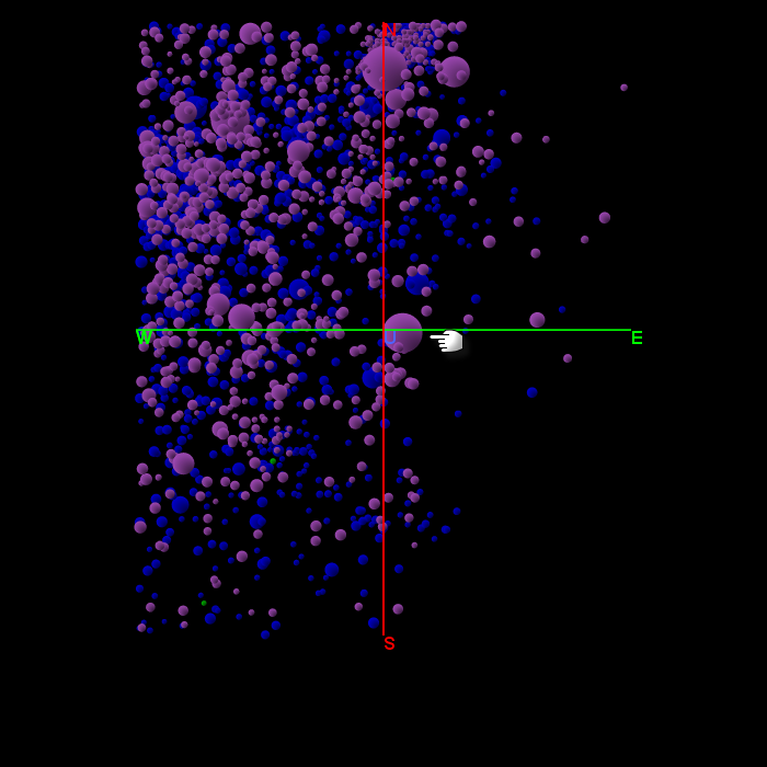
3DV NORTH CROSS SECTION
M7.3 marked with finger
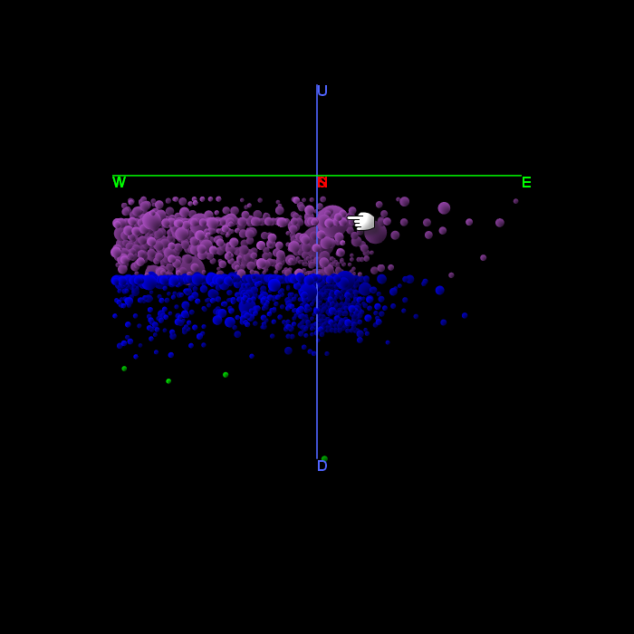
M9 marked with finger

using Putermans new IEB epicentre location tool Version 1.4.5.0 (1 degree spread)
MUZZY MAP,
M7.3 marked with finger

3DV DOWN
M7.3 marked with finger

3DV NORTH CROSS SECTION
M7.3 marked with finger

edit on 10u29829813 by muzzy because: (no reason given)
edit on 10u29829813 by muzzy because: (no reason given)
Interactive Map of those IRIS recorded events Japan 7.3 area History
Looks like Google Maps have finally allowed scaled Icons on the interactive maps, you never used to be able to do that, they used to all come out the same size and the smaller ones were the same size as the standard 32x32 pixel size but were blurred.
Well done Google, you finally done something people actually want!
I don't know if I should change the base scaling on all my maps, its easily done, but may look funny on the M7+ maps as the pink markers will all be 133% size and swamp the small size map on the pages.
edit:
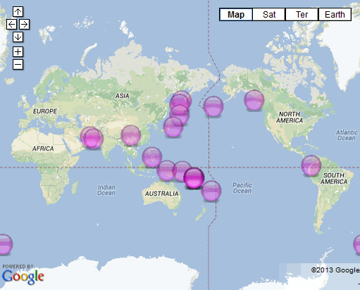
here is a comparison
M7+ project 2013 year standard icons
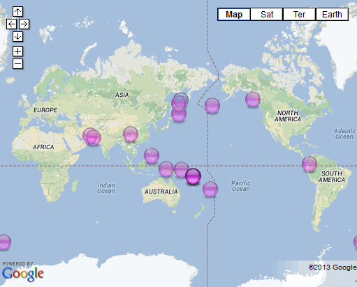
M7+ project 2013 yearscaled icons
and here is New Zealand daily map comparison 24/10/2013
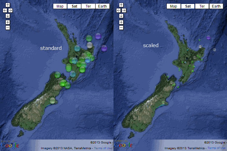
personally I don't like the scaled icons, especially for NZ, what do you people think?
I might just use them for IRIS maps, so they match in with 3DV, as in the above post about Japan. Probably would work with my regular Japan maps too, with 300+ events per day it gets a bit crowded, but not sure how I could do that without changing the scale right across the board I sure ain't redoing Japan on its own, there are 24,825 icons on 2013 alone, and thats only up till April 22nd!
edit2:
and here is Japan compared Jan 1st 2013, 179 icons/events
it looks easier on the eye if it is in terrain style rather than map view eh?, less clutter with the labels
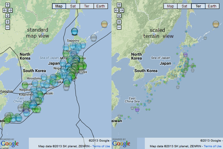
Too bad they don't have a "Poll" facility on ATS, I could run a Poll and folks could vote for their preference, I do take note of readers preferences.
edit3:
What the scaling DOES do is let you see instantly where the bigger quakes are at on the map, like on this Japan week one 2013 page.
HOWEVER, when you zoom IN from that scale on the map, you lose the position of the the icon because of the green background and the small size of it ( and they can get confused with town markers too)
Looks like Google Maps have finally allowed scaled Icons on the interactive maps, you never used to be able to do that, they used to all come out the same size and the smaller ones were the same size as the standard 32x32 pixel size but were blurred.
Well done Google, you finally done something people actually want!
I don't know if I should change the base scaling on all my maps, its easily done, but may look funny on the M7+ maps as the pink markers will all be 133% size and swamp the small size map on the pages.
edit:
here is a comparison
M7+ project 2013 year standard icons

M7+ project 2013 yearscaled icons

and here is New Zealand daily map comparison 24/10/2013

personally I don't like the scaled icons, especially for NZ, what do you people think?
I might just use them for IRIS maps, so they match in with 3DV, as in the above post about Japan. Probably would work with my regular Japan maps too, with 300+ events per day it gets a bit crowded, but not sure how I could do that without changing the scale right across the board I sure ain't redoing Japan on its own, there are 24,825 icons on 2013 alone, and thats only up till April 22nd!
edit2:
and here is Japan compared Jan 1st 2013, 179 icons/events
it looks easier on the eye if it is in terrain style rather than map view eh?, less clutter with the labels

Too bad they don't have a "Poll" facility on ATS, I could run a Poll and folks could vote for their preference, I do take note of readers preferences.
edit on 10u29829813 by muzzy because: (no reason given)
edit3:
What the scaling DOES do is let you see instantly where the bigger quakes are at on the map, like on this Japan week one 2013 page.
HOWEVER, when you zoom IN from that scale on the map, you lose the position of the the icon because of the green background and the small size of it ( and they can get confused with town markers too)
edit on 10u29829813 by muzzy because: thank you for your time in this matter, I'll think
about it some more before going ahead with any changes.
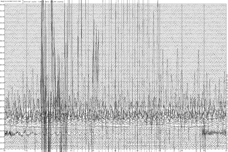
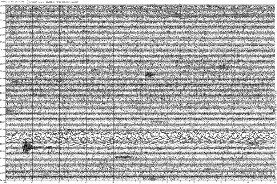
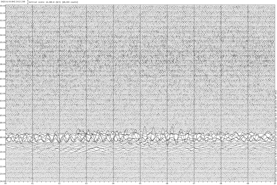
Some graphs of the 7.3Mw off the Coast of Honshu 26/10/2013 UTC
MAJO - Matsushiro, Nagano, Honshu. 579.2 km WSW
(click image for full size version, opens in new tab/window)
RAO - Raoul, Kermadec Islands. 8354 km SSE
(click image for full size version, opens in new tab/window)
SNZO - South Karori, New Zealand, 9248 km SSE
(click image for full size version, opens in new tab/window)
MAJO - Matsushiro, Nagano, Honshu. 579.2 km WSW
(click image for full size version, opens in new tab/window)

RAO - Raoul, Kermadec Islands. 8354 km SSE
(click image for full size version, opens in new tab/window)

SNZO - South Karori, New Zealand, 9248 km SSE
(click image for full size version, opens in new tab/window)

reply to post by muzzy
Muzzy, all good work. It all looks nice and complicated and very pretty. But to be honest It makes little sense to me. I know you have put a great deal of work into it and I appreciate that enormously. I prefer your earlier efforts. BTW, are you sure people are not looking at your earlier work and taking it one step forward because they have the budget to do it?
Now, is this 7.3 a foreshock for another really big one. That is the critical question at this time. Your views?
Thanks in advance.
P
reply to post by PuterMan
THX THX.
Will have to study your excellent instructions more to find the drop down menu of already loaded locations. LOL.
Wonderful work.
THX THX.
Will have to study your excellent instructions more to find the drop down menu of already loaded locations. LOL.
Wonderful work.
reply to post by pheonix358
With my neck in the guillotine I say NO!
The chance of another great earthquake, i.e.8+, here in the near future is extremely slim.
Now, is this 7.3 a foreshock for another really big one. That is the critical question at this time. Your views?
With my neck in the guillotine I say NO!
The chance of another great earthquake, i.e.8+, here in the near future is extremely slim.
reply to post by BO XIAN
Minor fix to the program. I discovered that if you enter 2 decimal values for the epicentre, i.e. without N S E W, separated with a comma the program actually returns blank to both fields.
IEBUrlBuilder_1-4-5-1_setup.zip
Minor fix to the program. I discovered that if you enter 2 decimal values for the epicentre, i.e. without N S E W, separated with a comma the program actually returns blank to both fields.
IEBUrlBuilder_1-4-5-1_setup.zip
reply to post by PuterMan
THX THX for your 'tireless' work for all of us.
Wonderful.
Will download the update.
THX THX for your 'tireless' work for all of us.
Wonderful.
Will download the update.
reply to post by pheonix358
Thanks, OK then that is 2 votes for retaining the old standard size icons, mine is the other one
No I don't think this is a foreshock of anything too traumatic in the immediate future, its way out on the Pacific Plate and is probably due to compression of that plate as it crunches up against the North American Plate or as the downward edge gets pulled under Japan. All the foreshocks, and the main shock of the 2011 M9 were on the North American Plate, just a few of the aftershocks were in this area (see the interactive map I did)
you can see the Wati-Bene zone shape on this cross section ( hover on View/Look, then click on North
I notice NIED had the depth at 54.5km whereas IRIS and JMA have it at 10km
edit on 10u29929913 by muzzy because: (no reason given)
reply to post by muzzy
Hi!
Where is everybody???
Lately this thread is treated just like a parent of grown children...
Nobody comes around unless they want or need something,
or 'something' has happened!!! Bwahahaha!
But at least they do still come around once in a while!
Anyway, only time for turbo lurking lately!
My 2 cent vote is for the standard.
WOQ
reply to post by wasobservingquietly
Some of us check the thread regularly but don't always have anything meaningful enough to contribute to bother with a post that's not a "quality post."
And Muzzy and Puterman . . . quake jockey's extraordinaire . . . do quite well without my blather distracting from their great work. LOL.
Some of us check the thread regularly but don't always have anything meaningful enough to contribute to bother with a post that's not a "quality post."
And Muzzy and Puterman . . . quake jockey's extraordinaire . . . do quite well without my blather distracting from their great work. LOL.
new topics
-
Bizarre Labour Party Tic Toc Video Becomes Even More Embarrassing
Regional Politics: 25 minutes ago -
Potter to WHU
World Sports: 6 hours ago -
Dr. Demento
Music: 7 hours ago -
The elephant in the room (wearing a hoodie)
US Political Madness: 8 hours ago
top topics
-
The elephant in the room (wearing a hoodie)
US Political Madness: 8 hours ago, 14 flags -
To become president, Zelensky had to learn Ukrainian
Political Conspiracies: 14 hours ago, 8 flags -
Dr. Demento
Music: 7 hours ago, 6 flags -
Potter to WHU
World Sports: 6 hours ago, 2 flags -
Bizarre Labour Party Tic Toc Video Becomes Even More Embarrassing
Regional Politics: 25 minutes ago, 2 flags
active topics
-
Los Angeles brush fires latest: 2 blazes threaten structures, prompt evacuations
Mainstream News • 191 • : xuenchen -
Bizarre Labour Party Tic Toc Video Becomes Even More Embarrassing
Regional Politics • 1 • : chiefsmom -
President Carter has passed
Mainstream News • 49 • : Oldcarpy2 -
The Fight for Election Integrity Continues -- Audits, Criminal Investigations, Legislative Reform
2024 Elections • 4372 • : IndieA -
What Comes After January 20th
Mainstream News • 35 • : JadedGhost -
Potter to WHU
World Sports • 3 • : gortex -
The Truth about Migrant Crime in Britain.
Social Issues and Civil Unrest • 42 • : gortex -
Post A Funny (T&C Friendly) Pic Part IV: The LOL awakens!
General Chit Chat • 8007 • : underpass61 -
Planned Civil War In Britain May Be Triggered Soon
Social Issues and Civil Unrest • 29 • : AdultMaleHumanUK -
The elephant in the room (wearing a hoodie)
US Political Madness • 19 • : xuenchen

