It looks like you're using an Ad Blocker.
Please white-list or disable AboveTopSecret.com in your ad-blocking tool.
Thank you.
Some features of ATS will be disabled while you continue to use an ad-blocker.
share:
reply to post by muzzy
" iridium, a heavy metal rare " is this one of those ,,"rare earth metals?",, cause just curious,
" iridium, a heavy metal rare " is this one of those ,,"rare earth metals?",, cause just curious,
Disclaimer: I have no idea about EQ's and come here to learn from our residential professionals.
I was watching my "Breaking Stories" Feed and I noticed 4-5 hours in that I kept seeing EQ's on the hour almost. So, I went to USGS website and there is quite a few 2+ occurring every hour around the world. Cali, Mexico, a Country I can't say let alone spell (haha)
Anyways... Look at all of them-- is this normal?? Errrr I know a lot of EQ's happen daily, weekly, monthly...
I'm ust wondering if on the hour, at these locations is normal?
Thank-you Educators! (w)
USGS latest
Are we in Low tide at the moment.
Clock showing 5:11 pm Pacific time
Huntington beach cam is showing a unusual low tide .
Beach cam Noth of Pier
Dont see anything on the Tsunami Warning Center.
and the same on the south cam.???
Clock showing 5:11 pm Pacific time
Huntington beach cam is showing a unusual low tide .
Beach cam Noth of Pier
Dont see anything on the Tsunami Warning Center.
and the same on the south cam.???
edit on 7/30/2012 by dreamfox1 because: wcatwc.arh.noaa.gov...
The small swarm of quakes north of Twentynine Palms, CA (labeled 'N of Joshua Tree' on the USGS recent quake
map has piqued my interest, so I've done some
digging.
(These are the quakes BobatHome is showing on the ABC7 seismo drum)
This map, made using the IRIS Earthquake Browser, shows the mag 5+ earthquakes in the general area, going back to 1979. I labeled the events I found relevant; almost all the others are aftershocks of the Landers & Hector Mine quakes.
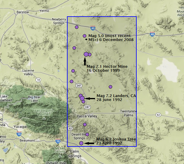
The Joshua Tree quake hit in April 1992, two months later southern California was hit by the largest quake in 40 years, the Landers earthquake. It ruptured the ground surface in many areas along its total rupture length of 85 kms.
Seven years later, the Hector Mine earthquake struck.
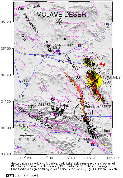
According to the SCEC, the Hector Mine eq epicenter was the same spot as a tight cluster of aftershocks from the Landers quake. (See image below--sourced from link above.)
The Hector Mine quake was also proceeded by 12 foreshocks (largest was mag 3.8)in the 20 hours before the mainshock.
There were hundreds of aftershocks from the Hector Mine quake. The map below shows all of the earthquakes since 1 January 2000 in the region of the Hector Mine quake, and the swarm from today.
(I skipped the bulk of the aftershocks in the 2.5 months after the mainshock because it overwhelms the map. )
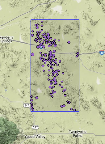
This link gives the table of quakes listed on the map above, sorted by date, with most recent first.
As you can see on the table, the aftershocks have slowly subsided over the past 14 years.
Until this week.
There were 3 small quakes on October 3rd: a mag 1.5, 2.1, & 1.8.
Then today's action kicked off with the mag 4.3, and was followed by 20 smaller earthquakes, so far.
So I'm wondering if this swarm is a precursor to another moderate/large earthquake in this area.
This area is known as the Eastern California Shear Zone, the far southern end of the Walker Lane, which accommodates 15-25% of the motion between the Pacific plate and the North American plate. The San Andreas takes up the other 75-85%.
Is this activity pointing toward a larger quake soon? Maybe?
(These are the quakes BobatHome is showing on the ABC7 seismo drum)
This map, made using the IRIS Earthquake Browser, shows the mag 5+ earthquakes in the general area, going back to 1979. I labeled the events I found relevant; almost all the others are aftershocks of the Landers & Hector Mine quakes.

The Joshua Tree quake hit in April 1992, two months later southern California was hit by the largest quake in 40 years, the Landers earthquake. It ruptured the ground surface in many areas along its total rupture length of 85 kms.
Seven years later, the Hector Mine earthquake struck.
According to the SCEC, the Hector Mine eq epicenter was the same spot as a tight cluster of aftershocks from the Landers quake. (See image below--sourced from link above.)
The Hector Mine quake was also proceeded by 12 foreshocks (largest was mag 3.8)in the 20 hours before the mainshock.

There were hundreds of aftershocks from the Hector Mine quake. The map below shows all of the earthquakes since 1 January 2000 in the region of the Hector Mine quake, and the swarm from today.
(I skipped the bulk of the aftershocks in the 2.5 months after the mainshock because it overwhelms the map. )

This link gives the table of quakes listed on the map above, sorted by date, with most recent first.
As you can see on the table, the aftershocks have slowly subsided over the past 14 years.
Until this week.
There were 3 small quakes on October 3rd: a mag 1.5, 2.1, & 1.8.
Then today's action kicked off with the mag 4.3, and was followed by 20 smaller earthquakes, so far.
So I'm wondering if this swarm is a precursor to another moderate/large earthquake in this area.
This area is known as the Eastern California Shear Zone, the far southern end of the Walker Lane, which accommodates 15-25% of the motion between the Pacific plate and the North American plate. The San Andreas takes up the other 75-85%.
Is this activity pointing toward a larger quake soon? Maybe?
edit on 10/6/2013 by Olivine because: fix a link
2nd 6 magnitude today, USGS underestimate of 0.9 magnitude value 5.3mb
Mw 6, 6.2
www.globalcmt.org/cgi-bin/globalcmt-cgi-bin/CMT4/form?itype=ymd&yr=2013&mo=10&day=6&oyr=1976&omo=1&oday=1&jyr=1976&jday=1&ojyr=1976&ojday=1&otype =nd&nday=1&lmw=0&umw=10&lms=0&ums=10&lmb=0&umb=10&llat=-90&ulat=90&llon=-180&ulon=180&lhd=0&uhd=1000<s=-9999&uts=9999&lpe1=0&upe1=90&lpe2=0&upe2=90& list=0
LDEO 3 UTC/GMT 2013-10-07 update.
posting full 7 day moving wall for archival/backup. some oceanic events missed this week.
www.ldeo.columbia.edu/~ekstrom/Research/SWD/current/RADB_SWD_grd.html
earthquake.usgs.gov/earthquakes/eventpage/usb000k7s0
Mw 6, 6.2
www.globalcmt.org/cgi-bin/globalcmt-cgi-bin/CMT4/form?itype=ymd&yr=2013&mo=10&day=6&oyr=1976&omo=1&oday=1&jyr=1976&jday=1&ojyr=1976&ojday=1&otype =nd&nday=1&lmw=0&umw=10&lms=0&ums=10&lmb=0&umb=10&llat=-90&ulat=90&llon=-180&ulon=180&lhd=0&uhd=1000<s=-9999&uts=9999&lpe1=0&upe1=90&lpe2=0&upe2=90& list=0
LDEO 3 UTC/GMT 2013-10-07 update.
posting full 7 day moving wall for archival/backup. some oceanic events missed this week.
www.ldeo.columbia.edu/~ekstrom/Research/SWD/current/RADB_SWD_grd.html
2013 10 6 21 33 20.0 -36.75 -97.75 33.0 6.2 WEST CHILE RISE
2013 10 6 21 18 48.0 -19.75 169.25 33.0 5.1 VANUATU ISLANDS
2013 10 6 17 20 40.0 -53.50 140.50 33.0 5.2 WEST OF MACQUARIE ISLAND
2013 10 6 16 38 16.0 12.25 141.75 33.0 6.2 SOUTH OF MARIANA ISLANDS
2013 10 6 15 10 56.0 17.25 -100.25 33.0 5.1 GUERRERO, MEXICO
2013 10 6 14 27 52.0 17.25 -100.25 33.0 5.0 GUERRERO, MEXICO
2013 10 6 8 3 12.0 -33.50 77.50 33.0 4.7 MID-INDIAN RIDGE
2013 10 6 1 37 28.0 45.50 26.50 33.0 5.5 ROMANIA
2013 10 5 14 35 20.0 -30.75 -177.75 33.0 4.9 KERMADEC ISLANDS, NEW ZEALAND
2013 10 5 8 57 28.0 51.75 -172.75 33.0 4.9 ANDREANOF ISLANDS, ALEUTIAN IS.
2013 10 5 6 31 12.0 -7.50 -13.50 33.0 4.8 ASCENSION ISLAND REGION
2013 10 5 0 27 12.0 36.50 71.50 33.0 5.2 AFGHANISTAN-TAJIKISTAN BORD REG.
2013 10 4 17 26 24.0 -38.75 78.25 33.0 6.5 MID-INDIAN RIDGE
2013 10 4 12 44 16.0 1.75 128.25 33.0 5.2 HALMAHERA, INDONESIA
2013 10 4 11 19 4.0 28.25 -105.25 33.0 4.9 CHIHUAHUA, MEXICO
2013 10 4 10 35 44.0 -11.75 121.75 33.0 5.1 SOUTH OF TIMOR, INDONESIA
2013 10 4 8 32 0.0 -30.75 -178.25 33.0 5.0 KERMADEC ISLANDS, NEW ZEALAND
2013 10 4 1 38 16.0 51.00 157.00 33.0 4.9 NEAR EAST COAST OF KAMCHATKA
2013 10 3 19 58 24.0 14.25 -93.25 33.0 4.8 NEAR COAST OF CHIAPAS, MEXICO
2013 10 3 19 50 0.0 -14.25 -13.75 33.0 4.9 SOUTHERN MID-ATLANTIC RIDGE
2013 10 3 17 46 56.0 55.00 167.00 33.0 5.5 KOMANDORSKIYE OSTROVA REGION
2013 10 3 17 32 48.0 -29.50 -178.50 33.0 5.1 KERMADEC ISLANDS, NEW ZEALAND
2013 10 3 15 24 24.0 -13.75 166.25 33.0 4.9 VANUATU ISLANDS
2013 10 3 6 12 56.0 27.50 88.50 33.0 4.8 SIKKIM, INDIA
2013 10 3 5 23 28.0 -15.75 177.75 33.0 4.9 FIJI ISLANDS
2013 10 3 4 13 52.0 28.00 130.00 33.0 5.2 RYUKYU ISLANDS, JAPAN
2013 10 3 3 51 44.0 14.75 144.25 33.0 4.8 MARIANA ISLANDS
2013 10 2 19 39 28.0 2.25 127.25 33.0 4.8 NORTHERN MOLUCCA SEA
2013 10 2 18 9 36.0 55.25 163.25 33.0 4.9 OFF EAST COAST OF KAMCHATKA
2013 10 2 15 26 32.0 19.00 -65.00 33.0 4.7 PUERTO RICO REGION
2013 10 2 10 7 4.0 -2.25 139.75 33.0 5.2 NEAR NORTH COAST OF IRIAN JAYA
2013 10 2 2 52 56.0 -4.75 123.75 33.0 5.0 BANDA SEA
2013 10 2 1 6 32.0 11.25 57.75 33.0 5.7 OWEN FRACTURE ZONE REGION
2013 10 2 0 58 0.0 0.50 -89.50 33.0 5.5 GALAPAGOS ISLANDS, ECUADOR
2013 10 1 19 41 36.0 56.25 -34.75 33.0 5.6 REYKJANES RIDGE
2013 10 1 14 58 8.0 -3.50 151.50 33.0 5.0 NEW IRELAND REGION, P.N.G.
2013 9 30 22 41 12.0 -21.25 -174.25 33.0 5.2 TONGA ISLANDS
2013 9 30 20 21 12.0 55.50 -34.50 33.0 4.9 REYKJANES RIDGE
2013 9 30 12 25 28.0 -5.00 149.00 33.0 5.6 NEW BRITAIN REGION, P.N.G.
2013 9 30 8 16 8.0 49.25 -28.25 33.0 5.7 NORTHERN MID-ATLANTIC RIDGE
2013 9 30 5 56 0.0 -30.75 -178.25 33.0 6.4 KERMADEC ISLANDS, NEW ZEALAND
2013 9 30 3 44 40.0 26.25 60.25 33.0 4.9 SOUTHERN IRAN
earthquake.usgs.gov/earthquakes/eventpage/usb000k7s0
edit on 6-10-2013 by wujotvowujotvowujotvo because: (no reason given)
reply to post by Olivine
This is my understanding of the Joshua Tree quakes.
I don't think they know as much about these types of faults as they do other ones - like stretch marks it is constantly creeping - slowly tearing apart. They are they types of faults more prone to movement even when not detected on seismometers. Constant. That's what I'm getting but the scientific papers on this have a lot of earthquake lingo I don't understand so its slow and repetitive reading.
How I understand it - these sorts of faults are unlikely to have catastrophic earthquakes mainly because even bigger ones aren't as likely to be as destructive as they would be on another type of fault. That doesn't mean they aren't a concern. For example, it can place pressure in its neighbor San Andreas.
I don't know if they are also seeing deformation at Joshua Tree (currently) but that could mean magma movement or it could mean more creeping (most likely the later). Regardless - as it rips apart magma will move up. Same for mammoth mountain and the rest of them. I am not reading that harmonic tremors are present yet am reading of possible magma intrusion. That tells me it is a result of the tearing - very deep down there is some pressure from magma (maybe).
As long as it isn't a destructive quake when it happens (if it's big), as long as it doesn't place too much pressure on the SA fault, and as long as gasses from heat find gradual escapes all should be fine. That is a lot of wondering. Eventually it's going to be bad news it seems. Hopefully you can add more to this. If I'm completely off track with something please let me know. I feel it's downplayed a lot in the literature I have read - but that is only because findings are being reported (newer theories), and compared to what my imagination has on board it is downplayed. There is nothing that ever says it is not dangerous. Just an ongoing observation and learning.
BobAthome
reply to post by muzzy
" iridium, a heavy metal rare " is this one of those ,,"rare earth metals?",, cause just curious,
Yep, because its not from Earth
Wiki
reply to post by tracehd1
Yes it is normal.
I collect them monthly from various sources (not USGS directly)
EQ Archives
Yes it is normal.
I collect them monthly from various sources (not USGS directly)
EQ Archives
reply to post by Olivine
I was thinking maybe we have a Volcano coming to life right next to the artery of US rail transport coming from LA to all parts East.
Would not surprise me though.
I was thinking maybe we have a Volcano coming to life right next to the artery of US rail transport coming from LA to all parts East.
Would not surprise me though.
BobAthome
For Graph-aholics
taken 2:59 Atlantic Canada time,,
amazing timing
I'm into graphs
This is what that looked like on IRIS CI.BEL Belle Mountain Joshua Tree, Twentynine Palms, CA, USA
Caltech Regional Seismic Network, looks quite different when compared to the TV one eh
IRIS original

Overshadowed and missed by the Mariana 6 Mw a minute after.
Recorded in local station HNR[Honiara, Solomon Isl], before P wave of Mariana event reached it.
www.iris.washington.edu/servlet/quackquery/plotcache/webicorder_fHNR.IU.10.BHZ.2013.279.png
triggered broadband HHZ channel
www.iris.washington.edu/servlet/quackquery/plotcache/webicorder_fHNR.IU.10.HHZ.2013.279.png
This case looks true, not a false reading
www.seisme.nc/index.php?option=com_alertes&view=alertes&Itemid=184&ids=ird2013tper&lang=en
www.geohazards.gov.vu/home/107?event=vmgd2013tpet
Recorded in local station HNR[Honiara, Solomon Isl], before P wave of Mariana event reached it.
www.iris.washington.edu/servlet/quackquery/plotcache/webicorder_fHNR.IU.10.BHZ.2013.279.png
triggered broadband HHZ channel
www.iris.washington.edu/servlet/quackquery/plotcache/webicorder_fHNR.IU.10.HHZ.2013.279.png
This case looks true, not a false reading
www.seisme.nc/index.php?option=com_alertes&view=alertes&Itemid=184&ids=ird2013tper&lang=en
Localisation
Solomon Islands
Latitude : 10.09 °S
Longitude : 160.89 °E
Depth : 91 Km
Description
Date : 06/10/2013 16:37:05 (UTC)
Magnitude : 4.5 mb
Phase count : 17
RMS residual :1.68
www.geohazards.gov.vu/home/107?event=vmgd2013tpet
Seismic event of 2013/10/06 at 16:36:58.8 UTC
Local time : 2013/10/07 at 03:36:58
in Solomon Islands
Magnitude : M 4.5
Depth : 10 km
Latitude : 10.00 S
Longitude : 160.85 E
Detected in : 3 min 58 sec
Tjörnes Fracture Zone in Iceland is getting calm, very few earthquakes happen. Is it over? Its almost like tremor in this:

Look the 2-4 Hz band. This helicorder is usually very accurate. This helicorder right next to it does same thing:

Now Grimsey, same thing:


Look the 2-4 Hz band. This helicorder is usually very accurate. This helicorder right next to it does same thing:

Now Grimsey, same thing:

edit on 7-10-2013 by Thebel because: (no reason given)
muzzy
BobAthome
reply to post by muzzy
" iridium, a heavy metal rare " is this one of those ,,"rare earth metals?",, cause just curious,
Yep, because its not from Earth
Wiki
Iridium can be produced on earth by large volcanoes.
From the wiki article.
"Dewey M. McLean and others argue that the iridium may have been of volcanic origin instead, as the Earth's core is rich in iridium, and active volcanoes such as Piton de la Fournaise, in the island of Réunion, are still releasing iridium.[43][44]"
Thanks for your response, Dianec.
This cluster of earthquakes is happening on the same type of fault as the San Andreas; a transform fault. Researchers believe these faults that are sub-parallel to the San Andreas are accommodating a small percentage of the strain building on the SAF due to the continuous plate motion of the Pacific trying to slide NNW past the NA plate.
Your right, they aren't likely to be highly destructive, but that is because the population in the area is low. They can effect infrastructure, such as the railway nearby as Gigman pointed out on the previous page. Plus, the known* fault planes involved in the area are too small to produce quakes much larger than the Landers mag 7.3.
*There is a large amount of sediment in the area, which can hide faults.
I looked at the GPS in the region yesterday, but didn't see any abnormal movements.
Yes, there are holocene volcanic fields about 20 kms west of the current cluster. Lavic Lake
(zoom out a click to see the current eq cluster in relation to the volcanic area. Scroll down to find a good visual of the quake depths over time.)
But when you look at the style of faulting of the largest quake in this sequence(mag 4.3 on Saturday), it shows strike-slip motion.
Usually, a vertical intrusion of molten magma exhibits normal-style fault mechanisms.
If we look at the thermal anomaly map of the region, the crust around the quake cluster (purple star) is relatively cool, compared with neighboring areas.
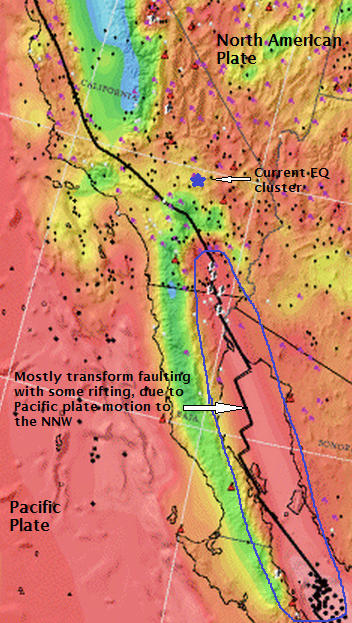
In the map above, the area south of the cluster on the southern extent of the SAF is bright red because the crust is thin there, allowing the hot mantle to heat the crust. There are pockets of magma below the Salton Buttes, but it fairly deep.
These quakes are shallow, but so were the Landers and Hector Mine earthquakes and their aftershocks.
As you proposed here, this current activity could be volcanically related, but I see the data pointing toward a tectonic origin.
Since the activity seems to have died down (see nearest seismometer CI.HEC.BHZ), all of this is probably moot.
Dianec
How I understand it - these sorts of faults are unlikely to have catastrophic earthquakes mainly because even bigger ones aren't as likely to be as destructive as they would be on another type of fault. That doesn't mean they aren't a concern. For example, it can place pressure in its neighbor San Andreas.
This cluster of earthquakes is happening on the same type of fault as the San Andreas; a transform fault. Researchers believe these faults that are sub-parallel to the San Andreas are accommodating a small percentage of the strain building on the SAF due to the continuous plate motion of the Pacific trying to slide NNW past the NA plate.
Your right, they aren't likely to be highly destructive, but that is because the population in the area is low. They can effect infrastructure, such as the railway nearby as Gigman pointed out on the previous page. Plus, the known* fault planes involved in the area are too small to produce quakes much larger than the Landers mag 7.3.
*There is a large amount of sediment in the area, which can hide faults.
Dianec
I don't know if they are also seeing deformation at Joshua Tree (currently) but that could mean magma movement or it could mean more creeping (most likely the later). Regardless - as it rips apart magma will move up. Same for mammoth mountain and the rest of them. I am not reading that harmonic tremors are present yet am reading of possible magma intrusion. That tells me it is a result of the tearing - very deep down there is some pressure from magma (maybe).
I looked at the GPS in the region yesterday, but didn't see any abnormal movements.
Yes, there are holocene volcanic fields about 20 kms west of the current cluster. Lavic Lake
(zoom out a click to see the current eq cluster in relation to the volcanic area. Scroll down to find a good visual of the quake depths over time.)
But when you look at the style of faulting of the largest quake in this sequence(mag 4.3 on Saturday), it shows strike-slip motion.
Usually, a vertical intrusion of molten magma exhibits normal-style fault mechanisms.
If we look at the thermal anomaly map of the region, the crust around the quake cluster (purple star) is relatively cool, compared with neighboring areas.

In the map above, the area south of the cluster on the southern extent of the SAF is bright red because the crust is thin there, allowing the hot mantle to heat the crust. There are pockets of magma below the Salton Buttes, but it fairly deep.
These quakes are shallow, but so were the Landers and Hector Mine earthquakes and their aftershocks.
As you proposed here, this current activity could be volcanically related, but I see the data pointing toward a tectonic origin.
Since the activity seems to have died down (see nearest seismometer CI.HEC.BHZ), all of this is probably moot.
edit on 10/7/2013 by Olivine because: (no reason given)
edit on 10/7/2013 by Olivine because: just removing my head from a
dark place
reply to post by Olivine
I appreciate your straightening that out for me - it can get confussing. I did read however that there are other faults in this area. Maybe they are connected somehow but not under this area. I guess the main one, the San Andreas is the one that we always need to worry about. If these are happening on that fault directly it's always concerning - so good to see it has quieted down again.
I don't know why but I have been more concerned about volcanic activity the last several months. I think it was the rotten egg smell and steam coming off a lake near Lakeview Oregon in April that started this (way far north of area we are talking about). I know that can be common for this area but having driven by it so much without these signs made if a first for me - and therefore caught my attention. The entire area - from the Mexico border to Canada is one big line of volcanoes - whole western US actually. I think that is what I'm always trying to connect - how these (quakes) can impact those (volcanoes). When will it be too big of a quake to contain the magma?
Anyway - thank you for taking the time to educate me. I know it's not something most want to be doing with their time so it's appreciated.
Thebel
Tjörnes Fracture Zone in Iceland is getting calm, very few earthquakes happen. Is it over? Its almost like tremor in this:
Looks like it is tapering off.
I just loaded September and part October Iceland data on to my Iceland page, although its not specifically focused on the Tjörnes fracture zone you can zoom the map into that area for each month. The graphs show the activity increase and decrease quite clearly which would be this swarm off Eyjafjörður. Did this start around the 25th September?
Interesting the gaps in activity, I'd have to break the data down to lat/long to see if they are all from this swarm.
Not as big a swarm as NE of Grimsey back in April.
Always lots happening in Iceland though when you take the magnitude down to M-1.0
(which is 0.00000048TTNT of energy, which is just under half a gram of TNT or when converted to Calories equals the energy of 2 Chocolate Chip cookies)
edit on 10u27927913 by muzzy because: (no reason given)
interesting quote from that last link
If you want to destroy a car, you can do it with TNT. But more energy could be obtained by feeding an equal weight of chocolate chip cookies to a group of people and giving them sledgehammers.
edit on 10u27927913 by muzzy because: (no reason given)
while I was waiting for the sun to come up, i broke the data down to the swarm in question
Lat 66.15 to 66.4, Long-18 to -19
mag
Referencing a conversation a page or three ago regarding Wadati-Benoiff zones, in a
post I recently made in the
Research Forum, I have found much of interest.
Rather than subduction,
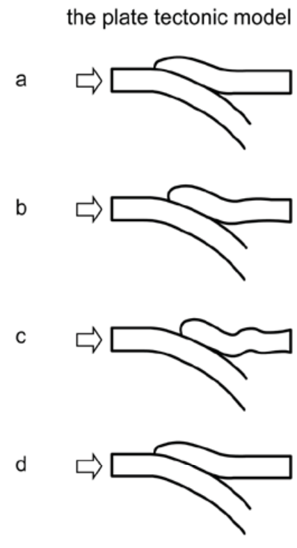
what is happening is extrusion:
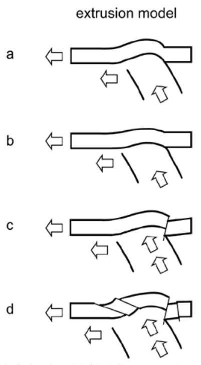
Geodynamics of the Wadati-Benioff zone earthquakes: The 2004 Sumatra earthquake and other great earthquakes
There is also evidence of uplift in two other subduction events:
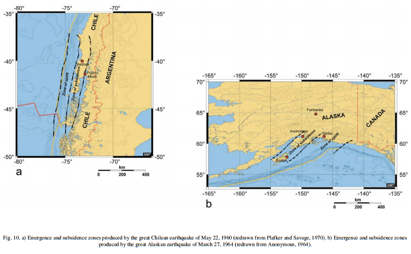
What is going on in these cases that are supposed to be sub-ducting plates generating an increase in distance from center?
Due to the limitations of conversation within the Research forum, I wanted to bring this information and topic to a wider audience and feel that it goes toward the spirit of Quake Watch to include herein and with all of the quaketards here, I'd love to have y'alls thoughts on these data.
Rather than subduction,

what is happening is extrusion:

Geodynamics of the Wadati-Benioff zone earthquakes: The 2004 Sumatra earthquake and other great earthquakes
There is also evidence of uplift in two other subduction events:
Chile
A large seismic event struck the Chilean coast at 19.10:40 UT on May 22, 1960 (Plafker and Savage, 1970; Cifuentes, 1989; Cifuentes and Silver, 1989). The hypocenter was at 38.05°S – 72.34°W and the focal depth was estimated around 35 km, similar to the Sumatra earthquake. A recent relocation (Krawczyk and the SPOC Team, 2003) provides a more western and slightly deeper hypocenter > 73° 05’ W, 38° 15’ S, H = 38.5 km).
…
The records suggest that a large slow and silent foreshock took place on the deepest portion of the fault 15 minutes before the main shock, with a seismic moment comparable to that of the main event (Plafker and Savage, 1970; Kanamori and Cipar, 1974; Lund, 1982; Cifuentes, 1989; Cifuentes and Silver, 1989).
…
In this case, the rupture would have to nucleate in the subcrustal ductile lithosphere where the stress produced by the subducting slab would dissipate.
…
Alaska
In the late afternoon of March 27, 1964, the second largest earthquake (but eventually the largest on recent reassessment of magnitude by Okal – seminar at INGV headquarters) ever experienced by mankind struck the gulf of Alaska, with epicentre (61.0°N, 147.7°W) about 150 km east of Anchorage, near College Fiord (Anonymous, 1964). In the map attached to the first available report (Anonymous, 1964) a delineation of the uplifted and subsided zones is drawn (Figure 10b).
As in the Sumatra earthquake, in the Alaska seismic event a long belt – at least 500 km – of subsided crust followed an inner zone from near Anchorage to Kenai Peninsula and Kodiak Island. A subsidence of up to 2.0 m was recorded. An emergence zone with a peak uplift of 8 m was recognized in the external region facing the Pacific. It was probably of the same length as the subsided one.

What is going on in these cases that are supposed to be sub-ducting plates generating an increase in distance from center?
Due to the limitations of conversation within the Research forum, I wanted to bring this information and topic to a wider audience and feel that it goes toward the spirit of Quake Watch to include herein and with all of the quaketards here, I'd love to have y'alls thoughts on these data.
reply to post by ericblair4891
"Earth's core is rich in iridium",,,are u suggesting that this vent, directly, connects/opens too the Earths Core?
"Earth's core is rich in iridium",,,are u suggesting that this vent, directly, connects/opens too the Earths Core?
reply to post by jadedANDcynical
winters comming,,old house old windows,,,so i use a caulking compound,, too re-seal , any, cracks,holes,etc,,
if molten lava was caulk under pressure, and hard as i might, occasionally, the old crust, where it supported, ,breaks,,cracks,, but eventually the caulk hardens,,etc,,,
what is happening is extrusion,,,,,,,like a caulking gun,,only with lava,,,so yes i like "extrusion"
new topics
-
Judge rules president-elect Donald Trump must be sentenced in 'hush money' trial
US Political Madness: 25 minutes ago -
Farmers wife
Music: 1 hours ago -
NJ Drones tied to Tesla explosion at Trump Las vegas
General Conspiracies: 3 hours ago -
New Jersey-Teachers Can Now Be Certified Without Passing Basic Reading Writing Math Testing
Education and Media: 6 hours ago -
Matthew Livelsberger said he was being followed by FBI
Political Conspiracies: 9 hours ago -
How the Sikhs Deal with Muslim Grooming Gangs – Tommy Robinson
Social Issues and Civil Unrest: 10 hours ago -
Paranoid Liberals Believe U.S. Service Members are More Dangerous than Illegal Aliens.
Social Issues and Civil Unrest: 11 hours ago
top topics
-
Matthew Livelsberger said he was being followed by FBI
Political Conspiracies: 9 hours ago, 16 flags -
Here we again... CHINA having mass outbreak of something
Diseases and Pandemics: 12 hours ago, 8 flags -
The 119th Congress has Officially Opened for Business
Mainstream News: 12 hours ago, 7 flags -
Paranoid Liberals Believe U.S. Service Members are More Dangerous than Illegal Aliens.
Social Issues and Civil Unrest: 11 hours ago, 6 flags -
How the Sikhs Deal with Muslim Grooming Gangs – Tommy Robinson
Social Issues and Civil Unrest: 10 hours ago, 6 flags -
New Jersey-Teachers Can Now Be Certified Without Passing Basic Reading Writing Math Testing
Education and Media: 6 hours ago, 6 flags -
NJ Drones tied to Tesla explosion at Trump Las vegas
General Conspiracies: 3 hours ago, 3 flags -
Flee from idolatry
Religion, Faith, And Theology: 17 hours ago, 3 flags -
Farmers wife
Music: 1 hours ago, 0 flags -
Judge rules president-elect Donald Trump must be sentenced in 'hush money' trial
US Political Madness: 25 minutes ago, 0 flags
active topics
-
Paranoid Liberals Believe U.S. Service Members are More Dangerous than Illegal Aliens.
Social Issues and Civil Unrest • 30 • : hangedman13 -
Matthew Livelsberger said he was being followed by FBI
Political Conspiracies • 62 • : WeMustCare -
Candidate TRUMP Now Has Crazy Judge JUAN MERCHAN After Him - The Stormy Daniels Hush-Money Case.
Political Conspiracies • 2172 • : WeMustCare -
Tesla Cybertruck Explodes in Front of Trump Hotel in Las Vegas
Mainstream News • 195 • : KrustyKrab -
Musk calls on King Charles III to dissolve Parliament over Oldham sex grooming gangs
Mainstream News • 88 • : WeMustCare -
Judge rules president-elect Donald Trump must be sentenced in 'hush money' trial
US Political Madness • 0 • : JadedGhost -
-@TH3WH17ERABB17- -Q- ---TIME TO SHOW THE WORLD--- -Part- --44--
Dissecting Disinformation • 3923 • : RelSciHistItSufi -
Watts home paranormal activity
Paranormal Studies • 6 • : TowmasterLG -
Congress Says the FBI is Covering Up Vital Info on the Jan 5th 2021 D.C. Pipe Bombs at RNC-DNC.
Political Conspiracies • 28 • : GotterDameron23 -
New Jersey-Teachers Can Now Be Certified Without Passing Basic Reading Writing Math Testing
Education and Media • 9 • : rickymouse

