It looks like you're using an Ad Blocker.
Please white-list or disable AboveTopSecret.com in your ad-blocking tool.
Thank you.
Some features of ATS will be disabled while you continue to use an ad-blocker.
share:
reply to post by Nyiah
Oops apologies. Never saw your post until after I had posted, but perhaps mine answers your question?
Oops apologies. Never saw your post until after I had posted, but perhaps mine answers your question?
Originally posted by PuterMan
reply to post by Nyiah
Oops apologies. Never saw your post until after I had posted, but perhaps mine answers your question?
You certainly did, and also about the UK's EQ history Infrequent as they are, they do have some occasional doozies, it seems.
All of this shifting pressure from the recent series of ridge quakes has to translate around somewhere. As quiet as it's been elsewhere, I'm beginning to wonder if the Virgin Islands swarm might be a hint. Perhaps that plate might rattle soon?
Yesterday I updated a page on eqarchives
NZ Mag5+
Only done 2000-2013 so far.
With the data I get this graph
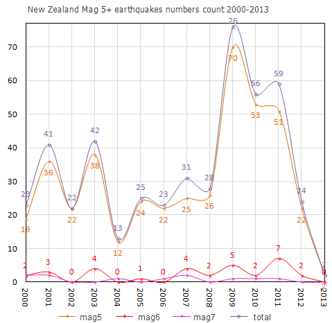
of course if I had used my 37 mag5+ quakes for 2012 that I saved as they happened, and not the "reviewed" data the sudden drop in 2012 wouldn't have been so dramatic.
At 7.8 that 2009 Dusky Sound quake put out a LOT of aftershocks.
NZ Mag5+
Only done 2000-2013 so far.
With the data I get this graph

of course if I had used my 37 mag5+ quakes for 2012 that I saved as they happened, and not the "reviewed" data the sudden drop in 2012 wouldn't have been so dramatic.
At 7.8 that 2009 Dusky Sound quake put out a LOT of aftershocks.
I would say the next 3 days will give us quite a few 5+ ones... let's see if I am right
reply to post by aLLeKs
didn't take long ALLeks
I seen it first on LISS SNZO, then looked at GFZ and they had 5.9
USGS are 5.9mb too
bet LDEO have 6.0
just noticed USGS have given my 5.2ML quake on Sunday NZST a 4.9mb
says " Generated 2013 JAN 20 at 00:59 UTC" on the phase data page, but I didn't see it when I looked on Sunday..
looks like ass-covering to me.
No local stations were used
didn't take long ALLeks
Northern Sumatera, Indonesia
date= 21-Jan-2013 22:22:51.0
lat= 4.97 lon= 95.8
depth= 15km
Ms: 6.1/27stations, mb: 6.0/22stations
RAS
I seen it first on LISS SNZO, then looked at GFZ and they had 5.9
USGS are 5.9mb too
bet LDEO have 6.0
edit on 21-1-2013 by muzzy because: (no reason given)
just noticed USGS have given my 5.2ML quake on Sunday NZST a 4.9mb
says " Generated 2013 JAN 20 at 00:59 UTC" on the phase data page, but I didn't see it when I looked on Sunday..
looks like ass-covering to me.
No local stations were used
edit on 21-1-2013 by muzzy because: (no reason given)
This quake in Sumatra
Location in Google Maps
Derived from Event Data Source: USGS
Powered by QVSData
will be mag 6 eventually
It has 2 x M6+ tensor solutions and EMSC have it at 6.1 Mw
Magnitude 5.9 - Northern Sumatra. Indonesia
Location in Google Maps
- Date-Time: Monday, January 21, 2013 @ 22:22:54 UTC
- Earthquake location: 4.961°N, 96.083°E,
- Earthquake depth: 16.6 km
- Distances:
35km (21mi) SW of Reuleuet, Indonesia
48km (29mi) SSE of Sigli, Indonesia
73km (45mi) WSW of Bireun, Indonesia
91km (56mi) N of Meulaboh, Indonesia
653km (405mi) WNW of Kuala Lumpur, Malaysia
- Event ID: usb000esgn
Derived from Event Data Source: USGS
Powered by QVSData
will be mag 6 eventually
It has 2 x M6+ tensor solutions and EMSC have it at 6.1 Mw
edit on 21/1/2013 by PuterMan because: (no reason given)
reply to post by muzzy
You posted while I was pereparing that.
USGS have 5.9 Mwb which is moment calculated on the body wave as opposed to Mwp, moment calculated on the P wave and various other combinations of nonsense.
The normal body wave tensor is 6.0 and the 'regional' tensor is 6.1.
WTH is the 'regional tensor'? Another think to confuse the public perhaps. The USGS seems to make a science of being obtuse as possible.
ETA: Mwr - Moment regional.
edit on 21/1/2013 by PuterMan because: (no reason given)
reply to post by PuterMan
Just happened by at lunch time
Unusual that its on land.
I deleted the BMGK or whatever it was called Indonesian Quakes site from my Speed Dial, last time I used it last week it threw me a Trojan, my anti-virus popped up and told me to "get the heck out of here", so I did.
So be careful if you go there to check this quake out.
edit on 21-1-2013 by muzzy because: (no reason given)
reply to post by muzzy
The 5.8 in the South Atlantic has me really interested. I lived in Recife, PE, Brasil for years, and still have family there. In fact, they just emailed me about it which is why I am posting. They live on the 12th floor of a building and felt it swaying. USGS doesnt list anything historical.
They wondered if this had anything to do with the offshore oil drilling that is going on.
What fault would this be? Thanks in advance.
Peace
earthquake.usgs.gov...
edit on 21-1-2013 by lasertaglover because: Added link
reply to post by lasertaglover
Wow, I did a triple-take at that location. I can't ever recall anything so close to the Brasilian coast in the Atlantic. I keep going back to the map in disbelief. I don't understand why it isn't on the real-time map, maybe I need to refresh the page in case there's an error...
Wow, I did a triple-take at that location. I can't ever recall anything so close to the Brasilian coast in the Atlantic. I keep going back to the map in disbelief. I don't understand why it isn't on the real-time map, maybe I need to refresh the page in case there's an error...
This is going to be an interesting year indeed. Lets keep on the watch OP.
reply to post by Nyiah
Only place still even listing the quake is the old eq map on usgs twitter made mention of the 5.8 brazil extinction protocal has it on there blog site. But anywhere else I look this quake is a ghost not showing up anywhere yet reports on twitter claiming shaking.... Any reason usgs wouldn't still hours later have the quake listed did it happen?? whats the deal usually a few minutes behind real time monitoring but hours later with no confirm I dunno location weird, aftermath weird, lack of info weird just plain weird.
SaneThinking
quakes.globalincidentmap.com...
Couldn't sleep. Found it at this link. Although this isn't the best place. But it was there.
Couldn't sleep. Found it at this link. Although this isn't the best place. But it was there.
reply to post by Nyiah
It was there last night because I saw it just after 2300 UTC when I looked - in fact it still has not been deleted from the 7 day listing. It has however been deleted from the USGS interactive.
Note that EMSC and GFZ do not have this event either.
There is no event showing on the nearest seismo for that date & time.
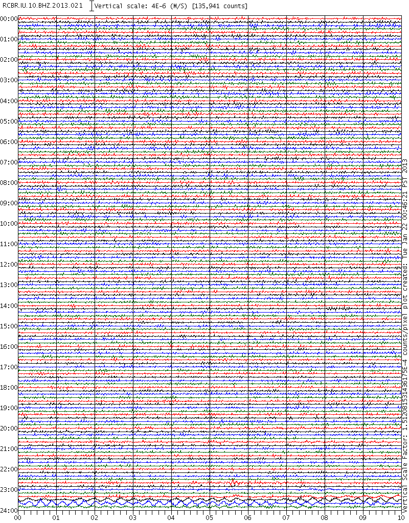
The event IS still showing in Google Earth as well and still shows on the old style web page and there is phase data at the time of posting.
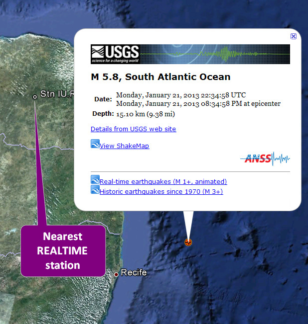
It was there last night because I saw it just after 2300 UTC when I looked - in fact it still has not been deleted from the 7 day listing. It has however been deleted from the USGS interactive.
Note that EMSC and GFZ do not have this event either.
There is no event showing on the nearest seismo for that date & time.

The event IS still showing in Google Earth as well and still shows on the old style web page and there is phase data at the time of posting.

reply to post by lasertaglover
No disrespect to your family, but are they sure it was this 'event' that caused the building to sway? This was first posted as a 5.8mb which is more than a Mag 6 Mw so there is absolutely no way this would not be showing on that seismogram.
Is there wind in the area or anything else that could affect the building?
I can see the Sumatra event going through on the seismos all over South American and in my opinion the promulgated 5.8 that has been deleted was a false trigger from Sumatra.
If shaking was felt it was not from that event and the time of the shaking is critical to giving a clue as to what may have caused it. My guess is that it was something local. One would need to analyse the twitter responses to see how wide spread the shaking appeared to be.
EMSC had for some hours during the night, sourced from the deleted USGS event
URL was
M 5.8 - SOUTH ATLANTIC OCEAN - 2013-01-21 22:34:58 UTC
www.emsc-csem.org/Earthquake/earthquake.php?id=301734
The error also generated an automatic CPP (rCMT USGS research CMT) moment tensor of Mw 6.0, EMSC removed it too.
Hidden, accessible for an unknown time at EMSC and USGS
usr/passwd : rcmt/rcmt
neic.cr.usgs.gov/beta/rcmt/events/130121223458.B000ESH7
www.emsc-csem.org/Earthquake/mtfull.php?id=301734
reply to post by PuterMan
They have lived there since I moved back to the states in 92 and have experienced high wind before. I've been back many times and always stayed with them and have never felt their building shaking, even through some bad storms. Their building is right on the beach on Boa Viagem.
I'll check with them again today. I'm curious as to why their email last night immediately mentioned the oil drilling there. Why they thought of that connection.
Peace
edit on 22-1-2013 by lasertaglover because: (no reason given)
reply to post by lasertaglover
The time is the critical thing. It looks as if there was an event but difficult to say if it was the one. It appears to be about 23:03 UTC at the seismo. If the event was indeed where located, but not the magnitude then it would have been about 300 km from the seismo and it does seem to be the case on the VHZ channel which is good for showing these things.

It was definitely an event but I am guessing around Mag 4.5 from the seismo although it is very difficult to tell.
OK, rethink. I have downloaded the whole day for the VHZ channel and that event actually looks as if it starts @2hrs 16.5 minutes after the day start BUT the lowest I can get to is 1 Hz and the VHZ channel is 0.1 Hz so the actual time is 22.75 hours or 22:45
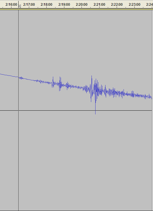
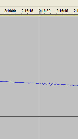
The ghost event was 22:34 and this one definitely does NOT start before 22:45 so is NOT the ghost event but is a local distant event to the seismo.
The time is the critical thing. It looks as if there was an event but difficult to say if it was the one. It appears to be about 23:03 UTC at the seismo. If the event was indeed where located, but not the magnitude then it would have been about 300 km from the seismo and it does seem to be the case on the VHZ channel which is good for showing these things.

It was definitely an event but I am guessing around Mag 4.5 from the seismo although it is very difficult to tell.
OK, rethink. I have downloaded the whole day for the VHZ channel and that event actually looks as if it starts @2hrs 16.5 minutes after the day start BUT the lowest I can get to is 1 Hz and the VHZ channel is 0.1 Hz so the actual time is 22.75 hours or 22:45


The ghost event was 22:34 and this one definitely does NOT start before 22:45 so is NOT the ghost event but is a local distant event to the seismo.
edit on 22/1/2013 by PuterMan because: (no reason given)
edit on 22/1/2013 by PuterMan because: (no reason given)
reply to post by PuterMan
Thank you. I have not heard back from them yet this morning. I did send an email to another friend of mine in who lives in Olinda, right next to Recife, but she did not feel anything. She lives on a pretty large hill for the area, so I dont know if that affects anything. Also heard back from my cousin in Fortaleza to the north, and he felt nothing too.
I know my aunt is uber worried about the offshore drilling. Several years ago they found oil larger than the Saudi fields off the coast and are living through an oil rush there. I was last there in 2011, & was shocked by the economical growth in the region.
So I'm still curious if the oil had anything to do with it. My home country is kinda infamous for faulty equipment, could the seismos be possibly wrong?
Thanks again.
Peace
update to post by PuterMan
I just wanted to clarify that the wave, if we use 8 km/second, over the 300 km distance would take 37.5 seconds, thus if it appears on the seismo @22:45 the event took place less than a minute before that and could not be the one at 22:34.
Unfortunately the latest quake in Brazil seems to be 23rd December 2012! www.obsis.unb.br...
Now I had not considered the length of the event. If the gap below is the difference between the P and S then the event was about 1120 km away (@5km/sec difference P/S)
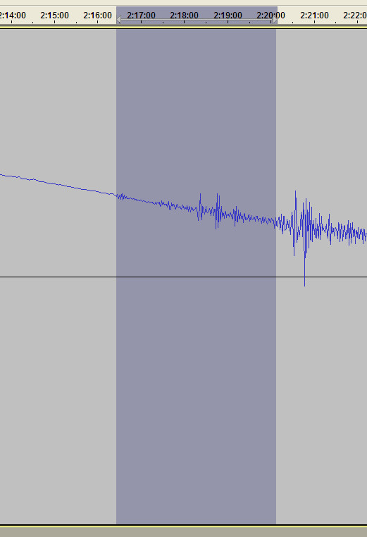
If however the larger part is the surface wave which is more likely then one of the two smaller 'blips' in between is the S wave. This would make it about half that.
The full distance is very close to the M5 on the Central Mid Atlantic Ridge on the 18th - which makes sense.
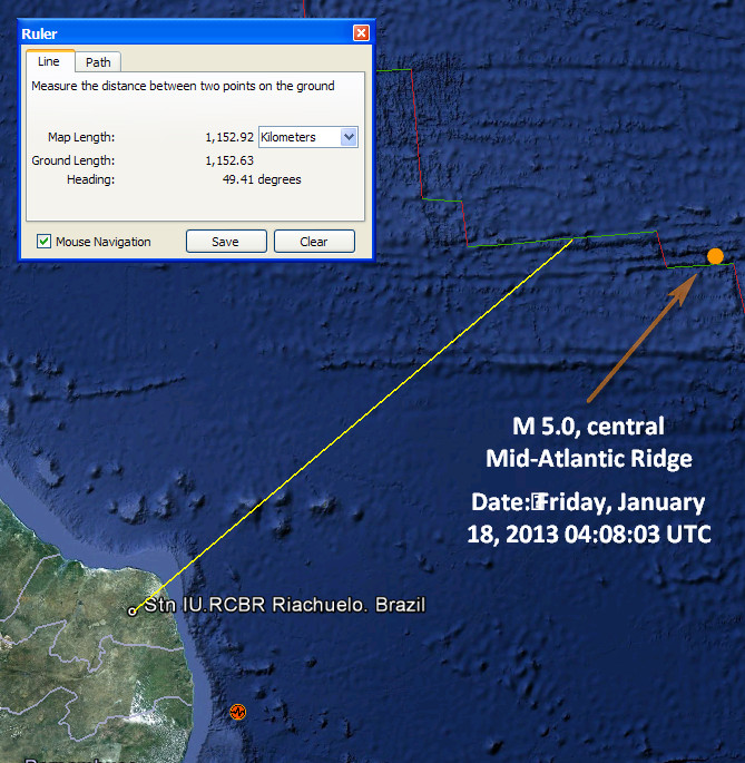
Other than that I really don't know but this IS a teleseismic event and at fact value is either closer than the 5.0 on the 18th or bigger than it. I certainly is not what swayed the tower block.
I just wanted to clarify that the wave, if we use 8 km/second, over the 300 km distance would take 37.5 seconds, thus if it appears on the seismo @22:45 the event took place less than a minute before that and could not be the one at 22:34.
Unfortunately the latest quake in Brazil seems to be 23rd December 2012! www.obsis.unb.br...
Now I had not considered the length of the event. If the gap below is the difference between the P and S then the event was about 1120 km away (@5km/sec difference P/S)

If however the larger part is the surface wave which is more likely then one of the two smaller 'blips' in between is the S wave. This would make it about half that.
The full distance is very close to the M5 on the Central Mid Atlantic Ridge on the 18th - which makes sense.

Other than that I really don't know but this IS a teleseismic event and at fact value is either closer than the 5.0 on the 18th or bigger than it. I certainly is not what swayed the tower block.
new topics
-
To become president, Zelensky had to learn Ukrainian
Political Conspiracies: 5 hours ago -
Green Grapes
General Chit Chat: 9 hours ago
top topics
-
S.C. Jack Smith's Final Report Says Trump Leads a Major Conspiratorial Criminal Organization!.
Political Conspiracies: 16 hours ago, 11 flags -
Advice for any young Adult .
General Chit Chat: 17 hours ago, 10 flags -
Green Grapes
General Chit Chat: 9 hours ago, 6 flags -
To become president, Zelensky had to learn Ukrainian
Political Conspiracies: 5 hours ago, 5 flags -
Those Great Fresh Pet Commercials
Television: 14 hours ago, 3 flags
active topics
-
Trump says ownership of Greenland 'is an absolute necessity'
Other Current Events • 66 • : bastion -
To become president, Zelensky had to learn Ukrainian
Political Conspiracies • 5 • : Dalamax -
Los Angeles brush fires latest: 2 blazes threaten structures, prompt evacuations
Mainstream News • 120 • : Lazy88 -
Gravitic Propulsion--What IF the US and China Really Have it?
General Conspiracies • 37 • : Lazy88 -
The Truth about Migrant Crime in Britain.
Social Issues and Civil Unrest • 34 • : angelchemuel -
Russia Ukraine Update Thread - part 3
World War Three • 6905 • : Arbitrageur -
Planned Civil War In Britain May Be Triggered Soon
Social Issues and Civil Unrest • 22 • : Freeborn -
Labour Plotting to Postpone May's Council Elections ?
Regional Politics • 21 • : angelchemuel -
What Comes After January 20th
Mainstream News • 34 • : charlest2 -
Some sausage, some chicken, some sauce, some onions and some garlic...and some peppers!
Food and Cooking • 4 • : putnam6
