It looks like you're using an Ad Blocker.
Please white-list or disable AboveTopSecret.com in your ad-blocking tool.
Thank you.
Some features of ATS will be disabled while you continue to use an ad-blocker.

WTC destruction, the Leftover candidates, Pro&Contra Arguments.
page: 18share:
reply to post by LaBTop
It opened mine regarding Dr. Greg Jenkins. When she realized she was set up she walked out.
The Dr. Greg Jenkings interview opened my eyes wide open, regarding Mrs Wood.
It opened mine regarding Dr. Greg Jenkins. When she realized she was set up she walked out.
reply to post by LaBTop
It will bring me the wisdom of an index of the energy of the shaking earth that is called the Richter (logarithmic, not exponential) scale of a final value of 2.3 from only a surface wave that is the standard to use against other events like the Kingdome demolition which produced a 2.3 earthquake.
Well, we also have a PAIR of waves, even a triple pair...
The WTC 1,2 and 7 seismogram from the first week after 9/11.
Just overlap them two Twin tower seismic collapse graphs, and see what wisdom that cross correlation technique will bring you.
It will bring me the wisdom of an index of the energy of the shaking earth that is called the Richter (logarithmic, not exponential) scale of a final value of 2.3 from only a surface wave that is the standard to use against other events like the Kingdome demolition which produced a 2.3 earthquake.
edit on 25-12-2013 by leostokes because: spelling
reply to post by LaBTop
Would you please do it for me? Just circle the 3 pairs.
Well, we also have a PAIR of waves, even a triple pair...
The WTC 1,2 and 7 seismogram from the first week after 9/11.
Just overlap them two Twin tower seismic collapse graphs, and see what wisdom that cross correlation technique will bring you.
Would you please do it for me? Just circle the 3 pairs.
reply to post by LaBTop
The seismic signal from WTC 7 was so small it was below the noise level. They found it by knowing its arrival time.
Thus you can work back on your 9/11 seismogram now, with cross correlation, to the arrival times of any predicted P-wave, S-wave and the Lg-wave.
The seismic signal from WTC 7 was so small it was below the noise level. They found it by knowing its arrival time.
Architects and Engineers for 9/11 Truth debunk Judy Wood
911debunkers.blogspot.com.au...
They seem to be angry at her....
www.journalof911studies.com...
Page 4 of 18, a much better detailed picture of that parking lot at the top left of that cluster of 4 pictures. You can see the fireman using the foam of his fire extinguisher to stop the hood fire. Hood is white now from his foam.
I hereby retract my remark about tow trucks present in that emergency parking lot.
I thought the two cars where the fire extinguisher man is standing in between, under that smoke cloud, were both tow trucks. This photo is much better detailed than the Wood website one. You still have to enlarge this pdf-page 4, to 400%, to see those two cars really clear.
Then you also see the red fires and all the paper sheets on the ground. Quite normal explanation for the fires. Burning debris, burning paper under cars, leaked petrol under cars, burning debris fallen in already shattered roofs of cars towed there, etc.
Nice heap of high debris piles of both Twin towers photos in those last 4 minutes of that Greg Jenkings interview with Mrs Wood.
reply to post by LaBTop
Thanks for your reply. Nonetheless, the reason for the lot may very well be for temporary storage of cars that needed to be moved to make way for the rescuers. The tow trucks may have been out of sight when the afternoon arial photo was taken.
Thanks for your reply. Nonetheless, the reason for the lot may very well be for temporary storage of cars that needed to be moved to make way for the rescuers. The tow trucks may have been out of sight when the afternoon arial photo was taken.
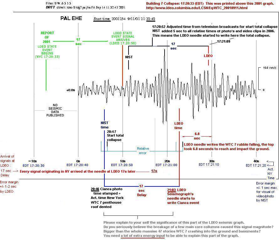
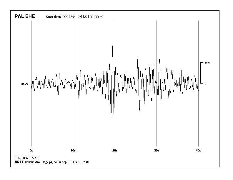
All 5 Professional seismograms registered by LDEO/Columbia.edu by their PAL EHE seismometer at their seismic station at Palisades, N.Y.State :
www.ldeo.columbia.edu...
Have a good look at the WTC 7 collapse seismogram (which is not altered since 9/12/2001, which let me think that the scientists at LDEO are genuine) :
www.ldeo.columbia.edu...
First, note that the "Start times" printed IN all 5 seismograms do not match the "Collapse times" printed ABOVE them...!
Especially the WTC 7 one DIFFERS a full SEVEN seconds :
"Building 7 Collapse: 21:20:33 (UTC), 17:20:33 (EDT) " above it.
"Start time 21:20:40" in it. A whopping seven seconds difference....
For obvious reasons, to let the graph fit in the same 40 secs space as all other graphs were compacted in.
Which is in fact in our interest since the propagation time of seismic signals through the N.Y.State upper crust from WTC Manhattan to Palisades seismic station is 17 seconds. (see it as 7 + 10)
So, the arrival of the FIRST collapse signals ON THAT GRAPH is at the seven to zero and then another ten secs, to the TEN secs position.
All of that, ACCORDING to LDEO...! ( -7 secs + 10 secs = 17 secs)
THAT looks exactly right, AIN'T IT SO...?
Well, IT IS NOT...
According to the, by NIST themselves, atomic clocked time-stamped photograph of a Mr Nicolas Cianca in their archives.
Who took a photo of the first sinking moment of the roof of the eastern penthouse of the WTC 7, into the roof of WTC 7, which NIST themselves declared the first sign of the BEGINNING of the total collapse of WTC 7.
This is a video with the low frequency explosion sound 3 secs before you see that penthouse tumble down into the roof space :
It took another 8.3 seconds to let both penthouses first totally sink beyond the roof rim, before the real total collapse of the WHOLE building, that famous SINKING of all four facades including the roof rim, started.
The Cianca photo is STILL to this late 2013 day, atomic clock-timestamped by NIST as 5:20:46 p.m. (EDT), which is 21:20:46 UTC :
files.abovetopsecret.com...
Now, add 17 secs to the NIST-Cianca timestamp moment on that WTC 7 LDEO collapse graph.
The start time of that UTC graph is 21:20:40 UTC which is 5:20:40 p.m. (EDT), the Cianca photo was thus shot near WTC 7 in Manhattan-NY at the 6 secs position in that seismogram. Now add 17 seconds arrival timespan for the seismic signal accompanied by that photo, and you arrive on that graph at the 23 secs position, which is at least 3 secs after that first huge amplitude peak pack died down.
Now what was that?
A seismic signal with alot bigger amplitude than whatever registered later on during the global collapse of a 47 stories high steel/concrete building.
And that would be of no importance, when it would have been peaks with a lot less amplitude (smaller peaks), indicating a relatively small energetic event took place, to get that eastern penthouse sinking into the 47th floor its roof rim.
BUT, in reality, that energetic event showed FAR TOO BIG amplitudes.
Which can only mean one thing, they blew the hell out of about 10 floors worth of core columns, from floor 5 to 10. That created hollow center space, where the above floors started to topple in to, sucking the east penthouse down into the interior, as the resulting first visible sign of that TB explosion.
Use: CTRL+ ,in your browser, to enlarge my drawing greatly :

Partially burned at a few lower floors, all office spaces burned at each floor, each no longer than 30 minutes, while the fires jumped from room to room.
By far not enough to get steel columns weakened or melted. After cooling down after been exposed to fire for no more than 30 mins, those minimally heated columns were as strong as ever. Steel disperses heat greatly, up and down such columns. Thus lowering the overall heat per height.
The NIST last straw reasoning, that crazy heat expansion of trusses or beams theory, is dealt with by just introducing normal heat dispersion to their poisoning of the well. And in reality, different truss seats than they came up with.
BIG EVIDENCE POST.
Compare these two YT videos
www.ldeo.columbia.edu...
Have a good look at the WTC 7 collapse seismogram (which is not altered since 9/12/2001, which let me think that the scientists at LDEO are genuine) :
www.ldeo.columbia.edu...
First, note that the "Start times" printed IN all 5 seismograms do not match the "Collapse times" printed ABOVE them...!
Especially the WTC 7 one DIFFERS a full SEVEN seconds :
"Building 7 Collapse: 21:20:33 (UTC), 17:20:33 (EDT) " above it.
"Start time 21:20:40" in it. A whopping seven seconds difference....
For obvious reasons, to let the graph fit in the same 40 secs space as all other graphs were compacted in.
Which is in fact in our interest since the propagation time of seismic signals through the N.Y.State upper crust from WTC Manhattan to Palisades seismic station is 17 seconds. (see it as 7 + 10)
So, the arrival of the FIRST collapse signals ON THAT GRAPH is at the seven to zero and then another ten secs, to the TEN secs position.
All of that, ACCORDING to LDEO...! ( -7 secs + 10 secs = 17 secs)
THAT looks exactly right, AIN'T IT SO...?
Well, IT IS NOT...
According to the, by NIST themselves, atomic clocked time-stamped photograph of a Mr Nicolas Cianca in their archives.
Who took a photo of the first sinking moment of the roof of the eastern penthouse of the WTC 7, into the roof of WTC 7, which NIST themselves declared the first sign of the BEGINNING of the total collapse of WTC 7.
This is a video with the low frequency explosion sound 3 secs before you see that penthouse tumble down into the roof space :
It took another 8.3 seconds to let both penthouses first totally sink beyond the roof rim, before the real total collapse of the WHOLE building, that famous SINKING of all four facades including the roof rim, started.
The Cianca photo is STILL to this late 2013 day, atomic clock-timestamped by NIST as 5:20:46 p.m. (EDT), which is 21:20:46 UTC :
files.abovetopsecret.com...
Now, add 17 secs to the NIST-Cianca timestamp moment on that WTC 7 LDEO collapse graph.
The start time of that UTC graph is 21:20:40 UTC which is 5:20:40 p.m. (EDT), the Cianca photo was thus shot near WTC 7 in Manhattan-NY at the 6 secs position in that seismogram. Now add 17 seconds arrival timespan for the seismic signal accompanied by that photo, and you arrive on that graph at the 23 secs position, which is at least 3 secs after that first huge amplitude peak pack died down.
Now what was that?
A seismic signal with alot bigger amplitude than whatever registered later on during the global collapse of a 47 stories high steel/concrete building.
And that would be of no importance, when it would have been peaks with a lot less amplitude (smaller peaks), indicating a relatively small energetic event took place, to get that eastern penthouse sinking into the 47th floor its roof rim.
BUT, in reality, that energetic event showed FAR TOO BIG amplitudes.
Which can only mean one thing, they blew the hell out of about 10 floors worth of core columns, from floor 5 to 10. That created hollow center space, where the above floors started to topple in to, sucking the east penthouse down into the interior, as the resulting first visible sign of that TB explosion.
Use: CTRL+ ,in your browser, to enlarge my drawing greatly :
Partially burned at a few lower floors, all office spaces burned at each floor, each no longer than 30 minutes, while the fires jumped from room to room.
By far not enough to get steel columns weakened or melted. After cooling down after been exposed to fire for no more than 30 mins, those minimally heated columns were as strong as ever. Steel disperses heat greatly, up and down such columns. Thus lowering the overall heat per height.
The NIST last straw reasoning, that crazy heat expansion of trusses or beams theory, is dealt with by just introducing normal heat dispersion to their poisoning of the well. And in reality, different truss seats than they came up with.
BIG EVIDENCE POST.
Compare these two YT videos
LDEO at Columbia.edu their LCSN index page,
where you can get to their Sep11, 2001 page.
www.ldeo.columbia.edu...
(click under Recent Earthquakes: "Archive (If event is not listed check here", to get to their 10 files under "World Trade Center Attack" )
www.ldeo.columbia.edu...
www.ldeo.columbia.edu...
There you can study their Short Period Frequency Band seismogram (set in the date diagram-page to Sep 11, 2001, set Station to PAL, select ALL components, select Freq.Band to Short-Period, then click SUBMIT) :
Ask yourself then, why none of these seismologists at LDEO took the time in these last 12 years to calculate with their new cross correlation techniques, WHERE those nine(?) smaller amplitudes came from.
I suspect at least a few, if not all, from the spot where WTC 7 stood burning on a few floors, which fires progressed around the building and went out after 30 minutes max, for every single office these fires got to.
WTC 7 went down caused by FIRES...according to NIST's final report :
Sent Sunder and his top brass NIST colleagues immediately to a Lie detector.
First question : Who gave you the wording of their expected/needed outcome of your ongoing investigations regarding WTC 7..?
www.ldeo.columbia.edu...
When I use their Search function with the words "Won-Young Kim WTC " :
www.ldeo.columbia.edu...
I only find 1 result :
www.ldeo.columbia.edu...
When I use their Search function with the words "Won-Young Kim", without the word "WTC" :
www.ldeo.columbia.edu...
I find 4 pages with 10 results and 1 page with 3 results (43 results)
So, are they not proud anymore there at Columbia.edu that prof. Won-Young (Korean descents their family name is mentioned first) wrote ALSO those WTC based pieces in 2001 and 2005...???
More links I found now, end of 2013 :
NY Times 9/12/2001. A DAY OF TERROR: THE MEASUREMENT; Columbia's Seismographs Log Quake-Level Impacts
--------------------------------------
November 13, 2007 Picking Up City’s Vibes to Predict Quake Effects. How the ground in Manhattan might move during a quake.
NY Times 9/12/2001. A DAY OF TERROR: THE MEASUREMENT; Columbia's Seismographs Log Quake-Level Impacts
The seismographs also recorded the impacts of the airplanes, the first at 8:46 a.m. (WTC1,N) and the second at 9:03 a.m. (WTC2,S), Dr. Sykes said. The tower collapses, he added, came at 9:59 (WTC2,S)and 10:28 a.m. (WTC1,N)
--------------------------------------
November 13, 2007 Picking Up City’s Vibes to Predict Quake Effects. How the ground in Manhattan might move during a quake.
In Chelsea Park, near an expanse of green artificial turf, the researchers had set up four sensors — called broadband seismometers — topped with what looked like white mushroom caps. They were actually global positioning system antennas picking up shock waves as they migrated across the sensors, timing them in synchrony to 0.001 seconds.
(LT : This 0.001 secs timing specification was in 2001 about 0.01 seconds at LDEO and in their 9/11 WTC-seismograms !!! )
Placed in equilateral triangles — with one unit at the center — they recorded 30 minutes of measurements at different distances.
The testing employed an efficient, cost-effective new method that has replaced older seismic mapping techniques that used sledge hammers, movable weights and even explosive charges to generate shock waves.
The speed of the waves in the ground — determined by the thickness and composition of the soil, which measured from 30 to 100 feet of subsoil in each testing location — “determines how strong the shaking will be,” Dr. Frankel said.
The potentially deadly swaying force in earthquakes is produced primarily by low-frequency shear waves — called s-waves, he said. They pulse horizontally and vertically and shake soil — along with whatever structures are built there — like a bowl of Jell-O.
Instead of registering vibrations on vintage seismic drums with their jiggling pens, the data was forwarded to digital recorders and stored on magnetic cards.
After the data is mathematically analyzed, the scientists can calculate how much the earthquake waves would be amplified if there were a seismic event.
Ultimately, the readings will be used to compile a hazard assessment, which in turn will advise not only emergency-preparedness planners but also engineers and architects.
“If you know where the bad places are,” Dr. Frankel said, ”you can build buildings differently there.”
Index of ftp.ldeo.columbia.edu...
File: lcsn_bb_gur.2001.254.14.27.seed---LDEO~LD_DATALESS_SEED
Last changed 14-9-2001 0:00:00
Could that be the MVL station? See top lines in the seed.
File: lcsn_bb_gur.2001.254.14.27.seed---LDEO~LD_DATALESS_SEED
Data outage occurred.~00003100430002STime correction is unknown.~00003100570003SSeismometer has non-standard orientation.~0000330015001STS2~0330056002LCSN Lamont Cooperative Seismographic Network
Last changed 14-9-2001 0:00:00
Could that be the MVL station? See top lines in the seed.
--more--
12/13/2004
SEISMICITY AND FAULT STRUCTURE IN CA: IMPROVED DATA AND IMAGING.
www.earthinstitute.columbia.edu...
Why don't they apply the same cross correlation technique to the Twin towers and WTC 7 collapses?
12/13/2004
SEISMICITY AND FAULT STRUCTURE IN CA: IMPROVED DATA AND IMAGING.
www.earthinstitute.columbia.edu...
Felix Waldhauser, David Schaff, and colleagues present research aimed at increasing understanding of seismicity and fault structures throughout Northern California. The research team used the previously known techniques of waveform cross correlation to improve seismic arrival time measurements, and multiple event location techniques to reduce model errors. They applied these techniques on a massive scale to all 250,000 events recorded in the NCSN catalog of Northern California. The authors comment on and present results from ongoing efforts, based on these newly adjusted data, to produce more accurate and detailed images of fault structures in Northern California and their correlation with the local geology. Felix Waldhauser, Doherty Associate Research Scientist, LDEO ([email protected], 845-365-8538). Dr. Waldhauser with colleagues Bill Ellsworth and David Oppenheimer of the US Geological Survey, will also be discussing research on the recent Parkfield M6 earthquake in Central California that occurred on September 28, 2004.
Why don't they apply the same cross correlation technique to the Twin towers and WTC 7 collapses?
NOAA conducts more flights over WTC site, October 30, 2001.
LIDAR Pictures.
Credit "NOAA/U.S. Army JPSD."
Very strange....I can access this LIDAR page ONLY with this Dutch Startpage Ixquick Proxy.
Try my ATS post its QUOTE button, so you can see how they beat the NSA-information-keepers/junkies. (That's an impressive PGP block you see there, ain't it so? )
When I try to use its direct link :
www.noaanews.noaa.gov...
I get a PageNotFound screen.
Is this how the NSA operates????
IF one of you can open the Ixquick page, have a look at the lower corner LIDAR picture, the one of the two tower debris piles and the ruined WTC 6 and 5 buildings. That gives you quite a good insight how high those center tower debris piles in fact were.
I got access to that page by typing in my StartPage search, the words :
LIDAR WTC
You can see the huge piles of debris, but still not clearly the spread of the lighter debris.
EDIT :
Ahh, now the direct link works, my NSA handlers probably thought they better lift their ban.
www.noaanews.noaa.gov...
Photo of ground zero taken by NOAA from nearby American Express building rooftop. (Sept. 14, 2001) This is 154k :
www.noaanews.noaa.gov...

In this photo you REALLY see the devastation.
Do not forget, I am still solidly convinced of thermobaric explosives assistance in the demolition of all three WTC towers on 9/11.
edit on
26/12/13 by LaBTop because: (no reason given)
EDIT2 :
Click this huge photo link to open this HUGE photo in a new tab, then max it with CTRL+
www.noaanews.noaa.gov...
It was shot many days after 9/11, see the red tarps on the eastern buildings), and still lots of debris.
edit on 26/12/13 by LaBTop because:
(no reason given)
EDIT3 :
Use Ctrl= on this one to the max, there you have all Mrs Wood's assumed dustified? evaporated? columns and beams.
www.noaanews.noaa.gov...
Leo, I think you have a lot to contemplate about.

edit on 26/12/13 by LaBTop because: (no reason
given)
September 11 Exibition Pages from the Library of Congress.
Aerial Views and Maps of the WTC - Thermal Imagery--LIDAR--Digital Imagery--Flythrough Visualization.
www.loc.gov...
blogs.scientificamerican.com...
en.wikipedia.org...
www.woodwardgallery.net...
www.woodwardgallery.net...
EDIT : Better visualization of the debris piles in LIDAR :
www.landinfo.com...
EDIT2 :
Quite extensive :
www.globalsecurity.org...
Aerial Views and Maps of the WTC - Thermal Imagery--LIDAR--Digital Imagery--Flythrough Visualization.
www.loc.gov...
blogs.scientificamerican.com...
Physics With a Twist
--snip--
Basic physics tells us that objects spinning at a very high rate tend to maintain their relative position in space, so an IMU incorporates several spinning gyroscopes. By measuring the angle of tilt as each spins a spherical mass within a gimbal (or cage), and coupling that with an accelerometer to keep track of shifts in velocity, the system can tell us how far, how fast and in what direction a target is moving relative to a given starting point. Usually, all the data collected from the various instruments, when combined, can give an elevation that is accurate to within 6 inches.
--snip--
But because the wavelengths used are much shorter than radio waves, LIDAR systems are much better at detecting very small objects, like particles in the atmosphere. In fact, they are already used to study atmospheric conditions, notably the densities of various particles, not to mention all kinds of emerging applications in geology, seismology, and even archeology. Also, lasers use a very narrow beam, so LIDAR allows for mapping of physical features with much higher resolution than conventional radar. It can have a “footprint” of less than 1 meter, making it possible to map the floor underneath a forest canopy, or the urban canyons between tall buildings.
en.wikipedia.org...
www.woodwardgallery.net...
History Channel: WTC Special, featuring Sean Ahern and LIDAR images
Click www.woodwardgallery.net... to view
www.woodwardgallery.net...
EDIT : Better visualization of the debris piles in LIDAR :
www.landinfo.com...
edit on 27/12/13 by LaBTop because: added 1 link.
EDIT2 :
Quite extensive :
www.globalsecurity.org...
edit on 27/12/13 by LaBTop because: (no reason given)
reply to post by leostokes
The posts of labtop above are not addressed to me. Therefore, I have not read them carefully. However, I do see a reference to me in just one of the posts (quoted above). Therefore, I have decided to reply to labtop, not in reply to his new posts (those not addressed to me those starting Dec, 27 2013 @ 02:11 AM and ending Dec, 27 2013 @ 04:29 PM), but to still unsettled issues of the past. But my reply is intended for any interested readers including labtop.
I call your attention to the issue of towing cars. Dr. Judy Wood has perhaps incorrectly stated there is no evidence of the cars at FDR drive having been towed there. I, myself, am automatically suspicious of sweeping statements of this kind. Others have found good evidence of towing. Specifically the towing of a single police car. Before and after pictures show that the car was towed. The DJW debunkers have bought into the position that evidence of towed cars discredits DJW. I have no problem with their position. It is a valid position to take.
What needs to be discussed is that DJW debunkers have presented, it seems to me, false evidence and then lied to cover up.
Mr labtop presented a picture. It is an aerial view of a parking lot of toasted cars. He stated that the picture shows at least three tow trucks at work in the lot. Notice that he did not ever show the tow trucks themselves. Why? The answer is simple. There are no tow trucks in the picture. Count the times in the debate where I ask him to circle the tow trucks. Study his replies.
He says numerous times that he sees the tow trucks. Knowing that they are not there?
I believe that when he came to realize that I was not ever going to stop asking for circled trucks that he relented:
"I hereby retract my remark about tow trucks present in that emergency parking lot."
I may be wrong that he is lying. But he hates to admit a mistake. He mistook the South Tower for the North Tower. It is an easy mistake to make in the rubble pictures. Instead of saying "oops", he gave a lengthly explanation excusing himself in a cloak of legitimacy. And this is a rule with few exceptions. It happens many times with other issues in our debate.
You, the interested reader, be the judge. Has laptop been caught in a lie?
LaBTop, I want you to contemplate this:
Leo, I think you have a lot to contemplate about.
The posts of labtop above are not addressed to me. Therefore, I have not read them carefully. However, I do see a reference to me in just one of the posts (quoted above). Therefore, I have decided to reply to labtop, not in reply to his new posts (those not addressed to me those starting Dec, 27 2013 @ 02:11 AM and ending Dec, 27 2013 @ 04:29 PM), but to still unsettled issues of the past. But my reply is intended for any interested readers including labtop.
I call your attention to the issue of towing cars. Dr. Judy Wood has perhaps incorrectly stated there is no evidence of the cars at FDR drive having been towed there. I, myself, am automatically suspicious of sweeping statements of this kind. Others have found good evidence of towing. Specifically the towing of a single police car. Before and after pictures show that the car was towed. The DJW debunkers have bought into the position that evidence of towed cars discredits DJW. I have no problem with their position. It is a valid position to take.
What needs to be discussed is that DJW debunkers have presented, it seems to me, false evidence and then lied to cover up.
Mr labtop presented a picture. It is an aerial view of a parking lot of toasted cars. He stated that the picture shows at least three tow trucks at work in the lot. Notice that he did not ever show the tow trucks themselves. Why? The answer is simple. There are no tow trucks in the picture. Count the times in the debate where I ask him to circle the tow trucks. Study his replies.
He says numerous times that he sees the tow trucks. Knowing that they are not there?
I believe that when he came to realize that I was not ever going to stop asking for circled trucks that he relented:
"I hereby retract my remark about tow trucks present in that emergency parking lot."
I may be wrong that he is lying. But he hates to admit a mistake. He mistook the South Tower for the North Tower. It is an easy mistake to make in the rubble pictures. Instead of saying "oops", he gave a lengthly explanation excusing himself in a cloak of legitimacy. And this is a rule with few exceptions. It happens many times with other issues in our debate.
You, the interested reader, be the judge. Has laptop been caught in a lie?
For the not yet convinced reader :
Solving The Great Steel Caper:
DEW -Demolition Contrary Evidence
By Dr. Gregory S. Jenkins :
journalof911studies.com...
Notes on page 42 of 63 under those two evidential photos.
The first, side by side, one of the sub-levels of the Twin Towers at construction, one taken 03-11-2002) :
(Left) Foundation of exterior columns during construction.
(Right) 3-11-02: South tower lower level. All levels down to the foundation were filled with debris.
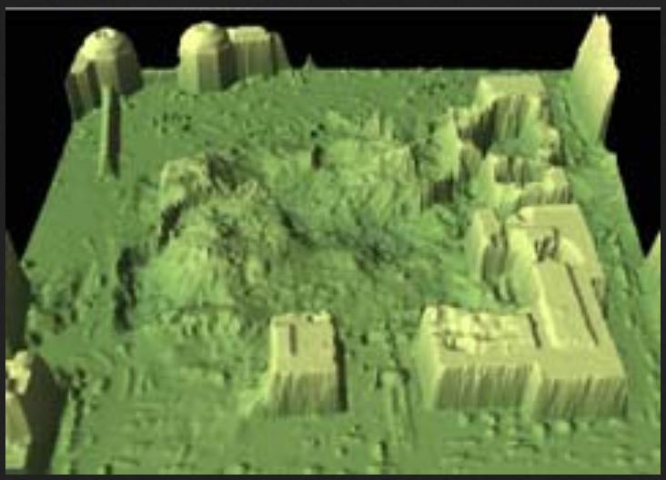
The second, TIN (Triangulated Irregular Network) Constructed from September 19, 2001 LIDAR data :
The key on the left, measured in feet, shows ranges of elevation of the debris which are color-coded:
-75 to -55, -55 to -35, -35 to -15, -15 to 5, 5 to 25, 25 to 50, 50 to 75, 75 to 100, 100 to 150, 150 to 200, 200 to 300, 300 to 400, 400 to 1381. Although the LIDAR maps are coarsely quantized in height, note the excellent agreement with WTC 7 its debris mound and the contour plot compiled by the author from photographs. (35)
The estimate of an average 2 story debris height for the North Tower and 1 story debris height for the South Tower based upon photographs of the rubble are consistent with the LIDAR topology map.(46)
Those two photos and the rest of the photos prove sufficiently that about 60 % of the towers debris filled the sub-levels plus 1 or two above ground stories, and 40 % of the debris fell outside the footprints of the two Twin towers.
There was no impossible dustification of steel on 9/11/2001. PERIOD.
Read pages 44 and 45 for those arguments.
Solving The Great Steel Caper:
DEW -Demolition Contrary Evidence
By Dr. Gregory S. Jenkins :
journalof911studies.com...
Page 38 of 63 : The Mueser Rutledge Consulting Engineers damage assessment schematics show that all 6 sub-levels (7 stories) across the entire footprint of the towers likely collapsed.
I will show in the remainder of this section that the photographic record of GZ debris removal from September 2001 through May 2002 clearly depicts all sub-levels directly beneath both towers collapsed and filled with debris. The amount of debris which compacted into the sub-levels across the footprints of the towers will be shown to be the majority of the material associated with the towers.
Notes on page 42 of 63 under those two evidential photos.
The first, side by side, one of the sub-levels of the Twin Towers at construction, one taken 03-11-2002) :
(Left) Foundation of exterior columns during construction.
(Right) 3-11-02: South tower lower level. All levels down to the foundation were filled with debris.
The second, TIN (Triangulated Irregular Network) Constructed from September 19, 2001 LIDAR data :
The key on the left, measured in feet, shows ranges of elevation of the debris which are color-coded:
-75 to -55, -55 to -35, -35 to -15, -15 to 5, 5 to 25, 25 to 50, 50 to 75, 75 to 100, 100 to 150, 150 to 200, 200 to 300, 300 to 400, 400 to 1381. Although the LIDAR maps are coarsely quantized in height, note the excellent agreement with WTC 7 its debris mound and the contour plot compiled by the author from photographs. (35)
The estimate of an average 2 story debris height for the North Tower and 1 story debris height for the South Tower based upon photographs of the rubble are consistent with the LIDAR topology map.(46)
Those two photos and the rest of the photos prove sufficiently that about 60 % of the towers debris filled the sub-levels plus 1 or two above ground stories, and 40 % of the debris fell outside the footprints of the two Twin towers.
There was no impossible dustification of steel on 9/11/2001. PERIOD.
A summary of the current arguments compiled from the author’s current and previous reports (35) which have not been addressed by DEW-proponents are as follows:
Read pages 44 and 45 for those arguments.
waypastvne, posted on Oct, 22 2013 @ 04:10 AM
link : www.abovetopsecret.com...
It has been done by many of us for a long time already, did you decide to ignore them, or did you not read them? HERE IT IS :
LaBTop's LONG LIST OF UNDENIABLE EVIDENCES THAT 9/11 WAS A BLACK OPERATION.
The only question that's left : who were the real perpetra(i)tors. Who gave the orders, and who carried them out.
I will gladly debate any of my evidence, and that from other real truthers their many evidences, with you.
Up till now, nobody of the Official Stories believers did. Or could counter them.
Perhaps it will change your mind back to your original correct gut-feeling again....
link : www.abovetopsecret.com...
I have been waiting years for the Truth movement to put together all their truther facts and tell us what happened on 9/11 in a way that doesn't make me giggle.
When you put all the truther facts together you get something like this:
Everyone will eventually know that al-Qaeda never existed, acted under the control of the US Government and acted on its own initiative but with the passive complicity of the US Government to hijack planes, not hijack planes and try but fail to hijack planes, that the US Government, a small rogue element within the US Government, and Mossad operating without the knowledge of the US Government crashed the planes into the towers under remote control, crashed different planes into the towers under remote control, didn't crash any planes into the towers but projected holograms of the planes crashing into the towers, and didn't crash or project anything but convinced everyone that planes hit the towers by showing it to them on TV, after which the towers were blown up by explosives that made lots of explosions that everybody heard, weakened by thermite silently which explains why nobody heard any explosions, blown up by nuclear weapons in the cellar which started collapses from the top, and turned entirely to dust by energy beams from space which is why there was no debris, and that the debris pile was then kept hot for months by thermite that hadn't reacted when it all reacted to bring the towers down, and all the steel that wasn't there was immediately taken to China which is why the steel recovered shows signs of explosives, melting and dustification, and a plane, a missile, a different plane and a hologram all crashed into the Pentagon except that it was only one of them, or pulled up at the last second and flew over the Pentagon, leaving a neat 12 foot hole that caused 90 feet of the bit of the wall that had recently been reinforced to collapse, and another plane was shot down at Shanksville then landed in Cleveland leaving no wreckage at Shanksville that was spread out over too large an area to be from a crash even though it didn't exist. That's what really happened, and some day everyone will figure out how obvious it all is.
Dave Rogers
It's been a couple of years since I asked you to put the facts together, are you able to do it now?
It has been done by many of us for a long time already, did you decide to ignore them, or did you not read them? HERE IT IS :
LaBTop's LONG LIST OF UNDENIABLE EVIDENCES THAT 9/11 WAS A BLACK OPERATION.
The only question that's left : who were the real perpetra(i)tors. Who gave the orders, and who carried them out.
I will gladly debate any of my evidence, and that from other real truthers their many evidences, with you.
Up till now, nobody of the Official Stories believers did. Or could counter them.
Perhaps it will change your mind back to your original correct gut-feeling again....
You know what baffles me the most?
The enormous dis-interest in my above list.
It is totally devastating to any OS believers debate with 9/11 truth proponents, but the latter never used it, as far as I know, against the former.
Do they not trust themselves, to be able to defend these evidences against their opponents?
That would be a strong indicator that most, if not all educated, intelligent, longtime 9/11 debaters have left this forum....or ignored it lately.
I happened to witness the same effect of a too heavy inflow of juvenile, non-professional and/or immature newbies at a former forum I was part of.
It caused the slow but certain death of that highly informative and frontline forum.
It is a pity, that such events, unsolved by forums staffs, have such a devastating effect on former intelligent debates.
Long good post by waypastvne about Shanksville and Pentagon debris. Flight UAL93 and AAL77.
www.abovetopsecret.com...
List of 85 video tapes confiscated by various US LEO and military institutions.
www.abovetopsecret.com...
WTC North Tower compilation :
www.abovetopsecret.com...
Documentary on Israeli connection to 911 two hours long :
www.abovetopsecret.com...
new topics
-
Welp...Happy New Year!!
General Chit Chat: 16 minutes ago -
Vehicle Strikes people in New Orleans
Mainstream News: 1 hours ago -
The Hand that Rocks the Cradle - Labour Plans “diversities of our society” Curriculum Change
Regional Politics: 1 hours ago -
SCOTUS Chief Justice JOHN ROBERTS Ends 2024 Describing His Fears for Safety of U.S. Judges.
Above Politics: 10 hours ago
top topics
-
US disburses $3.4 billion in budget aid for Ukraine, Yellen says
US Political Madness: 17 hours ago, 13 flags -
How we've changed in 100 years
Ancient & Lost Civilizations: 16 hours ago, 8 flags -
Vehicle Strikes people in New Orleans
Mainstream News: 1 hours ago, 5 flags -
SCOTUS Chief Justice JOHN ROBERTS Ends 2024 Describing His Fears for Safety of U.S. Judges.
Above Politics: 10 hours ago, 3 flags -
The Hand that Rocks the Cradle - Labour Plans “diversities of our society” Curriculum Change
Regional Politics: 1 hours ago, 1 flags -
Welp...Happy New Year!!
General Chit Chat: 16 minutes ago, 0 flags
active topics
-
Vehicle Strikes people in New Orleans
Mainstream News • 10 • : Flyingclaydisk -
I dont understand what i just witnessed
Social Issues and Civil Unrest • 22 • : TheMisguidedAngel -
Welp...Happy New Year!!
General Chit Chat • 0 • : Flyingclaydisk -
How we've changed in 100 years
Ancient & Lost Civilizations • 13 • : 38181 -
President Carter has passed
Mainstream News • 34 • : Skinnerbot -
The Silent Motion…
Short Stories • 4 • : Naftalin -
The Hand that Rocks the Cradle - Labour Plans “diversities of our society” Curriculum Change
Regional Politics • 5 • : gortex -
New UK Petition - Close the borders! Suspend ALL immigration for 5 years!
Regional Politics • 16 • : gortex -
The C.D.C. Says There Was NO INFLUENZA Worth Reporting for the 2020-2021 Flu Season.
Diseases and Pandemics • 61 • : BedevereTheWise -
Mood Music Part VI
Music • 3773 • : BrucellaOrchitis