It looks like you're using an Ad Blocker.
Please white-list or disable AboveTopSecret.com in your ad-blocking tool.
Thank you.
Some features of ATS will be disabled while you continue to use an ad-blocker.
share:
reply to post by muzzy
Thanks muzzy (I had already checked that site out)
I was just curious about the 'felt it' reports, and was hoping for some sort of scientific explanation
Rainbows
Jane
Thanks muzzy (I had already checked that site out)
I was just curious about the 'felt it' reports, and was hoping for some sort of scientific explanation
Rainbows
Jane
Originally posted by muzzy
reply to post by BO XIAN
yeah, you would think they are all related to the same thing wouldn't you, ie expansion of the Australian Plate.
then out of left field .................... Mozambique
edit on 12-2-2012 by muzzy because:to add this .......
I hadn't looked at this page for a while, looks like they have taken it past the Beta version and this is going to be the style. I like it About time!
USGS Latest Earthquakes - Mappingedit on 12-2-2012 by muzzy because: (no reason given)
Ahhh but Mozambique was not in that line of quakes.
Why would so many quakes line up like that in such a short time-span and so close in magnitude.
That still seems quite unusual, to this layman.
So that's the new version of the USGS website?
Hmmmm
Been a while for Mozambique
According to ANSS last Mag 5 was;
Ref: 2010101420
Date/Time: 2010/10/14 10:03:30
Lat: -10.32 Long: 42.783
Magnitude: 5.2 Mb
Depth: 10 km
Catalog Source: NEI
Interactive Map
According to ANSS last Mag 5 was;
Ref: 2010101420
Date/Time: 2010/10/14 10:03:30
Lat: -10.32 Long: 42.783
Magnitude: 5.2 Mb
Depth: 10 km
Catalog Source: NEI
Interactive Map
edit on 12-2-2012 by muzzy because: pasted wrong last quake
This event has been reviewed by a seismologist.
Magnitude
4.4
Date-Time
Monday, February 13, 2012 at 04:47:12 UTC
Sunday, February 12, 2012 at 08:47:12 PM at epicenter
Time of Earthquake in other Time Zones
Location
38.790°N, 122.745°W
Depth
0.4 km (~0.2 mile)
Region
NORTHERN CALIFORNIA
Distances
5 km (3 miles) E (100°) from The Geysers, CA
5 km (3 miles) SSW (202°) from Cobb, CA
5 km (3 miles) WNW (290°) from Anderson Springs, CA
USGS
At the Geysers geothermal complex. 4.4 then 2.6. I thought I read before that anything over a 2.5 is uncommon for the year usually - for the complex that is.
edit on 12/2/12 by murkraz because: (no reason given)
Originally posted by murkraz
This event has been reviewed by a seismologist.
Magnitude
4.4
Date-Time
Monday, February 13, 2012 at 04:47:12 UTC
Sunday, February 12, 2012 at 08:47:12 PM at epicenter
Time of Earthquake in other Time Zones
Location
38.790°N, 122.745°W
Depth
0.4 km (~0.2 mile)
Region
NORTHERN CALIFORNIA
Distances
5 km (3 miles) E (100°) from The Geysers, CA
5 km (3 miles) SSW (202°) from Cobb, CA
5 km (3 miles) WNW (290°) from Anderson Springs, CA
USGS
At the Geysers geothermal complex. 4.4 then 2.6. I thought I read before that anything over a 2.5 is uncommon for the year usually - for the complex that is.
edit on 12/2/12 by murkraz because: (no reason given)
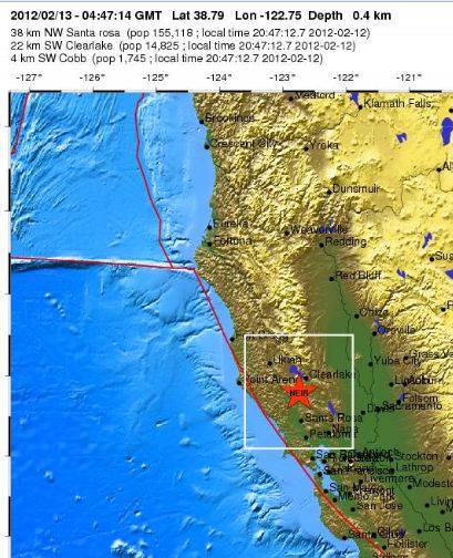
And hows this for precognitive abilities. The post by Olivine was early this morning, talking bout Cobb and Geysers. A few miles either way. Not bad.
Originally posted by Olivine
Might be possible if you looked at stations a little farther south, near Clear Lake, The Geysers, Cobb Mtn and Lake Pillsbury.
To which I said;
You mean like in this area
I know we were talking about magmatic tremors, but heres an EQ right where you were talkin. smack dab. Hmmmm? precog?
edit on
13-2-2012 by zworld because: (no reason given)
source(www.emsc-csem.org...
TextMagnitude mb 5.5 Region COSTA RICA Date time 2012-02-13 10:55:11.5 UTC Location 9.24 N ; 84.12 W Depth 23 km Distances 77 km S San josé (pop 335,007 ; local time 04:55:11.5 2012-02-13) 47 km W San isidro (pop 34,877 ; local time 04:55:11.5 2012-02-13) 24 km S Quepos (pop 7,810 ; local time 04:55:11.5 2012-02-13)
and USGS
source(earthquake.usgs.gov...
TextMagnitude 6.1 Date-Time Monday, February 13, 2012 at 10:55:12 UTC Monday, February 13, 2012 at 04:55:12 AM at epicenter Location 9.254°N, 84.008°W Depth 33.6 km (20.9 miles) Region COSTA RICA Distances 81 km (50 miles) S (175°) from SAN JOSE, Costa Rica 137 km (85 miles) SW (233°) from Limon, Costa Rica 193 km (120 miles) W (268°) from Bocas del Toro, Panama Location Uncertainty horizontal +/- 15.8 km (9.8 miles); depth +/- 5.5 km (3.4 miles) Parameters NST=447, Nph=452, Dmin=83.5 km, Rmss=1.49 sec, Gp= 43°, M-type=regional moment magnitude (Mw), Version=9 Source Magnitude: USGS NEIC (WDCS-D) Location: USGS NEIC (WDCS-D) Event ID usb0007ztb
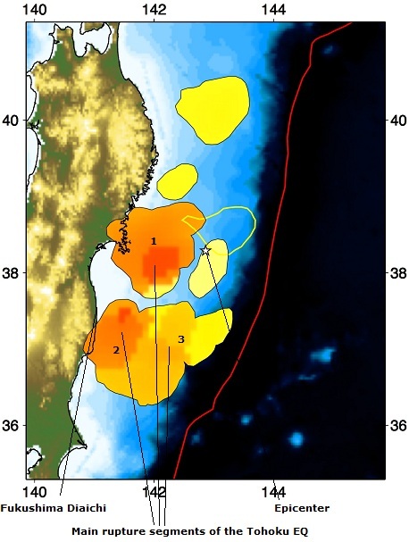
This concerns the concept of an epicenter as the focal point of energy release. According to the Harvard dept of Seismology it isnt the focal point at
all, and in fact the Fukushima F1 nuclear plant may have received a much greater shaking than we thought.
This website is fascinating for those studying the Tohoku EQ. seismology.harvard.edu...
On the above page they have a timelapse animation that is very informative. The pic below shows where the epicenter is, yet none of the three initial ruptures that make up the three accepted phases of the EQ were even touching the epicenter. So trying to figure EQ size by the time the EQ made its way from the epicenter doesnt work.

Note that the second rupture produced the second shake that workers describe as the main shake. This is the rupture that did the most damage. The magnitude of this segment of the rupture is more indicative of what hit Daiichi.
I think this is more like what will happen when the CSZ goes. A series of ruptures that may end up producing a 9+ EQ, but doesn't have a centralized epicenter where the worst shaking is. In other words, what we may experience is a bunch of 7.5 level EQs spread up and down the coast as the zone ruptures.
This also explains why the damage wasn't as great as some thought it would be from a 9+ EQ.
This website is fascinating for those studying the Tohoku EQ. seismology.harvard.edu...
On the above page they have a timelapse animation that is very informative. The pic below shows where the epicenter is, yet none of the three initial ruptures that make up the three accepted phases of the EQ were even touching the epicenter. So trying to figure EQ size by the time the EQ made its way from the epicenter doesnt work.

The figure on the left shows the relative amount of energy release from various locations that radiated energy during the first 25 minutes (darker orange showing higher energy release). The largest energy release occurs downdip of the epicentre, and the regions south of the epicentre release more energy than segments to the north (partially due to multiple large aftershocks on Mw 9.0 earthquake). The amount of energy release from different segments vary considerably (right), and the colours are not simple relative amplitude, but logarithm of the relative amplitude. Consequently, the saturation levels of the colour scale for the animation above is time dependent to bring out different episodes. Even though the segments are not continuous, the total extent of the collection of events is about 480 km, and the width is about 170 km.
Note that the second rupture produced the second shake that workers describe as the main shake. This is the rupture that did the most damage. The magnitude of this segment of the rupture is more indicative of what hit Daiichi.
I think this is more like what will happen when the CSZ goes. A series of ruptures that may end up producing a 9+ EQ, but doesn't have a centralized epicenter where the worst shaking is. In other words, what we may experience is a bunch of 7.5 level EQs spread up and down the coast as the zone ruptures.
This also explains why the damage wasn't as great as some thought it would be from a 9+ EQ.
edit on 13-2-2012 by zworld because: (no reason
given)
edit on 13-2-2012 by zworld because: (no reason given)
reply to post by jadedANDcynical
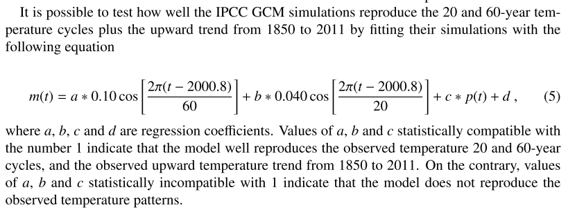
Thanks for the link jAc. Looks fascinating and I do believe is connected to earthquakes as let's face it everything is connected. Better still it is another nail in the IPCC coffin.
This bit is really interesting!

Well, um at least I think it is. I don't think I have removed all the glaze from my eyeballs yet, but the optic nerve is more or less untwisted now. Sometimes I wish I had a brain.
Thanks for the link jAc. Looks fascinating and I do believe is connected to earthquakes as let's face it everything is connected. Better still it is another nail in the IPCC coffin.
This bit is really interesting!

Well, um at least I think it is. I don't think I have removed all the glaze from my eyeballs yet, but the optic nerve is more or less untwisted now. Sometimes I wish I had a brain.
reply to post by Aromaz
That will be Nibiru then.
Or the Sun's evil brown dwarf twin.
Seriously however I have no idea. Maybe God accidentally squashed it a little when he made it 6000 years ago
www.physicsforums.com...
Yes/No/Maybe?
What exactly causes the ecliptical orbits of Jupiter; and all the other planets?
That will be Nibiru then.
Or the Sun's evil brown dwarf twin.
Seriously however I have no idea. Maybe God accidentally squashed it a little when he made it 6000 years ago
Over long periods of time, the Earth's eccentricity changes. It goes from almost a perfect circle to about twice what it is now. I forget how long it takes to do this. But Jupiter and Venus are primarily responsible. Jupiter is the reason that Mars has such a high eccentricity. Mars' eccentricity also periodically changes from nearly-circular to even greater than it is now. Being closer to Jupiter, its maximum eccentricity is much greater than Earth's.
www.physicsforums.com...
Yes/No/Maybe?
edit on 13/2/2012 by PuterMan because: (no reason given)
reply to post by dreamfox1
Tell me, since I don't read Japanese, is there some good reason why this 'realtime' broadcast has a web address that ends in the word -test?
Just askin'
Tell me, since I don't read Japanese, is there some good reason why this 'realtime' broadcast has a web address that ends in the word -test?
Just askin'
I think we just had another small quake in Virginia. I don't see it on USGS, but I'm certain I just felt the familiar rocking.
ETA: ...Or maybe I'm losing it I see 2 eq sigs on US.CBN.BHZ -- the largest was only +/- 30 mic/sec. That could have been construction work or something. Meh...
ETA: ...Or maybe I'm losing it I see 2 eq sigs on US.CBN.BHZ -- the largest was only +/- 30 mic/sec. That could have been construction work or something. Meh...
edit on 2/13/2012 by Olivine because: (no reason given)
reply to post by Olivine
Something is showing. But doggone it, I don't know how to do more than post a link!!!
www.iris.edu...
WOQ
ETA: Looks even better here.
folkworm.ceri.memphis.edu...
Something is showing. But doggone it, I don't know how to do more than post a link!!!
www.iris.edu...
WOQ
ETA: Looks even better here.
folkworm.ceri.memphis.edu...
edit on 13-2-2012 by wasobservingquietly because: (no reason
given)
reply to post by wasobservingquietly
Thanks WOQ At least someone else sees it.
I'm just edgy I guess. Not enough sleep last night.
Thanks WOQ At least someone else sees it.
I'm just edgy I guess. Not enough sleep last night.
Just got hit with a quake in the Eureka CA area at 1:08. Dont know specifics yet. Fairly good jolt but short lived.

Now its TAs turn to be spot on the money. We got some serious precogs in ATS.

Now its TAs turn to be spot on the money. We got some serious precogs in ATS.
edit on 13-2-2012 by zworld because: (no reason given)
reply to post by zworld
fascinating
emphasis' mine
fascinating
In the strict definition of foreshocks and aftershocks (earthquake occurring on the rupture plane of the mainshock before and after the mainshock hypocentral time), these earthquakes are not foreshock and aftershocks, but cascading failure of different segments of the plate interface. Almost all of the triggered earthquakes start at the boundary with previous earthquake, and propagate into regions that have not slipped. This observation suggests that the Mw 9.0 earthquake could have been larger (as large as 9.4) if all the segments failed within a single event.
emphasis' mine
WHOA!!!!!!
earthquake.usgs.gov...
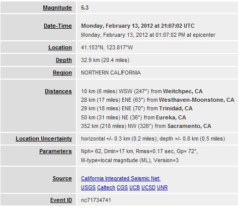
Magnitude 5.5 Date-Time Monday, February 13, 2012 at 21:07:02 UTC Monday, February 13, 2012 at 01:07:02 PM at epicenter Location 41.153°N, 123.817°W Depth 32.9 km (20.4 miles) Region NORTHERN CALIFORNIA Distances 10 km (6 miles) WSW (247°) from Weitchpec, CA 28 km (17 miles) ENE (63°) from Westhaven-Moonstone, CA 29 km (18 miles) ENE (70°) from Trinidad, CA 50 km (31 miles) NE (36°) from Eureka, CA 352 km (218 miles) NW (326°) from Sacramento, CA Location Uncertainty horizontal +/- 0.3 km (0.2 miles); depth +/- 0.8 km (0.5 miles) Parameters Nph= 62, Dmin=17 km, Rmss=0.17 sec, Gp= 72°, M-type=regional moment magnitude (Mw), Version=4 Source California Integrated Seismic Net: USGS Caltech CGS UCB UCSD UNR Event ID nc71734741
earthquake.usgs.gov...
Edit: ^Beat me.
This event has been reviewed by a seismologist.
Magnitude
5.5
Date-Time
Monday, February 13, 2012 at 21:07:02 UTC
Monday, February 13, 2012 at 01:07:02 PM at epicenter
Location
41.153°N, 123.817°W
Depth
32.9 km (20.4 miles)
Region
NORTHERN CALIFORNIA
Distances
10 km (6 miles) WSW (247°) from Weitchpec, CA
28 km (17 miles) ENE (63°) from Westhaven-Moonstone, CA
29 km (18 miles) ENE (70°) from Trinidad, CA
50 km (31 miles) NE (36°) from Eureka, CA
352 km (218 miles) NW (326°) from Sacramento, CA
edit on 13/2/12 by murkraz because: (no reason given)
reply to post by zworld
congratulations, its been a long time since a 5+ for California.
yet to be downgraded
congratulations, its been a long time since a 5+ for California.
yet to be downgraded
new topics
-
My Retirement
General Chit Chat: 42 minutes ago -
‘Something horrible’: Somerset pit reveals bronze age cannibalism
Ancient & Lost Civilizations: 1 hours ago -
Spiritual Solstice
Short Stories: 3 hours ago
top topics
-
'Mass Casualty event' - Attack at Christmas market in Germany
Mainstream News: 14 hours ago, 26 flags -
Search to Resume for MH 370
Disaster Conspiracies: 16 hours ago, 5 flags -
Sue Gray, Sir Keir Starmer's former Chief of Staff, Nominated for Peerage
Regional Politics: 17 hours ago, 3 flags -
My Retirement
General Chit Chat: 42 minutes ago, 3 flags -
‘Something horrible’: Somerset pit reveals bronze age cannibalism
Ancient & Lost Civilizations: 1 hours ago, 1 flags -
Spiritual Solstice
Short Stories: 3 hours ago, 0 flags
active topics
-
My Retirement
General Chit Chat • 2 • : billxam1 -
The Truth Behind the Manchester Airport "Police Assault" Video
Social Issues and Civil Unrest • 57 • : gortex -
Biden Nationalizes Another 50,000+ Student Loans as He Heads for the Exit
US Political Madness • 14 • : butcherguy -
'Mass Casualty event' - Attack at Christmas market in Germany
Mainstream News • 107 • : cherokeetroy -
‘Something horrible’: Somerset pit reveals bronze age cannibalism
Ancient & Lost Civilizations • 1 • : Naftalin -
Sue Gray, Sir Keir Starmer's former Chief of Staff, Nominated for Peerage
Regional Politics • 3 • : Freeborn -
Search to Resume for MH 370
Disaster Conspiracies • 8 • : charlyv -
Spiritual Solstice
Short Stories • 2 • : Naftalin -
Mood Music Part VI
Music • 3752 • : BrucellaOrchitis -
An Interesting Conversation with ChatGPT
Science & Technology • 31 • : BrucellaOrchitis

