It looks like you're using an Ad Blocker.
Please white-list or disable AboveTopSecret.com in your ad-blocking tool.
Thank you.
Some features of ATS will be disabled while you continue to use an ad-blocker.
share:
reply to post by Hellas
Yea they have
earthquake.usgs.gov...
It is a discounted one.
EMSC have given it a hefty discount as well
www.emsc-csem.org...
Better hurry now before they are all sold out.
Yea they have
earthquake.usgs.gov...
It is a discounted one.
EMSC have given it a hefty discount as well
www.emsc-csem.org...
Better hurry now before they are all sold out.
edit on 14/2/2012 by PuterMan because: (no reason given)
reply to post by PuterMan
lol!!
EMSC
lol!!
Magnitude mb 5.0
Region VANUATU
Date time 2012-02-14 18:07:55.0 UTC
Location 18.08 S ; 167.13 E
Depth 27 km
Distances 1194 km W Suva (pop 199,455 ; local time 06:07:55.5 2012-02-15)
130 km W Vila (pop 35,901 ; local time 05:07:55.5 2012-02-15)
EMSC
reply to post by crappiekat
Sorry what is it you are asking? I am not sure what it is that is rattling you.
reply to post by LorraineRKO
I think you may also get a discount on that Mag 6.0 off Japan today. USGS has it on offer at 5.7 Mw and 5.8 Mw now, but there is only one remaining on stock. Still 6.0 on the web site however so this is an 8 day change candidate I think.
Talking of discounts I said earlier "That will be going up I think. I am guessing 6.7" in response to the 6.5 Solomon Islands as I thought the phase data looked to be averaging at least that in mb, and yet they have come in a 6.4 Mw. :shk: I don't think I will ever understand how they work these out.
reply to post by PuterMan
Sorry for interfering P Man but I think they don't know either.
I don't think I will ever understand how they work these out
reply to post by PuterMan
Thank you for your reply. I have been watching the seimo's for cali, and it looks to me like something is building up. After reading Trueamericans thread regarding the region, his words are making me alittle nervous. My question is, Is there in fact something building up or am I just getting too excited.
We have a friend who lives in the northern region of the state. She is old and insists the earthquake rattles don't bother her. But we would really like her to move closer to family. This is the reason I get alittle excited when things start rattling more than normal in the area.
edit on
14-2-2012 by crappiekat because: (no reason given)
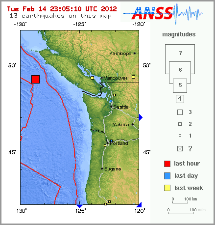
This event has been reviewed by a seismologist.
Magnitude: 4.2
Date-Time:
Tuesday, February 14, 2012 at 22:54:40 UTC
Tuesday, February 14, 2012 at 02:54:40 PM at epicenter
Location: 49.214°N, 128.751°W
Depth: 10 km (6.2 miles)
Region: VANCOUVER ISLAND, CANADA REGION
Distances:
191 km (118 miles) SSW of Port Hardy, British Columbia, Canada
235 km (146 miles) W of Ucluelet, British Columbia, Canada
268 km (166 miles) WSW of Campbell River, British Columbia, Canada
405 km (251 miles) WNW of VICTORIA, British Columbia, Canada
Location Uncertainty: horizontal +/- 25 km (15.5 miles); depth +/- 2.7 km (1.7 miles)
Parameters: NST= 33, Nph= 33, Dmin=268.3 km, Rmss=0.65 sec, Gp=212°,
M-type=body wave magnitude (Mb), Version=9
Source:
Magnitude: USGS NEIC (WDCS-D)
Location: USGS NEIC (WDCS-D)
Event ID: usb00080ej
USGS
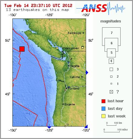
Edit: Berkeleygal beat me to the image whilst i was trying to figure out how to post it
edit on 14-2-2012 by skitzspiricy because: (no
reason given)
reply to post by crappiekat
OMMB.NN..HHZ.2012.045 has a couple of nice small ones but other than that I cannot see anything that strikes me as out of the ordinary on the 25 of so i looked at.
OMMB.NN..HHZ.2012.045 has a couple of nice small ones but other than that I cannot see anything that strikes me as out of the ordinary on the 25 of so i looked at.
2.0 2012/02/14 23:55:51 38.800 -122.734 2.1 4 km ( 3 mi) SSW of Cobb, CA
2.4 2012/02/14 23:51:27 37.248 -118.391 14.5 3 km ( 2 mi) S of Wilkerson, CA
2.1 2012/02/14 23:50:47 37.534 -118.919 10.1 13 km ( 8 mi) SSE of Mammoth Lakes, CA
2.2 2012/02/14 23:48:09 35.533 -120.791 4.7 8 km ( 5 mi) WSW of Templeton, CA
2.5 2012/02/14 23:48:02 37.589 -118.457 10.7 20 km ( 12 mi) E of Toms Place, CA
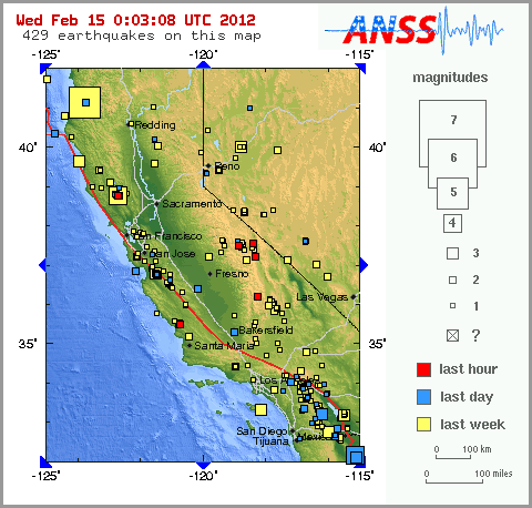
lighting up like crazy - five 2+mags in 7 minutes - 3 at mammoth
Originally posted by berkeleygal
We're rockin and rollin now berkeleygal.
reply to post by zworld
Type: Earthquake
6 minutes ago
Magnitude: 5.9
DateTime: Wednesday February 15 2012, 03:31:21 UTC
Region: off the coast of Oregon
Depth: 12 km
Source: USGS Feed
Type: Earthquake
6 minutes ago
Magnitude: 5.9
DateTime: Wednesday February 15 2012, 03:31:21 UTC
Region: off the coast of Oregon
Depth: 12 km
Source: USGS Feed
ON EDIT: The PNSN has changed their map to now show just one quake.
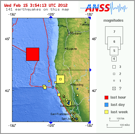
My god. WTF. Therre were two 5.9 EQs back to back off Oregon coast just now.
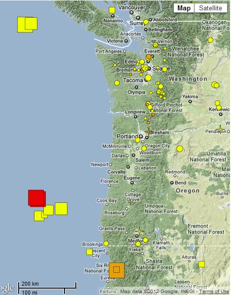
My god. WTF. Therre were two 5.9 EQs back to back off Oregon coast just now.

edit on 14-2-2012 by zworld because: (no reason given)
edit on 14-2-2012 by zworld because: (no
reason given)
USGS says one
earthquake.usgs.gov...
Magnitude
6.0
Date-Time
Wednesday, February 15, 2012 at 03:31:20 UTC
Tuesday, February 14, 2012 at 07:31:20 PM at epicenter
Time of Earthquake in other Time Zones
Location
43.536°N, 127.381°W
Depth
10 km (6.2 miles)
Region
OFF THE COAST OF OREGON
Distances
256 km (159 miles) W of Coos Bay, Oregon
293 km (182 miles) WSW of Newport, Oregon
302 km (187 miles) NW of Brookings, Oregon
380 km (236 miles) WSW of SALEM, Oregon
Location Uncertainty
horizontal +/- 19.7 km (12.2 miles); depth +/- 6.2 km (3.9 miles)
Parameters
NST=205, Nph=211, Dmin=282.8 km, Rmss=1.15 sec, Gp=180°,
M-type=regional moment magnitude (Mw), Version=6
Source
Magnitude: USGS NEIC (WDCS-D)
Location: USGS NEIC (WDCS-D)
Event ID
usb00080ib
earthquake.usgs.gov...

edit on 14-2-2012 by berkeleygal because: (no reason given)
Concerned about the Oregon Quakes.
Two in a row, not good.
Thank you for posting, will return
for updates.
Two in a row, not good.
Thank you for posting, will return
for updates.
Originally posted by berkeleygal
USGS says one
Yeah, now PNSN is in line with that. Theyve changed their map to show only one. Originally they posted two that were a couple of minutes apart and two miles difference in depth. But when I went back to get more data they had gone to just one.
Folks - Happy end of V-Day = Please those of you on the northwest of the USA take special note of the ongoing issues set forth above = this is a very
serious issue that all of you need to pay special attention to and inform your neighbors and friends who are not in the know!!!! Please things have
gone past interesting and of special interest into IMO a real RED ZONE. Don't mean to scare anyone - but - it is what it is and at this point -
really, anything can happen = the zone/fault is --- - - idk - - feel it -- quivering / vibrating / snapping / = ready to bust - to many larger one all
over the area in to short at time = take a vacation!!
When did they take the seismograph displays off USGS?
gone
Past
Past 8–30 days
Significant Earthquakes
Earthquake Lists & Maps
Search for an Earthquake
Present
Real-time - CA/NV
Real-time - USA
Real-time - Worldwide
About Earthquake Maps
KML / RSS Feeds & Data
Earthquake Notifications
Did You Feel It?
ShakeMaps
PAGER
Earthquake Animations
Google Gadget
TED-Twitter EQ Dispatch
Future
Earthquake Scenarios
Prediction
Probabilities
Location
Info by State/Territory
Info by Country/Region
gone
Originally posted by crazydaisy
Concerned about the Oregon Quakes.
Two in a row, not good.
Thank you for posting, will return
for updates.
Yep, especially with the one in/ near Canada around the same time...
Couple this with the 5.9 in Cali yesterday, and the west coast has had quite the action in the last 24 hours.
Oregon - a specific location in the USA that has been too often in the news over this past few weeks with all sorts of strange reports. And I am not
even from or in the USA - just about opposite side of Globe in Thailand.
I know the jury is still out on the strange boxes; but there definatley seems to be an increased number of UFO/USO related reports. Is the stress build up on the fault lines really strong? Looking at increased number of stronger shakes up an down the same plates it seems to call for close inspection.
I know the jury is still out on the strange boxes; but there definatley seems to be an increased number of UFO/USO related reports. Is the stress build up on the fault lines really strong? Looking at increased number of stronger shakes up an down the same plates it seems to call for close inspection.
May I take this opportunity to remind all you folks with short memories that on the 10th Jan 2010 there was a 6.5 not far from the current
epicentre and people did not jump up and down as much as they are today.
earthquake.usgs.gov...
Of course we had the usual OMG is this just before the big one?
And guess what? We are all still here to do it all again.
There was a 5.2 and a series of 4+ in February of 2011. This particular on has been on the boil since December 2010.
Vancouver popped off a 6+ and yup, we are still here. The warnings and portends of doom are getting way over the top recently, but I have to say that Dutchsinse's offering on this event is actually almost reasonable. Perhaps he is learning. Everyone needs to take a step back and calm down a bit. This does not mean you should not have your emergency plans prepared, but for goodness sake just stop psyching the whole thing up out of proportion.
I say the plates are still adjusting after Japan, but then I am not an expert and I must apologise for not being such a doom monger as some. 120 Octane doom just is not my style.
Yes something big will happen off the coast, but it is not going to be tomorrow, or next week, or next month, and probably not even in the next year - 21 Dec 2012 maybe
To add: If you want something to get worked up about go and study the Sun. What is (or perhaps one should say is not) happening with our Sun is way more serious than a small earthquake of Oregon and will have far more effect on ALL our lives in the the next few decades.
By the way this will go down, or back down to 5.9 on the 8th day maybe even 5.8. Take a look at the tensor solutions.
earthquake.usgs.gov...
earthquake.usgs.gov...
Those don't often get changed. Even if this does not make it with a change on the web site it will be down in the PDE.
earthquake.usgs.gov...
Of course we had the usual OMG is this just before the big one?
And guess what? We are all still here to do it all again.
There was a 5.2 and a series of 4+ in February of 2011. This particular on has been on the boil since December 2010.
Vancouver popped off a 6+ and yup, we are still here. The warnings and portends of doom are getting way over the top recently, but I have to say that Dutchsinse's offering on this event is actually almost reasonable. Perhaps he is learning. Everyone needs to take a step back and calm down a bit. This does not mean you should not have your emergency plans prepared, but for goodness sake just stop psyching the whole thing up out of proportion.
I say the plates are still adjusting after Japan, but then I am not an expert and I must apologise for not being such a doom monger as some. 120 Octane doom just is not my style.
Yes something big will happen off the coast, but it is not going to be tomorrow, or next week, or next month, and probably not even in the next year - 21 Dec 2012 maybe
To add: If you want something to get worked up about go and study the Sun. What is (or perhaps one should say is not) happening with our Sun is way more serious than a small earthquake of Oregon and will have far more effect on ALL our lives in the the next few decades.
By the way this will go down, or back down to 5.9 on the 8th day maybe even 5.8. Take a look at the tensor solutions.
earthquake.usgs.gov...
earthquake.usgs.gov...
Those don't often get changed. Even if this does not make it with a change on the web site it will be down in the PDE.
edit on 15/2/2012 by PuterMan because: (no reason given)
new topics
-
Paramilitary Leaks - John Williams
Whistle Blowers and Leaked Documents: 7 hours ago -
Some sausage, some chicken, some sauce, some onions and some garlic...and some peppers!
Food and Cooking: 8 hours ago -
Hearing more ambulances lately
Medical Issues & Conspiracies: 9 hours ago -
Los Angeles brush fires latest: 2 blazes threaten structures, prompt evacuations
Mainstream News: 9 hours ago -
House Passes Laken Riley Act
Mainstream News: 10 hours ago -
The more I think about it
General Chit Chat: 10 hours ago
top topics
-
House Passes Laken Riley Act
Mainstream News: 10 hours ago, 23 flags -
What Comes After January 20th
Mainstream News: 12 hours ago, 18 flags -
Planned Civil War In Britain May Be Triggered Soon
Social Issues and Civil Unrest: 17 hours ago, 7 flags -
Los Angeles brush fires latest: 2 blazes threaten structures, prompt evacuations
Mainstream News: 9 hours ago, 7 flags -
Let's Buy Greenland
General Chit Chat: 14 hours ago, 6 flags -
Hearing more ambulances lately
Medical Issues & Conspiracies: 9 hours ago, 6 flags -
Paramilitary Leaks - John Williams
Whistle Blowers and Leaked Documents: 7 hours ago, 5 flags -
Those stupid GRAVITE commercials
Rant: 13 hours ago, 5 flags -
Canada as a state .. how would it work?
General Chit Chat: 12 hours ago, 4 flags -
The more I think about it
General Chit Chat: 10 hours ago, 4 flags
active topics
-
Canada as a state .. how would it work?
General Chit Chat • 15 • : Freeborn -
Gravitic Propulsion--What IF the US and China Really Have it?
General Conspiracies • 33 • : Lazy88 -
Let's Buy Greenland
General Chit Chat • 16 • : Freeborn -
-@TH3WH17ERABB17- -Q- ---TIME TO SHOW THE WORLD--- -Part- --44--
Dissecting Disinformation • 3967 • : AianawaQ1320 -
Post A Funny (T&C Friendly) Pic Part IV: The LOL awakens!
General Chit Chat • 8000 • : KrustyKrab -
Los Angeles brush fires latest: 2 blazes threaten structures, prompt evacuations
Mainstream News • 13 • : BeyondKnowledge3 -
House Passes Laken Riley Act
Mainstream News • 16 • : KrustyKrab -
Planned Civil War In Britain May Be Triggered Soon
Social Issues and Civil Unrest • 16 • : Freeborn -
Judge rules president-elect Donald Trump must be sentenced in 'hush money' trial
US Political Madness • 60 • : WeMustCare -
Inca stone masonry at Sacsayhuaman, Ollantaytambo and the Sun Temple
Ancient & Lost Civilizations • 23 • : Hansllune

