It looks like you're using an Ad Blocker.
Please white-list or disable AboveTopSecret.com in your ad-blocking tool.
Thank you.
Some features of ATS will be disabled while you continue to use an ad-blocker.

Atlantis has been discovered?!
page: 24share:
originally posted by: All Seeing Eye
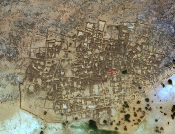
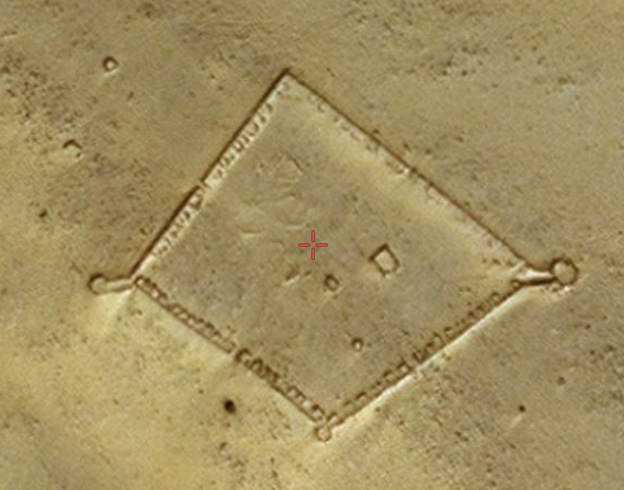
The Portion of it that jets out into the ancient river is just the northern most point, of the dock.
In total, it runs the entire length of the settlement, a little more than 1/4 of a mile that fronts the ancient river.
Again, you don't seem to be able to identify structures in photos. That's the city walls. If you look at photos of the city, you can see a lot of photos of the wall. Very unsuitable for lakefront property.
It was a walled city. Very common in the 11th-16th centuries.
It's not a dock.

originally posted by: Byrd
originally posted by: All Seeing Eye
The Portion of it that jets out into the ancient river is just the northern most point, of the dock.
In total, it runs the entire length of the settlement, a little more than 1/4 of a mile that fronts the ancient river.
Again, you don't seem to be able to identify structures in photos. That's the city walls. If you look at photos of the city, you can see a lot of photos of the wall. Very unsuitable for lakefront property.
It was a walled city. Very common in the 11th-16th centuries.
It's not a dock.
Post your evidence you wish to be considered. Post all the photos from the ancient river looking up, and the photos from the "wall" looking down. Its your position, support it with your evidence.
The early history of Ouadane is uncertain but it is possible that the town prospered from the trans-Saharan gold trade.
en.wikipedia.org...
edit on AMMondayMonday thAmerica/ChicagoAmerica/Chicago0691 by All Seeing Eye because: (no reason
given)
originally posted by: All Seeing Eye
Post your evidence you wish to be considered. Post all the photos from the ancient river looking up, and the photos from the "wall" looking down. Its your position, support it with your evidence.
How about you do that?
So far you have produced no evidence whatsoever to support your fantastical conjecture.
edit on 6-9-2021 by AndyMayhew because: (no reason given)
originally posted by: All Seeing Eye
Post your evidence you wish to be considered. Post all the photos from the ancient river looking up, and the photos from the "wall" looking down. Its your position, support it with your evidence.
Actually, the ball is in your court. I'm not the one disputing their identification. You are.
Wikipedia says it's a walled city. Archaeologists and historians (and ancient travelers) say it's a walled city. I agree.
YOU are the one who has to show that everyone is wrong and it's NOT a walled city and instead is a very extensive dock that goes all around the city... and I think the word, 'dock' doesn't mean what you think it does.
Coastal towns always have lots of evidence, including evidence of maritime life such as piles of fishy remains... easy food to catch and water mark along shorelines and so forth.
I say that the ancient travelers and even modern excavators and tourists certainly know the difference between a port town and a desert town and I am willing to accept their understanding.
You are the one who has to show proof of this ancient lake/sea/whatever you think there was and the time frame (I agree that there was a sea there around 50 million years ago and it dried up sometime before 30 million years ago... before humans evolved.)
The early history of Ouadane is uncertain but it is possible that the town prospered from the trans-Saharan gold trade.
en.wikipedia.org...
...which were land routes. I'm not sure what your point is other than it supports my earlier statements that the area is well-known. has been constantly visited by people since 600 AD, and it's a walled town.
a reply to: Byrd
Plato mentions that the Ringed city was walled in. So it would stand to reason any large towns within the Allotment would also be Walled in. Take note of the many stairways leading down to the lowest levels, and open flat areas with no wall in the area to the south of the jetty that runs for 400 ft. No solid wall is present.
But I have on multiple occasions. Its not millions of years, but only thousands..
www.icr.org...
www.greenprophet.com...
news.yahoo.com...
notrickszone.com...
Now, I have established the timeline, thousands, not millions. And now it is absolutely reasonable to expect to find just 6000 years ago "Someone" having a settlement on a river bank, that had a boat dock. And it is entirely possible it had been abandon for thousands of years to be re-found, re-established, re-purposed into a caravan trading post in the 11th-12th centuries. Hence, "The early history of Ouadane is uncertain".
There is another town that also sits on the bank of a ancient river. But this one, unlike Ouadane does not seem to have been re-discovered, or used in the caravan network. It remains undisturbed, and ignored by UNESCO. No one builds large settlements in a desert. But they are built, by water.
No name settlement.
20°44'21.91"N 12° 0'15.48"W
All dating of present archeological sites (Sahara) must be recomputed given the new Climate information, if one wants to be honest. Or at least allow for the possibility....
Byrd, science has progressed since "We" were in school.
6000 years ago during the wet period there actually could have been a large society in the area, that eventually was lost to time and the desert. Portions rediscovered, and re named, occupied off and on, since the original time period.
These two towns, logically, were established when water was present, because no one would build a town, in the desert, with no available water. Look in the wadi's today, the size of the communities are limited by the amount of water that is available. Man learned how to survive, with what he had. Not, what he once had.
Earlier I pointed out a community that could hold 100,000 plus people, except for one thing. There is no available water to support such a population. Its, illogical... But on the other hand if the ancient river that ran through the area still had running water, would be very logical. It is out of the original "Wet" context. So too, is Ouadane.
Wikipedia says it's a walled city. Archaeologists and historians (and ancient travelers) say it's a walled city. I agree.
Plato mentions that the Ringed city was walled in. So it would stand to reason any large towns within the Allotment would also be Walled in. Take note of the many stairways leading down to the lowest levels, and open flat areas with no wall in the area to the south of the jetty that runs for 400 ft. No solid wall is present.
You are the one who has to show proof of this ancient lake/sea/whatever you think there was and the time frame (I agree that there was a sea there around 50 million years ago and it dried up sometime before 30 million years ago... before humans evolved.)
But I have on multiple occasions. Its not millions of years, but only thousands..
The scientists estimated that past Saharan rainfall was ten times greater than today's between 5,000 and 11,000 years ago.1,2
www.icr.org...
From 11,000 to 5,000 years ago, the 3.5 million square miles of sand and dunes had pockets of water, where hippos cheerfully went about their business. But then, quite drastically, the climate changed, and Massachusetts Institute of Technology (MIT) and Columbia University scientists want to know why.
www.greenprophet.com...
From lakes and grasslands with hippos and giraffes to a vast desert, North Africa's sudden geographical transformation 5,000 years ago was one of the planet's most dramatic climate shifts.
The transformation took place nearly simultaneously across the continent's northern half, a new study finds. The results will appear in an upcoming issue of the journal Earth and Planetary Science Letters.
news.yahoo.com...
Contrary to what many may believe today, the climate of the Sahara desert is far from being steady. Rather, it has gone through profound cyclic changes over the last 10,000 years. For example it was much greener 8000 to 5500 years ago, a time when it was teeming with wildlife.
notrickszone.com...
Now, I have established the timeline, thousands, not millions. And now it is absolutely reasonable to expect to find just 6000 years ago "Someone" having a settlement on a river bank, that had a boat dock. And it is entirely possible it had been abandon for thousands of years to be re-found, re-established, re-purposed into a caravan trading post in the 11th-12th centuries. Hence, "The early history of Ouadane is uncertain".
There is another town that also sits on the bank of a ancient river. But this one, unlike Ouadane does not seem to have been re-discovered, or used in the caravan network. It remains undisturbed, and ignored by UNESCO. No one builds large settlements in a desert. But they are built, by water.
No name settlement.
20°44'21.91"N 12° 0'15.48"W
All dating of present archeological sites (Sahara) must be recomputed given the new Climate information, if one wants to be honest. Or at least allow for the possibility....
Byrd, science has progressed since "We" were in school.
6000 years ago during the wet period there actually could have been a large society in the area, that eventually was lost to time and the desert. Portions rediscovered, and re named, occupied off and on, since the original time period.
These two towns, logically, were established when water was present, because no one would build a town, in the desert, with no available water. Look in the wadi's today, the size of the communities are limited by the amount of water that is available. Man learned how to survive, with what he had. Not, what he once had.
Earlier I pointed out a community that could hold 100,000 plus people, except for one thing. There is no available water to support such a population. Its, illogical... But on the other hand if the ancient river that ran through the area still had running water, would be very logical. It is out of the original "Wet" context. So too, is Ouadane.
originally posted by: AndyMayhew
originally posted by: All Seeing Eye
Post your evidence you wish to be considered. Post all the photos from the ancient river looking up, and the photos from the "wall" looking down. Its your position, support it with your evidence.
How about you do that?
So far you have produced no evidence whatsoever to support your fantastical conjecture.
Then I can only say, your not paying attention.
a reply to: All Seeing Eye
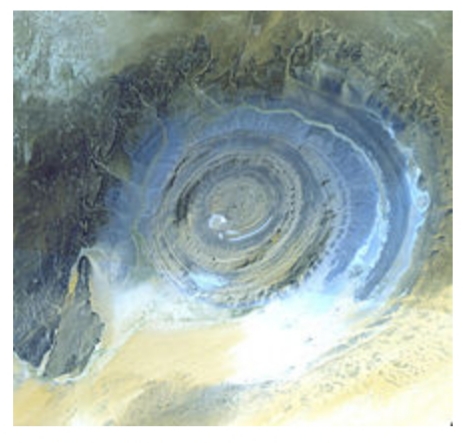
Not to pop the bubble but it's called a "dome" in Geology.
This formation is actually used on the Wikipedia page for domes.
And I'm fairly certain Plato's Atlantis was an ancient volcanic island port in the Aegean sea between Crete and Greece.
en.m.wikipedia.org...
Not to pop the bubble but it's called a "dome" in Geology.
This formation is actually used on the Wikipedia page for domes.
A dome is a feature in structural geology consisting of symmetrical anticlines that intersect each other at their respective apices. Intact, domes are distinct, rounded, spherical-to-ellipsoidal-shaped protrusions on the Earth's surface. However, a transect parallel to Earth's surface of a dome features concentric rings of strata. Consequently, if the top of a dome has been eroded flat, the resulting structure in plan view appears as a bullseye, with the youngest rock layers at the outside, and each ring growing progressively older moving inwards. These strata would have been horizontal at the time of deposition, then later deformed by the uplift associated with dome formation.
The Richat Structure in the Sahara Desert of Mauritania. Briefly considered to be an impact structure, it is now believed by most to be a structural dome.
And I'm fairly certain Plato's Atlantis was an ancient volcanic island port in the Aegean sea between Crete and Greece.
en.m.wikipedia.org...
edit on 6-9-2021 by Degradation33 because: (no reason given)
a reply to: Degradation33
And how do you suppose that precluded people from building structures, city, on top of it? You do realize structures have been found, buried in the second ring, yes?
Might I suggest you start a thread and present your evidence and reasoning for your position. If there is anything I can help you with, just let me know.
Not to pop the bubble but it's called a "dome" in Geology.
And how do you suppose that precluded people from building structures, city, on top of it? You do realize structures have been found, buried in the second ring, yes?
And I'm fairly certain Plato's Atlantis was an ancient volcanic island port in the Aegean sea between Crete and Greece.
Might I suggest you start a thread and present your evidence and reasoning for your position. If there is anything I can help you with, just let me know.
a reply to: Byrd
en.wikipedia.org...
Again, thousands, not millions of years. You will also note the word, mud. Mud, just like mud bricks, requires water. Debris flow is short for flood, mud flood.
Though, the article requires updating concerning man made structures within the Richat.
Artifacts are found, typically redeposited, deflated, or both, in Late Pleistocene to early Holocene gravelly mud, muddy gravel, clayey sand, and silty sand. These sediments are often cemented into either concretionary masses or beds by calcrete. Ridges typically consist of deeply weathered bedrock representing truncated Cenozoic paleosols that formed under tropical environments. The Pleistocene to Middle Holocene sediments occur along wadis as thin, meter- to less than meter-thick accumulations in the interior annular depressions to 3–4 meters (9.8–13.1 ft) thick accumulations along the wadis in the outermost annular depression of the Richat Structure. The gravelly deposits consist of mixture of slope scree, debris flow, and fluviatile or even torrential flow deposits. The finer grained, sandy deposits consist of eolian and playa lake deposits. The latter contain well-preserved, freshwater fossils. Numerous concordant radiocarbon dates indicate that the bulk of these sediments accumulated between 15,000 and 8,000 BP during the African humid period. These deposits lie directly upon deeply eroded and weathered bedrock.
en.wikipedia.org...
Again, thousands, not millions of years. You will also note the word, mud. Mud, just like mud bricks, requires water. Debris flow is short for flood, mud flood.
Though, the article requires updating concerning man made structures within the Richat.
The fact that ponds, lakes and rivers existed in parts of the Sahara during the African Humid Period (which no-one disputes) is not evidence in
itself that any specific location was a lake or river at that or any other time in recent geological history.
The fact the a settlement exists and/or existed within the past few hundred years at a specific location is not in itself evidence of any prior settlement there dating back many thousands of years.
Until in situ evidence is produced, there is nothing here but fanciful speculation.
The fact that Plato empathically described his Atlantis sinking into the ocean means whatever else we are discussing - and I am quite open to the idea of hitherto unknown cultures existing in North African during the AHP - it is not Atlantis.
Hallelujah.
and I am quite open to the idea of hitherto unknown cultures existing in North Africa
The fact the a settlement exists and/or existed within the past few hundred years at a specific location is not in itself evidence of any prior settlement there dating back many thousands of years.
Yes yes, true. But some other details need to be brought to light. Water, and settlements.
Again, no one builds villages, cities, especially large ones in areas that do not, and can not be supplied with water. Naturally ancient man built his communities next to rivers, lakes, and the ocean. And the size of those villages, cities was limited by the amount of water. That can be seen in the present dispersal of man in this region today. Water, and its location, is the key.
Quadane is an example of a settlement that was abandon for a considerable amount of time then re-established. "No Name" settlement was abandon, and never re-established, hence, no name. Both are considerable in size, both display ruins of the same approximate age. Quadane sits at the fork of what might have been a fairly large shallow river bay. No Name sits on a fork of very shallow smaller tributary streams.
The Wiki page puts water in the area just 8000 years ago. Newer information puts water in the region just 5000 years ago. Again, water, is the key.
I have discovered another, 5th structure in the Richat Structure, far enough away from the others so It can now be said that these structures do in deed follow the radius of the second ring. This is important in showing the logic of placement of buildings. You build, on land, not in the water. At any rate is the first step in establishing a community within the Rechat Structure.
Second point, they are buried, in mud. Again, mud requires water. And depending on the source of information, that was between 5000 and 8000 years ago. By reason of logic and scientific evidence, the structures can not be younger than that. So structures of only a couple of hundreds of years are just not possible, in this location.
New structure.
21° 9'7.56"N 11°16'48.19"W
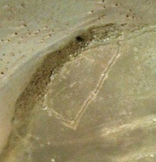
Again. "No Name" settlement
20°44'21.91"N 12° 0'15.48"W
And again, it is illogical to even consider establishing a community this size (400 + - souls) , without Adequate water to support it. This fact alone puts it into the 3000-5000BC age range. The same applies to Quadane's ancient section (Dock).
Until in situ evidence is produced, there is nothing here but fanciful speculation
Plus some basic logic and some scientific evidence that just cant be ignored (as hard as you try). The structures in the second ring, are substantial in size. 70ft to 300 ft. These, are not simple huts..... One of these structures could actually be a temple, one of many that were said to exist on the rings. It could contain, a golden statue, of Poseidon (Enki). Or, just flood rubble and junk lol.
Fanciful speculation? Or, the greatest archeological discovery of ALL TIME. Does that prospect, frighten you, Andy??
There is little doubt ocean water played a roll in the destruction of Atlantis. It just depends on how that ocean water was applied. It is open to speculation. Plato also said all entry to the area was blocked by impassable MUD. He did not say, blocked by deep ocean water. Sure would be nice for the second, missing part of the Cretaus to show up. Maybe it could clear up some points...... Unless that is, it reveals deeper secrets about those days........
The fact that Plato empathically described his Atlantis sinking into the ocean means whatever else we are discussing
Sarah Parcak, archaeologist of the University of Alabama (@indyofspace) has confirmed the rectangular structures of the Richat are ancient. 5000-8000
years.
Though she does not get into great detail about how this structure happens to be there. I suspect it was built post flood. She does not discuss the buried structure, pre flood.
"Atlas of Cursed Places S1 E2
Though she does not get into great detail about how this structure happens to be there. I suspect it was built post flood. She does not discuss the buried structure, pre flood.
"Atlas of Cursed Places S1 E2
edit on PMMondayMonday thAmerica/ChicagoAmerica/Chicago26911 by All Seeing Eye because: (no reason given)
Sarah Parcak, archaeologist of the University of Alabama (@indyofspace) states "Plato made up Atlantis. It is as real as Narnia, Mordor, Hogwarts"
twitter.com...
twitter.com...
originally posted by: AndyMayhew
Sarah Parcak, archaeologist of the University of Alabama (@indyofspace) states "Plato made up Atlantis. It is as real as Narnia, Mordor, Hogwarts"
twitter.com...
I never said she was Professional in her twit world. Heck, she called me a "Boot Licker" , and she doesn't even know me..
And I'm sure you know, I Don't lick boots lol.
But that is besides the point that she did state the rectangular fort was ancient. I could post a short video of her findings if you like.
ADDED: She is going to end up banning me lol lol lol
edit on PMTuesdayTuesday thAmerica/ChicagoAmerica/Chicago09912 by All Seeing Eye because:
(no reason given)

originally posted by: All Seeing Eye
a reply to: Degradation33
And how do you suppose that precluded people from building structures, city, on top of it? You do realize structures have been found, buried in the second ring, yes?
Structures erected within the past 2,000-3,000 years, as far as I can tell. None older.
And by the way, your dating doesn't work. They find Acheulean tools in the sediments, indicating that the collapse was far older (on the order of a million years) and at a time when h.sapiens wasn't around. The sediments in the wadis and so forth were deposited during interglacial times. Had it collapsed within the past 8,000-10,000 years, you wouldn't find sediments that old there.
The fact that the Wikipedia article doesn't indicate archaeological sites of interest in the Richat suggests that the buildings are all of fairly recent origin (past 100 years or so.)
Your "No Name" settlement (village/town) undoubtedly has a name and it's probably in Arabic on some map. I don't read Arabic, so can't help you there. But it does have all the basic characteristics of the typical Mauritanian "organic" type town growth where there's an older town center and then newer structures. There's also a lot of water around it, as the vegetation shows.
originally posted by: All Seeing Eye
Sarah Parcak, archaeologist of the University of Alabama (@indyofspace) has confirmed the rectangular structures of the Richat are ancient. 5000-8000 years.
Though she does not get into great detail about how this structure happens to be there. I suspect it was built post flood. She does not discuss the buried structure, pre flood.
"Atlas of Cursed Places S1 E2
Perhaps you could ask her what she means by "ancient." I suspect "about 1100 AD" is the answer.
originally posted by: Byrd
originally posted by: All Seeing Eye
Sarah Parcak, archaeologist of the University of Alabama (@indyofspace) has confirmed the rectangular structures of the Richat are ancient. 5000-8000 years.
Though she does not get into great detail about how this structure happens to be there. I suspect it was built post flood. She does not discuss the buried structure, pre flood.
"Atlas of Cursed Places S1 E2
Perhaps you could ask her what she means by "ancient." I suspect "about 1100 AD" is the answer.
Again, this appears to be built post flood. There are actually two of these forts in the center Island. 21° 7'23.06"N 11°22'22.11"W 21° 5'25.83"N 11°27'12.39"W A third one is also present but because of its condition may be pre or post flood. 21° 3'35.60"N 11°26'29.31"W
5000 - 8000 years. If you disagree with her conclusion, you are free to contact her.
I do hope you are not Multimedia impaired...
2 min 30 sec. In her own words.
new topics
-
This is adorable you guys!
General Chit Chat: 9 hours ago -
Reprehensible Behavior
US Political Madness: 10 hours ago -
Defending the need for adherence to Old Testament commandments under the new covenant of Christ
Conspiracies in Religions: 11 hours ago
top topics
-
Reprehensible Behavior
US Political Madness: 10 hours ago, 10 flags -
Those Drones over NJ and elsewhere
Aliens and UFOs: 15 hours ago, 8 flags -
This is adorable you guys!
General Chit Chat: 9 hours ago, 8 flags -
South Korean coup was an attempt to start WW3
World War Three: 15 hours ago, 7 flags -
Archer aviation and the NJ drones
Aircraft Projects: 16 hours ago, 5 flags -
Defending the need for adherence to Old Testament commandments under the new covenant of Christ
Conspiracies in Religions: 11 hours ago, 5 flags
active topics
-
Defending the need for adherence to Old Testament commandments under the new covenant of Christ
Conspiracies in Religions • 23 • : nugget1 -
-@TH3WH17ERABB17- -Q- ---TIME TO SHOW THE WORLD--- -Part- --44--
Dissecting Disinformation • 3710 • : hangedman13 -
George Stephanopoulos and ABC agree to pay $15 million to settle Trump defamation suit
Mainstream News • 24 • : WeMustCare -
Drones everywhere in New Jersey ---and Elsewhere Master Thread
Aliens and UFOs • 174 • : nugget1 -
The Mystery Drones and Government Lies --- Master Thread
Political Conspiracies • 106 • : cherokeetroy -
Statements of Intent from Incoming Trump Administration Members - 2025 to 2029.
2024 Elections • 45 • : WeMustCare -
Former DNI-Congressman John Ratcliffe says the U.S. Government is Intimidated by UFOs.
Aliens and UFOs • 42 • : anthelion -
Post A Funny (T&C Friendly) Pic Part IV: The LOL awakens!
General Chit Chat • 7912 • : imitator -
This is adorable you guys!
General Chit Chat • 4 • : CriticalStinker -
The Acronym Game .. Pt.4
General Chit Chat • 1016 • : FullHeathen