It looks like you're using an Ad Blocker.
Please white-list or disable AboveTopSecret.com in your ad-blocking tool.
Thank you.
Some features of ATS will be disabled while you continue to use an ad-blocker.
share:
a reply to: khnum
I don't think Cuba has much of an effect.
I think it's clobberin' time for Florida.
www.nhc.noaa.gov...
I don't think Cuba has much of an effect.
I think it's clobberin' time for Florida.
www.nhc.noaa.gov...
edit on 9/9/2017 by Phage because: (no reason given)
originally posted by: Phage
a reply to: violet
Maybe. I can't find the overlay that shows it.
Maybe MysticPearl will provide the source. Or not.
From googling around, it seems people are using the vantusky graphics and making videos on YouTube as well.
It might have been a screenshot from a video
edit on 9-9-2017 by violet because: (no reason given)
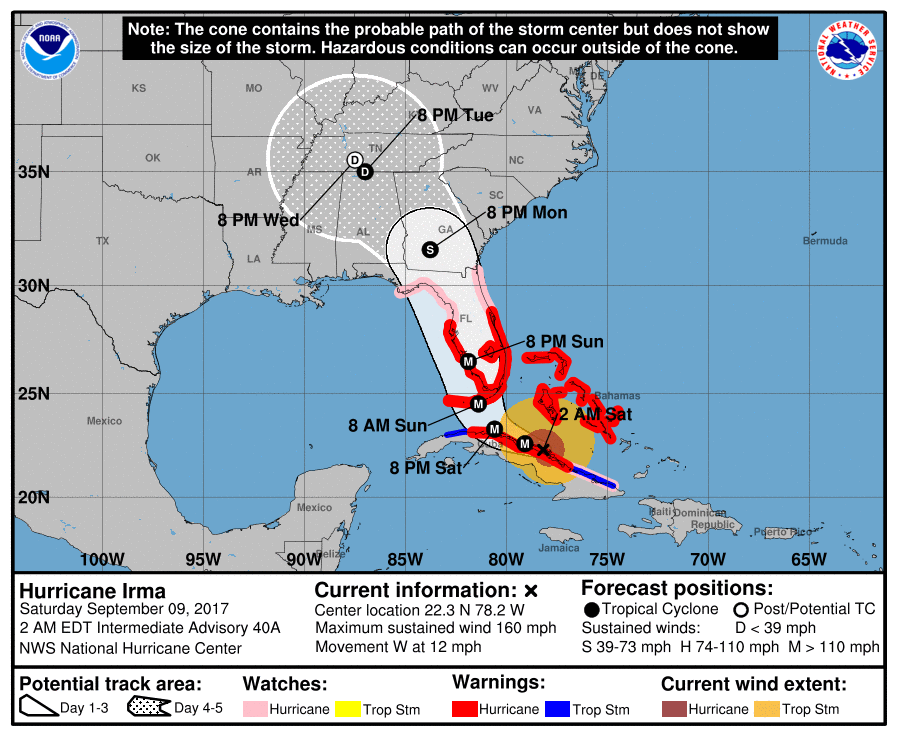
Irma Update
Still a cat 5
NHC
Still a cat 5
2:00 AM EDT Sat Sep 9
Status Category 5
Location: 22.3°N 78.2°W
Moving: W at 12 mph
Min pressure: 930 mb
Max sustained: 160 mph
EYE OF IRMA MOVING OVER THE CAMAGUEY ARCHIPELAGO OF CUBA AS A
CATEGORY 5 HURRICANE...
NHC
edit on 9-9-2017 by violet because: (no reason given)
edit on 9-9-2017 by violet
because: (no reason given)
edit on 9-9-2017 by violet because: (no reason given)
a reply to: Phage
It is losing strength because of Cuba. The 2am advisory was generous with 160mph winds in my opinion. Look for a downgrade at 5am. The pressure is rising and the storm is starting to look ragged.
Regardless, it is still a powerful storm, once it pulls away from Cuba it will have plenty of time over warm water to reorganize.
Camaguey, Cuba radar
a reply to: Phage
For sure, plenty of time.
The latest Euro computer model is out, it shows the eye going over Key West, then making landfall around Sanibel Island, riding up the coast bringing major winds to Tampa.
This is not a user friendly site, but it has good graphics forbthe various computer models:
weather.us...
a reply to: Phage
Current water temp at Key West 88.7°F.
www.ndbc.noaa.gov...
This station will be one to watch as Irma approaches.
Current water temp at Key West 88.7°F.
www.ndbc.noaa.gov...
This station will be one to watch as Irma approaches.
edit on 9-9-2017 by jrod because: D
a reply to: Phage
The Euro has been performing much better all season, and especially with Irma. The pros have noted the flaws with the GFS and the general consensus is it over estimated the short wave trough that is supposed to steer Irma north, that is why it has been east of the Euro.
The GFS also did not show a Cuba landfall, the Euro and Ukmet did.
This is discussed well on storm2k.
www.storm2k.org...
edit on 9-9-2017 by jrod because: D
new topics
-
Signing back up
Introductions: 6 hours ago
top topics
-
And Here Come the Excuses!!
General Conspiracies: 15 hours ago, 18 flags -
Another blow to Legacy Media
Propaganda Mill: 16 hours ago, 8 flags -
Drones over New Jersey
Aliens and UFOs: 15 hours ago, 8 flags -
ILLUMINATION – Reverse Perception Of Cyclic Probability – CEO ASSASSINATION
Secret Societies: 16 hours ago, 5 flags -
Signing back up
Introductions: 6 hours ago, 4 flags
active topics
-
ILLUMINATION – Reverse Perception Of Cyclic Probability – CEO ASSASSINATION
Secret Societies • 12 • : Compendium -
As dictator of health care
Medical Issues & Conspiracies • 18 • : billxam1 -
And Here Come the Excuses!!
General Conspiracies • 85 • : billxam1 -
Signing back up
Introductions • 16 • : GENERAL EYES -
music for the apocalypse
Music • 24 • : annonentity -
Rant. I am sick of people saying the police are revenue raising.
Rant • 4 • : inflaymes69 -
-@TH3WH17ERABB17- -Q- ---TIME TO SHOW THE WORLD--- -Part- --44--
Dissecting Disinformation • 3599 • : duncanagain -
Drones everywhere in New Jersey
Aliens and UFOs • 50 • : some_stupid_name -
Drones over New Jersey
Aliens and UFOs • 19 • : HatesFreshAir -
United Healthcare Shooting Suspect Nabbed in Pennsylvania
Mainstream News • 118 • : WeMustCare

