It looks like you're using an Ad Blocker.
Please white-list or disable AboveTopSecret.com in your ad-blocking tool.
Thank you.
Some features of ATS will be disabled while you continue to use an ad-blocker.
share:
a reply to: carewemust
Not really. The entire population of Florida was getting prepared the moment they first saw the models pulling East, which I knew was not going to happen.
Honestly I think more Florida citizens are prepared right now than they were in Texas, but who knows. I think something like a third of our states population has already either left or is on the road now.
This is a fantastic thread for Irma updates and real-time experiences of ATS members.
Kudos!!!!!!
I'm learning a lot, and appreciate the efforts.
The bickering about the storm and its path....I dunno.....seems to take away from the seriousness of this event.
www.wunderground.com...
Kudos!!!!!!
I'm learning a lot, and appreciate the efforts.
The bickering about the storm and its path....I dunno.....seems to take away from the seriousness of this event.
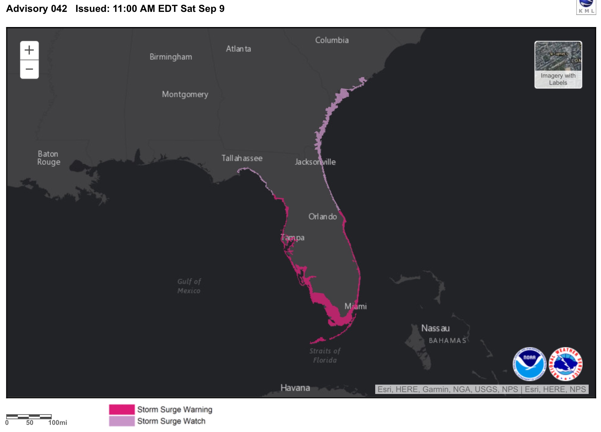
Dangerous storm surge is expected across far South Florida, including the Naples and Miami areas, the Florida Keys, and the Everglades. There is the potential for water heights of 9 or more feet above ground level in some coastal areas from Cape Coral/Fort Myers to the Everglades, as well as along parts of Biscayne Bay. The surge may be highly variable and quickly changing along and near Biscayne Bay in the Miami area. In southwest Florida, the surge may be greatest during the southwesterly onshore winds after Irma has passed just to the north.
Although NHC has not yet posted a Storm Surge Watch for the coast of northern Florida, Georgia, and southern South Carolina, the concave coastline in this area tends to concentrate storm surge, and a significant surge may occur there. This surge is likely to be less than that of Hurricane Matthew of last year, though.
Power outages will affect millions of Floridians and could last for days or weeks.
www.wunderground.com...
edit on Sat Sep 9 2017 by DontTreadOnMe because: forgot the link
a reply to: worldstarcountry
One of the things that pisses me off about the news is that they rather rehash the same old crap about hurricane speculations and having the weather man stand in the wind to sell ads, than actually help and provide live update of the evacuation routes .
Not one update have I seen about the evacuation routes from the news besides many are leaving and trafic is slow. WTF does traffic is slow mean 1 mph ,10 mph, 60 mph?
think something like a third of our states population has already either left or is on the road now.
One of the things that pisses me off about the news is that they rather rehash the same old crap about hurricane speculations and having the weather man stand in the wind to sell ads, than actually help and provide live update of the evacuation routes .
Not one update have I seen about the evacuation routes from the news besides many are leaving and trafic is slow. WTF does traffic is slow mean 1 mph ,10 mph, 60 mph?
a reply to: DontTreadOnMe
Planning is the key.
Since I live in Florida and this is not my first rodeo, I am prepared year round, as are most folk that have lived in Florida for a while, and who have been through a hurricane or two.
The problem is for the visitor, the tourist, and the newcomers. Most newcomers are taken under the wing of one of us local crusty crabs, and they will do well if they listen, some don't.
Almost every high school in South Florida is an emergency shelter. Almost every local church is a non-certified shelter. My mother's church is small, but they have two campuses. One is always used as a certified shelter, but this time they have enough paramedics and nurses as members in the church that have volunteered their time, that they are able to provide shelter for those in need, at both campuses. I will be volunteering my time after the storm has past. During the storm I am needed in my local area, as I am the only medical person out here for them to depend on, and I do people and animals.
A non-certified shelter is a shelter that is sturdy and able to withstand the force of a hurricane, based on Florida building codes and standards, but you have to bring everything that you need with you. They basically just provide a safe building. There are no emergency stores, foods, beds, cots, or other items.
Evacuate means to leave an area that is unsafe for an area that is safer. You don't need to leave the State to evacuate to a place of safety.
a reply to: namehere
Special Needs Shelter Information
Im not really certain you will be able to have that forum submitted in time, but there are phone numbers as well. If you are west of Race Track Road you are in Pinellas county though, so this bulletin would not apply if that were the case. Hopefully your east.
If you are in Forida and want to volunteer your efforts and resources, visit Volunteer Florida for details on what and how you can assist. Working together we will all do well.
Special Needs Shelter Information
In order to be admitted to a special needs shelter you will need to complete an ev aluation form prior to an emergency and meet certain eligibility requirements. Once you have completed the evaluation form, you will be contacted for more information and your medical needs and eligibility will be assessed. If you are eligible to be admitted to a special needs shelter you will be assigned to one of three shelters. If you do not qualify for a special needs shelter, other options will be discussed with you.
To register for a special needs shelter and/or transportation, select one of the following options:
Call the Hillsborough County Health Department at 813-307-8063
Call your home health care provider
Complete an evaluation form (English form and Spanish form) and mail or fax to:
Hillsborough County Health Department
P.O. Box 5135
Tampa, FL 33675-5135
Im not really certain you will be able to have that forum submitted in time, but there are phone numbers as well. If you are west of Race Track Road you are in Pinellas county though, so this bulletin would not apply if that were the case. Hopefully your east.
Mandatory Evacuation for Zone A Ahead of Hurricane Irma
Hillsborough County has issued a mandatory evacuation for Evacuation Zone A starting at 8 a.m. today. The County has opened 16 shelters for residents in Evacuation Zone A, and whose homes are vulnerable to storm surge and flooding, and for manufactured homes that are susceptible to wind damage.
Below is the list of shelters now open to residents:
Middleton High School, 4801 N 22nd Street in Tampa
Simmons Career Center, 1202 W Grant Street in Plant City
Shields Middle School, 15732 Beth Shields Ways in Ruskin (Pet-Friendly) - FULL
Pizzo Elementary School, 11701 Bull Run in Tampa
Cypress Creek Elementary School, 400 19th Ave NE in Ruskin
Hammond Elementary School, 8008 N Mobley Road in Odessa
Sessums Elementary School, 11525 Ramble Creek Drive in Tampa
Bartels Middle School, 9020 Imperial Oak Blvd in Tampa (Pet-Friendly)
Brandon High School, 1101 Victoria Street in Brandon
Smith, Sgt. Paul Middle School, 14303 Citrus Pointe Drive in Tampa (Pet-Friendly)
Burnett Middle School, 1010 N Kingsway Road in Seffner (Pet-Friendly)
Valrico Elementary School, 609 South Miller Road in Valrico
Summerfield Crossings Elementary School, 11050 Fairway Meadow Road in Valrico
Greco Middle School, 6925 East Fowler Ave in Temple Terrace
Strawberry Crest High School, 4691 Gallagher Road in Dover (Special Needs Only)
SunDome at USF, 4202 E. Fowler Ave. in Tampa (Special Needs Only)
The special-needs shelters are only for residents with medical issues that require electricity assistance or cognitive issues that would not be supported in a general population shelter.
Residents bringing pets to one of the four pet-friendly shelters need to bring a sturdy carrier for each pet that allows room for the pet to stand up and move around, as well as a collar with a leash and supplies for each pet to last seven days. More information on how residents can prepare their pets can be found here - Pet Disaster Planning.
Residents can confirm evacuation zones and register for HCFL Alert, Hillsborough County's official public notification system, at HCFLGov.net/StaySafe or by calling (813) 272-5900.
If you are in Forida and want to volunteer your efforts and resources, visit Volunteer Florida for details on what and how you can assist. Working together we will all do well.
edit on 9-9-2017 by worldstarcountry because: (no reason
given)
originally posted by: violet
In that video on page 5 ( no hype one) I think it said it would skirt Cuba, a direct hit was uncertain. I'm on pause watching it. Very long video, but good.
Well, it's official, we would've been stuck in Havana. All flights were canceled with the soonest leaving possibly on Monday. We spoke with the people who we were going to rent from and they have no power and the city is getting pounded. In retrospect it's a good thing we cancelled when we did.
edit on 9-9-2017 by AugustusMasonicus because: Ph'nglui mglw'nafh Cthulhu R'lyeh wgah'nagl fhtagn
A new advisory is out, she has weakened considerably, but still a major hurricane. When the storm pulls away from Cuba there it will strengthen again,
possibly rapidly since it will be going over 88° water in the Keys.
11:00 AM EDT Sat Sep 9
Location: 22.8°N 79.8°W
Moving: W at 9 mph
Min pressure: 941 mb
Max sustained: 125 mph
The discussion:
www.nhc.noaa.gov
11:00 AM EDT Sat Sep 9
Location: 22.8°N 79.8°W
Moving: W at 9 mph
Min pressure: 941 mb
Max sustained: 125 mph
The discussion:
Hurricane Irma Discussion Number 42
NWS National Hurricane Center Miami FL AL112017
1100 AM EDT Sat Sep 09 2017
The interaction of Irma's circulation with Cuba has resulted in some weakening of the hurricane. Data from an Air Force plane indicate that the maximum winds are now 110 kt. However, once the circulation moves away from Cuba, restrengthening is forecast and Irma is expected to remain a very dangerous hurricane for the next 2 days while moving very near the Florida peninsula.
The eye has been moving toward the west or 280 degrees at about 8 kt. The hurricane is about the reach the southwestern portion of the subtropical high, and the expected turn to the northwest and north-northwest should begin soon. The track guidance is tightly packed and takes the hurricane over the Florida Keys and near or over the Florida Peninsula. The NHC forecast is in the middle of the guidance envelope and given the good agreement among models, the confidence in the track forecast is high.
Irma is now under the scope of Key West radar, so hourly updates will begin at 1600 UTC.
KEY MESSAGES:
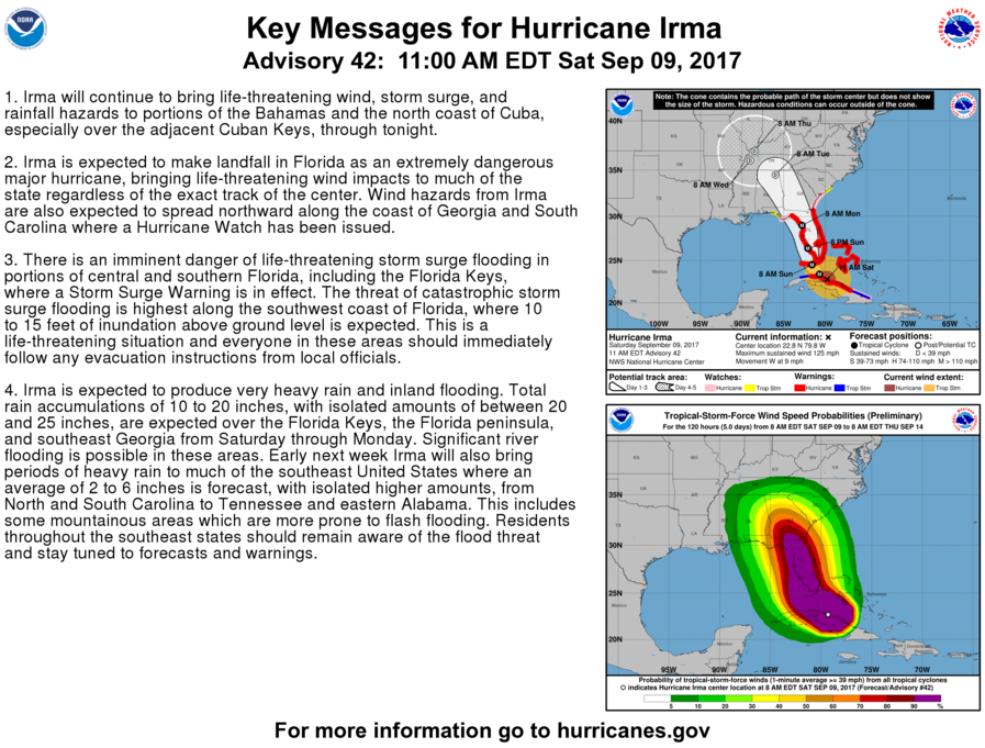
1. Irma will continue to bring life-threatening wind, storm surge, and rainfall hazards to portions of the Bahamas and the north coast of Cuba, especially over the adjacent Cuban Keys, through tonight.
2. Irma is expected to make landfall in Florida as an extremely dangerous major hurricane, bringing life-threatening wind impacts to much of the state regardless of the exact track of the center. Wind hazards from Irma are also expected to spread northward along the coast of Georgia and South Carolina where a Hurricane Watch has been issued.
3. There is an imminent danger of life-threatening storm surge flooding in portions of central and southern Florida, including the Florida Keys, where a Storm Surge Warning is in effect. The threat of catastrophic storm surge flooding is highest along the southwest coast of Florida, where 10 to 15 feet of inundation above ground level is expected. This is a life-threatening situation and everyone in these areas should immediately follow any evacuation instructions
from local officials.
4. Irma is expected to produce very heavy rain and inland flooding.Total rain accumulations of 10 to 20 inches, with isolated amounts of between 20 and 25 inches, are expected over the Florida Keys, the Florida peninsula, and southeast Georgia from Saturday through Monday. Significant river flooding is possible in these areas. Early next week Irma will also bring periods of heavy rain to much of the southeast United States where an average of 2 to 6 inches is forecast, with isolated higher amounts, from North and South Carolina to Tennessee and eastern Alabama. This includes some mountainous areas which are more prone to flash flooding. Residents throughout the southeast states should remain aware of the flood threat and stay tuned to forecasts and warnings.
www.nhc.noaa.gov
FWIW , I live in naples and despite the Freakin news not reporting on the evacuation route you can use google maps to see the traffic .
www.drivingdirectionsandmaps.com...
It appears that I75 and I95 are clear . Friends left to Orlando and had no problems with traffic.
Another reason why the NEWS dont give F or actually wants to help, instead of showing the stupid weather man telling you are going to die and showing trailier parks blowing away they should be giving live update of the evacuation routes with the storm path.
All they keep reporting is that many are evacutting which makes people think they are going to be in a stand still when the strom hits.
Right now its clear and some could leave that don't have shelter.
Here is another good source to follow the Hurricane.
weather.com...
edit on 42930America/ChicagoSat, 09 Sep 2017 10:42:39 -0500000000p3042 by
interupt42 because: (no reason given)
a reply to: KnoxMSP
Getting a band or two here also. It was eerily quiet when I went outside to make sure there wasn't any debris that found its way into my yard over the night. As I walked around giving my trees a pep talk, a few frogs started singing. I told them they had the right idea. I started singing and I was surprised when the birds joined in. I know it was just coincidence, but I thought it was funny. I stopped singing and it got quiet again. They may have been trying to tell me something, like don't quit my day job.
I am sure that I have confirmed for some that I am indeed a bit strange. I talk to the trees, the birds, the reptiles, the fish, the animals, and I will talk to everything and everybody, that is just the way I am. My mother says I have been that way my entire life. She says I take after my half Irish, half Jewish, great grandfather, and inherited his gift of gab. Seems it is in the genes.
a reply to: NightSkyeB4Dawn
There is nothing strange about that. Humans used to be able to communicate quite effectively with all life on Earth. Our downward spiral of ignorance and superiority over the last couple thousand years however is making us forget we can do so. Humans are happiest when in harmony with nature, and communication with animals comes with it.
There is nothing strange about that. Humans used to be able to communicate quite effectively with all life on Earth. Our downward spiral of ignorance and superiority over the last couple thousand years however is making us forget we can do so. Humans are happiest when in harmony with nature, and communication with animals comes with it.
Saw a whole bunch of ducks flying west, man were they loud. You never see ducks flying this way.
I was just viewing a lot of the live street cams in and around Key West, there is still a lot of people moving around.
I don't what to think about it anymore.
I don't what to think about it anymore.
originally posted by: flatbush71
I was just viewing a lot of the live street cams in and around Key West, there is still a lot of people moving around.
I don't what to think about it anymore.
For those that believe in a God, pray for them because nature is unkind, and the raw power of these storms should not be underestimated.....Andrew in '92 is all anyone that is / used to be from South Dade should need to remind themselves of that fact.
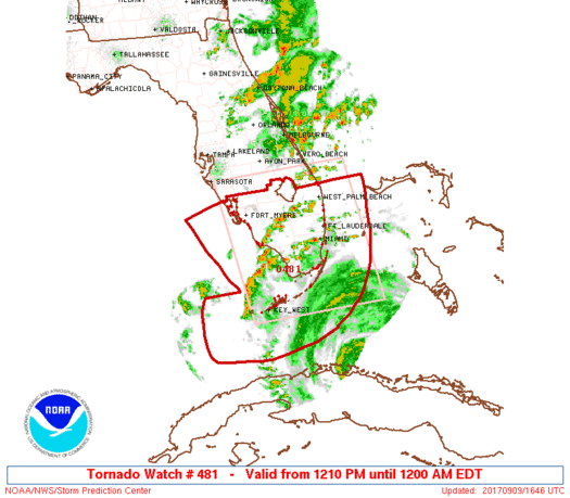
Tornado warnings in Florida being reported by Jeff Piotrowski. He has been on his way from South Beach towards Marco Island.
Reporting via Periscope live stream
Reporting via Periscope live stream
originally posted by: Diabolical1972
Saw a whole bunch of ducks flying west, man were they loud. You never see ducks flying this way.
Maybe they were geese? They're loud! Maybe migrating out of the way I guess. Usually if they are feeling cooler temps, although I'm not a expert on our feathered friends
edit on 9-9-2017 by violet because: (no reason given)
MOTICE! Storm surge could be as high as 15ft in coastal southwest FLA. That's over a first story house or covering a one floor house.
If you haven't yet left the only time to do so is after this first band of rain as passed by before the really bad stuff moves in. Still risky though but if the water gets that high it would be deadly

NHC
If you haven't yet left the only time to do so is after this first band of rain as passed by before the really bad stuff moves in. Still risky though but if the water gets that high it would be deadly

NHC
edit on 9-9-2017 by violet because: (no reason given)
new topics
-
OK this is sad but very strange stuff
Paranormal Studies: 44 minutes ago -
Islam And A Book Of Lies
Religion, Faith, And Theology: 1 hours ago -
Sorry to disappoint you but...
US Political Madness: 4 hours ago -
Watch as a 12 million years old Crab Emerges from a Rock
Ancient & Lost Civilizations: 9 hours ago
top topics
-
Sorry to disappoint you but...
US Political Madness: 4 hours ago, 13 flags -
Speaking of Pandemics
General Conspiracies: 17 hours ago, 10 flags -
Just Sick of It! Done! Can't take it anymore!
General Chit Chat: 16 hours ago, 9 flags -
ILLUMINATION: Dimensions / Degrees – Da Vincis Last Supper And The Philosophers Stone
Secret Societies: 15 hours ago, 9 flags -
Watch as a 12 million years old Crab Emerges from a Rock
Ancient & Lost Civilizations: 9 hours ago, 9 flags -
OK this is sad but very strange stuff
Paranormal Studies: 44 minutes ago, 3 flags -
Islam And A Book Of Lies
Religion, Faith, And Theology: 1 hours ago, 1 flags
active topics
-
Stuck Farmer And His Queue Jumping Spawn
Rant • 5 • : rickymouse -
Speaking of Pandemics
General Conspiracies • 4 • : rickymouse -
Meta Llama local AI system is scary good
Science & Technology • 37 • : glend -
Sorry to disappoint you but...
US Political Madness • 12 • : Vermilion -
OK this is sad but very strange stuff
Paranormal Studies • 0 • : Ravenwatcher -
Trump's idea to make Canada the 51st US state: 'Potential is massive'
Mainstream News • 154 • : WeMustCare -
DONALD J. TRUMP - TIME's Most Extraordinary Person of the Year 2024.
Mainstream News • 62 • : WeMustCare -
Islam And A Book Of Lies
Religion, Faith, And Theology • 2 • : charlest2 -
Biden to award Presidential Citizens Medal to Liz Cheney and Bennie Thompson
US Political Madness • 18 • : WeMustCare -
Joe Biden gives the USA's Highest Civilian Honor Award to Hillary Clinton and George Soros.
US Political Madness • 45 • : WeMustCare


