It looks like you're using an Ad Blocker.
Please white-list or disable AboveTopSecret.com in your ad-blocking tool.
Thank you.
Some features of ATS will be disabled while you continue to use an ad-blocker.
share:
reply to post by muzzy
THX THX.
Hmmmm . . . Welll, if you must be a Master Quake Jockey in all that rockin' and rollin' down under,
PLEASE ride on the tops of them and NOT UNDER them!
SUBJECTIVELY . . . has it seemed like things have picked up a tick or 3 in your region?
THX THX.
Hmmmm . . . Welll, if you must be a Master Quake Jockey in all that rockin' and rollin' down under,
PLEASE ride on the tops of them and NOT UNDER them!
SUBJECTIVELY . . . has it seemed like things have picked up a tick or 3 in your region?
muzzy
reply to post by Trillium
6.9 you say?
No you didn't.
6.5 according to GFZ
geofon.gfz-potsdam.de...
OOOOP
Miss it by that much
By it was inside the link
reply to post by BO XIAN
Seemed like it was, but it has died away again.
I'm not sure about April, we have had radiated energy release figures below 7 nowthree four times and no M5+.
graph here
Either Muzzy's Rule has passed its use-by-date, or the 5+ when it comes is going to be a doozey.
I'm still picking Fiordland or further South, keeping an eye on LDEO for Pacific-Antarctic movement, that is usually an early indicator, but not always. That Bouvet Island Region 6.5 is on the edge of the Antarctic Plate, but its on the other size from us.
Siesmic Hot spots move around over time, seems the central area of NZ has taken the heat for a while since Canterbury in Dec 2011, with 4 mag 6's since in the Lower North island
Even the Kermadec Islands are quiet, too quiet for my liking.....
Seemed like it was, but it has died away again.
I'm not sure about April, we have had radiated energy release figures below 7 now
Either Muzzy's Rule has passed its use-by-date, or the 5+ when it comes is going to be a doozey.
I'm still picking Fiordland or further South, keeping an eye on LDEO for Pacific-Antarctic movement, that is usually an early indicator, but not always. That Bouvet Island Region 6.5 is on the edge of the Antarctic Plate, but its on the other size from us.
edit on 0400000010410414 by muzzy because: (no reason given)
Siesmic Hot spots move around over time, seems the central area of NZ has taken the heat for a while since Canterbury in Dec 2011, with 4 mag 6's since in the Lower North island
edit on 0400000010410414 by muzzy because: (no reason given)
Even the Kermadec Islands are quiet, too quiet for my liking.....
edit on 04u10410414 by muzzy because: just downloaded the NZ data for the
last two days and another low day of TTNTER on the 14th of 5, so that makes it four times instead of three this month.
reply to post by Trillium
yeah I kow it was, thats why I mentioned it, but you didn't put the magnitude in your post.
Maybe I should have just said "you didn't put the magnitude in your post" ......
yeah I kow it was, thats why I mentioned it, but you didn't put the magnitude in your post.
Maybe I should have just said "you didn't put the magnitude in your post" ......
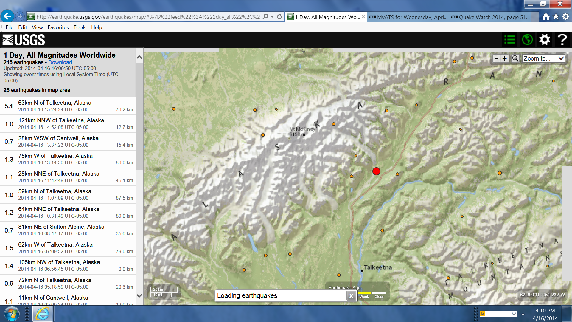
M 5.1 - 63km N of Talkeetna, Alaska
PAGER - GREENShakeMap - IVDYFI? - VTsunami Warning Center
Time2014-04-16 15:24:24 UTC-05:00Location62.886°N 149.935°WDepth76.2km

PAGER - GREENShakeMap - IVDYFI? - VTsunami Warning Center
Time2014-04-16 15:24:24 UTC-05:00Location62.886°N 149.935°WDepth76.2km

edit on 16-4-2014 by SeekingDepth because: (no reason given)
SeekingDepth
M 5.1 - 63km N of Talkeetna, Alaska
PAGER - GREENShakeMap - IVDYFI? - VTsunami Warning Center
Time2014-04-16 15:24:24 UTC-05:00Location62.886°N 149.935°WDepth76.2km
Just checking this thread real quick to see if you guys noticed that one.
Possible foreshock? Or just a standard AK quake?
edit on 16-4-2014 by GoShredAK because: Edit
reply to post by GoShredAK
For a second I thought I was having a dizzy spell!
I think it's just a routine quake.
For a second I thought I was having a dizzy spell!
I think it's just a routine quake.
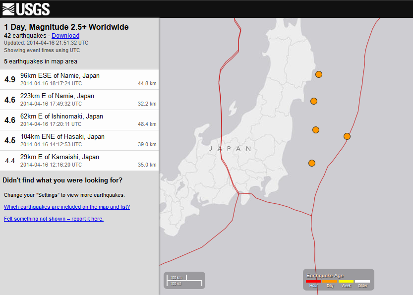
The placement of these on the map and their depths are interesting:

What do our knowledgeable members think of it? Just normal random placements, or something to keep an eye on?

What do our knowledgeable members think of it? Just normal random placements, or something to keep an eye on?
edit on 4/16/2014 by Nyiah
because: (no reason given)
reply to post by Nyiah
Same struck me earlier today, but I think it is just normal quakes.
You have a lot of those in this region, they just seem to line up by accident
Same struck me earlier today, but I think it is just normal quakes.
You have a lot of those in this region, they just seem to line up by accident
reply to post by GoShredAK
I guess we will find out soon enough huh!
That's bigger than the usual in that area.
Not unusual though,
just bigger than lately.
*eyeballs Alaska*
I guess we will find out soon enough huh!
That's bigger than the usual in that area.
Not unusual though,
just bigger than lately.
*eyeballs Alaska*
Magnitude 6.2 - Balleny Islands Region (702)
Location in Google Maps
- Date-Time: Thursday, April 17, 2014 @ 15:06:51 UTC
- Earthquake location: 62.857°S, 155.626°E,
- Earthquake depth: 17.5 km
- Distances:
511km (317mi) NW of Young Island,
1999km (1242mi) SSW of Invercargill, New Zealand
2045km (1270mi) SSW of Gore, New Zealand
2111km (1311mi) SSW of Dunedin, New Zealand
2287km (1421mi) S of Hobart, Australia
- Event ID: usb000pnw2
Derived from Event Data Source: USGS
Powered by QVSData
Bouvet and now Balleny. The bottom is falling off!!!!
reply to post by PuterMan
not falling off ............ rotating
2014/4/17 13:10:8.0 -55.25 -129.25 33.0 5.7 PACIFIC-ANTARCTIC RIDGE
www.ldeo.columbia.edu...
with those two I expect NZ will get an uptick if not a M5+ of its own pretty soon (haven't had any for April yet)
and a 5.2 aftershock of your one 2014/04/17 15:11:01
earthquake.usgs.gov...
not falling off ............ rotating
2014/4/17 13:10:8.0 -55.25 -129.25 33.0 5.7 PACIFIC-ANTARCTIC RIDGE
www.ldeo.columbia.edu...
with those two I expect NZ will get an uptick if not a M5+ of its own pretty soon (haven't had any for April yet)
edit on 04u10610614 by muzzy because: add link
and a 5.2 aftershock of your one 2014/04/17 15:11:01
earthquake.usgs.gov...
edit on 04u10610614 by muzzy because: and another
edit on
04u10610614 by muzzy because: yawns and goes back to sleep
F-E Region: Santa Cruz Islands Region
Time: 2014-04-18 04:13:12.5 UTC
Magnitude: 6.0
Epicenter: 164.70°E 11.09°S
Depth: 10 km
Status: A - automatic
geofon.gfz-potsdam.de...
I notice a fe wchanges to the ATS post layout, popup preview instead of below the post editor,
don't like it
a reply to: muzzy
F-E Region: Santa Cruz Islands Region
Time: 2014-04-18 04:13:12.6 UTC
Magnitude: 6.1 (Mw)
Epicenter: 164.70°E 11.10°S
Depth: 10 km
Status: C - confirmed
and an aftershock
F-E Region: Santa Cruz Islands Region
Time: 2014-04-18 07:30:14.7 UTC
Magnitude: 5.2
Epicenter: 164.75°E 11.12°S
Depth: 10 km
Status: A - automatic
F-E Region: Santa Cruz Islands Region
Time: 2014-04-18 04:13:12.6 UTC
Magnitude: 6.1 (Mw)
Epicenter: 164.70°E 11.10°S
Depth: 10 km
Status: C - confirmed
edit on 04u10710714 by muzzy because: (no reason given)
and an aftershock
F-E Region: Santa Cruz Islands Region
Time: 2014-04-18 07:30:14.7 UTC
Magnitude: 5.2
Epicenter: 164.75°E 11.12°S
Depth: 10 km
Status: A - automatic
edit on 0400000010710714 by muzzy because: (no reason given)
Minutes ago we got a very high quake in Mexico City.
It was over 7.5 to 8
At this time there is no info
It was over 7.5 to 8
At this time there is no info
NVM--I see Puters is on it!
ETA:
GFZ Potsdam has an automatic of Mag 7.1.
USGS has a manual of Mag 7.5 Mi. (not familiar with Mi?)
edit on 4/18/2014 by Olivine because: (no reason given)
ETA:
GFZ Potsdam has an automatic of Mag 7.1.
USGS has a manual of Mag 7.5 Mi. (not familiar with Mi?)
edit on 4/18/2014 by Olivine because: add data
M 7.5 - 39km E of Petatlan, Mexico
Time
2014-04-18 14:27:29 UTC
Location
17.554°N 100.895°W
Depth
51.8km
edit on 4/18/2014 by Olivine because: (no reason given)
a reply to: Olivine
USGS joined the party from the pt network
Location in Google Maps
Derived from Event Data Source: USGS
Powered by QVSData
Not on US net yet.
USGS joined the party from the pt network
Magnitude 7.5 - Guerrero. Mexico (59)
Location in Google Maps
- Date-Time: Friday, April 18, 2014 @ 14:27:29 UTC
- Earthquake location: 17.554°N, 100.895°W,
- Earthquake depth: 51.8 km
- Distances:
39km (24mi) E of Petatlan, Mexico
40km (24mi) NNW of Tecpan de Galeana, Mexico
62km (38mi) NW of Atoyac de Alvarez, Mexico
70km (43mi) E of Zihuatanejo, Mexico
279km (173mi) SW of Mexico City, Mexico
- Event ID: pt14108001
Derived from Event Data Source: USGS
Powered by QVSData
Not on US net yet.
new topics
-
Prisoner CNN helped free from Syrian prison was actually notorious Assad regime torturer: report
Mainstream News: 13 minutes ago -
Labour Plotting to Postpone May's Council Elections ?
Regional Politics: 1 hours ago -
Is this really what is going on?
General Conspiracies: 2 hours ago -
Russias War Against Religion in Ukraine
World War Three: 2 hours ago -
iPhone Microphone Being Accessed by Unknown App
The Gray Area: 5 hours ago -
Democrats send letter to Biden urging him to ratify Equal Rights Amendment
US Political Madness: 11 hours ago
top topics
-
iPhone Microphone Being Accessed by Unknown App
The Gray Area: 5 hours ago, 10 flags -
Is this really what is going on?
General Conspiracies: 2 hours ago, 7 flags -
Democrats send letter to Biden urging him to ratify Equal Rights Amendment
US Political Madness: 11 hours ago, 4 flags -
Russias War Against Religion in Ukraine
World War Three: 2 hours ago, 4 flags -
Labour Plotting to Postpone May's Council Elections ?
Regional Politics: 1 hours ago, 2 flags -
Prisoner CNN helped free from Syrian prison was actually notorious Assad regime torturer: report
Mainstream News: 13 minutes ago, 2 flags
active topics
-
Is this really what is going on?
General Conspiracies • 14 • : LSU2018 -
The Mystery Drones and Government Lies --- Master Thread
Political Conspiracies • 117 • : Guyfriday -
Drones everywhere in New Jersey ---and Elsewhere Master Thread
Aliens and UFOs • 181 • : matafuchs -
Prisoner CNN helped free from Syrian prison was actually notorious Assad regime torturer: report
Mainstream News • 0 • : xuenchen -
Russias War Against Religion in Ukraine
World War Three • 7 • : FlyersFan -
More Bad News for Labour and Rachel Reeves Stole Christmas from Working Families
Regional Politics • 10 • : Bilbous72 -
Labour Plotting to Postpone May's Council Elections ?
Regional Politics • 1 • : gortex -
Democrats send letter to Biden urging him to ratify Equal Rights Amendment
US Political Madness • 9 • : Texastruth2 -
Damascus has Fallen - Syrians are inside the presidential palace
Mainstream News • 106 • : Oldcarpy2 -
Post A Funny (T&C Friendly) Pic Part IV: The LOL awakens!
General Chit Chat • 7916 • : KrustyKrab
