It looks like you're using an Ad Blocker.
Please white-list or disable AboveTopSecret.com in your ad-blocking tool.
Thank you.
Some features of ATS will be disabled while you continue to use an ad-blocker.
share:
update to post by PuterMan
It was indeed a mine blast ML=3.7
This means that EMSC and GFZ are in fact in error. These may get removed now I have woken the baby.
If I am given permission I will post the full email reply. It appears that larger blasts can take up to 6 weeks to appear.
For future reference, if anyone needs them, I am now download the mining list and the mining phases list daily along with all the other PDE lists and seismograms (Cascades and Bayou Corne) that I download every day.
reply to post by PuterMan
GFZ at 4.4, LDEO at 4.7Ms
that one heck of a kaboom , considering the Korean Nuclear test was 4.7/4.8
GFZ at 4.4, LDEO at 4.7Ms
that one heck of a kaboom , considering the Korean Nuclear test was 4.7/4.8
Edit: Long time lurker, first time poster..
Magnitude: 6.7
DateTime: Wednesday January 30 2013, 20:15:41 UTC
Region: Atacama, Chile
Magnitude: 6.7
DateTime: Wednesday January 30 2013, 20:15:41 UTC
Region: Atacama, Chile
edit on 30-1-2013 by buckshot44 because: Intro
2013-01-30 20:15:39.024min ago 28.05 S 70.65 W 2 6.8 ATACAMA, CHILE
Magnitude Mw 6.8
Region ATACAMA, CHILE
Date time 2013-01-30 20:15:39.0 UTC
Location 28.05 S ; 70.65 W
Depth 30 km
Distances 602 km NW Santiago (pop 4,837,295 ; local time 16:15:39.2 2013-01-30)
83 km S Copiapó (pop 129,280 ; local time 16:15:39.2 2013-01-30)
59 km N Vallenar (pop 44,895 ; local time 16:15:39.2 2013-01-30)
www.emsc-csem.org...
earthquake.usgs.gov...
reply to post by buckshot44
Welcome to ATS.... glad you finally made an account. Stay around... it gets more and more interesting.
Are you interested in Earthquakes? I am assuming the answer is yes.
Welcome to ATS.... glad you finally made an account. Stay around... it gets more and more interesting.
Are you interested in Earthquakes? I am assuming the answer is yes.
reply to post by MamaJ
Yes, I am very interested in Earthquakes, among other topics covered here at ATS. I've been lurking for about 2 years.
I live on the West Coast of Canada, about an hours drive from Vancouver in the Fraser Valley.
Yes, I am very interested in Earthquakes, among other topics covered here at ATS. I've been lurking for about 2 years.
I live on the West Coast of Canada, about an hours drive from Vancouver in the Fraser Valley.
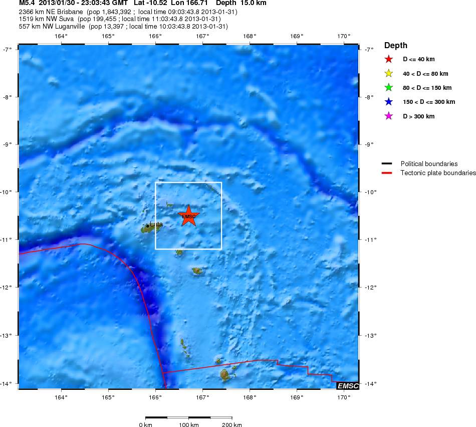
2013-01-30 23:03:43.013min ago 10.52 S 166.71 E 15 6.0 SANTA CRUZ ISLANDS
Magnitude M 6.0
Region SANTA CRUZ ISLANDS
Date time 2013-01-30 23:03:43.0 UTC
Location 10.52 S ; 166.71 E
Depth 10 km
Distances 2366 km NE Brisbane (pop 1,843,392 ; local time 09:03:43.8 2013-01-31)
1519 km NW Suva (pop 199,455 ; local time 11:03:43.8 2013-01-31)
557 km NW Luganville (pop 13,397 ; local time 10:03:43.8 2013-01-31)
98 km E Lata (pop 538 ; local time 10:03:43.8 2013-01-31)
www.emsc-csem.org... ; earthquake.usgs.gov...
www.abovetopsecret.com...

edit on 30-1-2013 by MariaLida because: (no reason given)
reply to post by MariaLida
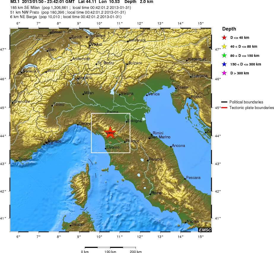
2013-01-30 23:42:01.20 5min ago 44.11 N 10.53 E 7 3.3 NORTHERN ITALY
www.emsc-csem.org...#

2013-01-30 23:42:01.20 5min ago 44.11 N 10.53 E 7 3.3 NORTHERN ITALY
www.emsc-csem.org...#

edit on 30-1-2013 by MariaLida because: (no reason given)
Already posted, but why today?
3 days after Full Moon
2013-01-30 23:03:45 6.0 10.67°S 166.54°E 10 A Santa Cruz Islands
2013-01-30 20:15:45 6.7 28.05°S 70.70°W 47 M Central Chile
on the Full Moon though
2013-01-28 16:38:55 6.1 42.59°N 79.76°E 18 M MT Lake Issyk Kul Region
source GFZ
3 days after Full Moon
2013-01-30 23:03:45 6.0 10.67°S 166.54°E 10 A Santa Cruz Islands
2013-01-30 20:15:45 6.7 28.05°S 70.70°W 47 M Central Chile
on the Full Moon though
2013-01-28 16:38:55 6.1 42.59°N 79.76°E 18 M MT Lake Issyk Kul Region
source GFZ
edit on 30-1-2013 by muzzy because: mark 'em red
reply to post by MariaLida
that 3.3 was a long time coming eh
I didn't count that one offshore you posted the other day was 200km away from the 4.8.
that 3.3 was a long time coming eh
I didn't count that one offshore you posted the other day was 200km away from the 4.8.
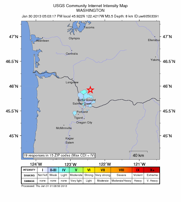
Magnitude 3.7
Date-Time
Thursday, January 31, 2013 at 01:03:17 UTC
Wednesday, January 30, 2013 at 05:03:17 PM at epicenter
Location 45.922°N, 122.422°W
Depth 8.9 km (5.5 miles)
Region WASHINGTON
Distances
4 km (2 miles) ENE (58°) from Amboy, WA
6 km (4 miles) N (350°) from Yacolt, WA
15 km (9 miles) NNE (32°) from Lewisville, WA
35 km (22 miles) NNE (24°) from Vancouver, WA
earthquake.usgs.gov...

edit on 30-1-2013 by MariaLida because: (no reason given)
Any pros logged on at the moment to take a look at the Yellowstone seismos....
www.isthisthingon.org...
Seems I have seen these type of signatures before, but could not remember if they were mechanical of not.
www.isthisthingon.org...
Seems I have seen these type of signatures before, but could not remember if they were mechanical of not.
reply to post by radpetey
Pro is a stretch,.. by a long shot
But could be alot of things not related to deep underground.
But could be alot of things not related to deep underground.
Originally posted by Lil Drummerboy
reply to post by radpetey
Pro is a stretch,.. by a long shot
But could be alot of things not related to deep underground.
No poo pooing allowed
2nd
Originally posted by muzzy
Already posted, but why today?
3 days after Full Moon
2013-01-30 23:03:45 6.0 10.67°S 166.54°E 10 A Santa Cruz Islands
2013-01-30 20:15:45 6.7 28.05°S 70.70°W 47 M Central Chile
on the Full Moon though
2013-01-28 16:38:55 6.1 42.59°N 79.76°E 18 M MT Lake Issyk Kul Region
source GFZedit on 30-1-2013 by muzzy because: mark 'em red
add a couple more
2013-01-31 03:33:44 6.2 10.58°S 166.41°E 10 A Santa Cruz Islands
2013-01-31 03:57:57 5.9 10.70°S 166.62°E 10 A Santa Cruz Islands
just waiting for LISS to tick over, nothing showing since 3:30UTC, so those 2 later ones aren't showing yet.
If correct the LISS graphs are going to be a mess.
sometimes the best LISS graph to watch is an isolated one, I'm going to watch this one, its the clearest (cleanest). You can clearly see the Chile and the Santa Cruz 6's as seperate wiggles.
KNTN (Kanton Island, Kiribati)
edit on 30-1-2013 by muzzy because: add this
according to this the P wave is still 5 minutes away (as I write @ 4:35UTC)
edit on 30-1-2013 by muzzy because: another big one
2013-01-31 04:31:31 5.7 10.94°S 165.42°E 10 A Santa Cruz Islands
source for events posted above Geofon-GFZ, they are giving the best coverage on Santa Cruz right now.
This is where Live Earthquake Mashup comes into its own, flick between GFZ, EMSC and USGS
un-tick the "follow" box to stay on the spot, new quakes will come up as they happen.
edit on 30-1-2013 by muzzy because: alteration by GFZ
that last one downgraded 0.1 mag, and moved (still an automatic reading)
2013-01-31 04:31:30 5.6 10.90°S 165.53°E 10 A Santa Cruz Islands
edit on 30-1-2013 by muzzy because: (no reason given)
The 2nd mag 6 now showing on KNTN (Kanton Island, Kiribati
I grabbed a screenshot of that, just in case there is a mag 7, that would obliterate the graph into blackness.
Latest adjustments and two more on GFZ
30/01/2013 23:03 6.0 10.62°S 166.41°E 10 M Santa Cruz Islands
31/01/2013 3:33 6.2 10.58°S 166.41°E 10 C Santa Cruz Islands
31/01/2013 3:57 5.7 10.70°S 166.52°E 10 M Santa Cruz Islands
31/01/2013 4:31 5.6 10.90°S 165.53°E 10 A Santa Cruz Islands
31/01/2013 5:18 5.3 10.58°S 166.54°E 10 A Santa Cruz Islands
31/01/2013 6:42 5.2 10.85°S 166.59°E 10 A Santa Cruz Islands
yeah I think KNTN is still the best representation on LISS, the signals are not as big as some other stations but you can define the individual quakes, they are all in proportion to the magnitudes mentioned.

edit on 31-1-2013 by muzzy because: (no reason given)
USGS catching up now and some lower mags too
6.0 30/01/2013 23:03 -10.518 166.486 10 SANTA CRUZ ISLANDS
4.6 30/01/2013 23:53 -10.565 166.438 15 SANTA CRUZ ISLANDS
6.2 31/01/2013 3:33 -10.628 166.382 9.2 SANTA CRUZ ISLANDS
5.6 31/01/2013 3:58 -10.68 166.391 35.1 SANTA CRUZ ISLANDS
5.6 31/01/2013 4:31 -10.934 165.418 32.9 SANTA CRUZ ISLANDS
5.0 31/01/2013 5:16 -10.502 166.201 25 SANTA CRUZ ISLANDS
5.4 31/01/2013 5:18 -10.567 166.446 45.7 SANTA CRUZ ISLANDS
5.1 31/01/2013 6:42 -10.713 166.386 35.2 SANTA CRUZ ISLANDS
4.9 31/01/2013 6:50 -10.418 166.251 35 SANTA CRUZ ISLANDS
Magnitude 6.0 - Southeastern Alaska
Location in Google Maps
- Date-Time: Thursday, January 31, 2013 @ 09:53:43 UTC
- Earthquake location: 55.584°N, 134.745°W,
- Earthquake depth: 9.7 km
- Distances:
101km (62mi) W of Craig, Alaska
303km (188mi) S of Juneau, Alaska
316km (196mi) WNW of Prince Rupert, Canada
409km (254mi) WNW of Terrace, Canada
571km (354mi) S of Whitehorse, Canada
- Event ID: usc000ez52
Derived from Event Data Source: USGS
Powered by QVSData
6.0 101km W of Craig, Alaska 2013-01-31 04:53:43 55.584°N 134.745°W 9.7
earthquake.usgs.gov...
The sudden burst of 6's after a quiet lull feels strange, even though it really isn't. Not used to seeing so many in a 24-hour period after so many 4's and 5's for a while.
Ah, PM beat me to it
earthquake.usgs.gov...
The sudden burst of 6's after a quiet lull feels strange, even though it really isn't. Not used to seeing so many in a 24-hour period after so many 4's and 5's for a while.
Ah, PM beat me to it
edit on 1/31/2013 by Nyiah because: (no reason given)
new topics
-
How long till it starts
US Political Madness: 33 minutes ago -
USSS Agent Fired for Having Sex In Michelle Obama's Bathroom
US Political Madness: 2 hours ago -
Watching TV
Jokes, Puns, & Pranks: 4 hours ago
top topics
-
RFK is Trumps health pick
2024 Elections: 13 hours ago, 19 flags -
Watching TV
Jokes, Puns, & Pranks: 4 hours ago, 6 flags -
USSS Agent Fired for Having Sex In Michelle Obama's Bathroom
US Political Madness: 2 hours ago, 6 flags -
How long till it starts
US Political Madness: 33 minutes ago, 4 flags
active topics
-
The art of being offended
Social Issues and Civil Unrest • 39 • : Oldcarpy2 -
Alex Jones Reinstated on X
Education and Media • 88 • : NoCorruptionAllowed -
President-Elect DONALD TRUMP's 2nd-Term Administration Takes Shape.
Political Ideology • 193 • : Astrocometus -
Speaker Johnson Orders Entire Biden Administration to Preserve and Retain All Records - Documents
US Political Madness • 70 • : xuenchen -
USSS Agent Fired for Having Sex In Michelle Obama's Bathroom
US Political Madness • 13 • : CriticalStinker -
-@TH3WH17ERABB17- -Q- ---TIME TO SHOW THE WORLD--- -Part- --44--
Dissecting Disinformation • 3271 • : 777Vader -
Thanksgiving 2024
Member Art • 18 • : BingoMcGoof -
US warship Edsall Lost after Pearl Harbor Attack Found 80 Years Later ... by Accident
Mainstream News • 16 • : Zaphod58 -
WATCH LIVE: US Congress hearing on UFOs, unidentified anomalous phenomena
Aliens and UFOs • 69 • : putnam6 -
How long till it starts
US Political Madness • 0 • : DAVID64
