It looks like you're using an Ad Blocker.
Please white-list or disable AboveTopSecret.com in your ad-blocking tool.
Thank you.
Some features of ATS will be disabled while you continue to use an ad-blocker.

9/11: A Boeing 757 Struck the Pentagon
page: 183share:
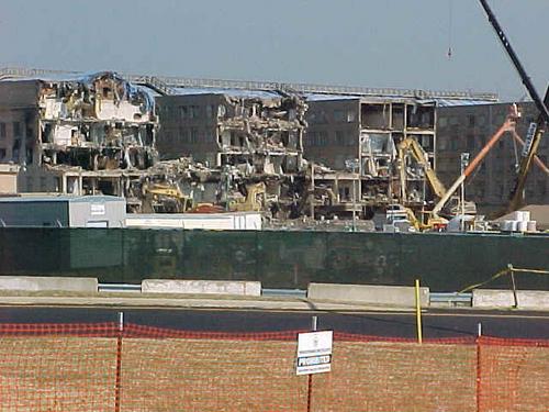
Yeah but the C ring is a hole, not a mangled disconjuction of damaged. it was a punch hole. It suggests that debris were intact to create it in the
shape of the aircraft.
Zaphod when that plane travelled through the Pentagon it was getting dismangled by the explosion of the fuel tanks being ruptured, the concrete walls
of the exterior ring, the masonic walls (which yeah probably didn't have that much strength), and ripped through the vertical structure steel support
columns but an intact piece of debris managed to puncture a pretty nice even hole through the last wall of the C ring?
I'm not trying to be unreasonably, show ignorance and have a subjectiveness based off of conspiracy but I'm trying to work through this reasonably.
As I said, I'm still on the fence.
I realize all that, but you have to realize that the wheel rims weigh somewhere around 3-400 pounds each. I helped change a wheel brake on a KC-135,
which is a 707-320, a generally smaller airplane, that weighed in at somewhere around 600 pounds. A 757 brake is going to be heavier. So you're
talking small parts, but very heavy small parts.
I may say this wrong, so bear with me. I know what I want to say but not quite how to say it.
The plane came apart into pieces, but many of those pieces didn't just go flying off to the sides. The fuselage parts (the heavier ones at least)
probably would have stayed together in a group. Not intact, but not flying apart either. That group of parts would have hit the wall in a relatively
small area and could have created that punch out hole.
Edit to add:
If you look at the colums in one of the diagrams on that page, there's a straight shot from entry to exit where debris could have gone through with
only two colums blocking part of the path it would have taken.
[edit on 8/24/2006 by Zaphod58]
I know Zaphod but look at the exit hole for the C ring, that seems very refined for something that would of been so amassed as chaotic debris
conjectured together in the direction of force.
Was there any damage to the B ring?
[edit on 8/24/2006 by Masisoar]
No. There were only three rings damaged. That hole also could have been expanded before that picture was taken. Rescue crews would have wanted to
get in there any way they could and that hole would have been the perfect way to get in there.
I just want to see the videos they confiscated, I wasn't there and there's not enough video evidence to help explain what happened.
But yes it does look like a 757 hit it, but I'm honestly still on the fence. The Pentagon's the only issue with the 9/11 Conspiracy I've been very
hesitant on tackling and unsure how to take an approach to attack the situation objectively. In my mind there's the huge idea that, as I've said, of
the inconvienence of having to deal with covering up the aircraft in the first place if something else hit the Pentagon.
Survellience videos = For the Win.
Edit: Deny my ignorance :-(
[edit on 8/25/2006 by Masisoar]
Zapho, Masisoar, the hole really was expanded in order to get into the building before these pics were taken, that's why it's so neat.
Wrong, Tuccy. You can see in this picture that smoke is still billowing out of the hole.
Originally posted by tuccy Zapho, Masisoar, the hole really was expanded in order to get into the building before these pics were taken, that's why it's so neat.

Originally posted by In nothing we trustCan you back that up?
Originally posted by Zaphod58 As has been stated several times, the exit hole was expanded by rescue crews to get access into the building. It was a small punchout by the landing gear, then it was made bigger by people trying to get into the building.
Originally posted by In nothing we trustChisel marks or blast fractures?
Originally posted by Zaphod58 The fact that there are chisel marks around the outer edge of the hole are a pretty good indication of it.
[edit on 25-8-2006 by In nothing we trust]
Originally posted by In nothing we trustThat's blast fracturing. Compare the punch out hole to a picture of a blasting explosive planted within rock. Notice how there is fracturing around the blast hole which has cause some of the surrounding rock (brick in the case of the penatgon) to flake off.
Originally posted by Zaphod58 On the outside edges going inward? And roughly the size of a chisel? I'd have to go with chisel marks.That's explosive force expeling alot of energy outwards. www.abovetopsecret.com...


Smoke billowing out is not a proof it wasn't expanded, as the firemen's job would be to go there even if the smoke is still there
As for the "blast" marks, where did the blast come from? Besides, behavior of the rock under explosive blast and masonry under mechanical impact
(esp. from the opposite side) would be different IMHO, so the "blast marks" are rather result of tools used in expanding the hole from the outside.
That was only the outermonst wall, not the interior partitions.
Originally posted by Masisoar What am I incorrect about HowardRoark? 911research.wtc7.net...
The renovation program included the following improvements to the building: * Exterior walls reinforced with steel * Exterior walls backed with Kevlar * Blast-resistant windows installed * Fire sprinklers installed * Automatic fire doors installed * Building operations and control center created
For admiting you made a mistake.
You have voted Masisoar for the Way Above Top Secret award. You have two more votes this month.
catherder,
according to the ntsb flight data recorder, the elevation of the aircraft ONE SECOND before impact was 480 ft above sea level. the light poles the aircraft allegedly hit would have had to be be over 400 ft tall to have been impacted by the aircraft, which is impossible. this analysis (summarized below) was conducted by Pilots for 911 Truth, which is working together with Scholars for Truth and Veterans For Truth and currently has at least 10 pilots as part of its organization. Together, they have a vast amount of flight experience with multiple, major airlines, and they totally concur with the 911 panels suspicion of widespread decpetion by the pentagon.. now, i dont have any idea what your experience is, so until i i know more about yours i will humbly defer to that of PFTs. let me just state for the record: the idea that a bunch of ragheads who could barely fly a cessna pulled off the type of aeronautical maneurvers that flight 77 managed before impact - which is nothing short of spectacular - is simply beyond belief. the same goes for the alleged 'pilots' of the other aircraft, none of whom were "instrument rated" (as far as i know) and yet managed to fly hundreds of miles, back and forth, around and around .. and still managed to ALL locate their respective targets. i'm not instrument rated and i can personally vouch for the difficulty of going *anywhere* - regardless of weather. nevertheless, kudos to an excellent presentation on your part. unfortunately, there are far too many questions remaining open to accept the official gov statement. Flight Data Recorder Analysis Last Second of Data 09:37:44 08/20/06 We have determined based on the Flight Data Recorder information that has been analyzed thus far provided by the NTSB, that it is impossible for this aircraft to have struck down the light poles. We have an animation of the entire flight provided by the NTSB. I have sat through the whole flight from taxi out at Dulles... to the impact at the Pentagon in real time. The screenshot below shows the very last frame of the recorded data. Its stops at 9:37:44 AM EDT (Official Impact Time is 09:37:45). You will notice in the right margin the altitude of the aircraft on the middle instrument. It shows 180 feet. This altitude has been determined to reflect Pressure altitude as set by 29.92 inHg on the Altimeter. The actual local pressure for DCA at impact time was 30.22 inHg. The error for this discrepancy is 300 feet. Meaning, the actual aircraft altitude was 300 feet higher than indicated at that moment in time. Which means aircraft altitude was 480 feet above sea level (MSL, 75 foot margin for error according to Federal Aviation Regulations). You can clearly see the highway in the below screenshot directly under the aircraft. The elevation for that highway is ~40 feet according to Google Earth. The light poles would have had to been 440 feet tall (+/- 75 feet) for this aircraft to bring them down. Which you can clearly see in the below picture, the aircraft is too high, even for the official released video of the 5 frames where you see something cross the Pentagon Lawn at level attitude. The 5 frames of video captured by the parking gate cam is in direct conflict with the Aircraft Flight Data Recorder information released by the NTSB. More information will be forthcoming as we come to our conclusions on each issue. We have contacted the NTSB regarding the conflict between the official story and the FDR. They refuse to comment. www.pilotsfor911truth.bravehost.com... [edit on 2-9-2006 by stillprepping]
catherder: According to the NTSB: Data from the flight recorder showed that; the plane was travelling at 400 knots (780 ft/s) (512.9 mph) at a magnetic bearing of 70 degrees when it struck the Pentagon. It had approximately 36,200lb of fuel (5,300 gal) and weighed approximately 181,520lb
Couple of issues. The altitude would be based on the barometric pressure at that area at that time. So how do they get the 480ft? What did they base
that on? Also, we're talking about above sea level. How high above sea level were the light poles? Obviously not at exactly sea level. So there is
some fishy sutff going on by these web sites. We realy need some experts to get involved with this and not just those who are set on proving a
conspiracy. Not to rule one out of course, but to be objective.
Wasn't hard to find...
www.idcide.com...
Elevation: 18 feet above sea level. Land Area: 61.4 Square Miles. Water Area: 6.9 Square Miles...
but thats just for the general area of Washington. I doubt it is perfectly flat for every square inch. And again, without the proper barometer readings for that area at the time and day, where would they get the figures from to make their claims?
Originally posted by ANOK Wasn't hard to find...www.idcide.com...
Elevation: 18 feet above sea level. Land Area: 61.4 Square Miles. Water Area: 6.9 Square Miles...
The highest point of Arlington County, Virginia (where the pentagon is located) is 461 feet above sea level.
So Snoopy why don't you do some resrearch then?
You come here saying we need to know this and that, and trying to de-bunk everything.
Yet you expect everyone else to provide the info you need to do your de-bunking?
I was just trying to point out that info is out there, go look.
Then you do the math.
I look fwd to your results.
So, the hijackers weren't all that great in flying. Do you think perhaps that they had persuaded the pilot, who I understand had a real great resume
on piloting I think I read somewhere on these forums, persuaded the pilot to do the work for them? Maybe he got caught in a bind, "I'm gonna die
anyways, let's hope that they shoot us down and kill these bastards before I hit!"....
I don't know, just a thought.
So you want me to reseach someone elses claims? It doesn't work that way my friend. If they are going to claim the plane was at 480ft, then they need to disclose how they came to that figure. Not me. Don't give me that bullshit justbecause someone DARE question the issue. If you want to accept only what you want to hear then fine, but don't give someone else shit because they want actual evidence of such claims. If I just wanted to hear nothing but empty conspiracies, I would jsut go to Prisonplanet where facts needent be checked.
Originally posted by ANOK So Snoopy why don't you do some resrearch then? You come here saying we need to know this and that, and trying to de-bunk everything. Yet you expect everyone else to provide the info you need to do your de-bunking? I was just trying to point out that info is out there, go look. Then you do the math. I look fwd to your results.
Unfortuneatly you missed my point and you are twisting what I said. I'm not supporting anybodies theory, just want to hear more than opinions on whether it's right or wrong. If you claim he's wrong, I have no idea myself, then let's see your research to dispute it. So no, you would not be researching someones elses claim, you would be researching your own.
Originally posted by snoopy So you want me to reseach someone elses claims?
new topics
-
Arizona Supreme Court says 98,000 People with Unconfirmed Citizenship Can Vote
2024 Elections: 2 hours ago -
No more Kids .......
Social Issues and Civil Unrest: 3 hours ago -
“Am I Racist?” - Matt Walsh Explodes DEI Grifters Minds
Movies: 9 hours ago -
Russia labels Saami organizations as terrorists.
Other Current Events: 11 hours ago
top topics
-
“Am I Racist?” - Matt Walsh Explodes DEI Grifters Minds
Movies: 9 hours ago, 11 flags -
The iceberg that brought down the Titanic was a Russian spy
ATS Skunk Works: 13 hours ago, 9 flags -
Russia labels Saami organizations as terrorists.
Other Current Events: 11 hours ago, 6 flags -
No more Kids .......
Social Issues and Civil Unrest: 3 hours ago, 6 flags -
Arizona Supreme Court says 98,000 People with Unconfirmed Citizenship Can Vote
2024 Elections: 2 hours ago, 5 flags
active topics
-
The Security Failures Had to Be Intentional - Making it Easier for TRUMP to be SHOT on 7-13-2024.
General Conspiracies • 85 • : WeMustCare -
The iceberg that brought down the Titanic was a Russian spy
ATS Skunk Works • 33 • : Imhere -
Cell phones exploding in Lebanon mass casualties
Middle East Issues • 93 • : jofafot -
“Am I Racist?” - Matt Walsh Explodes DEI Grifters Minds
Movies • 11 • : JadedGhost -
No more Kids .......
Social Issues and Civil Unrest • 23 • : BernnieJGato -
Diddy Arrested in NYC After Grand Jury Indictment
Other Current Events • 11 • : Coelacanth55 -
Arizona Supreme Court says 98,000 People with Unconfirmed Citizenship Can Vote
2024 Elections • 7 • : WeMustCare -
So this is what Hamas considers 'freedom fighting' ...
War On Terrorism • 291 • : ToneD -
KAMALA HARRIS Told Reporters Homes of Gun Owners Will Be Searched to Ensure Compliance.
2024 Elections • 30 • : WeMustCare -
Kamala Harris tells Oprah she will kill an intruder
US Political Madness • 42 • : WeMustCare