It looks like you're using an Ad Blocker.
Please white-list or disable AboveTopSecret.com in your ad-blocking tool.
Thank you.
Some features of ATS will be disabled while you continue to use an ad-blocker.
share:
Magnitude 6.0 - Hindu Kush Region Afghanistan
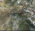
Location map by EMSC (Google Map)
- Date-Time: Thursday, July 12, 2012 @ 14:00:35 UTC
- Earthquake location: 36.657°N, 71.059°E,
- Earthquake depth: 200.0 km
- Distances:
276 km NE Kabul (pop 3,043,532 ; local time 18:30:32.9 2012-07-12)
185 km E Qunduz (pop 161,902 ; local time 18:30:32.9 2012-07-12)
33 km S Jurm (pop 12,106 ; local time 18:30:32.9 2012-07-12)
- Event ID: 277808
Derived from Event Data Source: EMSC
Powered by QVSData
USGS just came in at 5.8 and EMSC dropped it to 5.8 mb which seems a bit pointless as that is the equivalent of 6.0 Mw
Magnitude 5.8 - Hindu Kush Region. Afghanistan
Location in Google Maps
- Date-Time: Thursday, July 12, 2012 @ 14:00:33 UTC
- Earthquake location: 36.502°N, 70.875°E,
- Earthquake depth: 190.2 km
- Distances:
40km (24mi) S of Jarm, Afghanistan
62km (38mi) WSW of Ashkasham, Afghanistan
70km (43mi) WSW of Ishkashim, Tajikistan
73km (45mi) SSE of Fayzabad, Afghanistan
267km (165mi) NE of Kabul, Afghanistan
- Event ID: usb000b40i
Derived from Event Data Source: USGS
Powered by QVSData
Geofon have 5.7 Mw (automatic) for this one.
Unlikely to have caused damage of any great nature - too deep.
What a little beauty!!! That is no 5.8 showing that strong at that depth. (Seismo is 270 km from the epicentre)
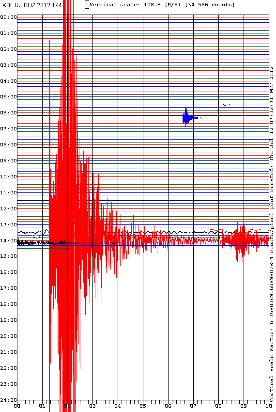
and also DRK.KR..BHZ.2012.194 (340 km away)
USGS phase data is now available. 5.7 mb = 5.87 Mw approx. This could make the Mag 6 yet (In about 10 days time )
edit on 12/7/2012 by PuterMan because: (no reason given)
I am always fascinated by these seismos and the odd things you can see on them. This really should be a Quake Nerds Corner item but I will put it here
first anyway.
Take a look at this supersized me version of the seismo above.
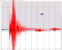
On the 13:20 red line at ~13:27:40 you can see an event starting that continues for around 30 minutes that looks like it could be a very long drawn out telesiesm as we do often see. Either that or it was the HAARP signal setting off the earthquake NOT NOT NOT
You can see where this signal starts
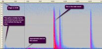
Is it a distant earthquake? Well yes it most certainly is even though the trace is not what you might recognise as one.
If I 'squash' that signal so it is all bunched up it looks like this:
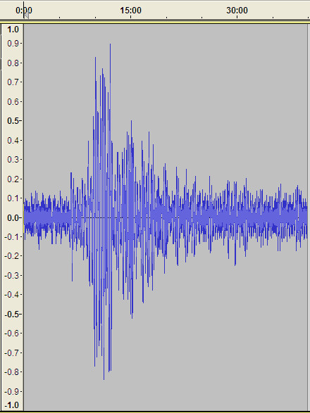
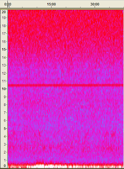
Now it is beginning to look like an earthquake. Flicking over to the spectro view it looks nothing
There appears to be about 3 minutes and 24 seconds or so between what might be the P and S wave signals so that is 204 seconds which as a 'guess' using 5km / second gives us 1020 km away.
1020 km / 8 is 128 seconds so around 2 minutes. We are looking for an event that was about 13:25. Nothing fits. There is certainly nothing capable of doing that a few minutes earlier. This seems ridiculously short and the signal is wrong for something so close.
But what if the first 'blip' at 13:02 or so is actually the P wave?
That would give 25 or even 30 minutes between P and S or maybe surface. If that was the case we would be looking at 25 * 60 * 5 = 7500 km distance. The trace definitely has more of a feel of that sort of distance.
Based on 8km for the P and 3 km for the S that places the time as 7500/8 = 938 seconds = 15.6 minutes or about 12:45 ish.
Kuril looks like a good candidate This is 6,800 km away from the other epicentre, and the quake was at 12:52
Date/Time UTC,Latitude,Longitude,Magnitude,Depth(Km),Location
2012-07-12T15:40:12.000Z,-2.81100,129.34500,5.5000,9.9000,Seram. Indonesia
2012-07-12T14:00:33.000Z,36.50150,70.87540,5.8000,190.2000,Hindu Kush region. Afghanistan
2012-07-12T12:52:02.000Z,45.45570,151.69090,5.7000,34.9000,Kuril Islands
This timing and distance would give us 11.33 km per second for the P wave and 3.24 km per second for the S wave - approximately because the 13:27 data could be the surface wave but that is unlikely as the distance/time rough calc would not work then.
So does the Kuril quake register on the KBL station in the phase data. Yup!
Look down the list above and you will find KBL registering the quake at 13:02
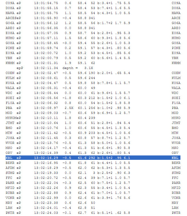
QED
Thus a rat is demonstrated!
Take a look at this supersized me version of the seismo above.

On the 13:20 red line at ~13:27:40 you can see an event starting that continues for around 30 minutes that looks like it could be a very long drawn out telesiesm as we do often see. Either that or it was the HAARP signal setting off the earthquake NOT NOT NOT
You can see where this signal starts

Is it a distant earthquake? Well yes it most certainly is even though the trace is not what you might recognise as one.
If I 'squash' that signal so it is all bunched up it looks like this:

Now it is beginning to look like an earthquake. Flicking over to the spectro view it looks nothing

There appears to be about 3 minutes and 24 seconds or so between what might be the P and S wave signals so that is 204 seconds which as a 'guess' using 5km / second gives us 1020 km away.
1020 km / 8 is 128 seconds so around 2 minutes. We are looking for an event that was about 13:25. Nothing fits. There is certainly nothing capable of doing that a few minutes earlier. This seems ridiculously short and the signal is wrong for something so close.
But what if the first 'blip' at 13:02 or so is actually the P wave?

That would give 25 or even 30 minutes between P and S or maybe surface. If that was the case we would be looking at 25 * 60 * 5 = 7500 km distance. The trace definitely has more of a feel of that sort of distance.
Based on 8km for the P and 3 km for the S that places the time as 7500/8 = 938 seconds = 15.6 minutes or about 12:45 ish.
Kuril looks like a good candidate This is 6,800 km away from the other epicentre, and the quake was at 12:52

Date/Time UTC,Latitude,Longitude,Magnitude,Depth(Km),Location
2012-07-12T15:40:12.000Z,-2.81100,129.34500,5.5000,9.9000,Seram. Indonesia
2012-07-12T14:00:33.000Z,36.50150,70.87540,5.8000,190.2000,Hindu Kush region. Afghanistan
2012-07-12T12:52:02.000Z,45.45570,151.69090,5.7000,34.9000,Kuril Islands
This timing and distance would give us 11.33 km per second for the P wave and 3.24 km per second for the S wave - approximately because the 13:27 data could be the surface wave but that is unlikely as the distance/time rough calc would not work then.
So does the Kuril quake register on the KBL station in the phase data. Yup!
Look down the list above and you will find KBL registering the quake at 13:02

QED
Thus a rat is demonstrated!
edit on 12/7/2012 by PuterMan because: (no reason given)
Originally posted by PuterMan
But what if the first 'blip' at 13:02 or so is actually the P wave?
Great work Sherlock, the Kuril quake fits perfectly;
as can be seen from the TravelTimesComputer results
Station Coordinates : 34.5400009 69.0400009 (Kabul)
Earthquake Latitude and Longitude: 45.4560013 151.690994 (Kuril islands)
Earthquake Depth (km): 35.
Earthquake Time: 12:52:02
Earthquake Magnitude: 5.69999981
Arrival Times
P = 13:02:16
S = 13:10:36
LR = 13:20:57
I know you guys deal with earthquakes, but I'm wondering if you can tell me where to look for information concering the solar flare headed our way?
Supposed to be large enough to knock out communication grids. They just told something about it on the news my sister was watching, but she didn't
know what network told it, and I can't find anything about it online.
Thanks for any info, and sorry for derailing your thread.
Never mind. I started a thread, and already have lots of info about it. Thanks anyway.
Thanks for any info, and sorry for derailing your thread.
Never mind. I started a thread, and already have lots of info about it. Thanks anyway.
edit on 7/12/2012 by sled735 because: (no reason
given)
reply to post by sled735
Hiya Sled, please next time if you ask a question and find an answer yourself - please give us a linky poo - to help the others who are still unaware.. :-)
Solar Info.
We shall see what happens in the quake world in the next few days.
Wondering what's up here?
Also got my little peepers tuned into the Yucca Valley.....
Oh and btw - in case you haven't seen it yet, Slayer 69 put together an Awesome Video for us members - a Must See :-)
Hiya Sled, please next time if you ask a question and find an answer yourself - please give us a linky poo - to help the others who are still unaware.. :-)
Solar Info.
We shall see what happens in the quake world in the next few days.
Wondering what's up here?
4.8 48km NNW of Visokoi Island, 2012-07-13 00:38:23 56.298°S 27.502°W 93.3
4.7 61km SSE of Bristol Island, Antarctica 2012-07-10 10:43:51 59.568°S 26.241°W 15.6
5.2 196km E of Visokoi Island, 2012-07-08 14:41:23 56.387°S 24.058°W 14.8
4.7 110km N of Visokoi Island, 2012-07-07 23:31:45 55.715°S 27.421°W 35.1
5.4 53km NNW of Visokoi Island, 2012-07-07 08:11:36 56.240°S 27.443°W 97.0
Also got my little peepers tuned into the Yucca Valley.....
Oh and btw - in case you haven't seen it yet, Slayer 69 put together an Awesome Video for us members - a Must See :-)
Originally posted by Anmarie96
reply to post by sled735
Hiya Sled, please next time if you ask a question and find an answer yourself - please give us a linky poo - to help the others who are still unaware.. :-)
Solar Info.
We shall see what happens in the quake world in the next few days.
Okay, sorry 'bout that! Had to leave for work last night. Here is a link to the thread I started about the solar flares coming. Lots of good linky poos being given in the thread.
www.abovetopsecret.com...
edit on 7/13/2012 by sled735 because: (no reason given)
edit on 7/13/2012 by sled735 because: (no reason given)
Reference Number 3738043
Universal Time July 13 2012 at 14:01
NZ Standard Time Saturday, July 14 2012 at 2:01 am
Latitude, Longitude 38.52°S, 176.97°E
Focal Depth 60 km
Richter magnitude 5.3ML
Region Bay of Plenty
Location
30 km east of Murupara
40 km south of Waimana
60 km south of Whakatane
270 km south-east of Auckland
www.geonet.org.nz...
GFZ=4.9mb
GeonetRapid picked it at 5.0 then down to 4.8 @11 minutes after.
URZ graph
usgs asleep at the tiller again? no mention of it
edit on 13-7-2012 by muzzy because: (no reason given)
Noticed one or four of these the other day, then again just before the 5.268ML this morning pip, pip, pip, pip, pip, pip, pip, pip, pip
......................... kaboom! 1200 tons of TNT went off
Mt. Tongariro volcano is about 135km to the SW of the 5.3 epi-center.
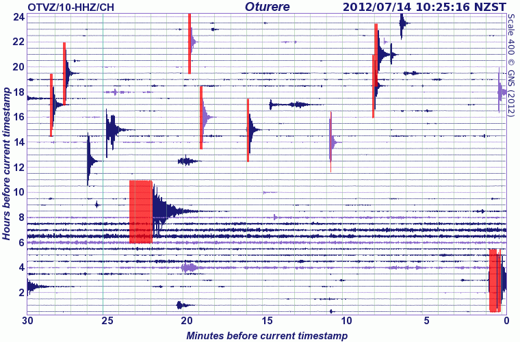
I'd love to know whats going on under our North Island, for about a week there was nothing going on the east coast at all. Now another one 4.2 Ormond, near Gisborne, again NE of the 5.3
Just doing the maps now, you will be able to see it on the 7 Days map (link in my signature) in about an hour.
for those who don't want to go blogging, heres the interactive map on GMaps. goo.gl...
Not sure what that swarm offshore Port Taranaki is about either. The one further south near Okato is petty normal, been doing that for years, has something to do with Taranaki volcano, which never seems to have any quakes under the cone itself.
I wonder if the 5.7 on the 7th July set off this Tongariro activity, it wasn't far away.
Mt. Tongariro volcano is about 135km to the SW of the 5.3 epi-center.

1.565, -39.10331, 175.64943, 2012/7/11 6:56:13.8, 4, Tongariro Alpine Crossing
2.2, -39.32959, 175.89491, 2012/7/11 7:56:39.7, 64, Waipakihi Rd, Tongariro National Park
1.627, -39.0242, 175.73146, 2012/7/11 13:36:31.8, 7, Te Ponanga Saddle Rd, Tongariro National Park
1.706, -39.1305, 175.64999, 2012/7/11 17:5:9.8, 5, Tongariro Alpine Crossing
1.693, -39.09222, 175.67754, 2012/7/12 23:18:34.9, 0, Tongariro Alpine Crossing
1.808, -39.11419, 175.66118, 2012/7/13 0:35:21.5, 0, Tongariro Alpine Crossing
2.39, -39.11688, 175.66876, 2012/7/13 1:47:2.9, 7, Tongariro Alpine Crossing
2.076, -39.11435, 175.66359, 2012/7/13 2:57:32.2, 3, Tongariro Alpine Crossing
2.014, -39.11458, 175.66205, 2012/7/13 4:16:51.5, 3, Tongariro Alpine Crossing
2.161, -39.11603, 175.66104, 2012/7/13 5:26:42.6, 3, Tongariro Alpine Crossing
2.095, -39.1125, 175.65572, 2012/7/13 6:36:7.2, 7, Tongariro Alpine Crossing
2, -39.11562, 175.66591, 2012/7/13 7:39:1.4, 4, Tongariro Alpine Crossing
1.68, -39.11626, 175.66306, 2012/7/13 8:44:12.2, 6, Tongariro Alpine Crossing
1.777, -39.08986, 175.64685, 2012/7/13 9:59:3.0, 5, Tongariro Alpine Crossing
I'd love to know whats going on under our North Island, for about a week there was nothing going on the east coast at all. Now another one 4.2 Ormond, near Gisborne, again NE of the 5.3
Just doing the maps now, you will be able to see it on the 7 Days map (link in my signature) in about an hour.
edit on 13-7-2012 by muzzy
because: (no reason given)
for those who don't want to go blogging, heres the interactive map on GMaps. goo.gl...
Not sure what that swarm offshore Port Taranaki is about either. The one further south near Okato is petty normal, been doing that for years, has something to do with Taranaki volcano, which never seems to have any quakes under the cone itself.
I wonder if the 5.7 on the 7th July set off this Tongariro activity, it wasn't far away.
edit on 13-7-2012 by muzzy because: (no reason
given)
Originally posted by PuterMan
Fascinating line up in the Kuril Islands if you are into that sort of thing. All the depth bands represented and almost a straight line.
Wait for the big one any day now!
Ya think?
Being into that sort of thing myself , I had a closer look at the area.
As you no doubt have seen on the data coming in since your map image there have been some more quakes, I had 27 when I last looked, when I did the maps.
Based on the historical data which Utsu has for the Kuriles, back to 1742, and additional NOAA since 1993 there have been 2 very-strong and one major quakes in the area 1918 and 1967, which indicates a recurrance period of 46 years, so next one not due till 2016.
All speculation of course, as we only have 270 years data to work with.
I didn't bother with ANSS in this case, I'll have a look after breakfast, there are probably some more historical 6's in there too, maybe, but it doesn't really affect the recurrance concept as there is a 6.1 in this swarm anyway.
This is probably the best map, has the numbers of the quakes in the swarm in sequence and also the historical data.
interactive version - goo.gl...
screenshot -
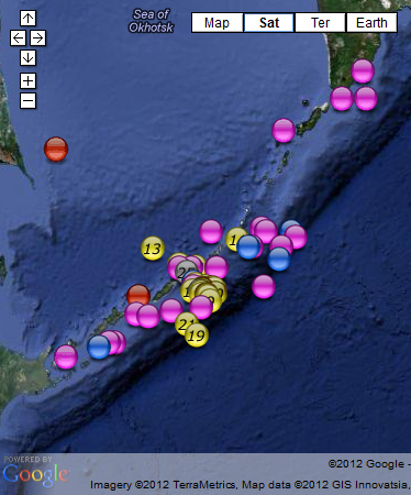
I'm calling it a "Swarm" as there were some decent sized 5's before the largest 5.9 (6.1Ms) , and there are two others 5.8 and 5.8 (5.9Ms) in the time period.
edit on 14-7-2012 by muzzy because: to add the following
Total energy released based on mb readings = 37,980.33 tons of TNT equivalent to a single 6.267mb quake, or using the Geofon/EMSC mb-Mw conversion formula (Mw = 0.7813mb + 1.5175), 6.414Mw
link to page I wrote up, with some more maps Kuril Islands Swarm 2012 July 7th to 14th
edit on 14-7-2012 by muzzy because: to add what I just wrote, and fix a couple of spelling mistakes
reply to post by muzzy
I saved and added some IRIS BHZ graphs from ERM :: Erimo, Hokkaido Island, Japan to the page
that one on Sakhalin was a bit of a mess.
I saved and added some IRIS BHZ graphs from ERM :: Erimo, Hokkaido Island, Japan to the page
that one on Sakhalin was a bit of a mess.
reply to post by muzzy
Wow, I'm impressed. You created zillions of markers with numbers! Care to try the bif swarm at Yellowstone a couple of years ago with several thousand quakes!!!
Very good. I still see the straight lines there. I feel a sawtooth coming on.
Wow, I'm impressed. You created zillions of markers with numbers! Care to try the bif swarm at Yellowstone a couple of years ago with several thousand quakes!!!
Very good. I still see the straight lines there. I feel a sawtooth coming on.
This is going to be a typo free post! bif??? wth is bif, oh yes big 'cos the 'fuh' and the 'guh' are right next to each other.
Now, anyway, does this look odd to anyone or is it just me?
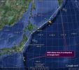
The line of quakes are all in a three day space and almost run south to north in sequence - almost but not quite.
Now, anyway, does this look odd to anyone or is it just me?

The line of quakes are all in a three day space and almost run south to north in sequence - almost but not quite.
4 more quakes at the Kurils Swarm
data by RAS
I hope there are no more, I've only got numbered icons up to 31, where we are at right now.
text added and maps updated, ERM 14.07.2012 graph updated and 15.07.2012 graph added page still has the same link name, but title renamed to Kuril Islands Swarm 2012 July 7th to 15th
15/07/2012 15:52:48, 45.09, 151.41, 33, 4.7, Kuril Islands, 169.20
15/07/2012 14:34:45, 43.28, 146.47, 60, 5.3, Kuril Islands, 1344.03
15/07/2012 9:50:31, 46.27, 151.4, 33, 4.6, Kuril Islands, 119.79
14/07/2012 18:48:33, 45.48, 151.77, 33, 5, Kuril Islands, 476.88
and one further SW towards Hokkaido
14/07/2012 17:36:24, 45.39, 151.94, 33, 5.4, Kuril Islands, 1898.49
data by RAS
I hope there are no more, I've only got numbered icons up to 31, where we are at right now.
text added and maps updated, ERM 14.07.2012 graph updated and 15.07.2012 graph added page still has the same link name, but title renamed to Kuril Islands Swarm 2012 July 7th to 15th
edit on 15-7-2012 by muzzy because: don't know what happened there, double text
reply to post by PuterMan
not zillions but I have made 32 numbers (incl. 0 ) x 8 colours (representing the magnitudes), so thats 256 icons minus the pink 0 and blue 0 that I didn't make at the time, so 254 of them.
I originally started making them for the Vanuatu study I was doing then expanded it to have enough numbers to do a month of days.
If this swarm goes on some more I'll have to make some new icons
What made is easier is I installed Dropbox on my computer, so can save files directly there without having to use their web site page, KMZ files will save directly off Google Earth, other files just drag and drop into the folders, they automatically become available for viewing on the web.
Re the line of epi-centres, yes I seen that originally, but as time has moved on the events have spread out a bit.
Looks like a NW/SE fault in the Kuril Ridge.
edit on 15-7-2012 by muzzy because: (no reason given)
SDF to start quake drills with US military
www3.nhk.or.jp/daily/english/20120716_04.html
www3.nhk.or.jp/daily/english/20120716_04.html
Japan's Self-Defense Forces will conduct simulation drills on Monday to prepare for a major earthquake whose focus is expected to be directly underneath Tokyo.
This year's 5-day exercise will be the first since the earthquake and tsunami struck northeastern Japan last year.
Around 5,000 mostly SDF personnel will take part in the drills. The US military will also participate in the exercises for the first time.
Police officers, firefighters and government officials will be on hand to examine the movement of SDF units and transport routes for relief goods mainly using a map.
The SDF will deploy its members to Tokyo's ward offices for the first time. They will check routes to the offices by walking there themselves.
The SDF will also set up coordination posts with US troops to study how best to divide their roles.
Immediately after last year's disaster, coordination stations were understaffed, and as a result the SDF and the US military failed to swiftly carry out relief operations.
The SDF will use lessons from the drills to review by December how well their disaster preparedness plans for the possible huge quake measure up.
In 2006, the SDF began conducting map drills under the assumption that a massive disaster had struck somewhere in Japan.
Jul. 15, 2012 - Updated 20:29 UTC (05:29 JST)
Copyright NHK (Japan Broadcasting Corporation) All rights reserved.
21:02 16 July
Niigata marks 5th anniversary of fatal Chuetsu quake
NIIGATA, Japan, July 16, Kyodo
english.kyodonews.jp/news/2012/07/169844.html
Niigata marks 5th anniversary of fatal Chuetsu quake
NIIGATA, Japan, July 16, Kyodo
english.kyodonews.jp/news/2012/07/169844.html
A memorial ceremony was held Monday in Kashiwazaki, Niigata Prefecture, to mark the fifth anniversary of a magnitude 6.8 earthquake that claimed 15 lives.
About 500 attendants took a moment of silence at 10:13 a.m., the time the quake hit the coast of the Chuetsu region in the prefecture and Tokyo Electric Power Co.'s Kashiwazaki-Kariwa nuclear plant, located 16 kilometers away from the epicenter, where four running reactors automatically shut down.
Since the plant's No. 6 reactor was suspended March 26, all seven reactors are offline at the plant for regular checkups with no prospects for resumption in the aftermath of the nuclear accident at the utility's Fukushima Daiichi power plant in Fukushima Prefecture, triggered by the March 2011 earthquake and tsunami in northeastern Japan.
"I hope to help other prefectures recover from the disasters," 57-year-old Haruo Motoi, who lost his mother in the 2007 quake, said, referring to the natural and nuclear disasters last year. "I hope to make July 16 the day we learn from the tragedy."
A total of 15 people were killed in the city of Kashiwazaki and the village of Kariwa in the quake, while 2,346 others were injured in Niigata, Nagano and Toyama prefectures. Most died after being buried under flattened homes.
"Recovery work has gone well, and it's very encouraging," disaster management minister Masaharu Nakagawa said. "We'll continue to make efforts to become a disaster-resilient country."
Nakagawa, along with Niigata Gov. Hirohiko Izumida and others, visited the Kitajo district of Kashiwazaki city, which was also hit by a major quake in October 2004. They were briefed on measures taken for evacuating elderly and physically disabled people.
Copyright 2012 Kyodo News
edit on 16-7-2012 by amcpwoy because: (no reason given)
Originally posted by amcpwoy
21:02 16 July
Niigata marks 5th anniversary of fatal Chuetsu quake
A total of 15 people were killed in the city of Kashiwazaki and the village of Kariwa in the quake, while 2,346 others were injured in Niigata, Nagano and Toyama prefectures. Most died after being buried under flattened homes.
I don't remember that one but as usual its not the earthquake that kills people its the collapsing buildings, and I guess many of the others who have died over the years it was landslides, tsunamis and heart attacks.
maybe the Italians and Greeks have the right idea, instead of crouch, cover and hold
- RUN OUTSIDE
after all they been practicing for centuries
edit on 16-7-2012 by muzzy because: (no reason given)
02:04 17 July
Research shows Shika atomic plant may sit on active quake fault
TOKYO, July 17, Kyodo
english.kyodonews.jp/news/2012/07/169874.html
Research shows Shika atomic plant may sit on active quake fault
TOKYO, July 17, Kyodo
english.kyodonews.jp/news/2012/07/169874.html
Governmental research has suggested a strong possibility that a fault beneath Hokuriku Electric Power Co.'s Shika Nuclear Power Station may be active, raising questions about the utility's claim in the late 1990s that it is inactive, sources familiar with the research said Monday.
Government regulations do not allow construction of a nuclear reactor above an active quake fault. If it is confirmed active, the Shika power station may be labeled as sitting on premises ineligible for a nuclear power plant.
The research by the Economy, Trade and Industry Ministry's Nuclear and Industrial Safety Agency shows the fault -- technically named S-1, which runs southeast to northwest within the premises -- moved sometime after 130,000 to 120,000 years ago, the sources said.
Hokuriku Electric Power conducted excavation surveys when it applied for building a second reactor for the plant in 1997 and, based on it, said the fault "does not indicate activity."
In a review of fault lines after the Great East Japan Earthquake of March 11, 2011, NISA went through excavation data presented by Hokuriku Electric and came to a conclusion that the research suggests a strong possibility that S-1 may have been active in a relatively recent period.
Geological layers comprised not just bedrock from ancient periods but sand and pebbles from a period dating back to 130,000 to 120,000 years and they were deformed, according to the sources.
It remains unknown at this point if S-1 generates a quake on its own or shakes ground in association with nearby active faults. Given that another fault lies beneath the No. 2 reactor, if the two faults jolt at the same time, it could throw the plant into danger.
Mitsuhisa Watanabe, a geomorphology professor at Toyo University, said, "I must say Hokuriku Electric is making a far-fetched assessment in saying that geological layers of 130,000 to 120,000 years have not been morphed."
Watanabe said the fault is suspected of having been active in a later period.
Research and surveys by NISA have suggested that a soft fault layer, called a crushed zone, could move at Japan Atomic Power Co.'s Tsuruga Nuclear Power Station in Fukui Prefecture, raising the possibility that the plant may have to be shut down.
Citizens are also calling for research into Kansai Electric Power Co.'s Oi nuclear power plant relating to a similar soft fault layer.
Copyright 2012 Kyodo News
new topics
-
Potter to WHU
World Sports: 4 hours ago -
Dr. Demento
Music: 6 hours ago -
The elephant in the room (wearing a hoodie)
US Political Madness: 6 hours ago
top topics
-
The elephant in the room (wearing a hoodie)
US Political Madness: 6 hours ago, 12 flags -
Green Grapes
General Chit Chat: 17 hours ago, 7 flags -
To become president, Zelensky had to learn Ukrainian
Political Conspiracies: 13 hours ago, 6 flags -
Dr. Demento
Music: 6 hours ago, 5 flags -
Potter to WHU
World Sports: 4 hours ago, 1 flags
active topics
-
The Fight for Election Integrity Continues -- Audits, Criminal Investigations, Legislative Reform
2024 Elections • 4371 • : WeMustCare -
The Truth about Migrant Crime in Britain.
Social Issues and Civil Unrest • 40 • : gortex -
Los Angeles brush fires latest: 2 blazes threaten structures, prompt evacuations
Mainstream News • 161 • : Vermilion -
The elephant in the room (wearing a hoodie)
US Political Madness • 18 • : Irishhaf -
Trump says ownership of Greenland 'is an absolute necessity'
Other Current Events • 76 • : LSU2018 -
Potter to WHU
World Sports • 2 • : Bilbous72 -
Dr. Demento
Music • 12 • : GENERAL EYES -
President Carter has passed
Mainstream News • 45 • : WeMustCare -
To become president, Zelensky had to learn Ukrainian
Political Conspiracies • 30 • : Oldcarpy2 -
The Acronym Game .. Pt.4
General Chit Chat • 1037 • : tinkerbell99
