It looks like you're using an Ad Blocker.
Please white-list or disable AboveTopSecret.com in your ad-blocking tool.
Thank you.
Some features of ATS will be disabled while you continue to use an ad-blocker.
share:
Originally posted by PuterMan
reply to post by angelchemuel
www.jonfr.com...
Pour vous Madame. Enjoy!
Diolch yn fawr!
Rainbows
Jane
reply to post by muzzy
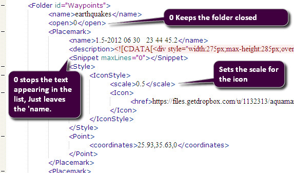
Google Maps does recognise the scale attribute. I tried altering a few of yours on the Greek one and it works fine.

I know it is a long time appearing but all this can be set automatically in the Pro version of QVSData. I am working on it but as you will imagine it is very complex to get all these settings right.
BTW if you have not read your email you have a problem with an h2 tag on you LDEO tab in Earthquake Archives.
reply to post by angelchemuel
You know I have known how to pronounce that for over 40 years but have never seen it written that I recall.
Diolch
Google Maps does recognise the scale attribute. I tried altering a few of yours on the Greek one and it works fine.

I know it is a long time appearing but all this can be set automatically in the Pro version of QVSData. I am working on it but as you will imagine it is very complex to get all these settings right.
BTW if you have not read your email you have a problem with an h2 tag on you LDEO tab in Earthquake Archives.
reply to post by angelchemuel
You know I have known how to pronounce that for over 40 years but have never seen it written that I recall.
Diolch
edit on 5/7/2012 by PuterMan because: I can't write English let alone the native tongue of my ancestors.
Looks as if something may have changed at EMSC. South America is now part of Europe. In this listing for today there are two Chilean quakes below 4.0
which is the normal cut off as I understanding it for non European events. (This is
their coverage area)
Looks as if we now should get Chilean quakes down to Mag 2.5
(Not that we did not have them, just in one place now!)
Prov,Date/Time UTC,Latitude,Longitude,Magnitude,Depth(Km),Location
emsc,2012-07-05 00:17:38, 37.025, 28.484, 2.2, 9.0, Western Turkey
emsc,2012-07-05 00:40:55, -28.085, -69.814, 3.0, 4.0, Atacama Chile
emsc,2012-07-05 00:58:39, 37.328, 28.765, 2.3, 6.0, Western Turkey
emsc,2012-07-05 01:15:06, 44.850, 11.264, 2.1, 12.0, Northern Italy
emsc,2012-07-05 01:35:29, 39.077, 29.155, 2.4, 5.0, Western Turkey
emsc,2012-07-05 02:11:38, 34.849, 33.306, 2.8, 45.0, Cyprus Region
emsc,2012-07-05 02:13:01, 40.401, 21.415, 3.4, 18.0, Greece
emsc,2012-07-05 02:20:11, 38.098, 25.604, 2.3, 28.0, Aegean Sea
emsc,2012-07-05 02:48:19, 37.880, 27.084, 2.7, 5.0, Western Turkey
emsc,2012-07-05 02:53:09, 38.461, 15.475, 2.1, 133.0, Sicily Italy
emsc,2012-07-05 02:59:34, 38.737, 16.065, 2.7, 49.0, Southern Italy
emsc,2012-07-05 03:09:17, 49.434, 155.264, 4.5, 71.0, Kuril Isls.
emsc,2012-07-05 03:14:16, 40.835, 43.565, 2.4, 15.0, Eastern Turkey
emsc,2012-07-05 03:47:42, 34.866, 23.145, 3.0, 16.0, Crete Greece
emsc,2012-07-05 04:02:38, -28.644, -69.524, 4.3, 91.0, San Juan Argentina
emsc,2012-07-05 05:04:36, 36.887, 29.015, 3.0, 8.0, Western Turkey
emsc,2012-07-05 05:38:31, 36.358, 28.824, 2.0, 9.0, Dodecanese Isls. Greece
emsc,2012-07-05 05:53:00, -34.482, -72.633, 4.0, 39.0, Offshore O’Higgins Chile
emsc,2012-07-05 06:24:08, -34.155, -72.153, 3.1, 60.0, Offshore O’Higgins Chile
emsc,2012-07-05 06:40:31, 37.296, 35.923, 2.4, 9.0, Central Turkey
emsc,2012-07-05 06:43:44, 41.262, 22.786, 2.2, 1.0, Greece
emsc,2012-07-05 06:57:29, 40.445, 25.913, 2.0, 20.0, Aegean Sea
emsc,2012-07-05 07:32:08, 27.682, -18.152, 2.5, 17.0, Canary Isls. Spain Region
emsc,2012-07-05 07:34:49, 38.911, 38.942, 2.4, 6.0, Eastern Turkey
emsc,2012-07-05 07:39:09, 39.445, 27.032, 2.2, 10.0, Western Turkey
emsc,2012-07-05 07:40:08, 38.460, 21.927, 2.2, 12.0, Greece
emsc,2012-07-05 07:53:36, 37.241, 28.197, 2.1, 2.0, Western Turkey
emsc,2012-07-05 07:56:18, 40.967, 12.748, 2.6, 5.0, Tyrrhenian Sea
emsc,2012-07-05 07:59:45, 44.291, 20.982, 2.7, 10.0, Serbia
emsc,2012-07-05 08:14:21, 5.123, 126.642, 5.5, 80.0, Mindanao Philippines
emsc,2012-07-05 08:16:16, -32.332, -71.461, 2.8, 18.0, Offshore Valparaiso Chile
emsc,2012-07-05 08:17:37, 37.544, 30.312, 3.0, 7.0, Western Turkey
emsc,2012-07-05 08:21:21, 35.961, 25.872, 2.6, 76.0, Crete Greece
Looks as if we now should get Chilean quakes down to Mag 2.5
(Not that we did not have them, just in one place now!)
I often just go to the usgs website and leave the world past 7 days EQ map active and refresh, here and there.
I had just checked it not a few minutes ago and they had an EQ listed 30km from Trornso, Norway 4.9 Mag now a few moments later no longer listed, by memory it said, 9.7 deep??? Slightly puzzled by the location as I said I check often just because it interests me. But its no longer on the map, can anyone confirm??
SaneThinking
reply to post by SaneThinking
Yes, the ID for quake was usb000azfa .
old
earthquake.usgs.gov/earthquakes/recenteqsww/Quakes/usb000azfa.php
new
earthquake.usgs.gov/earthquakes/eventpage/usb000azfa
EMSC-CSEM
www.emsc-csem.org/Earthquake/earthquake.php?id=276898
Yes, the ID for quake was usb000azfa .
old
earthquake.usgs.gov/earthquakes/recenteqsww/Quakes/usb000azfa.php
new
earthquake.usgs.gov/earthquakes/eventpage/usb000azfa
EMSC-CSEM
www.emsc-csem.org/Earthquake/earthquake.php?id=276898
Magnitude M 4.9
Region NORTHERN NORWAY
Date time 2012-07-06 02:48:08.0 UTC
Location 69.81 N ; 19.44 E
Depth 10 km
Distances 1167 km N Stockholm (pop 1,253,309 ; local time 04:48:08.7 2012-07-06)
541 km W Murmansk (pop 319,263 ; local time 06:48:08.7 2012-07-06)
25 km NE Tromsø (pop 52,436 ; local time 04:48:08.7 2012-07-06)
16 km NE Movik (pop 351 ; local time 04:48:08.7 2012-07-06)
Any reason its not on there now you obviously, since you've posted it saw the same thing. Yet even now its not on the refresh on the USGS site right
now?
SaneThinking
SaneThinking
reply to post by SaneThinking
error?
The phase data is still accessible.
EMSC-CSEM will remove, Norwegian sites have no event that matches time 02:48 UTC
error?
The phase data is still accessible.
EMSC-CSEM will remove, Norwegian sites have no event that matches time 02:48 UTC
Magnitude 6.3 - Vanuatu
Locat ion in Google Maps
- Date-Time: Friday, July 06, 2012 @ 02:28:22 UTC
- Earthquake location: 14.664°S, 167.357°E,
- Earthquake depth: 162.7 km
- Distances:
53km (32mi) NE of Port-Olry, Vanuatu
98km (60mi) NNE of Luganville, Vanuatu
355km (220mi) NNW of Port-Vila, Vanuatu
692km (429mi) N of We, New Caledonia
833km (517mi) N of Paita, New Caledonia
- Event ID: usb000azes
Derived from Event Data Source: USGS
Powered by QVSData
Can't believe this has not been posted, or did I miss something?
reply to post by SaneThinking
Mm, and what is installed at Tromso?
Maybe something blew up.
It was indeed deleted from USGS and EMSC so there must have been something. Here is the deleted list for the last 2 days
Nothing on the siesmo closest KEV.IU.10.BHZ.2012.188 on the BUD version. (But see the LHZ LISS version below)
Got it! It was a bad pick from the Vanuatu quake. The KEVO station is listed on the phase data and you can see on this that the Vanuatu was incoming at that time.
Phase data - Vanuatu
Finland, Kevo [IU]
@amcpwoy: Thanks for capturing the original USGS page. I would like to use this as an example of seismo errors.
I have done that now: Earthquake Northern Norway deleted! - gives a bit more detail on the thought process.
Trornso, Norway
Mm, and what is installed at Tromso?
Maybe something blew up.
It was indeed deleted from USGS and EMSC so there must have been something. Here is the deleted list for the last 2 days
Prov,Date/Time UTC,Latitude,Longitude,Magnitude,Depth(Km),Location
usgs,2012-07-06 02:48:08, 69.811, 19.442, 4.9, 9.9, Northern Norway
emsc,2012-07-06 02:48:08, 69.818, 19.449, 4.9, 10.0, Northern Norway
usgs,2012-07-06 01:22:04, 61.661, -151.268, 4.5, 72.0, Southern Alaska
emsc,2012-07-04 23:46:35, 34.940, 26.703, 4.8, 60.0, Crete Greece
usgs,2012-07-04 21:29:25, 18.396, -62.878, 5.2, 57.0, Anguilla Region. Leeward Isls.
emsc,2012-07-04 13:01:24, 11.528, 125.527, 4.9, 194.0, Samar Philippines
emsc,2012-07-04 13:01:15, 11.652, 126.099, 5.0, 126.0, Philippine Isls. Region
emsc,2012-07-04 13:01:13, 11.762, 126.120, 5.1, 100.0, Philippine Isls. Region
Nothing on the siesmo closest KEV.IU.10.BHZ.2012.188 on the BUD version. (But see the LHZ LISS version below)
Got it! It was a bad pick from the Vanuatu quake. The KEVO station is listed on the phase data and you can see on this that the Vanuatu was incoming at that time.
KEV ePKPdf 02:46:50.40 -2.1 119.7 345 KEV
Phase data - Vanuatu
Finland, Kevo [IU]
@amcpwoy: Thanks for capturing the original USGS page. I would like to use this as an example of seismo errors.
I have done that now: Earthquake Northern Norway deleted! - gives a bit more detail on the thought process.
edit on 6/7/2012 by PuterMan because: (no reason given)
Originally posted by TrueAmerican
reply to post by aboutface
I always understood from reading other scientific papers that "poorly constrained" means that there was not enough information to make a more scientific assessment. This is often due to a lack of stations, or malfunctioning stations, at the time of the quake. Constraining a quake in the first place means to make educated guesses for each station that receives the waves about the difference between the P and S wave times, which in turn allows a guess on distance to station, and which when combined with other station guesses, in turn allows a plotting of radii from each station. Where multiple stations radii intersect, there's your epicenter.
If one or more stations are missing from that calculation, (three or more stations are best), then they are going to be missing a triangulating factor, which leaves a higher margin of error in the location or depth of the quake.
Umm, I'm pretty sure that's what he said, but I'm not sure.
edit on 7/6/2012 by Yosemite Sam because: WOW 177 pages.....sorry, please disregard
my ignorance...
reply to post by Yosemite Sam
Consider whatever it was disregarded, but you know if you had a question - even if about the start of the year - ask away. Nothing is really settled in the earthquake world until about 2 years after the event!
WOW 177 pages.....sorry, please disregard my ignorance...
Consider whatever it was disregarded, but you know if you had a question - even if about the start of the year - ask away. Nothing is really settled in the earthquake world until about 2 years after the event!
reply to post by SpaceJockey1
www.geonet.org.nz...
at Mag 4.82ML, thats the 72nd highest aftershock since Sept 3 UTC, out of 11,091 recorded by Geonet, 11,084 with confirmed identified magnitudes
I wonder how many more said "thatsit!I'vehadenough!I'mouttahere!" ?
Peak Ground Accerleration 7.40855%g at Lincoln, MM6
Reference Number 3734186
Universal Time July 6 2012 at 3:29
NZ Standard Time Friday, July 6 2012 at 3:29 pm
Latitude, Longitude 43.63°S, 172.33°E
Focal Depth 11 km
Richter magnitude 4.8
Region Canterbury
Location
20 km north of Leeston
20 km south-east of Darfield
30 km west of Christchurch
www.geonet.org.nz...
at Mag 4.82ML, thats the 72nd highest aftershock since Sept 3 UTC, out of 11,091 recorded by Geonet, 11,084 with confirmed identified magnitudes
I wonder how many more said "thatsit!I'vehadenough!I'mouttahere!" ?
Peak Ground Accerleration 7.40855%g at Lincoln, MM6
Turangi - New Zealand
beta.geonet.org.nz...
UPDATED ...
www.stuff.co.nz...
Public Id: 2012p508202
NZST: Saturday, July 7 2012 at 12:50:24 pm
Intensity: light
Depth: 114 km
Magnitude: 5.3
Location: 10 km south-west of Turangi,
beta.geonet.org.nz...
UPDATED ...
Universal Time July 7 2012 at 0:50
NZ Standard Time Saturday, July 7 2012 at 12:50 pm
Latitude, Longitude 39.07°S, 175.81°E
Focal Depth 90 km
Richter magnitude 5.7
Region Taupo
www.stuff.co.nz...
edit on 6-7-2012 by DonaldD because: (no reason given)
reply to post by DonaldD
Thats getting up there eh
Can't say I noticed it here
At the foot of Pihanga volcanic cone, not far from Rangipo Prison, I wonder if all the alarms went off
5.682ML @ 90.8203km deep to be more precise
Dammit I just updated all my NZ graphs this morning too
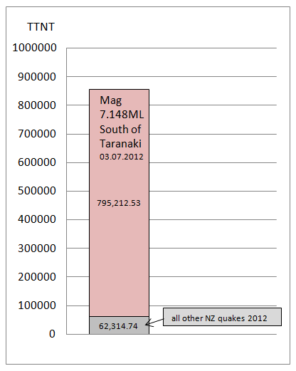
Heres a little one that puts Tuesdays house rattler in perspective. (Geonet still sticking to 7.148ML so far)

Thats getting up there eh
Can't say I noticed it here
At the foot of Pihanga volcanic cone, not far from Rangipo Prison, I wonder if all the alarms went off
edit on 6-7-2012 by muzzy because:
(no reason given)
5.682ML @ 90.8203km deep to be more precise
edit on 6-7-2012 by muzzy because: (no reason given)
Dammit I just updated all my NZ graphs this morning too
Heres a little one that puts Tuesdays house rattler in perspective. (Geonet still sticking to 7.148ML so far)

edit on 6-7-2012 by muzzy because: (no reason given)
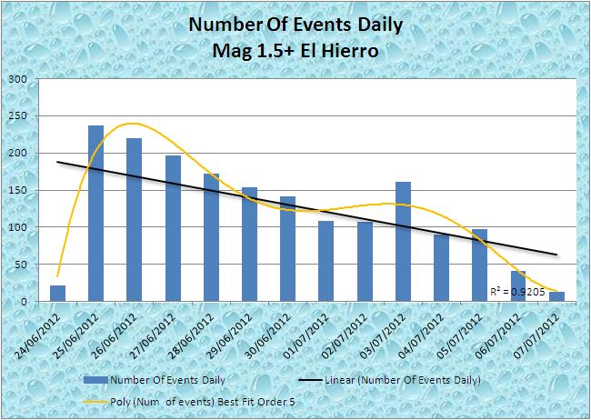
I have just updated my El Hierro page (See my signature).
I have to say that at present I don't see this going anywhere. The trend of the number of events per day just goes down. Looks as if it may be a bit of a non event despite the prognostications of the experts.

I have to say that at present I don't see this going anywhere. The trend of the number of events per day just goes down. Looks as if it may be a bit of a non event despite the prognostications of the experts.

update to post by PuterMan
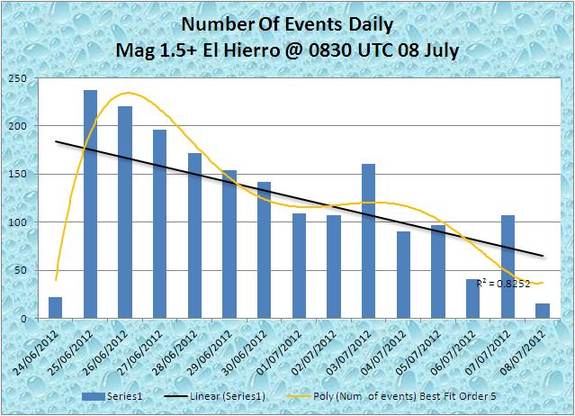
Well just to prove me wrong it woke up again this afternoon - remember this is Mag 2.5+ only
Well just to prove me wrong it woke up again this afternoon - remember this is Mag 2.5+ only
Prov,Date/Time UTC,Latitude,Longitude,Magnitude,Depth(Km),Location
emsc,2012-07-07 05:41:50, 27.691, -18.097, 2.5, 23.0, Canary Isls. Spain Region
emsc,2012-07-07 10:46:38, 27.709, -18.143, 2.5, 21.0, Canary Isls. Spain Region
emsc,2012-07-07 10:51:17, 27.682, -18.166, 2.7, 20.0, Canary Isls. Spain Region
emsc,2012-07-07 11:02:31, 27.844, -18.196, 2.6, 10.0, Canary Isls. Spain Region
emsc,2012-07-07 16:01:51, 27.708, -18.159, 2.5, 20.0, Canary Isls. Spain Region
emsc,2012-07-07 16:28:22, 27.670, -18.130, 3.0, 21.0, Canary Isls. Spain Region
emsc,2012-07-07 16:50:38, 27.673, -18.150, 2.7, 22.0, Canary Isls. Spain Region
emsc,2012-07-07 16:53:55, 27.656, -18.140, 2.5, 20.0, Canary Isls. Spain Region
emsc,2012-07-07 17:28:39, 27.658, -18.140, 2.7, 22.0, Canary Isls. Spain Region
emsc,2012-07-07 17:37:55, 27.652, -18.150, 3.0, 20.0, Canary Isls. Spain Region
emsc,2012-07-07 17:52:18, 27.753, -18.159, 2.6, 22.0, Canary Isls. Spain Region
emsc,2012-07-07 18:04:48, 27.708, -18.159, 2.6, 21.0, Canary Isls. Spain Region
emsc,2012-07-07 18:13:29, 27.669, -18.150, 2.5, 22.0, Canary Isls. Spain Region
emsc,2012-07-07 18:15:36, 27.673, -18.159, 2.7, 21.0, Canary Isls. Spain Region
emsc,2012-07-07 18:21:42, 27.680, -18.149, 2.6, 22.0, Canary Isls. Spain Region
emsc,2012-07-07 18:24:40, 27.698, -18.148, 2.6, 24.0, Canary Isls. Spain Region
edit on 7/7/2012 by PuterMan because: (no reason given)
reply to post by muzzy
Re those "all other NZ quakes" on the graph, I used the 3287 I have saved on file, just did a new download and there are now 3597, which won't change the % all that much
add 5118.5 TTNT for the 5.7 Rangipo 5.7ML to the grey area
Re those "all other NZ quakes" on the graph, I used the 3287 I have saved on file, just did a new download and there are now 3597, which won't change the % all that much
add 5118.5 TTNT for the 5.7 Rangipo 5.7ML to the grey area
new topics
-
Studies show that watching a beaver eat cabbage lowers stress by 17%
Health & Wellness: 2 hours ago -
Salvatore Pais confirms science in MH370 videos are real during live stream
General Conspiracies: 2 hours ago -
Australia passes social media ban for children under 16
Social Issues and Civil Unrest: 5 hours ago -
James Webb Telescope Takes a Look at the Sombrero Galaxy
Space Exploration: 6 hours ago
top topics
-
James Webb Telescope Takes a Look at the Sombrero Galaxy
Space Exploration: 6 hours ago, 10 flags -
Australia passes social media ban for children under 16
Social Issues and Civil Unrest: 5 hours ago, 5 flags -
Salvatore Pais confirms science in MH370 videos are real during live stream
General Conspiracies: 2 hours ago, 3 flags -
Studies show that watching a beaver eat cabbage lowers stress by 17%
Health & Wellness: 2 hours ago, 3 flags
active topics
-
President-Elect Trump Picks Indian-American KASHYAP P. PATEL for F.B.I. Director.
2024 Elections • 38 • : WeMustCare -
Of course it was DEI
Dissecting Disinformation • 25 • : Coelacanth55 -
Salvatore Pais confirms science in MH370 videos are real during live stream
General Conspiracies • 12 • : lostgirl -
Australia passes social media ban for children under 16
Social Issues and Civil Unrest • 6 • : watchitburn -
Assad flees to moscow
World War Three • 39 • : Coelacanth55 -
Elon Musk to Make Games Great Again - XAI_GAMES Announcement Incoming.
Video Games • 22 • : Athetos -
The Reactionary Conspiracy 13. The plot’s theology.
General Conspiracies • 317 • : Solvedit -
I thought Trump was the existential threat?
World War Three • 179 • : Xtrozero -
Studies show that watching a beaver eat cabbage lowers stress by 17%
Health & Wellness • 0 • : gortex -
Feng Shui…
Health & Wellness • 18 • : JJproductions

