It looks like you're using an Ad Blocker.
Please white-list or disable AboveTopSecret.com in your ad-blocking tool.
Thank you.
Some features of ATS will be disabled while you continue to use an ad-blocker.

The Rainbow Serpents
page: 37share:
I just watched a show on the Nazca lines and the scientist believes they are water markers that trace the flow of water underground, and that the
animal symbols are like names for those underground rivers. After watching the show, I believe him..
will you post more of the markings Zorgon? I think it is probably very hard to get the story, but if you do, please share!!
Those Nazca lines, ummm...
I think of as ceremonial mazes. Pilgrimage is a very old tradition, and sites in mesoamerica such as Choco Canyon and the Nazca lines in Peru were originally holy places of pilgrimage for the devout.
I havn't seen that docu you speak of, but my hunch is derived from the gnosis and gnomen of the Throne of Osiris.
I bet lengthy searching will turn up the lines near Pine Gap belonging to the same class.
But I have been wrong before...we'll see!
Those circles are a good catch, especially because we dont have a clue what we are dealing with here
As for the "Pyramid" (zorgon is right, it may not be a pyramid at all): Someone sent me the google coordinates by email. An internet-search revealed that it was first discovered by a film producer by the name of Ian James Colmer.
As for the "Pyramid" (zorgon is right, it may not be a pyramid at all): Someone sent me the google coordinates by email. An internet-search revealed that it was first discovered by a film producer by the name of Ian James Colmer.
whoa nelly............
This guy is in cahoots with this guy
www.brucecathie.com...
Im a freak and hate movies, well miramax trash anyways, but I would pay to see antigravity the movie..
Research this guy, he seems an interesting fellow. Its nuts we just keep going round in circles with this thread.
www.whale.to...
www.dprins.demon.nl...
A few bits of random linkage
Head explosion zone ahead, dont say I didnt warn you..
Dare say the great Mr Zorgon knows of this fellow though
Oh and I like being called a lady, makes me feel old like I have finally come of age, finally.......
[edit on 14-9-2008 by KTK]
[edit on 14-9-2008 by KTK]
[edit on 14-9-2008 by KTK]
I think his theory would still fit with yours, He said that water was very important in their climate, and it would have made sense that they would have mapped the water underground so as to get water when ever they needed it. If they were making pilgrimages they wouldn't have to go in search of water... the map would be right there. He showed how they still clean manmade underground water channels that are very old to this day. Pine gap sounds dry too. Perhaps the Aborigines mapped their water sources too.
Originally posted by Matyas
Those Nazca lines, ummm...
I think of as ceremonial mazes. Pilgrimage is a very old tradition, and sites in mesoamerica such as Choco Canyon and the Nazca lines in Peru were originally holy places of pilgrimage for the devout.
I havn't seen that docu you speak of, but my hunch is derived from the gnosis and gnomen of the Throne of Osiris.
I bet lengthy searching will turn up the lines near Pine Gap belonging to the same class.
But I have been wrong before...we'll see!
I agree that they could be ceremonial as well. I would imagine a great deal of ritual, ceremony and worship surrounded their gods and resources. He
also talked about seashells that were rare to the area being sprinkled in the rock formations. Storms that brought water would bring a certain shell
to the beaches. They obviously collected them and may have believed they were signs from gods or valued them because they came with the much needed
water.
Im thinking harmonics.
They always sing things into existance. Songlines ra ra ra. You see thses patterns on alot of paintings and rock art
There is something to these things and sacred geometry. Its almost like raw science
They always sing things into existance. Songlines ra ra ra. You see thses patterns on alot of paintings and rock art
There is something to these things and sacred geometry. Its almost like raw science
reply to post by KTK
I can't make head nor tails of that...
Now we need a mathmatician, a physicist and a dowser....
Ouch, that hurt...
Head explosion zone ahead, dont say I didnt warn you..
I can't make head nor tails of that...
Now we need a mathmatician, a physicist and a dowser....
reply to post by KTK
That "antenna" was actually proved to be a sponge. Sorry.
I don't put much stock in Bruce's work, nor do I consider him an "expert" in antigravity. He does have entertainment value though.
On sound and harmonics, as with music, I believe there is a strong connection. I see geometry as "solidified" vibration...
Dont stress my gurus dont charge for dots. Just pointing out the relationship of this interesting director fellow and the old duck. Just funny that
they are looking for the same stuff we are, but they are making money from it.
But one thing of his peaked my interest. Theres something about sine waves which I have always proclaimed due to the doppler effect of the bullroarer. The dutch hippy link had a neat o sinewave drawing of how he perceives the nature of atoms. Now he may not be 100% right but there is something in that there muck of diagrams and pseudo science.
I had found a fantastic animated cartoon showing the doppler effect and right there you can see how we can only go so far into the future and past. It quite literally shows the dreamtime and the bubble of cause and effect. Ill keep looking and then i wont seem so crazy
Nazca
David Johnson Dowsing
another source
Johnson's Hypothesis These observations led to a new working hypothesis for the function of the Nasca lines that was different from any previous idea: geological faults and alluvial gravels provide pathways for ground water flow, and they transmit water as a zone of concentrated flow into the valleys. These geological features collect water in one part of the drainage and conduct it across and down the valleys to locations where it can be reached by digging puquios or wells, or to locations where the water table is high enough for springs or seepage to be present on the surface. The ancient people realized they could find a reliable source of fresh water at these locations and that is where they established their habitation sites. Johnson claims the ancient Nasca marked the flow of subterranean water with geoglyphs. He argued that there are five factors that are consistently found together: geological faults and/or higher permeability sands and gravels with the alluvial fans, archaeological sites, an aquifer, a source of fresh water (spring, seep, puquio, or well), and the geoglyphs that mark their location. Where one or more of these features are found there is a high probability the others are present. After Dave returned from Peru in 1996 and explained his hypothesis to me, I recommended that he collaborate with professional geologists since the scientific community would be very skeptical of his findings that were largely based on dowsing. I returned to Peru in 1997 to further investigate the area of my projected surface survey, to reacquaint myself with the area where I had not done field archaeology in almost 35 years, and to consult with colleagues. I again spent the majority of my time with Johnson and volunteers who had joined him. I was able to visit more of the remote parts of the drainage and participated in the discovery of many new geoglyphs which Johnson had a knack for finding. Dave began contacting geologists and hydrologists to participate in the project. He secured funding from the National Geographic Society for his water research in 1998, and I was awarded a grant from the H. John Heinz III trust to undertake my archaeological survey of the lower Nasca and Rio Grande rivers:
David Johnson Dowsing
No, no, never thought you were crazy. Maybe a little touch of madness like me
On second thought, I feel I was a little too harsh on Bruce. He does have some very good information, its just that some of his conclusions are either too outlandish for me or completely bunk.
The "grid" I believe is the flow pattern of telluric currents within the Earth. I also hypothesized they extend out into space, being linked to the Sun, and so forth.
You can tap into these currents by using an old WWI radio trick of nailing an antenna to a tree for a shortwave or am radio. I think it has to be about 2/3rds of the way up, if I am recalling correctly...supposed to boost reception a good deal.
There is a rare hobby called ground radio, where the signals are transmitted through the Earth instead of bouncing around. They bury conductive plates, using them as antennas.
Certainly very fascinating, to say the least. I for one regard the knowledge of the ancients in high esteem.
Wow great stuff everyone - KTK fascinating about the electrons
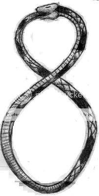
And Seagrass about that snake dream - Here's a little prezzie for ya lol Now don't go bludgeoning these ones to death okay - be nice Sorry I just couldn't resist

[edit on 14-9-2008 by destiny-fate]
"Human beings are accustomed to the fact that if they turn round through 3600 (through a full circle), they find themselves facing in the direction they started from. Not so an electron. By Passing it through a certain type of magnetic field, its ‘axis of spin’ can be tipped through 3600, which ought to restore it to its original position. But it doesn't. The electron has to be turned through yet another full circle before it behaves as it did before. We cannot distinguish the difference between the two circles—the electron can—which seems to suggest that in the subatomic world a full circle is not 360° but 720°. In our world we have somehow lost half the degrees we ought to have. Or to put it another way, there may be another dimension in the subatomic world."
And Seagrass about that snake dream - Here's a little prezzie for ya lol Now don't go bludgeoning these ones to death okay - be nice Sorry I just couldn't resist
[edit on 14-9-2008 by destiny-fate]
Back again
I was sitting thinking about this when I got an image of the figure 8. Two circles joined together - this symbol represents infinity - Alpha and Omega ?? I have no idea where that thought is taking me lol
"Human beings are accustomed to the fact that if they turn round through 3600 (through a full circle), they find themselves facing in the direction they started from. Not so an electron. By Passing it through a certain type of magnetic field, its ‘axis of spin’ can be tipped through 3600, which ought to restore it to its original position. But it doesn't. The electron has to be turned through yet another full circle before it behaves as it did before. We cannot distinguish the difference between the two circles—the electron can—which seems to suggest that in the subatomic world a full circle is not 360° but 720°. In our world we have somehow lost half the degrees we ought to have. Or to put it another way, there may be another dimension in the subatomic world."
I was sitting thinking about this when I got an image of the figure 8. Two circles joined together - this symbol represents infinity - Alpha and Omega ?? I have no idea where that thought is taking me lol
My hunch seems right
en.wikipedia.org...
www.cymatics.org...
Cymatics is the study of wave phenomena. It is typically associated with the physical patterns produced through the interaction of sound waves in a medium.
A simple experiment demonstrating the visualisation of cymatics can be done by sprinkling sand on a metal plate and vibrating the plate, for example by drawing a violin bow along the edge, the sand will then form itself into standing wave patterns such as simple concentric circles. The higher the frequency, the more complex the shapes produced, with certain shapes having similarities to traditional mandala designs.
en.wikipedia.org...
www.cymatics.org...
Some of the elders in the book I have quoted died
digilander.libero.it...
Nice words there
[edit on 15-9-2008 by KTK]
[edit on 15-9-2008 by KTK]
digilander.libero.it...
Nice words there
[edit on 15-9-2008 by KTK]
[edit on 15-9-2008 by KTK]
new topics
-
Sept 17th 2024 - Early Voting Has Begun - Ensure Officials Have Ballot Auditing Measures Installed.
2024 Elections: 6 hours ago -
A couple amazing live performances from two ladies who left us WAY too soon
Music: 8 hours ago -
Cell phones exploding in Lebanon mass casualties
Middle East Issues: 8 hours ago -
Why Donald J Trump is a threat to Democracy and Normal Feedoms
US Political Madness: 8 hours ago -
FBI goes to Ohio - assessing the credibility of threats against Haitians
US Political Madness: 10 hours ago -
UK Channel 4 programme The Trump Heist
Mainstream News: 11 hours ago
top topics
-
Hillary Clinton says Trump poses 'danger to our country and the world' after assassination attempt
US Political Madness: 16 hours ago, 22 flags -
Hillary Attacks Trump One Day After the 2nd Attempt on Him!
US Political Madness: 16 hours ago, 20 flags -
FBI goes to Ohio - assessing the credibility of threats against Haitians
US Political Madness: 10 hours ago, 14 flags -
Sean Diddy Combs Charged with Sex Trafficking and Racketering in NYC
Mainstream News: 17 hours ago, 10 flags -
I need some Wisdom and Understanding .
Philosophy and Metaphysics: 15 hours ago, 7 flags -
Why Donald J Trump is a threat to Democracy and Normal Feedoms
US Political Madness: 8 hours ago, 5 flags -
Sept 17th 2024 - Early Voting Has Begun - Ensure Officials Have Ballot Auditing Measures Installed.
2024 Elections: 6 hours ago, 5 flags -
China UFO September 16, 2024
Aliens and UFOs: 14 hours ago, 4 flags -
A couple amazing live performances from two ladies who left us WAY too soon
Music: 8 hours ago, 4 flags -
UK Channel 4 programme The Trump Heist
Mainstream News: 11 hours ago, 4 flags
active topics
-
Hundreds of Hezbollah members injured in Lebanon when the pagers they used to communicate exploded
Middle East Issues • 97 • : Owlwatcher -
The Brink has been reached.
World War Three • 164 • : UKTruth -
Hillary Clinton says Trump poses 'danger to our country and the world' after assassination attempt
US Political Madness • 42 • : coldisbest118 -
Over 1,100 Migrants Arrived in First 10 Days of Labour Government
Social Issues and Civil Unrest • 358 • : gortex -
tweeting nasty words worse than child porn according to judges and the Labour party
Social Issues and Civil Unrest • 38 • : Dalamax -
I need some Wisdom and Understanding .
Philosophy and Metaphysics • 25 • : BingoMcGoof -
Cell phones exploding in Lebanon mass casualties
Middle East Issues • 22 • : annonentity -
2024 Election - Americans Will Choose either 2018 Republicans -or- 2022 Democrats.
2024 Elections • 18 • : WeMustCare -
The UK collapsing fast
Science & Technology • 229 • : SecretKnowledge2 -
A couple amazing live performances from two ladies who left us WAY too soon
Music • 11 • : BingoMcGoof