It looks like you're using an Ad Blocker.
Please white-list or disable AboveTopSecret.com in your ad-blocking tool.
Thank you.
Some features of ATS will be disabled while you continue to use an ad-blocker.
share:
a reply to: cooperton
As to your idea that cave paintings show dino's, again thats just opinion and not scientific evidence.
Medieval drawing of animals are mostly interpretation or artistic licence, that doesn'y mean they all actually looked like that...
www.bing.com...
As to your idea that cave paintings show dino's, again thats just opinion and not scientific evidence.
Medieval drawing of animals are mostly interpretation or artistic licence, that doesn'y mean they all actually looked like that...
www.bing.com...
edit on 17-12-2023 by Kurokage because: (no
reason given)
originally posted by: cooperton
originally posted by: Kurokage
a reply to: cooperton
The report is from newgeology.us which is a religious wesite pretending to be scientific and failing...
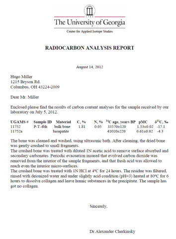
The researchers themselves didn't do the actual carbon-dating. The AMS data was from the University of Georgia, an accredited lab:
Do you have any evidence to support your assertion besides appeals to authority and character assassination? We should be excited at new results that change paradigms! The same spirit that persecuted Galileo is the same dogma that is currently defending the mutant ape theory.
Yet no link to the actual paper??
edit on 17-12-2023 by Kurokage because: (no reason given)
originally posted by: Kurokage
a reply to: cooperton
As to your idea that cave paintings show dino's, again thats just opinion and not scientific evidence.
Let's post it here for others to consider. Sometimes children are best to identify these without bias. It is amazing how as adults we look past the obvious to maintain what we were told our whole life:
Brachiosaurus
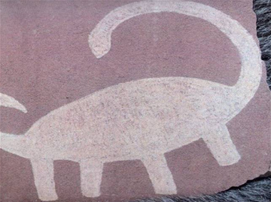
Utah's White Canyon Region
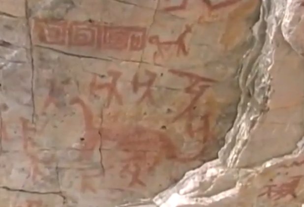
Amazon Rain Forest Basin in Northern Peru

El Toro Mountain part of the "Acambaro Figurine" collection found by Waldemar Julsrud
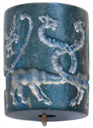
Mesopotamian Cylinder Seal of Uruk currently housed in the Louvre
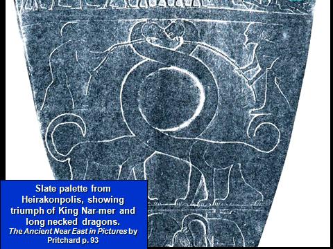
Housed at the British Museum
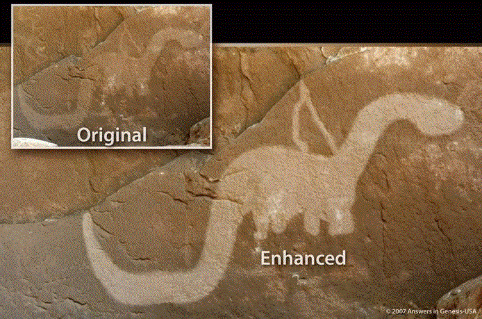
By the North American Anasazi in the area now known as Utah. A natural brownish film over top the cave drawing authenticates its age.

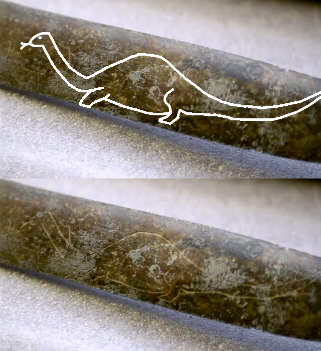
A mysterious excavation in Tucson Arizona unearthed 31 Roman-style artifacts. One of which was this sword.
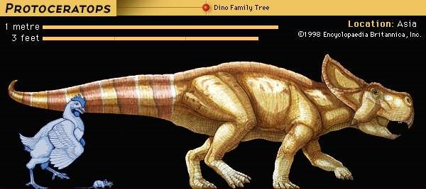
Protoceratops
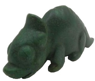

Hongshan carvings approximately 4,000 years ago China
It is also important to note that the average dinosaur was approximately the size of a full grown dog.
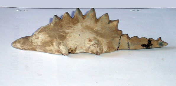
Stegasaurus
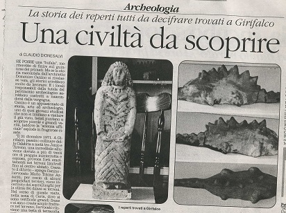
Girifalco region of Southern Italy.
Tyranosaurus Rex

Holy Trinity Church built in the 1300s in the country of Georgia.
These dinosaurs are not limited to physical depictions. They have also been written about. Extensively. Here is a beast from Beowulf, the Anglo-Saxon Epic:
"Grendel's swift hard claws
snatched at the first Geat
He came to, ripped him apart, cut
His body to bits with powerful jaws,
Drank the blood from his veins and bolted
Him down, hands and feet; death
And Grendel's great teeth came together,
Snapping life shut."
"but their weapons
Could not hurt him,
the sharpest and hardest iron
Could not scratch at Grendel's skin"
“The fiend reached for him with his claw, but he grasped it with set purpose, and
threw his weight on Grendel’s arm.”
This creature had huge jaws that could devour people whole, was bipedal with arms, and tough skin. This quite accurately describes a tyrannosaurus rex, or more accurately the Megalosaurus which fossils have been found in the Anglo-Saxon area. In Beowulf, Grendel, which means “to Below” (like you would imagine a T-rex-like creature would), even had a mother of the same kind, insisting it was a real biological creature.
Sometimes children are best to identify
So children are now scientific experts are they? Maybe thats why you believe in these myths?
edit on 17-12-2023 by Kurokage because: (no reason
given)
originally posted by: Kurokage
So children are now scientific experts are they? Maybe thats why you believe in these myths?
Do you really need a peer-reviewed study to show you that this is a stegasaurus?

I was pointing out the irony that a child would be better fit to identify what they are seeing than those who have such immense bias they avert their eyes from the obvious
edit on 17-12-2023 by cooperton because: (no reason given)
originally posted by: cooperton
originally posted by: Kurokage
So children are now scientific experts are they? Maybe thats why you believe in these myths?
Do you really need a peer-reviewed study to show you that this is a stegosaurus?
How is it a stegosaurus? I see you're posting from Genisis park. Try lookingh for the original pic?
originally posted by: Kurokage
How is it a stegosaurus? I see you're posting from Genisis park. Try lookingh for the original pic?
That's what I am saying, ask a child to identify what this figurine obviously is. Here is the newspaper report on the finding:

"The “Sauro di Girifalco” (Girifalco's saurus) is a mysterious sculpture that challenges all current knowledge on the dynamics of mankind's historical and cultural heritage." link
edit on
17-12-2023 by cooperton because: (no reason given)
a reply to: cooperton
It's kinda funny that the ultimate revenge story in theological literature directly contributes to the present day "climate crisis" which (allegedly) threatens our society. No flood, no oil, no carbon footprint.
All part of the plan, I suppose.
It's kinda funny that the ultimate revenge story in theological literature directly contributes to the present day "climate crisis" which (allegedly) threatens our society. No flood, no oil, no carbon footprint.
All part of the plan, I suppose.
edit on 17-12-2023 by TzarChasm because: (no reason given)
a reply to: cooperton
The Younger Dryas events sums up everything almost perfectly. The sequence is the only question.
It’s said there were a series of cataclysms ranging from roughly 12,800 years ago, until 11,600 years ago.
I’m of the belief that it was an asteroid and / or massive solar flare. Why not both since we have multiple events?
The worldwide flood happened in that time period. All it would take is a decent size asteroid to hit one of our oceans to make it happen. No extra water from below the surface needed. If anyone has done research on this, they’d know it’s absolutely possible.
I believe dinosaurs were already going extinct by the time the Younger Dryas came - but some species still alive. However, it was their final undoing.
Great thread! 🍻
edit on 17-12-2023 by KKLOCO because: (no reason given)
a reply to: cooperton
I would have thought our understanding of the Earth's geological processes and the formation of oil deposits contradicts the notion of a recent global flood.
With the scientific consensus that supports the understanding the Earths geological features and the formation of oil deposits are the result of gradual processes occurring over millions of years, rather than a single catastrophic event like a global flood.
originally posted by: Ohanka
What happened to all the flood water then?
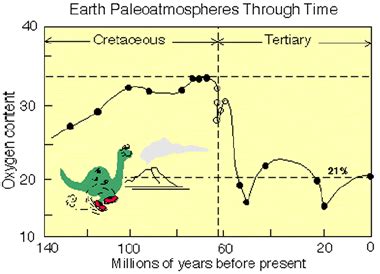
No additional water was added. Just the oceans being forced out of their beds, over washing the continents. That is one type of flood, the last, the Great Flood.
There has been added water floods over the last 70 million years. 3 major ones as indicated by the lowered oxygen content.
a reply to: cooperton
For what it is worth, you are somewhat challenging for a creationist position.
The Potassium/Argon thing is just part of a false dilemma turned false comparrison. Sure it gives an erroneous reading, but there are other explanations not concluding the "Earth is young".
And just because it failed, doesn't mean other methods aren't valid.
U/Pb is WAY more accurate:
For Paleozoic rock, like that in question in the Appalachian Mountains, the margin of error is around .5 to 1%, so you need faith that it's wrong over 99% of the time.
Another false dilemma. Just because they were created rather quickly (in Geological terms), doesn't mean it didn't happen 270-380 MYA, when conditions were more favorable.
Checks out.
The Appalachian Mountains are old. Way older than The Rockies.
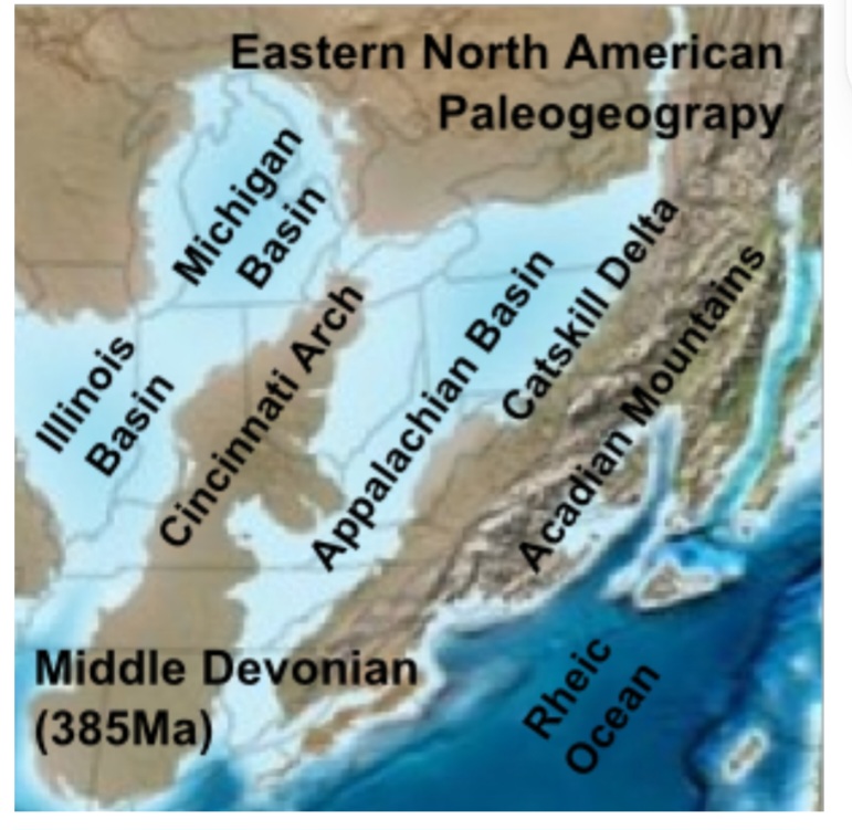
So yes they were created relatively 'quickly', but if you don't acknowledge continental drift, rift basins, uplift, higher levels of sediment, and the millions of years it all took to take its present appearance, you're kinda pulling from a pseudoscientific disadvantage.
Yes, it looks like that now.
Bonus:
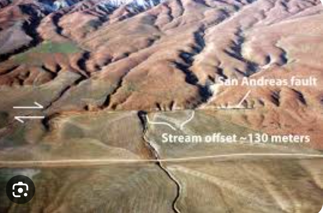
This is The San Andreas Fault. It slips 22mm a year at the spot pictured.
2.2 centimeters a year, 13,000 centimeters of noted slip. That's about 5,900 + years (at average rate).
And that is just one example. I used a 6000 year example purposely, because what else happened in that 6000 years of slip?
Not much.
Locally, I can go to Mission Trails at 400 feet of elevation and find seashells. 1 million years ago the coastline followed somewhere close to I-15, many miles from the coast, much higher ocean level.
It is an ocean level we can plot fairly accurately over time.
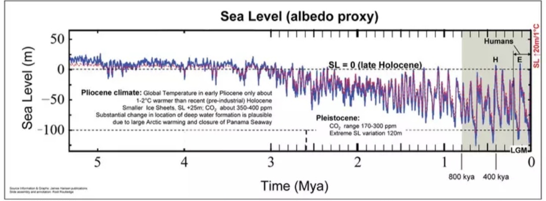
All around me are indications of age. All the canyons between Mesas (former seafloor) were created as the sea level fell and cut out the topography of my city.
There's no dispute. In 6000 years the sea level has fallen two meters. That's not enough to create canyons and leave seashells at Mission Trails for me to find.
Can you explain it in a creationist time frame?
Though I will say it is ambitious to use geology to try to DISPUTE the Earth's age.
For what it is worth, you are somewhat challenging for a creationist position.
The unfortunate thing with a lot of geological claims like this is that they simply have no way of certainly knowing these dates. They can't even properly date fresh volcanic rock, let alone rock that is 100 million years old.
The Potassium/Argon thing is just part of a false dilemma turned false comparrison. Sure it gives an erroneous reading, but there are other explanations not concluding the "Earth is young".
A number of processes could cause the parent substance to be depleted at the top of the magma chamber, or the daughter product to be enriched, both of which would cause the lava erupting earlier to appear very old according to radiometric dating, and lava erupting later to appear younger.
And just because it failed, doesn't mean other methods aren't valid.
U/Pb is WAY more accurate:
Uranium-Lead (U-Pb) dating is the most reliable method for dating Quaternary sedimentary carbonate and silica, and fossils particulary outside the range of radiocarbon. Quaternary geology provides a record of climate change and geologically recent changes in environment. U-Pb geochronology of zircon, baddelyite, and monazite is used for determining the age of emplacement of igneous rocks of all compositions, ranging in age from Tertiary to Early Archean.
the uranium–lead method has an error margin of less than 0.1% for Proterozoic, and 2%–5% for Mesozoic
For Paleozoic rock, like that in question in the Appalachian Mountains, the margin of error is around .5 to 1%, so you need faith that it's wrong over 99% of the time.
They permeate through multiple strata of geological layers though, if that layered effect we see in areas like the Appalachian mountain has a tree sticking through it then it is very obvious that the layer formed quickly. There's no good reason to support the millions of years hypothesis, these formations can occur quickly after a cataclysm.
Another false dilemma. Just because they were created rather quickly (in Geological terms), doesn't mean it didn't happen 270-380 MYA, when conditions were more favorable.
Upright fossils typically occur in layers associated with an actively subsiding coastal plain or rift basin
Checks out.
In the early part of the Carboniferous, during the Mississippian Period, crustal plates were pulling apart in the northern Appalachian Mountains of eastern North America. This resulted in the formation of several basins separated by highlands. These basins filled with non-marine sediments that include sandstones, siltstones, and coals, through the Late Carboniferous, or Pennsylvanian, and into the Early Permian. The rapid rate of deposition of these sediments can be observed in the 4000m section of Pennsylvanian strata around Joggins, Nova Scotia.
The Appalachian Mountains are old. Way older than The Rockies.

The third mountain-building event was the Acadian orogeny which occurred between 375 and 359 million years ago.[28] The Acadian orogeny was caused by a series of collisions of pieces of crust from the Avalonia Terrane, sections broken off from continent of Gondwana, with the North American Plate. The collision initiating this orogeny resulted in the closing of the southern Iapetus ocean and the formation of a high mountain belt. After the Acadian collision took place, Gondwana began to retreat from Laurentia with the newly accreted Avalonian terranes left behind. As Gondwana moved away, a new ocean opened up, the Rheic Ocean, during the Middle to Late Devonian, and subsequently its closure would result in the formation of the Alleghanian orogeny.
So yes they were created relatively 'quickly', but if you don't acknowledge continental drift, rift basins, uplift, higher levels of sediment, and the millions of years it all took to take its present appearance, you're kinda pulling from a pseudoscientific disadvantage.
Yes, it looks like that now.
Bonus:

This is The San Andreas Fault. It slips 22mm a year at the spot pictured.
2.2 centimeters a year, 13,000 centimeters of noted slip. That's about 5,900 + years (at average rate).
And that is just one example. I used a 6000 year example purposely, because what else happened in that 6000 years of slip?
Not much.
Locally, I can go to Mission Trails at 400 feet of elevation and find seashells. 1 million years ago the coastline followed somewhere close to I-15, many miles from the coast, much higher ocean level.
It is an ocean level we can plot fairly accurately over time.

All around me are indications of age. All the canyons between Mesas (former seafloor) were created as the sea level fell and cut out the topography of my city.
There's no dispute. In 6000 years the sea level has fallen two meters. That's not enough to create canyons and leave seashells at Mission Trails for me to find.
Can you explain it in a creationist time frame?
Though I will say it is ambitious to use geology to try to DISPUTE the Earth's age.
edit on 17-12-2023 by Degradation33 because: (no reason given)
originally posted by: BeyondKnowledge3
a reply to: cooperton
But organic material floats. How did it get under the mud if it was deposited in a general all over flood? It would have settled at or near the top of the mud.Where did the mud come from in the volume needed for this to occured? Were there mountains ten miles high all over the contents before the great flood?
Just asking.
Next time you go for a swim, breathe all the air out of your lungs and try and float.
Even with your lungs fully aspirated, you still have a bit of air there, but if your lungs were filled with water, you wouldn't float.
MUD
An exploration of one of Earth's most ubiquitous substances.
Discussions like this are what have me convinced the majority of humanity has NO imagination and lacks the ability to put together basic facts.
Athism/evolution has rotted peoples brains and they can't see basic facts before them.
The flood WAS world wide... Everest is the tallest mountain but still has seashells on its peak!!!(and sediment rock) testifying it was at one point in history, under water....
The world was originally created to be perfect for life. God wouldn't not have wasted space by creating a planet covered by 75% water which is 2 miles deep(with a lot of wasted space in the oceans) and the last 25% has only 3% used by humans as a lot isn't habitable. You use no imagination when discussing where the water went.... its still here on the surface! it just pooled into what is the the oceans today, pushing the ocean floor down and the continents which had less dense rock, pushed up. Get any globe and look at the crack in the middle of the Atlantic. this is the scar left over from the planet breaking up and the water coming out.
The original creation of the world, based on the description given in genesis, would have had much shallower oceans, land would have covered much more of the planet with mountains not as high. There would have been a layer of water around the earth(like a bubble) which pushed down on the atmosphere making it much denser.. causing everything to grow larger. this denser atmosphere is seen in deep antarctic ice pulled to the surface and bubble trapped in amber. This atmosphere would have gone out much higher(creation museum models put this layer out about 200-300 miles above the surface of the earth.) this water layer was VERY important, not only did it move heat from the sun evenly around the earth(blow some bubbles in sunlight and watch what happens) causing very temperate weather at the poles(as seen in archeological digs). But it also would filter out several of the bands of radiation that get through today which cause accelerated aging.... people/animals used to live much longer.
Upon whatever caused the earth to split from pole to pole, the water under pressure would have shot up into what we consider space today popping the bubble and bringing that water down as rain for the 40 days and nights... but the majority of the water came from the depths. with the tectonic plates now broken up, you had extreme underwater volcanoes going off causing wave after wave of sediment to get laid down.
The organic material you claim would float only does so for a few weeks. It gets waterlogged and sinks eventually and would have been covered by the sediment of the flood and the many under water volcanoes going off.
Eventually the planet would have settled down from the shock of whatever broke the planet apart... the weight of the water would have pushed down and continents(which have deep granite bases) rose up causing dry land to appear after about a year. This left behind miles of sediment in layers with no erosion between. I mean, come on... anyone ever go outside and look at what erosion does? it definitely DOESN'T leave nice smooth layers... it hollows out softer rock leaving VERY jagged layers. The only things that lays down sediment in the way we see in nature is a flood.
i still cant believe people look at tree trunks sitting THROUGH multiple layers of sediment which they claim is 100's of millions of years but believe the tree trunk stood upright though it all....the sheer foolishness of this is beyond all logic. meanwhile, just looking at the eruption of Mt. saint hellens in 1981, we have perfect scientific models DEMONSTRATED to back up what kind of damage we should have seen from the flood, what it did to plant life, how sediment got laid down,ect.
a reply to: SpeedRacer2023
Limestone, not seashells like at the beach, there is limestone at 29,000 feet. Limestome with tiny invertibrate fragments in it. Not like you can pick them up.
Limestone requires water. But, you're sorta missing something...
Once upon a time the plate that contained the India Subcontinent broke off from Africa (like what is currently happening along The East African Rift) and migrated across the Indian ocean and slammed into Asia and uplifted Mt Everest from the sea floor. This pushed all the Ordovician limstone to the very top.
This is still happening at 1 mm a year. In 1000 years Mt. Everest will be 1 meter taller! In 1 Million years, assuming consistent rate, its will be 1 km taller! This process called uplift... this process called uplift... *sigh*
Oh screw this, I don't want to play anymore.
Yes, it always existed that way, for ALL 6000 years of existence, and things never move, and there's enough water to cover up to 29,000 feet, and then disappear! There's no other explanation. Pixie dust, fairies, I dream of genie, rainbows, unicorns, and magic.
A shame I have spent my adult life learning about horrible lies like 'plate techtonics' and 'mountain uplift'. Once in school, and from then on for fun.

And I'm a deist that is an ordained universalist minister (I filled out an online form), only my Supreme Being resides in the acausality of physical laws. Kinda postmodern.
Discussions like this are what have me convinced the majority of humanity has NO imagination and lacks the ability to put together basic facts. Athism/evolution has rotted peoples brains and they can't see basic facts before them.
The flood WAS world wide... Everest is the tallest mountain but still has seashells on its peak!!!(and sediment rock) testifying it was at one point in history, under water....
Limestone, not seashells like at the beach, there is limestone at 29,000 feet. Limestome with tiny invertibrate fragments in it. Not like you can pick them up.
Called the "Qomolangma Limestone" by geologists, the summit rocks are well-bedded limestone (grainstone) with fragments of common Ordovician marine invertebrate shells, such as trilobites, brachiopods, ostracods and crinoids.
Limestone requires water. But, you're sorta missing something...
Once upon a time the plate that contained the India Subcontinent broke off from Africa (like what is currently happening along The East African Rift) and migrated across the Indian ocean and slammed into Asia and uplifted Mt Everest from the sea floor. This pushed all the Ordovician limstone to the very top.
The Eurasian plate was partly crumpled and buckled up above the Indian plate but due to their low density/high buoyancy neither continental plate could be subducted. This caused the continental crust to thicken due to folding and faulting by compressional forces pushing up the Himalaya and the Tibetan Plateau.
This is still happening at 1 mm a year. In 1000 years Mt. Everest will be 1 meter taller! In 1 Million years, assuming consistent rate, its will be 1 km taller! This process called uplift... this process called uplift... *sigh*
Oh screw this, I don't want to play anymore.
Yes, it always existed that way, for ALL 6000 years of existence, and things never move, and there's enough water to cover up to 29,000 feet, and then disappear! There's no other explanation. Pixie dust, fairies, I dream of genie, rainbows, unicorns, and magic.
A shame I have spent my adult life learning about horrible lies like 'plate techtonics' and 'mountain uplift'. Once in school, and from then on for fun.

And I'm a deist that is an ordained universalist minister (I filled out an online form), only my Supreme Being resides in the acausality of physical laws. Kinda postmodern.
edit on 18-12-2023 by Degradation33 because: (no reason given)
originally posted by: Degradation33
Limestone requires water. But, you're sorta missing something...
Once upon a time the plate that contained the India Subcontinent broke off from Africa (like what is currently happening along The East African Rift) and migrated across the Indian ocean and slammed into Asia and uplifted Mt Everest from the sea floor. This pushed all the Ordovician limstone to the very top.
That is your belief, but what is the evidence for that besides marine fossils? Marine fossils and limestone present on top of Everest would also be indication of a flood that reached those heights. It's easier for water to rise than mountains to emerge out of the ocean. There's no good empirical evidence to say Everest was at sea level, besides the marine fossils, which are more indicative of a flood.
This is still happening at 1 mm a year. In 1000 years Mt. Everest will be 1 meter taller! In 1 Million years, assuming consistent rate, its will be 1 km taller! This process called uplift... this process called uplift...
A shame I have spent my adult life learning about horrible lies like 'plate techtonics' and 'mountain uplift'. Once in school, and from then on for fun.
Lemme guess, purely theoretical and no empirical data to support this is actually happening?
And I'm a deist that is an ordained universalist minister (I filled out an online form), only my Supreme Being resides in the acausality of physical laws. Kinda postmodern.
Do you think this Supreme Being is too weak to do what our ancestors unanimously said was done?
edit on 18-12-2023 by cooperton because: (no
reason given)
Uranium-Lead (U-Pb) dating is the most reliable method for dating Quaternary sedimentary carbonate and silica, and fossils particulary outside the range of radiocarbon. Quaternary geology provides a record of climate change and geologically recent changes in environment. U-Pb geochronology of zircon, baddelyite, and monazite is used for determining the age of emplacement of igneous rocks of all compositions, ranging in age from Tertiary to Early Archean.
the uranium–lead method has an error margin of less than 0.1% for Proterozoic, and 2%–5% for Mesozoic
This is like when they say humans and chimps are 99% similar. They are merely referring to the parts that match, and in actuality humans have 4% less genetics than chimps, making this 99% claim immediately absurdist. It is the same with these claims about Uranium-Lead dating's accuracy... The reason is because there is no way to certainly know the initial concentration of these isotopes! Without knowing the initial concentration (initial amount) of the isotopes, you cannot properly solve for time in the half-life equation:

They get the dates they want by calibrating the initial concentration to make it seem as though it is older, based merely off the speculation that it must be old because evolution must be true. You'd be SHOCKED at the broken merry-go-round of logic that is the reasoning for evolutionary theory. So I could use the same logic, and speculate that our ancestors were correct on their timing of historical events, and calibrate the initial concentration of these geological isotopes and it would appear I am correct.
edit on 18-12-2023 by cooperton because: (no reason given)
originally posted by: andy06shake
a reply to: cooperton
I would have thought our understanding of the Earth's geological processes and the formation of oil deposits contradicts the notion of a recent global flood.
With the scientific consensus that supports the understanding the Earths geological features and the formation of oil deposits are the result of gradual processes occurring over millions of years, rather than a single catastrophic event like a global flood.
this research shows it can happen quickly with high pressure, which would have been exhibited during and and after the flood subsided. It happens within hours, and does not require millions of years.
a reply to: cooperton
From your own article cooperton.
Just because Science has discovered how to artificially create crude oil in such a short span of time does not mean that's how nature does nor does it negate our understanding of the Earth's geological processes.
From your own article cooperton.
In nature, crude oil is the product of hundreds of species of algae and bacteria that grew, died, and slowly settled to form deposits of decaying organic matter.
Just because Science has discovered how to artificially create crude oil in such a short span of time does not mean that's how nature does nor does it negate our understanding of the Earth's geological processes.
new topics
-
Don't cry do Cryo instead
General Chit Chat: 32 minutes ago -
Tariffs all around, Except for ...
Predictions & Prophecies: 2 hours ago -
Gen Flynn's Sister and her cohort blow the whistle on DHS/CBP involvement in child trafficking.
Whistle Blowers and Leaked Documents: 7 hours ago -
Anybody else using Pomodoro time management technique?
General Chit Chat: 10 hours ago
top topics
-
Trump sues media outlets -- 10 Billion Dollar lawsuit
US Political Madness: 13 hours ago, 24 flags -
Bucks County commissioners vote to count illegal ballots in Pennsylvania recount
2024 Elections: 12 hours ago, 21 flags -
How long till it starts
US Political Madness: 15 hours ago, 17 flags -
USSS Agent Fired for Having Sex In Michelle Obama's Bathroom
Politicians & People: 16 hours ago, 10 flags -
Fired fema employee speaks.
US Political Madness: 13 hours ago, 10 flags -
Gen Flynn's Sister and her cohort blow the whistle on DHS/CBP involvement in child trafficking.
Whistle Blowers and Leaked Documents: 7 hours ago, 8 flags -
Anybody else using Pomodoro time management technique?
General Chit Chat: 10 hours ago, 3 flags -
Tariffs all around, Except for ...
Predictions & Prophecies: 2 hours ago, 1 flags -
Don't cry do Cryo instead
General Chit Chat: 32 minutes ago, 1 flags
active topics
-
Tariffs all around, Except for ...
Predictions & Prophecies • 8 • : sonofred -
Don't cry do Cryo instead
General Chit Chat • 0 • : 727Sky -
President-Elect DONALD TRUMP's 2nd-Term Administration Takes Shape.
Political Ideology • 205 • : WeMustCare -
On Nov. 5th 2024 - AMERICANS Prevented the Complete Destruction of America from Within.
2024 Elections • 155 • : WeMustCare -
Mike Tyson returns 11-15-24
World Sports • 53 • : Blueracer -
The Trump effect 6 days after 2024 election
2024 Elections • 143 • : cherokeetroy -
Bucks County commissioners vote to count illegal ballots in Pennsylvania recount
2024 Elections • 21 • : Irishhaf -
60s-70s Psychedelia
Music • 54 • : gort69 -
The art of being offended
Social Issues and Civil Unrest • 49 • : gort69 -
Gen Flynn's Sister and her cohort blow the whistle on DHS/CBP involvement in child trafficking.
Whistle Blowers and Leaked Documents • 6 • : gort69

