It looks like you're using an Ad Blocker.
Please white-list or disable AboveTopSecret.com in your ad-blocking tool.
Thank you.
Some features of ATS will be disabled while you continue to use an ad-blocker.

Crashed Flying Saucer on Mars?--Sure Looks Like it!
page: 7share:
a reply to: neutronflux
To be fair, it may not be a question of ignoring it, more a question of it not being available - it least not in high enough resolution.
This is a good source for Martian data
ode.rsl.wustl.edu...
India's data isn't of high enough quality to reveal anything. China's data is available, but their map search isn't working for me:
moon.bao.ac.cn...
The Emirates' Hope probe has data, but requires registration, thought might be accesdible through the JMARS application.
jmars.asu.edu...
edit on 14/12/2021 by OneBigMonkeyToo because: added link
a reply to: OneBigMonkeyToo
I guess it’s not really A survey as in for metals, but here is this?
Or this?
I guess it’s not really A survey as in for metals, but here is this?
Mars Reconnaissance Orbiter: Mapping Mars in High Definition
www.space.com...
MRO sent a high-resolution picture not only showing the rover and its tracks, but also a shadow cast by the golf-cart sized vehicle on Mars.
Or this?
Curiosity and Rover Tracks at 'the Kimberley,' April 2014
mars.nasa.gov...
NASA's Curiosity Mars rover and tracks from its driving are visible in this view from orbit, acquired on April 11, 2014, by the High Resolution Imaging Science Experiment (HiRISE) camera on NASA's Mars Reconnaissance Orbiter.
a reply to: OneBigMonkeyToo
Darn earth man littering Mars with space junk not even the proper saucer shape. It’s like they evolved from primates or something….
Darn earth man littering Mars with space junk not even the proper saucer shape. It’s like they evolved from primates or something….
I think the object may actually be airborne and not crashed at all. If you were going to have any type of base/civilization on mars it would almost
certainly be underground given the Martian climate and how obviously a “Base” would stick out like a sore thumb.
The “crashed flying saucers” idea is just a way of framing context and narrative that fits what people believe to be “reality”.
A reality sufficiently different than the one you live in would be perceived as fantasy.
There are humans on Earth, right now, living a personal reality that is your fantasy.
Given that’s true - the reality of a base on Mars might seem like fiction to you but could be a very real, normal occurrence that’s no more novel to some than your going to the grocery store.
I say all of that to suggest keeping a very open mind here and not to let your individual take on what reality is limit you to only seeing what your reality is - there is a lot more to reality than what some think there is.
originally posted by: penroc3
if you slow a movie down its just pictures
I know that, obviously.
they have a sequence of images taken over a period of time that shows the salty water coming out of some dune
That's what I have seen.
Saying there's a video of liquid water makes people think of a real video, with several frames per second, not of 4 or 5 images taken several days/months apart.
originally posted by: neutronflux
This circular stone has nothing to do with circles in nature? By all means. Please show how the circular “object” on mars is more perfect and not stone.
I don't see any circular object on the photos, only a crescent shaped dune at the end of the trench.
By the way. It’s seems my question was ignored on how corresponding surveys of the area by radar and ultraviolet for example support the question of this thread? Or don’t support the question of this thread….
Not ignored, I was looking for an answer.

But I haven't found any photo not taken with that red filter of that specific area.
What I do know is that, usually, non-visible wavelengths photos have a lower resolution, as does radar or laser altimetry, so even if there are other photos from other types of instruments, I don't expect them to have a high enough resolution to shows us this area in detail.
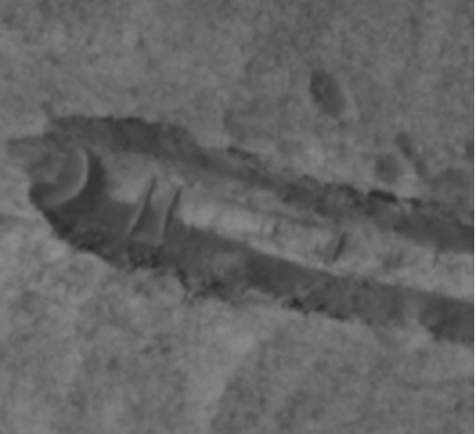
The more I look at it the more it looks like a collapsed lava tube, although that region does not look volcanic.
Here's an animation that may help get an idea of how it looks in 3D.
Here's an animation that may help get an idea of how it looks in 3D.
originally posted by: ArMaP
The more I look at it the more it looks like a collapsed lava tube, although that region does not look volcanic.
Here's an animation that may help get an idea of how it looks in 3D.
It looks like a symmetrical cylinder in the middle that’s about 80-90% buried.
This well might have started life as a collapsed tube, small canyon or other natural occurring indentation in the planet’s surface. I doubt it’s a skid mark from a crashed saucer.
That said, I kind of imagine this would be a perfect place to build some sort of underground facility. Why? You get natural protection (at least to some degree) from wind and sand storms.
a reply to: ArMaP
One other addition:
To me, cases like this come down to perception of what’s “real” or are things that “could be real” actually reality.
Almost all could agree It’s an interesting picture that contains something that has a non-zero probability of being an object.
Beyond that?
Well, our government takes UAPs seriously and flying disks have a history both in lore and bordering on some realities - so the crashed disk theory could have a place in generally agreed upon reality.
Now, what if the lens you’re viewing this through - agreed upon reality - isn’t entirely complete?
Let’s say that true reality is we have people on Mars and have for a long time. We’ve encountered other life, we build our spacecraft and black projects there, we can travel there relatively easily (say 12 hours max) and we have vehicles that can transport black project tech back to earth.
If that’s reality, then we may be looking at a craft in flight entering a “hangar” of sorts in a depressed valley. Not crashed, functioning - and the “reconnaissance” orbiter could have been snapping pictures of this area for surveillance.
Might sound crazy but remember… your reality is more-less what you engage with every day. You might be aware of other things but think of the billionaires of the world - most of your wildest dreams are things they could make reality - which isn’t your reality.
Everything NASA has told us is an explanation of officially acknowledged reality - doesn’t mean that’s actually the case.
a reply to: IAMTAT
Considering the location, within the Valles Marinaris, it looks a lot like a trench dug out by something being dragged along the surface underwater. This region most certainly had a high flowing area of water at one point in the planet's history.
This looks very similar to what happens in Lake Michigan when the ice flows over a shallower area, usually up around Beaver Island and the Straits of Mackinac. The ice scrapes the surface of the lake bottom, digging up trenches as it goes along.
originally posted by: ArMaP
The more I look at it the more it looks like a collapsed lava tube, although that region does not look volcanic.
Here's an animation that may help get an idea of how it looks in 3D.
Looks like a trench, but I think the depth is misleading?
I don't think it's a lava tube, not enough debris in the "trench" to assume a collapse, more of a inflow of finer wind-blown material.
Also, where's the outflow?
a reply to: gspat
I've been trying to get a 'z' coordinate from the GIS package, but it won't let me! I can tell you that the 'trench' (or whatever we want to call it) is about 13-14m wide, 345m long, and the walls have about 5m in vertical drop. The sides are steep but not vertical. I'd agree that the 3D image by ArMaP does look to exaggerate that depth, but that said my 3D model is relying on the underlying DEM being accurate!
You pays your money...
a reply to: gspat
sand and dirt on mars acts differently than on earth due to the super low air pressure on mars with out some sort of suit you would die in seconds on mars from decompression and toxic gas levels.
200mph windstorms on mars wouldn't even knock a fully grown man to his feet.
this impact hit ancient ground that is surly compacted already and maybe even rock.
it looks like something either slid down the mountain like a land slide or a incoming low angel meteorite hit really shallow and almost looks to have bounced a but before coming to a rest
so the rock or sand could have been flung very very far or straight up and would follow that path pretty much unrestricted or hindered by a thick atmosphere like on earth
or we are seeing something we want, that so called trench could infarct be a raised feature but i don't think it is.
my guess is a shallow meteorite or landslide off that mountain
Interesting photo, but my first thought was a meteorite.
Just like it happens here on Earth.
Just like it happens here on Earth.
originally posted by: VulcanWerks
If that’s reality, then we may be looking at a craft in flight entering a “hangar” of sorts in a depressed valley. Not crashed, functioning - and the “reconnaissance” orbiter could have been snapping pictures of this area for surveillance.
Not very likely that the "craft" was entering the "hangar" in the exact same position at two different occasions.
And it doesn't look anything like that to me.
originally posted by: ArMaP
originally posted by: VulcanWerks
If that’s reality, then we may be looking at a craft in flight entering a “hangar” of sorts in a depressed valley. Not crashed, functioning - and the “reconnaissance” orbiter could have been snapping pictures of this area for surveillance.
Not very likely that the "craft" was entering the "hangar" in the exact same position at two different occasions.
And it doesn't look anything like that to me.
Fair enough. We’re all just guessing here anyway.
Having been an “artifact hunter” on and off and looked at likely thousands of images I’m pretty comfortable with my analysis of the picture containing construction that is not naturally occurring. I would have been extremely excited and interested if I came across this image.
Then again, most would disagree given they either a) don’t think ET exists b) don’t think we have the tech to get to or inhabit Mars c) wouldn’t believe NASA would show an image that contains either of those things.
Because that’s what everyone has been told since forever - which influences perspective and official “fact”.
Most official narratives are false via omission at minimum - I suspect the subject of Mars is no different. Doubt they tell us the full truth about Mars but lie to us about everything else.
a reply to: VulcanWerks
for all we know it is the sandblasted remnants of a magma tube.
but im still banking on shallow meteorite impact along time ago
for all we know it is the sandblasted remnants of a magma tube.
but im still banking on shallow meteorite impact along time ago
originally posted by: VulcanWerks
originally posted by: ArMaP
originally posted by: VulcanWerks
If that’s reality, then we may be looking at a craft in flight entering a “hangar” of sorts in a depressed valley. Not crashed, functioning - and the “reconnaissance” orbiter could have been snapping pictures of this area for surveillance.
Not very likely that the "craft" was entering the "hangar" in the exact same position at two different occasions.
And it doesn't look anything like that to me.
Fair enough. We’re all just guessing here anyway.
True, but there's educated guesses based on an understanding of geomorphological processes, the behaviour of sedimentary rocks, probability and then there's wild speculation.
Having been an “artifact hunter” on and off and looked at likely thousands of images I’m pretty comfortable with my analysis of the picture containing construction that is not naturally occurring. I would have been extremely excited and interested if I came across this image.
Then again, most would disagree given they either a) don’t think ET exists b) don’t think we have the tech to get to or inhabit Mars c) wouldn’t believe NASA would show an image that contains either of those things.
a) not that it doesn't exist, just that there is no credible evidence for it. Yet.
b) we have the tech, just not the budget.
c) Remind me where this photo is again? Or any of the many other photos in which alien proof is supposedly found? NASA is not the only player here.
Because that’s what everyone has been told since forever - which influences perspective and official “fact”.
There's always the possibility we're told it because it's true.
Most official narratives are false via omission at minimum - I suspect the subject of Mars is no different. Doubt they tell us the full truth about Mars but lie to us about everything else.
Absence of evidence is not evidence of absence. There is no evidence of anything artificial here other than pareidolia.
new topics
-
Israel Launches 2nd Wave Of EXPLODING TECH, Hezbollah Radios Begin Exploding
World War Three: 3 hours ago -
It is EASY for Illegal Aliens to Vote in Key Swing States and Not Have Their Ballots Rejected.
2024 Elections: 3 hours ago -
Nigel Farage : I am giving up control of the party to its members.
Regional Politics: 5 hours ago -
I want Love!
Rant: 5 hours ago -
Aerospace’s Secret Search For Antigravity
Science & Technology: 6 hours ago -
Limits on Technology
Science & Technology: 7 hours ago -
20 Supporters Seated Behind Trump Onstage Rushed to Hospital
2024 Elections: 9 hours ago -
FBI says Iran sent hacked Trump info to Biden campaign
US Political Madness: 10 hours ago
top topics
-
20 Supporters Seated Behind Trump Onstage Rushed to Hospital
2024 Elections: 9 hours ago, 22 flags -
FBI says Iran sent hacked Trump info to Biden campaign
US Political Madness: 10 hours ago, 12 flags -
I have Three Questions .
US Political Madness: 17 hours ago, 9 flags -
There would be no political madness, if We the People know the Truth
US Political Madness: 12 hours ago, 9 flags -
It is EASY for Illegal Aliens to Vote in Key Swing States and Not Have Their Ballots Rejected.
2024 Elections: 3 hours ago, 9 flags -
Gavin Newsom passes law against deepfake political ads
Politicians & People: 15 hours ago, 8 flags -
Limits on Technology
Science & Technology: 7 hours ago, 7 flags -
Israel Launches 2nd Wave Of EXPLODING TECH, Hezbollah Radios Begin Exploding
World War Three: 3 hours ago, 7 flags -
I want Love!
Rant: 5 hours ago, 6 flags -
Aerospace’s Secret Search For Antigravity
Science & Technology: 6 hours ago, 3 flags
active topics
-
Aerospace’s Secret Search For Antigravity
Science & Technology • 13 • : Oldcarpy2 -
2024 Election Map Based On Current Polling Averages From ALL 50 STATES!
2024 Elections • 48 • : RazorV66 -
Israel Launches 2nd Wave Of EXPLODING TECH, Hezbollah Radios Begin Exploding
World War Three • 8 • : putnam6 -
Evidence President BIDEN Ordered The Assassination of Candidate Donald TRUMP on July 13th 2024.
2024 Elections • 146 • : fringeofthefringe -
20 Supporters Seated Behind Trump Onstage Rushed to Hospital
2024 Elections • 32 • : putnam6 -
There Must Be Something to Hide!
Political Conspiracies • 70 • : BasicResearchMethods -
Color hue eye test…Super cool…
Health & Wellness • 26 • : JJproductions -
The Acronym Game .. Pt.4
General Chit Chat • 463 • : tinkerbell99 -
Limits on Technology
Science & Technology • 20 • : Terpene -
There would be no political madness, if We the People know the Truth
US Political Madness • 25 • : ADVISOR