It looks like you're using an Ad Blocker.
Please white-list or disable AboveTopSecret.com in your ad-blocking tool.
Thank you.
Some features of ATS will be disabled while you continue to use an ad-blocker.

Catastrophic rainfall predicted for TX, LA, gulf coast region.
page: 8share:
a reply to: Cauliflower
I asked her to call her parents, and her 78 mother said "were fine we have storm shutters"..
I didn't have the heart to tell my colleague some of what I've heard these meteorologists say about those who remain in evacuation areas.
Really praying for them now...
I asked her to call her parents, and her 78 mother said "were fine we have storm shutters"..
I didn't have the heart to tell my colleague some of what I've heard these meteorologists say about those who remain in evacuation areas.
Really praying for them now...
Wow, the hurricane is still intensifying. Winds now at 125 mph. Pressure has dropped to 941 mb!
A Category 4 is 130 mph and we are getting close to that. This is very concerning.
A Category 4 is 130 mph and we are getting close to that. This is very concerning.
edit on 25-8-2017 by texasgirl because: spelling
I'm on a call list for storm claims and a deployment email came through yesterday and today, here's the meat and potatoes of it.
"110 mph winds as of 10 am CDT. It has temporarily leveled off but could easily pick up another 10 of 15 mph of winds before landfall Saturday morning.
1) This is currently estimated to be a $10 billion plus loss event. Most adjusting companies will require significant resources above their active rosters.
2) A storm surge of 10 to 15 feet will slam the coast north of where the eye crosses.
3) The eye should cross the coast JUST north of Corpus, so it will be bad there, with plenty of downed trees, power lines and roof damage but the maximum wind damage should be on the barrier islands like Port Aransas (lots of high-rise condos there) and northward through Rockport to Port Lavaca....and perhaps as far as Freeport. Storm surge in Corpus of six to eight feet...considerable flooding along the shore and barrier islands.
4) FLOODING from extreme rainfall (two to three FEET) will be the number one threat with Harvey overall, because the storm may go stationary for two or three days. Houston will likely be the epicenter of actual insured losses because of severe flooding - the city is basically built on a swamp. The worst of Houston's flooding may not come until Sunday or Monday, but heavy rainfall is already beginning there. Inland locations like Victoria are at risk of record floods."
Landfall will be in a few hours, unless Harvey slows down. The storm is forecast stall and sit near the coast for days. It is possible it will rain
for four days nonstop in some areas.
The latest from the NHC:
125mph, 941 mb.
The latest from the NHC:
125mph, 941 mb.
1. Harvey will make landfall tonight, bringing life-threatening
storm surge, rainfall, and wind hazards to portions of the Texas
coast. Tropical-storm-force winds have moved onshore in portions of
the warning areas and conditions will continue to deteriorate as
the eye of Harvey approaches the middle Texas coast tonight.
2. A Storm Surge Warning is in effect for much of the Texas coast.
Life-threatening storm surge flooding could reach heights of 6 to 12
feet above ground level at the coast between the north entrance of
the Padre Island National Seashore and Sargent. For a depiction of
areas at risk, see the Storm Surge Watch/Warning Graphic at
hurricanes.gov. Due to the slow motion of Harvey and a prolonged
period of onshore flow, water levels will remain elevated for
several days.
3. Catastrophic and life-threatening flooding is expected across the
middle and upper Texas coast from heavy rainfall of 15 to 30 inches,
with isolated amounts as high as 40 inches, through Wednesday.
Please refer to products from your local National Weather Service
office and the NOAA Weather Prediction Center for more information
on the flooding hazard.
She's starting to wail but I don't think she'll come on land at a 4. A strong 3 all day long but hopefully not a 4. Either way people who haven't left
need to. Those already trapped need to shelter in place and hope they made preparations....
Hold fast Texas!!!
Hold fast Texas!!!
I'm home now and am pretty much prepared to hunker down for a few days.
Am well north of landfall and so should only have rain and some moderate winds to contend with. The worst of the rain won't actually come for me until perhaps Sunday or Monday.
wunderground loop here
Large, well defined eye.
Am well north of landfall and so should only have rain and some moderate winds to contend with. The worst of the rain won't actually come for me until perhaps Sunday or Monday.
wunderground loop here
Large, well defined eye.
originally posted by: GuidedKill
She's starting to wail but I don't think she'll come on land at a 4. A strong 3 all day long but hopefully not a 4. Either way people who haven't left need to. Those already trapped need to shelter in place and hope they made preparations....
Hold fast Texas!!!
You know what's crazy? I am watching Paul from WTC live in Corpus Christi and there are quite a few cars passing by. The storm is heading straight for them.
Get off the roads!!
originally posted by: texasgirl
originally posted by: GuidedKill
She's starting to wail but I don't think she'll come on land at a 4. A strong 3 all day long but hopefully not a 4. Either way people who haven't left need to. Those already trapped need to shelter in place and hope they made preparations....
Hold fast Texas!!!
You know what's crazy? I am watching Paul from WTC live in Corpus Christi and there are quite a few cars passing by. The storm is heading straight for them.
Get off the roads!!
There's always a lookie loo on the loose trying to see the storm come in. I've been guilty myself of doing that on smaller storms as a younger man. Hell even fished in a cat one hurricane once just because the fishing trip was already planned, Hotel booked and boat already in the water. Those were the days lol.
But a cat 3, and a strong one.... they need to be off the roads. You stay dry out there yourself!!
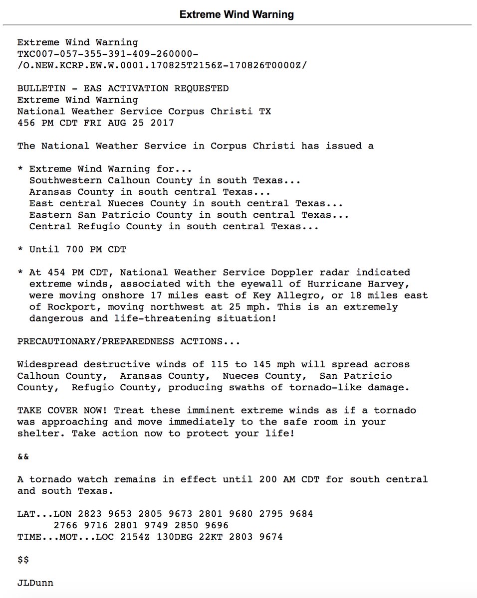
NWS extreme wind warning 115 to 145 mph.
Oh my. Per TWC.
Oh my. Per TWC.
edit on 25-8-2017 by DancedWithWolves because: (no reason given)
a reply to: roadgravel
They are on generator in CC and the fire department is not responding to calls till further notice.
www.intellicast.com...
They are on generator in CC and the fire department is not responding to calls till further notice.
www.intellicast.com...
This doesn't sound good. Make it closer to my place.
Hurricane Harvey Discussion Number 22
NWS National Hurricane Center Miami FL
400 PM CDT Fri Aug 25 2017
Harvey still has not slowed down, and the initial estimate is 325/9 kt.
Based on the forecast track, Harvey is expected to make landfall along the middle Texas coast tonight.
After that, the track models insist that the hurricane will slow down considerably
during the next 24 hours, and it is likely to move very little between 36 and 120 hours.
In fact, there has been a somewhat notable change in the guidance, with very few of the models showing
Harvey lifting out toward the northeast by the end of the 5-day forecast period. As a result, the NHC track forecast has been
pulled back a bit and keeps Harvey near or just inland of the Texas coast through the middle of next week.
www.wunderground.com...
edit on 8/25/2017 by roadgravel because: (no reason given)
new topics
-
S.C. Jack Smith's Final Report Says Trump Leads a Major Conspiratorial Criminal Organization!.
Political Conspiracies: 1 hours ago -
Advice for any young Adult .
General Chit Chat: 2 hours ago -
Joe meant what he said about Hunter's pardon....
US Political Madness: 3 hours ago -
Regent Street in #London has been evacuated due to a “bomb threat.”
Other Current Events: 4 hours ago -
It’s Falling…
Philosophy and Metaphysics: 5 hours ago -
Steering the Titantic from the Drydock.
Rant: 8 hours ago
top topics
-
Steering the Titantic from the Drydock.
Rant: 8 hours ago, 10 flags -
Joe meant what he said about Hunter's pardon....
US Political Madness: 3 hours ago, 9 flags -
Advice for any young Adult .
General Chit Chat: 2 hours ago, 6 flags -
S.C. Jack Smith's Final Report Says Trump Leads a Major Conspiratorial Criminal Organization!.
Political Conspiracies: 1 hours ago, 6 flags -
It’s Falling…
Philosophy and Metaphysics: 5 hours ago, 4 flags -
Regent Street in #London has been evacuated due to a “bomb threat.”
Other Current Events: 4 hours ago, 3 flags
active topics
-
Let's Buy Greenland
General Chit Chat • 20 • : CriticalStinker -
What Comes After January 20th
Mainstream News • 24 • : Dalamax -
S.C. Jack Smith's Final Report Says Trump Leads a Major Conspiratorial Criminal Organization!.
Political Conspiracies • 16 • : TzarChasm -
Los Angeles brush fires latest: 2 blazes threaten structures, prompt evacuations
Mainstream News • 29 • : Vermilion -
Labour Plotting to Postpone May's Council Elections ?
Regional Politics • 20 • : gortex -
Judge rules president-elect Donald Trump must be sentenced in 'hush money' trial
US Political Madness • 67 • : Xtrozero -
Steering the Titantic from the Drydock.
Rant • 38 • : ElitePlebeian2 -
Advice for any young Adult .
General Chit Chat • 6 • : nerbot -
Paramilitary Leaks - John Williams
Whistle Blowers and Leaked Documents • 10 • : Kaiju666 -
House Passes Laken Riley Act
Mainstream News • 19 • : marg6043