It looks like you're using an Ad Blocker.
Please white-list or disable AboveTopSecret.com in your ad-blocking tool.
Thank you.
Some features of ATS will be disabled while you continue to use an ad-blocker.
share:
Dear ATS Readers, Writers,
If this is posted in another place, forgive me, I thought this was the proper forum.
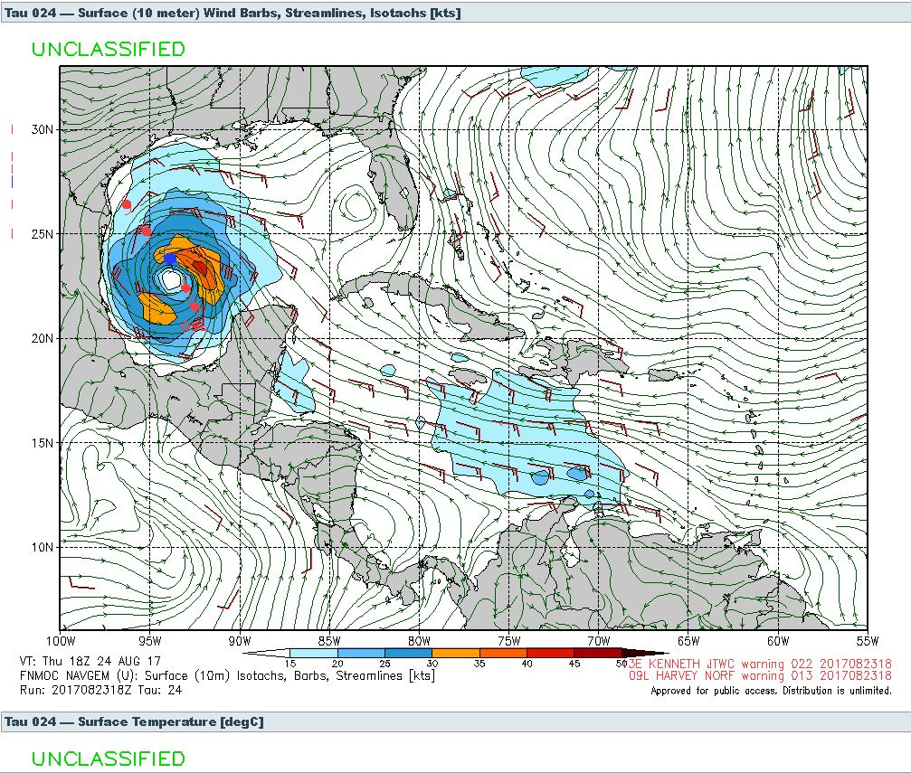
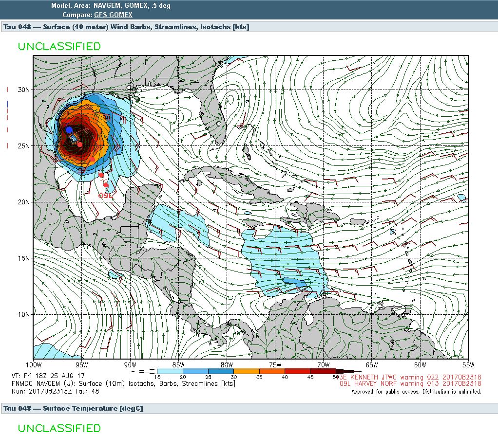
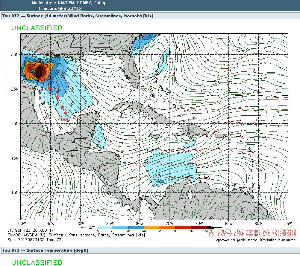
The tropical storm Harvey wil most likely strengthen greatly as it enters into Gulf waters..
Depending on it's forward speed, it could wind up into a huge hurricane before coming ashore.
If it is slow, the storm will build more powerful.
Catastrophic rain predicted for TX, LA, up to 43 inches
New Orleans is even apparently considering an evacuation due to the cities pumping system being in disrepair.
Personally, if it is slow enough, don't be surprised to see it reach Category 3 levels.
Pravdaseeker
If this is posted in another place, forgive me, I thought this was the proper forum.
The tropical storm Harvey wil most likely strengthen greatly as it enters into Gulf waters..
Depending on it's forward speed, it could wind up into a huge hurricane before coming ashore.
If it is slow, the storm will build more powerful.
Computer models tracking Tropical Storm Harvey entering the Gulf of Mexico are predicting an initial landfall in southern Texas, then re-entry to the Gulf of Mexico before a SECOND Landfall in southern Louisiana. Rainfall projections are being called “CATASTROPHIC” at forty-three inches (43″) [1100mm].
Making forecasts even worse: Risk also of a tornado outbreak if the trajectory and slow displacement of the storm is confirmed.
The European Model of weather forecasts has been incredibly reliable for storms such as this in the past, and according to various readings, Harvey (called Invest 09L) could develop into a Category 1 or 2 Hurricane within the next 24 hours!
Catastrophic rain predicted for TX, LA, up to 43 inches
New Orleans is even apparently considering an evacuation due to the cities pumping system being in disrepair.
Personally, if it is slow enough, don't be surprised to see it reach Category 3 levels.
Pravdaseeker
good luck to all those in the path. over here (uk) this year has seen more rain than any year i can remember. it's grim.
Good luck to everyone!
Stay safe!
edit on 23-8-2017 by Black_Fox because: (no reason given)
It seems "god" is tired of New Orleans.
I wish you all the best. Be safe.
I wish you all the best. Be safe.
AH, thanks for the weather video mate...
He fails to mention the extremely warm water temperature over the gulf region. Some areas in the high 80's... That is "quite warm".
Super spawning ground for rapidly hurricane strength storm.
I have a friend in the Houston area, and he is used to lots of rain, but 43 inches is even extreme for him.
Agreed, best of luck to those in it's path, don't be lackadaisical about this storm, watch it please.
I went through a category 2 cyclone in Oz, and that was "bad enough" for me. Don't care to experience 3 or higher...a 5 would be bomb shelter digging time..Ha!
Pravdaseeker
a reply to: Black_Fox
How could their pumps be down ?
It's New Orleans, of course it's going to flood.
Sheesh
It's New Orleans, of course it's going to flood.
Sheesh
(post by nowuknow removed for political trolling and baiting)
I live in central Louisiana and I gotta say this year has been a really wet one.
It's ok though, I'll take the rain instead of drought, thank god I live on a hill.
It's ok though, I'll take the rain instead of drought, thank god I live on a hill.
originally posted by: RoScoLaz5
good luck to all those in the path. over here (uk) this year has seen more rain than any year i can remember. it's grim.
Given what has happened to us in Kansas City this August (we've had 5"+ rainfall amounts on three separate occasions in what is traditionally one of the hottest and driest months of the year; Eclipse day with an 8" amount in our area was the icing on the cake), I can well believe this could develop. It would be worse than Katrina even if less destructive from a storm power perspective.
originally posted by: Cancerwarrior
I live in central Louisiana and I gotta say this year has been a really wet one.
It's ok though, I'll take the rain instead of drought, thank god I live on a hill.
Be careful. I wish you well.
a reply to: pravdaseeker
Forecasters in the DFW area are saying max Hurricane 1 with lingering in Tx. No mention of reentry to the gulf then La.
Tx only forecasts up to 20 inches here. (only..ha)
All forecasters have always said the European model is usually more correct but no mention this time.
Also we have had an unusual Aug with more rain and a little less heat. I heard a mention a few weeks ago that the El nino was not at strong as expected. Never even heard their was another El Nino this year.
Prayers for southern Tx and La. La has been hit hard of late with flooding and their pumps.
a reply to: pravdaseeker
Texas Gulf Coast between Houston and Galveston.
Been through many a storm throughout my nearly 50 years and have made the necessary prep to hunker down and ride it out. Never flooded here through all the prior storms going back to Camille, and so hope that continues.
Stay safe everyone, and if you haven't, check out North Atlantic Hurricane Watch 2017 for a lot of great suggestions and links related to hurricane and tropical storm preparation.
Will report in throughout.
edit on 23-8-2017 by jadedANDcynical because: (no reason given)
San Antonio here and we're expecting some of this action.
I may go streaking.
I may go streaking.
a reply to: jadedANDcynical
I'm in the same area neighbor. I see little need to worry about flooding here at home too. It will be the lack of power that has me worried. Time for all concerned to stock up on what you need to get by for a couple of days anyway.
Texas Gulf Coast between Houston and Galveston.
I'm in the same area neighbor. I see little need to worry about flooding here at home too. It will be the lack of power that has me worried. Time for all concerned to stock up on what you need to get by for a couple of days anyway.
a reply to: Arnie123
Just south of San Antonio here, we're going to alot of rain bud. San Antonio will probably flood. Like it did in 2010. Once it hits land, its going to bring alot of rain across the state. My house flooded in 2010. Fema came out and all that jazz.
My mom's in Houston. Worried about her.
Just south of San Antonio here, we're going to alot of rain bud. San Antonio will probably flood. Like it did in 2010. Once it hits land, its going to bring alot of rain across the state. My house flooded in 2010. Fema came out and all that jazz.
My mom's in Houston. Worried about her.
edit on 23-8-2017 by PlasticWizard because: (no reason given)
Thanks for the heads up, Ill have to message the father in law see if he is working near the gulf coast or not, 43 inches... that is a lot.
a reply to: pravdaseeker
This is setting up to be a major flood event, even if no one sees 40"(or even 20") and the storm does not become a hurricane.
I think a hurricane is likely and widespread flooding is certain.
Tomorrow's National Hurricane Center will have more input and hopefully that will give us a morw accurate forecast.
Fresh water flooding is the number 1 killer for hurricanes.
For the latest tropical weather information:
www.nhc.noaa.gov...
edit on 23-8-2017 by jrod because: D
Wow, thanks for the heads up. I am in DFW so probably all right but I don't have cable or anything and don't watch news so I had no clue this was
coming.
a reply to: myselfaswell
Currently only the Euro model takes the storm back out over the gulf and East into Louisiana.
Battle of New Orleans model war of 1812?

Currently only the Euro model takes the storm back out over the gulf and East into Louisiana.
Battle of New Orleans model war of 1812?

new topics
-
Inexplicable military simulation - virtual reality showdown in the night..
The Gray Area: 12 minutes ago -
The Truth about Migrant Crime in Britain.
Social Issues and Civil Unrest: 1 hours ago -
Trudeau Resigns! Breaking
Other Current Events: 3 hours ago -
Live updates: Congress meets to certify Trump's presidential election victory
US Political Madness: 4 hours ago -
Gravitic Propulsion--What IF the US and China Really Have it?
General Conspiracies: 4 hours ago -
Greatest thing you ever got, or bought?
General Chit Chat: 4 hours ago
top topics
-
Trudeau Resigns! Breaking
Other Current Events: 3 hours ago, 18 flags -
Live updates: Congress meets to certify Trump's presidential election victory
US Political Madness: 4 hours ago, 11 flags -
OK this is sad but very strange stuff
Paranormal Studies: 15 hours ago, 9 flags -
Islam And A Book Of Lies
Religion, Faith, And Theology: 16 hours ago, 6 flags -
Gravitic Propulsion--What IF the US and China Really Have it?
General Conspiracies: 4 hours ago, 6 flags -
The Truth about Migrant Crime in Britain.
Social Issues and Civil Unrest: 1 hours ago, 5 flags -
Greatest thing you ever got, or bought?
General Chit Chat: 4 hours ago, 3 flags -
Inexplicable military simulation - virtual reality showdown in the night..
The Gray Area: 12 minutes ago, 0 flags
active topics
-
Musk calls on King Charles III to dissolve Parliament over Oldham sex grooming gangs
Mainstream News • 192 • : Oldcarpy2 -
Live updates: Congress meets to certify Trump's presidential election victory
US Political Madness • 11 • : xuenchen -
Greatest thing you ever got, or bought?
General Chit Chat • 13 • : Shoshanna -
Inexplicable military simulation - virtual reality showdown in the night..
The Gray Area • 0 • : FlyInTheOintment -
-@TH3WH17ERABB17- -Q- ---TIME TO SHOW THE WORLD--- -Part- --44--
Dissecting Disinformation • 3951 • : angelchemuel -
Trudeau Resigns! Breaking
Other Current Events • 47 • : Flyingclaydisk -
The Truth about Migrant Crime in Britain.
Social Issues and Civil Unrest • 2 • : gortex -
Joe Biden gives the USA's Highest Civilian Honor Award to Hillary Clinton and George Soros.
US Political Madness • 55 • : hangedman13 -
OK this is sad but very strange stuff
Paranormal Studies • 6 • : StudioNada -
Gravitic Propulsion--What IF the US and China Really Have it?
General Conspiracies • 5 • : billxam1


