It looks like you're using an Ad Blocker.
Please white-list or disable AboveTopSecret.com in your ad-blocking tool.
Thank you.
Some features of ATS will be disabled while you continue to use an ad-blocker.
share:
Tsunami?? How long ago did it happen? CNN has it at 7.9 and 6 miles deep.
www.cnn.com...
Tsunami warnings (nothing so far). twitter.com...
www.cnn.com...
Tsunami warnings (nothing so far). twitter.com...
edit on 2-3-2016 by AlexanderM because: (no reason given)
edit on 2-3-2016 by AlexanderM because: (no reason
given)
edit on 2-3-2016 by AlexanderM because: (no reason given)
edit on 2-3-2016 by AlexanderM because: (no reason
given)
a reply to: AlexanderM
There have been a couple reported, and many more not reported, because simply the closest station is some 600 km away from the epicenter. Anything below a 4.0 at that distance is likely not to even be seen at all on seismometers.
Interestingly, this appears to be another intraplate quake, and not a subduction type megathrust quake. The first clue to this is the location, well out to sea beyond the subduction zone. Remember the big intraplate quakes of 2012 in this region?
earthquake.usgs.gov...
Because of the horizontal motion of the fault, little water was displaced, and hence why little or no tsunami was generated. Still scary nonetheless for people in Indonesia. And especially after what they went through in 2004.
There have been a couple reported, and many more not reported, because simply the closest station is some 600 km away from the epicenter. Anything below a 4.0 at that distance is likely not to even be seen at all on seismometers.
Interestingly, this appears to be another intraplate quake, and not a subduction type megathrust quake. The first clue to this is the location, well out to sea beyond the subduction zone. Remember the big intraplate quakes of 2012 in this region?
Large strike-slip earthquakes are not unprecedented in the diffuse boundary region separating the India and Australia plates, southwest of the Sumatra subduction zone. In 2012, two events of M 8.6 and M 8.2 on the same day (04/12/2012) ruptured a series of oceanic strike-slip structures 650-850 km to the north of the March 2, 2016 event. On June 18, 2000, a M 7.9 earthquake ruptured an oceanic strike-slip structure about 1000 km southeast of the March 2, 2016 earthquake. The focal mechanisms of the all of these earthquakes are consistent in implying that each event could have occurred as the result of left-lateral slip on an approximately north striking fault or right-lateral slip on an approximately west striking fault. The two different orientations of strike-slip faulting are both possible under the same tectonic stress field; perpendicular strike-slip faults that are both compatible with the same stress field are called "conjugate faults". In 2012, in-depth studies of those major events showed that faults of both orientations were involved in their rupture processes, breaking a network of conjugate faults over an area of ~ 200x200 km in size in the Wharton Basin. Because of the remote locations of these oceanic earthquakes, such events rarely cause shaking-related fatalities (the 2012 M 8.6 event caused two). Similarly, strike-slip earthquakes do not typically generate tsunamis.
earthquake.usgs.gov...
Because of the horizontal motion of the fault, little water was displaced, and hence why little or no tsunami was generated. Still scary nonetheless for people in Indonesia. And especially after what they went through in 2004.
originally posted by: muzzy
a reply to: Bishop2199
Also you can throw in "quiet periods", such as when there are NO further earthquakes AT ALL for several years inside that circle, ie. the crust is "locked". Anything that pops up eventually could be considered a "new" event. Sumatra might fit into this scenario, it has been a long time since there has been a M7 along the Aceh-Nias coast, enough time that I consider that Fault "locked" (and primed?).
I guess it's unlocked now.
Jeez, I guess we will be seeing more of this for a while.
earthquake.usgs.gov...
I haven't heard if there was alot of damage or injuries from the 7.9.
earthquake.usgs.gov...
I haven't heard if there was alot of damage or injuries from the 7.9.
Public ID 2016p167557
Intensity strong
Universal Time March 2 2016, 23:54:28
NZ Daylight Time Thu, Mar 3 2016, 12:54:28 pm
Depth 18 km
Magnitude 4.6
Location 25 km south-west of Whanganui
Latitude, Longitude -40.12, 174.86
Agency WEL(GNS_Primary)
1495 Felt Reports.
www.geonet.org.nz...
Lately these smaller "moderate" sized quakes seem to be causing a lot of shaking.
I didn't feel it as I was driving (again). From home the report was it was side to side, felt like a 5.+ would at the old house with wooden Piles.
That 4.3 in Christchurch last week had a Peak Ground Acceleration (horizontal) of 0.2, similar to what would have been felt in Wellington during the Cook Strait M6.5 and 6.6 Earthquakes of 2013
The PGA for the 22nd Feb earthquake that destroyed Christchurch was 0.76
edit on 03000000616116 by muzzy because: (no reason given)
Umm, those Idaho, Nevada earthquakes just keep on keeping on and so do I. 3.5M in Nevada. And when I look at the last seven days, both areas are
active. I probably ignore them as I have over the last few weeks except the ones in Idaho are showing two different trends. Tomato, Potato, whichever.
If it's tectonic then it may portend something bigger. If it's tectonic then we have a 30km span between the two epicenters. Is a fault that long? I
don't know.
All I know is they ain't stopping. Other swarms, like Reno for example, some and go over periods of years. These two areas don't stop, they only slow and don't go completely dormant.
All I know is they ain't stopping. Other swarms, like Reno for example, some and go over periods of years. These two areas don't stop, they only slow and don't go completely dormant.
edit on 3-3-2016 by ericblair4891 because: (no reason given)
a reply to: muzzy posted on Dec, 6 2015 @ 07:13 AM
SW of Kyushu just won't give up, still going!. Looks like it could go on for months yet.
As described in the original post there are 4 main areas, MainShock, Central, North and East.
The current earthquakes seem to be mostly in the North section.
Here's a screenshot of the entire series so far, 2456 events,
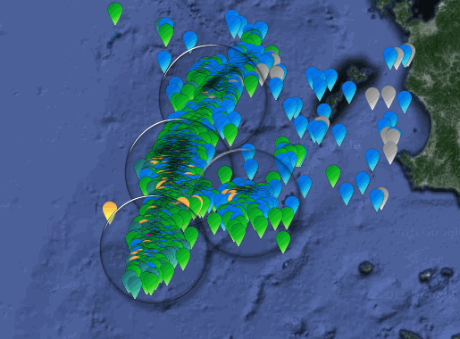
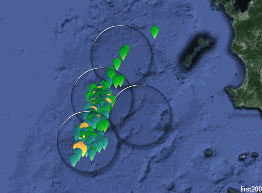
and one of the first 200 aftershocks, Gold Star is the 7.1 Main Shock
and one of the latest 200 aftershocks
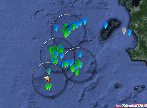
*I was trying to figure a way to post the numbered interactive Bing maps of the whole series on my Kyushu page, but it means making 24 individual maps of 200 events per map (thats the maximum allowed), and you can't actually load the interactive versions directly onto Blogger to look at, just put a link, so its probably a waste of time.
SW of Kyushu just won't give up, still going!. Looks like it could go on for months yet.
As described in the original post there are 4 main areas, MainShock, Central, North and East.
The current earthquakes seem to be mostly in the North section.
Here's a screenshot of the entire series so far, 2456 events,

and one of the first 200 aftershocks, Gold Star is the 7.1 Main Shock

and one of the latest 200 aftershocks

*I was trying to figure a way to post the numbered interactive Bing maps of the whole series on my Kyushu page, but it means making 24 individual maps of 200 events per map (thats the maximum allowed), and you can't actually load the interactive versions directly onto Blogger to look at, just put a link, so its probably a waste of time.
What's going on in the Red Sea???
4.8
182km SSW of Al Qunfidhah, Saudi Arabia
2016-03-07 22:43:24 UTC
10.0 km
4.4
107km NNE of Massawa, Eritrea
2016-03-06 04:38:19 UTC
10.0 km
4.5
156km SSW of Al Qunfidhah, Saudi Arabia
2016-03-06 00:05:02 UTC
10.0 km
4.2
148km SW of Al Qunfidhah, Saudi Arabia
2016-03-05 20:08:54 UTC
10.0 km
WOQ
4.8
182km SSW of Al Qunfidhah, Saudi Arabia
2016-03-07 22:43:24 UTC
10.0 km
4.4
107km NNE of Massawa, Eritrea
2016-03-06 04:38:19 UTC
10.0 km
4.5
156km SSW of Al Qunfidhah, Saudi Arabia
2016-03-06 00:05:02 UTC
10.0 km
4.2
148km SW of Al Qunfidhah, Saudi Arabia
2016-03-05 20:08:54 UTC
10.0 km
WOQ
edit on 7-3-2016 by wasobservingquietly because: (no reason given)
a reply to: wasobservingquietly
Spreading. African vs Arabian Plates
The immediate results can also be seen to the north as the African Plate subducts under the European Plate.
2016-03-07 14:25:15, 4.0, 35.32°N, 23.69°E, 10, Crete, Greece
2016-03-06 23:18:18, 4.2, 35.18°N, 23.63°E, 10, Crete, Greece
Spreading. African vs Arabian Plates
The immediate results can also be seen to the north as the African Plate subducts under the European Plate.
2016-03-07 14:25:15, 4.0, 35.32°N, 23.69°E, 10, Crete, Greece
2016-03-06 23:18:18, 4.2, 35.18°N, 23.63°E, 10, Crete, Greece
Looks like Pegasus Bay may have done it's dash, no quakes on the 5th march at all, and only a couple of 2's and 1's since.
Been 23 days now
mag1= 104
mag2= 193
mag3= 25
mag4= 3
mag5= 1
total= 326
TTNT= 6519.576
Pegasus Bay page
Geonets current forecast (Feb 22nd) is 12% chance of a M5 again in the next month, 59% in the next year. info.geonet.org.nz...
I will follow it through to the 15th March, to get the 30 days graph, unless something more happens after that
Another one I didn't feel!, geez these concrete slab foundations are great, I haven't felt a dozen quakes we have had since we moved here, but then
again I can't give my conceptional take on what they felt like can I.
Public ID 2016p188781
Intensity strong
Universal Time March 10 2016, 20:24:01
NZ Daylight Time Fri, Mar 11 2016, 9:24:01 am
Depth 11 km
Magnitude 4.6
Location 35 km east of Seddon
Latitude, Longitude -41.60, 174.45
www.geonet.org.nz...
again a smallish size quake for so many Felt Reports, 1266 at this stage, mostly Lower North Island, Wellington area
a reply to: Britguy
and a follow up to: muzzy
This made me look again;
F-E Region: Strait of Gibraltar
Time: 2016-03-09 23:46:08.1 UTC
Magnitude: 4.6 (Mw)
Epicenter: 3.65°W 35.66°N
Depth: 10 km
geofon.gfz-potsdam.de...
actually Alboran Sea South, but the FE region is Strait of Gibraltar
I had forgotten about the 5.1 and 5.2 and 5.1 in January, and missed the 5.1 in late Feb
quite the aftershock series for a moderate quake (the 5.2 being the "Mainshock"?)
rightclickviewimageforfullsizegraph
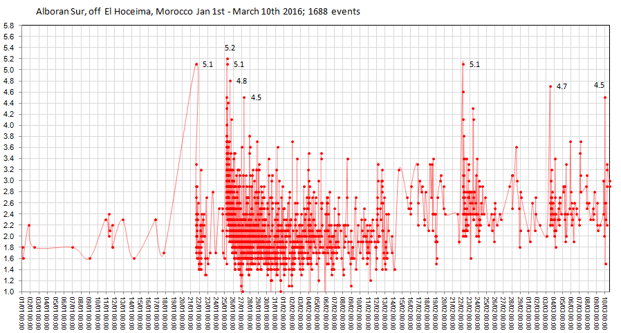
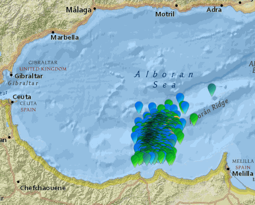
data from Instituto Geografico Nacional, Spain
KMZ file here
and a follow up to: muzzy
This made me look again;
F-E Region: Strait of Gibraltar
Time: 2016-03-09 23:46:08.1 UTC
Magnitude: 4.6 (Mw)
Epicenter: 3.65°W 35.66°N
Depth: 10 km
geofon.gfz-potsdam.de...
actually Alboran Sea South, but the FE region is Strait of Gibraltar
I had forgotten about the 5.1 and 5.2 and 5.1 in January, and missed the 5.1 in late Feb
quite the aftershock series for a moderate quake (the 5.2 being the "Mainshock"?)
rightclickviewimageforfullsizegraph


data from Instituto Geografico Nacional, Spain
KMZ file here
New seismic tracking idea I thought some might be interested in:
Global tracking using smart phone app from University of California Berkeley,
MyShake App
myshake.berkeley.edu...
earthquakes.berkeley.edu...
Global tracking using smart phone app from University of California Berkeley,
MyShake App
myshake.berkeley.edu...
earthquakes.berkeley.edu...
a reply to: muzzy
now a new twist to SW off Kyushu.
I just noticed on a weekly download quite a few events for W off Amakusa.
Nothing major, 168 of them the biggest is only 3.7
Turns out this is NE of where the North Section of aftershocks finishes, just a new JMA region name.
It is just over what I call the the Shimokoshiki Island skid mark, I have no idea what the feature is on Google Earth, some kind of trench.
Anyway, 168 extra events that could possibly be attributed to the Kyushu 7.1
Most of them in the last week.
I have marked them on the map below with a square glass.
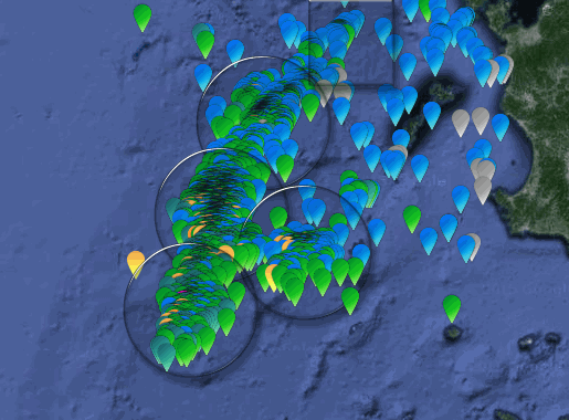
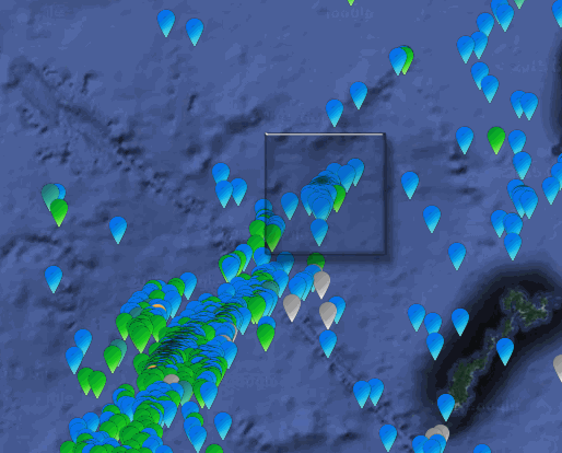
graph of same below
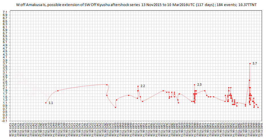
Getting closer to Nagasaki !
I have done a bunch of maps and graphs of the 4 main sections of this earthquake aftershock series
The graphs show how they are not only spaced by location, but also by time.
further down the page
*ATs loading very slow today, if at all, took half an hour and 3 attempts to even log on this afternoon. What gives?
now a new twist to SW off Kyushu.
I just noticed on a weekly download quite a few events for W off Amakusa.
Nothing major, 168 of them the biggest is only 3.7
Turns out this is NE of where the North Section of aftershocks finishes, just a new JMA region name.
It is just over what I call the the Shimokoshiki Island skid mark, I have no idea what the feature is on Google Earth, some kind of trench.
Anyway, 168 extra events that could possibly be attributed to the Kyushu 7.1
Most of them in the last week.
I have marked them on the map below with a square glass.


graph of same below

Getting closer to Nagasaki !
I have done a bunch of maps and graphs of the 4 main sections of this earthquake aftershock series
The graphs show how they are not only spaced by location, but also by time.
further down the page
*ATs loading very slow today, if at all, took half an hour and 3 attempts to even log on this afternoon. What gives?
a reply to: muzzy
More activity @ Alboran Sur
2016-03-12 15:17:12, 4.8, 35.66°N, 3.66°W, 10, C, Strait of Gibraltar
2016-03-12 15:04:06, 4.8, 35.64°N, 3.64°W, 10, C, Strait of Gibraltar
2016-03-11 04:16:48, 4.9, 35.63°N, 3.64°W, 10, C, Strait of Gibraltar
geofon.gfz-potsdam.de...
Instituto Geográfico Nacional (IGN) Spain
new topics
-
Azerbaijan E190 Passenger Jet Shot Down by Russia
Mainstream News: 30 minutes ago -
Orange County Makes Shoplifting a Felony
Other Current Events: 4 hours ago -
It's Offical Now
US Political Madness: 6 hours ago -
The reason it works is.....
General Chit Chat: 7 hours ago -
Dick Van Dyke saved from Wildfire by neighbours on his 99th birthday
People: 10 hours ago
top topics
-
Orange County Makes Shoplifting a Felony
Other Current Events: 4 hours ago, 13 flags -
It's Offical Now
US Political Madness: 6 hours ago, 11 flags -
The reason it works is.....
General Chit Chat: 7 hours ago, 7 flags -
Dick Van Dyke saved from Wildfire by neighbours on his 99th birthday
People: 10 hours ago, 5 flags -
Azerbaijan E190 Passenger Jet Shot Down by Russia
Mainstream News: 30 minutes ago, 4 flags
active topics
-
Azerbaijan E190 Passenger Jet Shot Down by Russia
Mainstream News • 5 • : Naftalin -
Orange County Makes Shoplifting a Felony
Other Current Events • 19 • : Coelacanth55 -
It's Offical Now
US Political Madness • 10 • : rickymouse -
The Acronym Game .. Pt.4
General Chit Chat • 1027 • : FullHeathen -
NYPD arrests migrant who allegedly set woman on fire on subway train, watched her burn to death
Breaking Alternative News • 54 • : Irishhaf -
Christmas Dinner ??
Food and Cooking • 18 • : network dude -
-@TH3WH17ERABB17- -Q- ---TIME TO SHOW THE WORLD--- -Part- --44--
Dissecting Disinformation • 3810 • : 777Vader -
Post A Funny (T&C Friendly) Pic Part IV: The LOL awakens!
General Chit Chat • 7953 • : underpass61 -
Dick Van Dyke saved from Wildfire by neighbours on his 99th birthday
People • 1 • : soulrevival -
The reason it works is.....
General Chit Chat • 3 • : BeyondKnowledge3
