It looks like you're using an Ad Blocker.
Please white-list or disable AboveTopSecret.com in your ad-blocking tool.
Thank you.
Some features of ATS will be disabled while you continue to use an ad-blocker.
share:
a reply to: crappiekat
I have 15 of them.
The links to 4 of them are at the bottom of every post from muzzy.
Are you taking the mickey?
I apologize for ranting on about the maps and such all the time, but it where I save the data in readable form to be able to base my observatios/opinions on.
I have a few new observations about the Marlborough 7.8 aftershocks that I seen on the map this morning, but I stuffed the page up trying to transfer the files that make up the maps out of the Dropbox Public folder to their own Folder.
I will come back later when I get it fixed.
Happy New Year to you too.
According to the time span allowed (3,5 hrs ) I might not make it back on this thread.
I have 15 of them.
The links to 4 of them are at the bottom of every post from muzzy.
Are you taking the mickey?
I apologize for ranting on about the maps and such all the time, but it where I save the data in readable form to be able to base my observatios/opinions on.
I have a few new observations about the Marlborough 7.8 aftershocks that I seen on the map this morning, but I stuffed the page up trying to transfer the files that make up the maps out of the Dropbox Public folder to their own Folder.
I will come back later when I get it fixed.
Happy New Year to you too.
edit on 1200000036536516 by muzzy because: (no reason given)
edit on 1200000036536516 by muzzy
because: (no reason given)
According to the time span allowed (3,5 hrs ) I might not make it back on this thread.
edit on 1200000036536516 by muzzy because: (no reason
given)
Final word on the Culverten-Cook Strait 7.8 aftershocks for 2016.
I have changed the name as the main quakes were not on the Hope Fault, although a lot of the smaller aftershocks were, and neither the Mainshock or the series are confined to Kaikoura, or the major uplift, so I don't know why Geonet refer to it as the Kaikoura 7.8 (probably because it is the nearest big town).
The last week I have noticed a few things out of the ordinary on the maps
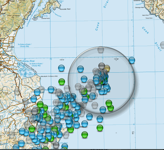
1. The Cook Strait 5.5 last week.
It just stopped there, all the aftershocksof the 5.5 were to the South. It is like there is a cross Fault that is stopping the series moving past towards the North Island.
This is good for now, but one wonders what kind of stress is being put on that Fault?

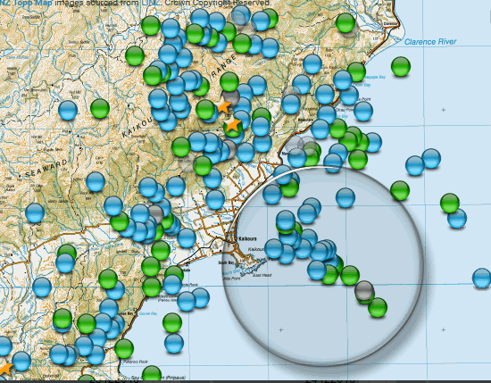
2. Kaikoura
There is a string of quakes coming out from just north of Kaikoura township in a SE direction out towards the Kaikoura Canyon. This is only in the last week. Another new "cross fault"?

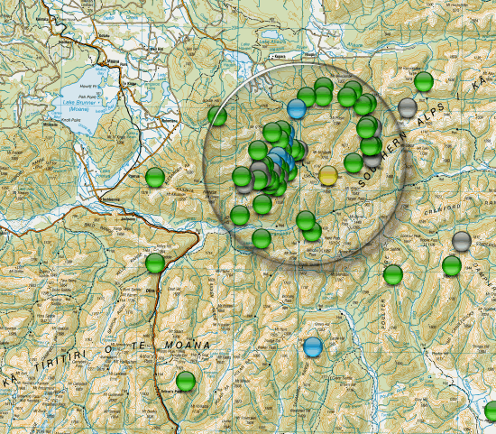
3. Inchbonnie
I have mentioned this area at the SW end of the Hope Fault before here, as a precurser to the big quake. It continues to pop out M2's right through the whole time period. Not sure what that circular pattern means. Is this another point of resistance? The main Alpine fault is only 10km to the West. Is the stress building here for the next "big one" on the Alpine Fault?

Culverden-CookStrait 7.8 aftershocks
Its all been redone and will survive the Dropbox dropout in Sept 2017, except for the trace graphs, I have to transfer those over yet.
I have changed the name as the main quakes were not on the Hope Fault, although a lot of the smaller aftershocks were, and neither the Mainshock or the series are confined to Kaikoura, or the major uplift, so I don't know why Geonet refer to it as the Kaikoura 7.8 (probably because it is the nearest big town).
The last week I have noticed a few things out of the ordinary on the maps
1. The Cook Strait 5.5 last week.
It just stopped there, all the aftershocksof the 5.5 were to the South. It is like there is a cross Fault that is stopping the series moving past towards the North Island.
This is good for now, but one wonders what kind of stress is being put on that Fault?

2. Kaikoura
There is a string of quakes coming out from just north of Kaikoura township in a SE direction out towards the Kaikoura Canyon. This is only in the last week. Another new "cross fault"?

3. Inchbonnie
I have mentioned this area at the SW end of the Hope Fault before here, as a precurser to the big quake. It continues to pop out M2's right through the whole time period. Not sure what that circular pattern means. Is this another point of resistance? The main Alpine fault is only 10km to the West. Is the stress building here for the next "big one" on the Alpine Fault?

edit on 1200000036536516 by muzzy because: (no reason given)
Culverden-CookStrait 7.8 aftershocks
Its all been redone and will survive the Dropbox dropout in Sept 2017, except for the trace graphs, I have to transfer those over yet.
edit on
1200000036536516 by muzzy because: (no reason given)
Got another little swarm going on in Brawley, Cali.
earthquake.usgs.gov...-info
The largest being a 3.9. So far today over a 106 events.
earthquake.usgs.gov...-info
The largest being a 3.9. So far today over a 106 events.
a reply to: crappiekat
Watched a documentary on the Salton Sea the other night, it's a dried up wasteland of pollution. Been drained over the years to provide Los Angeles with water. Some want to Nuke a trench through Brawley and let the Gulf of California flow in to the Salton.
Watched a documentary on the Salton Sea the other night, it's a dried up wasteland of pollution. Been drained over the years to provide Los Angeles with water. Some want to Nuke a trench through Brawley and let the Gulf of California flow in to the Salton.
edit on 1200000036536516 by
muzzy because: (no reason given)
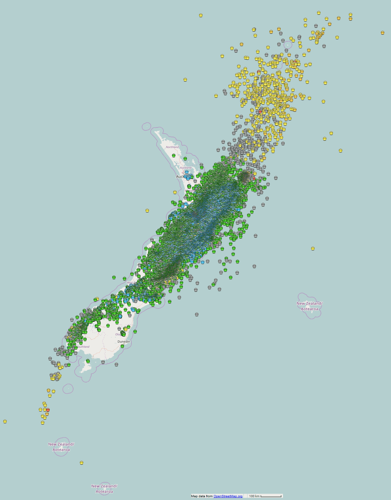
Results for NZ 2016
mag~1= 998
mag1= 10,099
mag2= 16,140
mag3= 4,303
mag4= 1,118
mag5= 133
mag6= 9
mag7= 2
total= 32,802
TTNT= 9,401,689
rightclickviewimagetoviewfullsize (1256x1680pixels)

Mag 5 interactive map
Went to edit the NZ6+ file, can't find it
I will have to reverse geocode the KMZ file to make a new Excel file with the new icon addresses.
mag~1= 998
mag1= 10,099
mag2= 16,140
mag3= 4,303
mag4= 1,118
mag5= 133
mag6= 9
mag7= 2
total= 32,802
TTNT= 9,401,689
rightclickviewimagetoviewfullsize (1256x1680pixels)

Mag 5 interactive map
Went to edit the NZ6+ file, can't find it
I will have to reverse geocode the KMZ file to make a new Excel file with the new icon addresses.
edit on 1200000036536516 by muzzy because:
(no reason given)
a reply to: muzzy
Well so it should have been drained as it was created by an error in the first place. (Well sort of)
Source: Wikipedia - Salton Sea
Well so it should have been drained as it was created by an error in the first place. (Well sort of)
The most recent inflow of water from the now heavily controlled Colorado River was accidentally created by the engineers of the California Development Company in 1905. In an effort to increase water flow into the area for farming, irrigation canals were dug from the Colorado River into the valley. Due to fears of silt buildup, a cut was made in the bank of the Colorado River to further increase the water flow. The resulting outflow overwhelmed the engineered canal, and the river flowed into the Salton Basin for two years, filling the historic dry lake bed and creating the modern sea, before repairs were completed.
Source: Wikipedia - Salton Sea
a reply to: PuterMan
The story was from the locals perspective they had built jettys and had got used to boating on the "sea" now the sea was gone the jettys were high and dry and the sediment left behind was toxic.
So the whole thing was a shambles from day one eh.
The story was from the locals perspective they had built jettys and had got used to boating on the "sea" now the sea was gone the jettys were high and dry and the sediment left behind was toxic.
So the whole thing was a shambles from day one eh.
a reply to: muzzy
I find the Salton Sea area very interesting. It's like a experiment that went wrong. But the question is, what will become of this place.
thinkprogress.org...
I have always thought that if the San Andrea's was gonna go off it will start with The San Jacinto fault. It just seem to have a lot of activity.

www.desertsun.com...
We just love to play with fire.
LOL!! I just got done watching the movie 2012. So I'm kinda in a Doom Porn mood.
I find the Salton Sea area very interesting. It's like a experiment that went wrong. But the question is, what will become of this place.
thinkprogress.org...
I have always thought that if the San Andrea's was gonna go off it will start with The San Jacinto fault. It just seem to have a lot of activity.

edit on 1-1-2017 by crappiekat because: to add link
www.desertsun.com...
We just love to play with fire.
edit on 1-1-2017 by crappiekat because: to add link
LOL!! I just got done watching the movie 2012. So I'm kinda in a Doom Porn mood.
edit on 1-1-2017 by crappiekat because: to add
I don't suppose anyone has noticed but the LISS plots in QVSData Pro have not been working for a while. I finally got round to finding out why. For
the moment you need to change the configuration details:

Click the image to enlarge
The top line has to be replaced with the bottom line. This is parameter ID 4050.
A fix will be included the next release.

Click the image to enlarge
The top line has to be replaced with the bottom line. This is parameter ID 4050.
A fix will be included the next release.
Just got the final numbers for 30+31Dec 2016 for Japan
so the totals are
mag~1= 128,221
mag1= 73,727
mag2= 26,686
mag3= 6,663
mag4= 1,180
mag5= 152
mag6= 21
mag7= 2
total= 236,652
total energy released= 5,205,897.472 TTNT
A lot more numbers compared to NZ, but the energy released is just over half
That 7.8 at Marlborough is the difference
I won't do a map, too dense to see anything
but here is a table of the Prefecture counts for 2016

so the totals are
mag~1= 128,221
mag1= 73,727
mag2= 26,686
mag3= 6,663
mag4= 1,180
mag5= 152
mag6= 21
mag7= 2
total= 236,652
total energy released= 5,205,897.472 TTNT
A lot more numbers compared to NZ, but the energy released is just over half
That 7.8 at Marlborough is the difference
edit on 010000001117 by muzzy because: (no reason given)
I won't do a map, too dense to see anything
but here is a table of the Prefecture counts for 2016

edit on 010000001117 by muzzy because: (no reason given)
I know it's 2017 and all, but I'm too shy to start a big ol' new thread in this ATS Land, so I'm adding on here:
Two big ones seem to have struck recently, towards the western side of the Pacifica Plate:
hisz.rsoe.hu...
and
hisz.rsoe.hu...
I know, I know, the folks here that I admire detest the RSOE map for various reasons. I can't seem to sever my attachment to the site, however. I did peruse the USGS site (which I am so much less familiar with), and that site seems to have these registered as different magnitudes altogether. I think. I can't tell. I don't speal the "USGS-ese" well enough yet to understand.
With this information. I'd like to add in that living in SoCal lately has made me feel like the one "Unpopped Kernel" in a bowl of popcorn. Just....tick...tick....tick...tick....
a reply to: HollywoodFarmGirl
There were a couple of big ones deep south of Fiji on the 2nd, also a 5.9.
So no one seems to want to start QW2017 eh?
I guess I will get it going later this morning, in the past I got it posted up before the start of the new year but thought I would hold back and give someone else a chance.
Ideally TrueAmerican would be a good host seeing he has all the contacts and the programs to get info before the Networks publish?
edit:
OK I have started 2017, go for your life
Quake Watch 2017 Link goes to /pg1
edit on 010000002217 by muzzy because: (no
reason given)
Resolute, Nunavut 5.8 (previously was saying 6.1)
emsc-csem.org
earthquake.usgs.gov...
2017-01-08 23:47:14.0 3hr 09min ago 74.36 N 92.29 W 33 5.8 DEVON ISLAND, NUNAVUT, CANADA
emsc-csem.org
M 5.8 - 86km ESE of Resolute, Canada V DYFI? VI ShakeMap GREEN PAGER Tsunami Warning Center Time 2017-01-08 23:47:12 (UTC) Location 74.320°N 92.305°W Depth 18.9 km
earthquake.usgs.gov...
5.4 strikes south edge of Cuba
www.ibtimes.com...
www.ibtimes.com...
A moderate earthquake rocked Cuba Tuesday morning, according to reports. The quake struck about 50 miles away from the southeast coast, with tremors felt about 100 miles away from the epicenter in cities including Santiago de Cuba, Guantanamo, Palma Soriano and Bayamo, Earthquake Track reported.
The earthquake hit at 4:08 a.m. local time nearly seven miles beneath the earth's surface. The United States Geological Survey (USGS) said the quake was 5.4-magnitude. However, the European-Mediterranean Seismological Center (EMSC) estimated a preliminary magnitude of 5.7.
There were no immediate reports of injuries of major damages caused by the quake. However, the its magnitude was felt by people near the epicenter and surrounding cities, many of whom reported on social media about experiencing aftershock tremors .
Still waking up, didn't notice this is 2016, but it was at the top?
7.9 west of Papua New Guinea.
www.cnn.com...
7.9 west of Papua New Guinea.
www.cnn.com...
edit on 22-1-2017 by AlexanderM because: (no reason
given)
edit on 22-1-2017 by AlexanderM because: (no reason given)
new topics
-
Angela Merkel is terrified of dogs
Politicians & People: 1 hours ago -
Will all hell break out? Jersey drones - blue beam
Aliens and UFOs: 7 hours ago -
Should be BANNED!
General Chit Chat: 9 hours ago
top topics
-
Signing back up
Introductions: 17 hours ago, 5 flags -
Should be BANNED!
General Chit Chat: 9 hours ago, 4 flags -
Will all hell break out? Jersey drones - blue beam
Aliens and UFOs: 7 hours ago, 3 flags -
Angela Merkel is terrified of dogs
Politicians & People: 1 hours ago, 1 flags
active topics
-
Will all hell break out? Jersey drones - blue beam
Aliens and UFOs • 17 • : CarlLaFong -
Drones over New Jersey
Aliens and UFOs • 33 • : LSU2018 -
Nathan Wade conspiring with Biden admin
US Political Madness • 14 • : WeMustCare -
Petition Calling for General Election at 564,016 and rising Fast
Political Issues • 153 • : gortex -
Fani Willis served subpoena by the U.S. Marshals Service
US Political Madness • 326 • : WeMustCare -
Fani Willis photo found on Thomas Matthew Crooks' cell phone
Politicians & People • 14 • : WeMustCare -
United Healthcare Shooting Suspect Nabbed in Pennsylvania
Mainstream News • 120 • : Thoughtful3 -
And Here Come the Excuses!!
General Conspiracies • 114 • : PorkChop96 -
President-Elect DONALD TRUMP's 2nd-Term Administration Takes Shape.
Political Ideology • 294 • : Oldcarpy2 -
Salvatore Pais confirms science in MH370 videos are real during live stream
General Conspiracies • 217 • : Lazy88

