It looks like you're using an Ad Blocker.
Please white-list or disable AboveTopSecret.com in your ad-blocking tool.
Thank you.
Some features of ATS will be disabled while you continue to use an ad-blocker.
share:
I have been away from home for 1.5 days without a computer, so got a bit behind on Chile.
Latest stuff I have just processed;
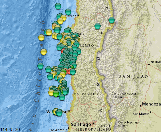
last 36 hrs map
graph showing the new stuff;
rightclickviewimageforfullsize
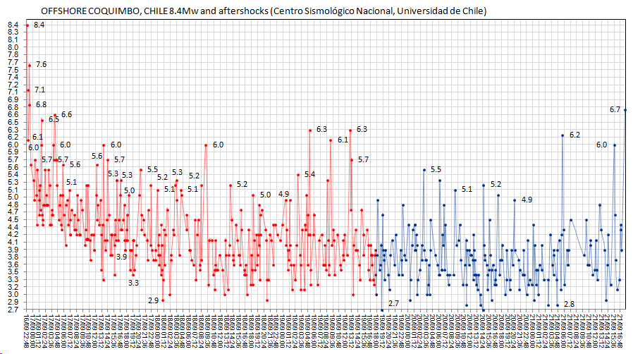
map showing all 541 events;
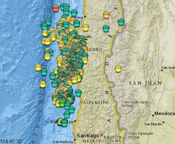
measurement of the main cluster of aftershocks shows a fault length of about 346km (215 mi.), but in the last 36 hrs it has extended a bit south towards the west of Valparaiso. I don't think those are background siesmicity, as there are 9 of them in 2 clusters 10.9 km (6.8 mi.) apart, and 60.1 km (37.3 mi.)south of the main aftershock cluster.
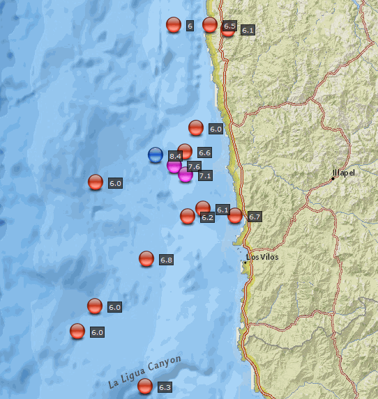
some more maps (while I had the GPS Vis. page open) titles left bottom corner
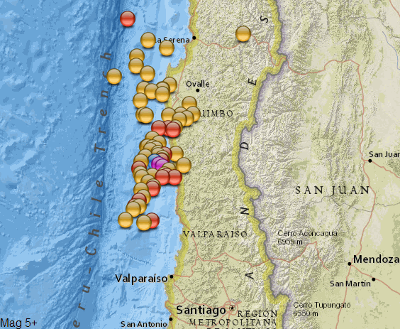
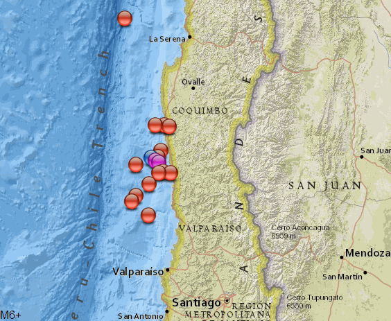
on the map above the most northern 6 is a 6.3
the rest are tagged below
Latest stuff I have just processed;
last 36 hrs map

graph showing the new stuff;
rightclickviewimageforfullsize

map showing all 541 events;

measurement of the main cluster of aftershocks shows a fault length of about 346km (215 mi.), but in the last 36 hrs it has extended a bit south towards the west of Valparaiso. I don't think those are background siesmicity, as there are 9 of them in 2 clusters 10.9 km (6.8 mi.) apart, and 60.1 km (37.3 mi.)south of the main aftershock cluster.
edit on 0900000026326315 by muzzy because: add more maps
some more maps (while I had the GPS Vis. page open) titles left bottom corner


on the map above the most northern 6 is a 6.3
the rest are tagged below

edit on 0900000026326315 by muzzy because: (no reason given)
a reply to: ericblair4891
I haven't really been following the rest of the US lately, just Bald Nountain, Nevada and a sideways glance at Oklahoma.
At first glance it does look quite active over 7 days timeline.
Because USGS have that big gap between 7 days and 30 days its hard to tell if thus is in fact an uptick, I'd have to look at ANSS and see what they have going back over that period.
I guess the Montana and Idaho quakes could be related to Yellowstone in some way, at 330km/200mi scale on the map that Bitteroot Range geographically looks part of the same section of the eastern Rockies as Yellowstone is. Whether that relates siesmically I'm not sure.
Nevada not so much, too far away I think.
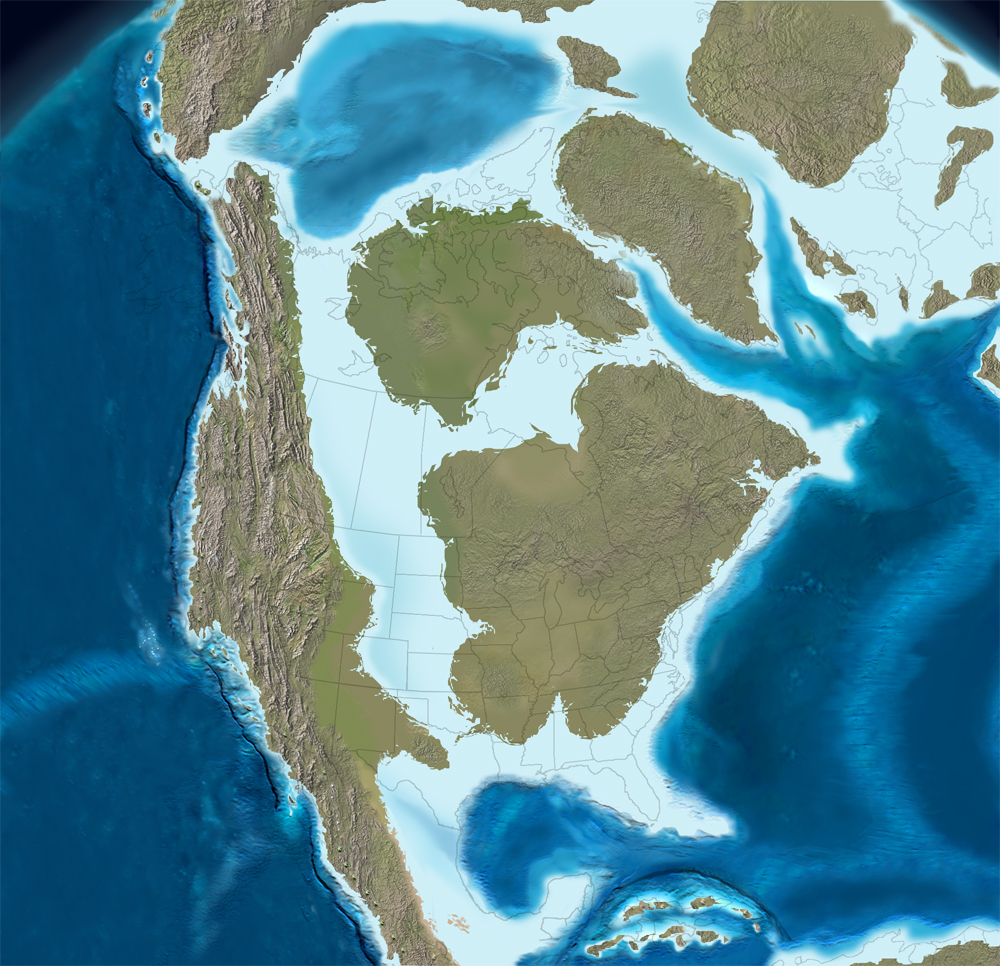
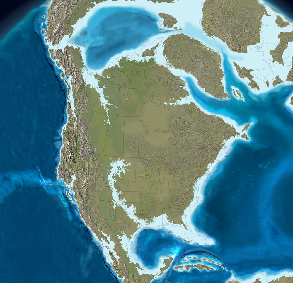
the answer may lie here Paleogeography and Geologic Evolution of North America, particularily in the
Late Cretaceous (75Mya)
rightclickviewimageforfullsize
and Cretaceous-Tertiary (65Mya)
rightclickviewimageforfullsize
is there a name for your area?
WY ID MT? WYomingIDahoMonTana
I haven't really been following the rest of the US lately, just Bald Nountain, Nevada and a sideways glance at Oklahoma.
At first glance it does look quite active over 7 days timeline.
Because USGS have that big gap between 7 days and 30 days its hard to tell if thus is in fact an uptick, I'd have to look at ANSS and see what they have going back over that period.
I guess the Montana and Idaho quakes could be related to Yellowstone in some way, at 330km/200mi scale on the map that Bitteroot Range geographically looks part of the same section of the eastern Rockies as Yellowstone is. Whether that relates siesmically I'm not sure.
Nevada not so much, too far away I think.
the answer may lie here Paleogeography and Geologic Evolution of North America, particularily in the
Late Cretaceous (75Mya)
rightclickviewimageforfullsize

and Cretaceous-Tertiary (65Mya)
rightclickviewimageforfullsize

is there a name for your area?
WY ID MT? WYomingIDahoMonTana
edit on 0900000026326315 by muzzy because: (no reason given)
edit on 0900000026326315 by muzzy because: (no reason
given)
further to post by: muzzy
Eric, this map is all the quakes ANSS have for the WYI'___' area for 265 days of 2015.
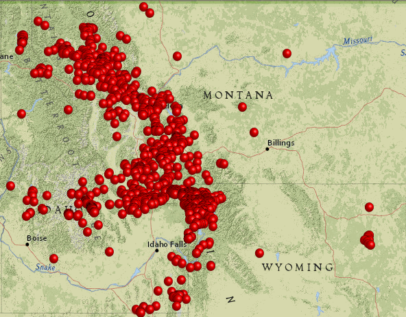
I have no doubt whatsoever that the activities in each state are related.
edit: what the heck is with the W Y I D M T coming out as WYI'___'
whats with '___' ?
is D M T code for something bad?
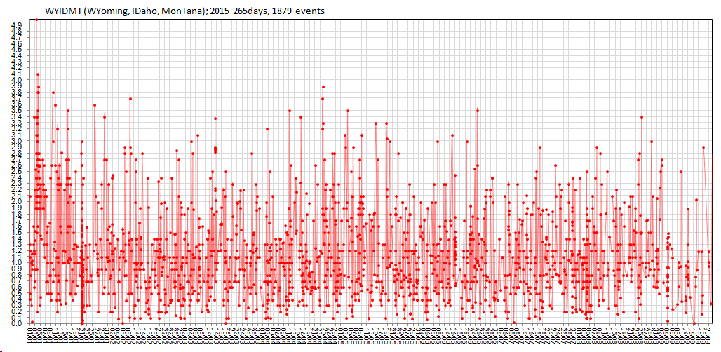
and of course a graph of that
rightclickviewimageforfullsize
Eric, this map is all the quakes ANSS have for the WYI'___' area for 265 days of 2015.

I have no doubt whatsoever that the activities in each state are related.
edit: what the heck is with the W Y I D M T coming out as WYI'___'
whats with '___' ?
is D M T code for something bad?
edit on 0900000026426415 by muzzy because: (no reason given)
and of course a graph of that
rightclickviewimageforfullsize

edit on 0900000026426415 by muzzy because: nothing much happening in either Japan or NZ
a reply to: muzzy
Naughty acronym
Seems the code is a bit simplistic.
Oh well.
We know what you meant.
P
Naughty acronym
Seems the code is a bit simplistic.
Oh well.
We know what you meant.
P
a reply to: pheonix358
isn't that a bit silly
what about dmt lower case?
edit:
seems OK
right, so it's wyidmt or WY-ID-MT then
isn't that a bit silly
what about dmt lower case?
edit:
seems OK
right, so it's wyidmt or WY-ID-MT then
edit on 0900000026426415 by muzzy because: (no reason given)
M4.2 - 201km W of Port Hardy, Canada
Time
2015-09-22 13:24:50 (UTC)
Nearby Cities
201km (125mi) W of Port Hardy, Canada
355km (221mi) W of Campbell River, Canada
380km (236mi) WNW of Courtenay, Canada
407km (253mi) WNW of Port Alberni, Canada
539km (335mi) WNW of Victoria, Canada
earthquake.usgs.gov...
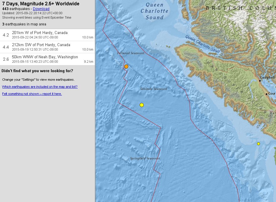
There was also a 4.4 the other day.
Time
2015-09-22 13:24:50 (UTC)
Nearby Cities
201km (125mi) W of Port Hardy, Canada
355km (221mi) W of Campbell River, Canada
380km (236mi) WNW of Courtenay, Canada
407km (253mi) WNW of Port Alberni, Canada
539km (335mi) WNW of Victoria, Canada
earthquake.usgs.gov...

There was also a 4.4 the other day.
Incoming! Local
Big Jolt, long gap, then wobbling
Universal Time September 23 2015, 18:47:53
NZ Standard Time Thu, Sep 24 2015, 6:47:53 am
Depth 152 km
Magnitude 5.3
Location 25 km south-east of Tokoroa
Latitude, Longitude -38.40, 176.06
www.geonet.org.nz...
wow thats a ways off from here, definitely a strong jolt, thought it was within 100km
deep
Big Jolt, long gap, then wobbling
edit on 0900000026526515 by muzzy because: (no reason given)
Universal Time September 23 2015, 18:47:53
NZ Standard Time Thu, Sep 24 2015, 6:47:53 am
Depth 152 km
Magnitude 5.3
Location 25 km south-east of Tokoroa
Latitude, Longitude -38.40, 176.06
www.geonet.org.nz...
wow thats a ways off from here, definitely a strong jolt, thought it was within 100km
deep
edit on 0900000026526515 by muzzy because: (no reason given)
originally posted by: muzzy
Incoming! Local
Big Jolt, long gap, then wobbling
Universal Time September 23 2015, 18:47:53
NZ Standard Time Thu, Sep 24 2015, 6:47:53 am
Depth 152 km
Magnitude 5.3
Location 25 km south-east of Tokoroa
Latitude, Longitude -38.40, 176.06
www.geonet.org.nz...
wow thats a ways off from here, definitely a strong jolt, thought it was within 100km
3.9?
Magnitude M 3.9
Region NORTH ISLAND OF NEW ZEALAND
Date time 2015-09-23 18:47:59.8 UTC
Location 38.45 S ; 176.23 E
Depth 100 km
Distances 339 km N of Wellington, New Zealand / pop: 381,900 / local time: 06:47:59.8 2015-09-24
86 km SW of Whakatane, New Zealand / pop: 18,602 / local time: 06:47:59.8 2015-09-24
29 km NE of Taupo, New Zealand / pop: 22,469 / local time: 06:47:59.8 2015-09-24
originally posted by: muzzy
Incoming! Local
Big Jolt, long gap, then wobbling
Universal Time September 23 2015, 18:47:53
NZ Standard Time Thu, Sep 24 2015, 6:47:53 am
Depth 152 km
Magnitude 5.3
Location 25 km south-east of Tokoroa
Latitude, Longitude -38.40, 176.06
www.geonet.org.nz...
wow thats a ways off from here, definitely a strong jolt, thought it was within 100km
That link seems to show a steady build of jolts and depth getting deeper all day today....is that odd? Starts at 3.2 and continually builds with each quake.
a reply to: Vasa Croe
Thats the estimating history of the location and magnitude by the automatic seismograph, not the sequence of quake happening itself
see how at the top it shows reviewed, thats it checked by a human
no way it was 3.9, we wouldn't have felt that
Definitely felt more towards where I live, and out east towards Napier
now called
25 km south-west of Rotorua, 167km deep, M5.1
Thats the estimating history of the location and magnitude by the automatic seismograph, not the sequence of quake happening itself
see how at the top it shows reviewed, thats it checked by a human
no way it was 3.9, we wouldn't have felt that
Definitely felt more towards where I live, and out east towards Napier
edit on 0900000026526515 by muzzy because: (no reason given)
now called
25 km south-west of Rotorua, 167km deep, M5.1
edit on 0900000026526515 by muzzy because: (no reason given)
USGS have 5.0mb
earthquake.usgs.gov...
I filled in the Felt Report form on USGS, they only gave me a Intensity of 3
Geonet gave me a 4 (light)
geez it made me jump though
according to USGS, was 357 away from me
earthquake.usgs.gov...
I filled in the Felt Report form on USGS, they only gave me a Intensity of 3
Geonet gave me a 4 (light)
geez it made me jump though
according to USGS, was 357 away from me
edit on 0900000026526515 by muzzy because: (no reason given)
a reply to: whatnext21
I recognise the style of the details you posted - EMSC
I see they have come to their senses.
www.emsc-csem.org...
3584 felt reports at this time
I recognise the style of the details you posted - EMSC
I see they have come to their senses.
Magnitude Mw 5.2
Region NORTH ISLAND OF NEW ZEALAND
Date time 2015-09-23 18:47:59.8 UTC
Location 38.45 S ; 176.23 E
Depth 100 km
Distances 339 km N of Wellington, New Zealand / pop: 381,900 / local time: 06:47:59.8 2015-09-24
86 km SW of Whakatane, New Zealand / pop: 18,602 / local time: 06:47:59.8 2015-09-24
29 km NE of Taupo, New Zealand / pop: 22,469 / local time: 06:47:59.8 2015-09-24
www.emsc-csem.org...
edit on 0900000026526515 by muzzy because: spelt they as tyhe, might have got away with it in the 16th century
3584 felt reports at this time
edit on 0900000026526515 by muzzy because: (no reason given)
Been just over a week now since Chile 8.4Mw
686 aftershocks to 24/09/2015 06:51:25 UTC
mag7= 2
mag6= 16
mag5= 55
mag4= 248
mag3= 346
mag2= 19
114:58:29 - 175:56:57 elapsed time map
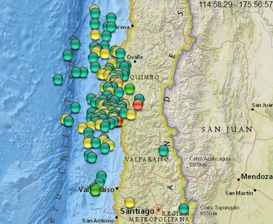
timeline graph
rightclickviewimageforfullsize
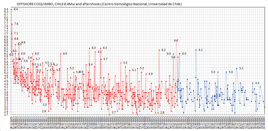
675 aftershocks to the 7 day mark
mag7= 2
mag6= 16
mag5= 55
mag4= 246
mag3= 338
mag2= 18
by comparison the Tohoku-Oki 2011 M9.0 earthquake produced 4271 aftershocks above M2 in 7 days;
mag7= 3
mag6= 48
mag5= 266
mag4= 658
mag3= 1159
mag2= 2137
the area I chose for this calculation was 40.9N, 33.14S, 137.27 and 144.9E, a little bit bigger than the official rupture zone, but not by much.
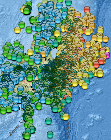
It might be fairer to compare to the 2010 Chile 8.8 though, I'll look into that.
686 aftershocks to 24/09/2015 06:51:25 UTC
mag7= 2
mag6= 16
mag5= 55
mag4= 248
mag3= 346
mag2= 19
114:58:29 - 175:56:57 elapsed time map

timeline graph
rightclickviewimageforfullsize

675 aftershocks to the 7 day mark
mag7= 2
mag6= 16
mag5= 55
mag4= 246
mag3= 338
mag2= 18
by comparison the Tohoku-Oki 2011 M9.0 earthquake produced 4271 aftershocks above M2 in 7 days;
mag7= 3
mag6= 48
mag5= 266
mag4= 658
mag3= 1159
mag2= 2137
the area I chose for this calculation was 40.9N, 33.14S, 137.27 and 144.9E, a little bit bigger than the official rupture zone, but not by much.

It might be fairer to compare to the 2010 Chile 8.8 though, I'll look into that.
M5.5 - 198km W of Port Hardy, Canada
50.733°N 130.235°W depth=10.0 km (6.2 mi)
Time
2015-09-24 13:48:58 (UTC)
2015-09-24 08:48:58 (UTC-05:00) in your timezone
Nearby Cities
198km (123mi) W of Port Hardy, Canada
363km (226mi) WNW of Campbell River, Canada
391km (243mi) WNW of Courtenay, Canada
398km (247mi) S of Prince Rupert, Canada
558km (347mi) WNW of Victoria, Canada
USGS
edit on 24-9-2015 by lurksoften because: down
graded by .1 and reviewed
a reply to: lurksoften
I was monitoring the PNW with GEE and caught these:
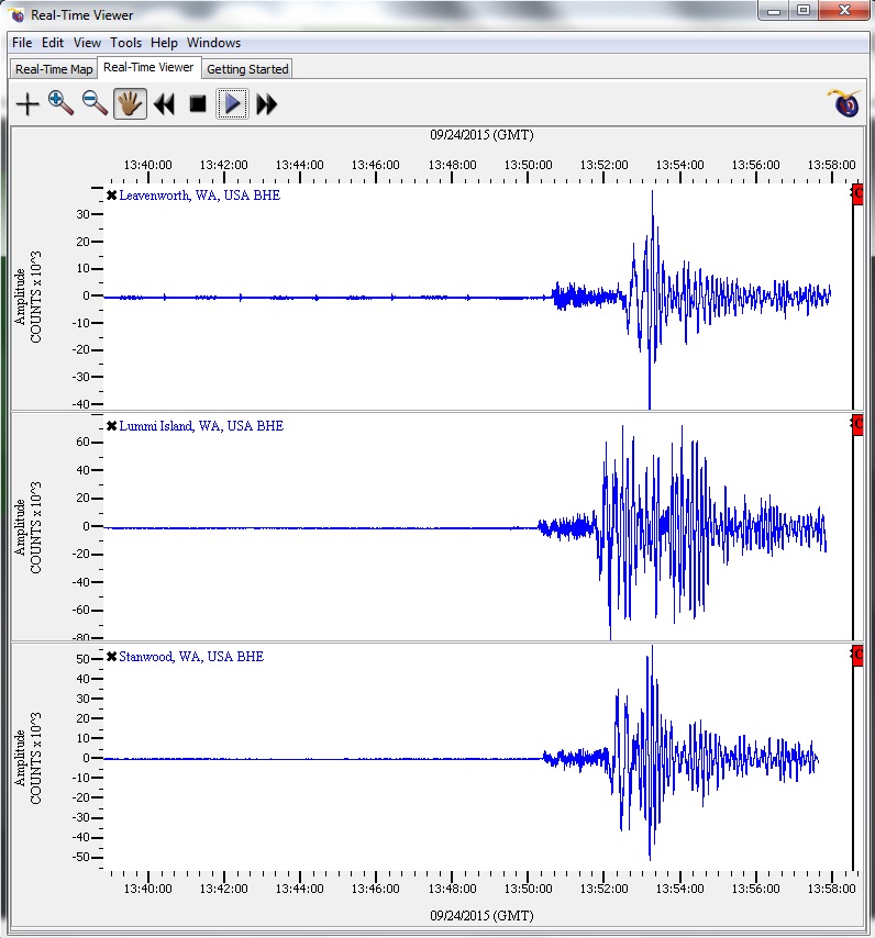
This looks to be that 5.6 that just occurred off the coast.
Stay Safe
Bishop
I was monitoring the PNW with GEE and caught these:

This looks to be that 5.6 that just occurred off the coast.
Stay Safe
Bishop
edit on 9/24/2015 by Bishop2199 because: I like change
I am seeing a large dip on the Leavenworth, WA monitor. I saw this earlier today for the same monitor a couple hours prior to the 5.5 nearby.
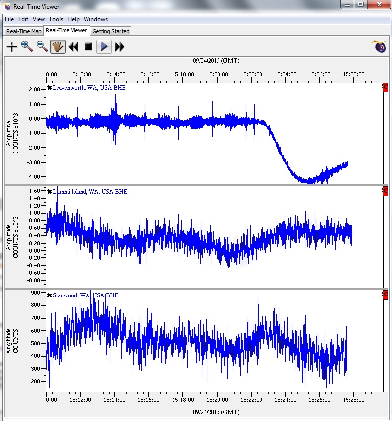
As a result, I am wondering if we will see another large one kickoff in the PNW in a couple of hours.
Stay Safe!
Bishop

As a result, I am wondering if we will see another large one kickoff in the PNW in a couple of hours.
Stay Safe!
Bishop
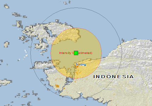
M6.6 - 28km N of Sorong, Indonesia
0.629°S 131.255°E depth=24.1 km (15.0 mi)
Time
2015-09-24 15:53:28 (UTC)
2015-09-24 10:53:28 (UTC-05:00) in your timezone
Nearby Cities
28km (17mi) N of Sorong, Indonesia
315km (196mi) W of Manokwari, Indonesia
396km (246mi) NE of Amahai, Indonesia
445km (277mi) SE of Tobelo, Indonesia
951km (591mi) SSW of Koror Town, Palau
USGS
EMSC 6.9Mw
Magnitude mb 6.0
Region SOLOMON ISLANDS
Date time 2015-09-24 15:56:57.1 UTC
Location 10.15 S ; 160.49 E
Depth 23 km
EMSC
a reply to: PuterMan
No problem glad to see you around.
edit on 24-9-2015 by lurksoften because: Sorong Quake Down Graded 6.9 to 6.6
edit on
24-9-2015 by lurksoften because: Emsc upgraded Sorong Quake 6.5 to 6.9
edit on 24-9-2015 by lurksoften because: Soloman quake
downgraded 6.4 to 6.0
2015-09-24 15:53:32, -0.614, 131.261, 6.9, 64.2
Irian Jaya Region. Ind. (196)
Sorry lurks - we were writing at the same time
Sorry lurks - we were writing at the same time
edit on 24/9/2015 by PuterMan because: (no reason given)
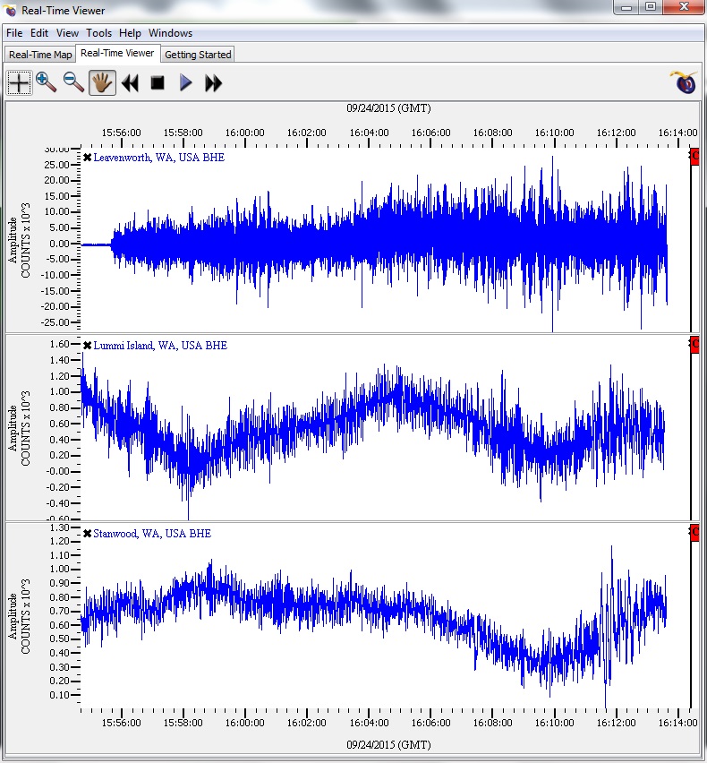
This is ongoing on the monitor in Leavenworth, WA. Whatever it is looks big, but it is not registering on the other two moniros.
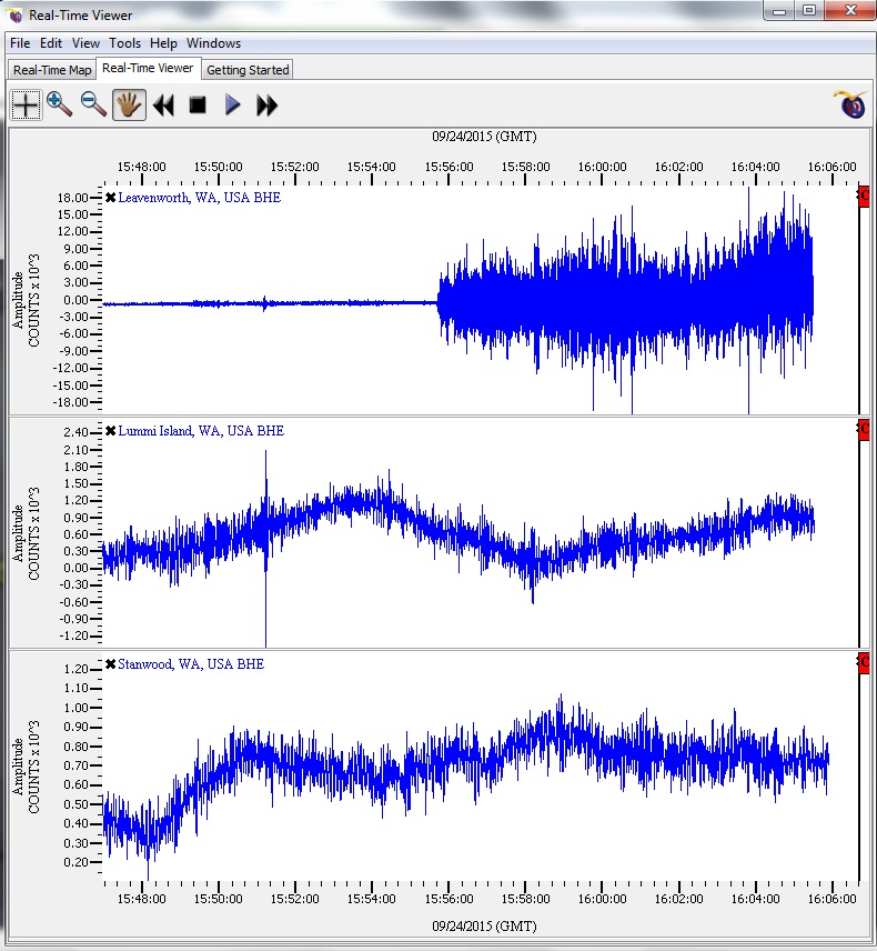
ETA: Could this be volcanic? That would maybe explain why this monitor would be registering an event while the island monitor and the distant land monitor would not. It continues to push the amplitude scale.
Stay Safe!
Bishop

ETA: Could this be volcanic? That would maybe explain why this monitor would be registering an event while the island monitor and the distant land monitor would not. It continues to push the amplitude scale.

Stay Safe!
Bishop
edit on 9/24/2015 by Bishop2199 because: I like change
new topics
-
Orange County Makes Shoplifting a Felony
Other Current Events: 3 hours ago -
It's Offical Now
US Political Madness: 5 hours ago -
The reason it works is.....
General Chit Chat: 6 hours ago -
Dick Van Dyke saved from Wildfire by neighbours on his 99th birthday
People: 8 hours ago
top topics
-
It's Offical Now
US Political Madness: 5 hours ago, 9 flags -
Orange County Makes Shoplifting a Felony
Other Current Events: 3 hours ago, 9 flags -
The reason it works is.....
General Chit Chat: 6 hours ago, 6 flags -
Dick Van Dyke saved from Wildfire by neighbours on his 99th birthday
People: 8 hours ago, 3 flags
active topics
-
The Acronym Game .. Pt.4
General Chit Chat • 1025 • : FullHeathen -
Christmas Dinner ??
Food and Cooking • 18 • : network dude -
Orange County Makes Shoplifting a Felony
Other Current Events • 13 • : mblahnikluver -
It's Offical Now
US Political Madness • 9 • : network dude -
-@TH3WH17ERABB17- -Q- ---TIME TO SHOW THE WORLD--- -Part- --44--
Dissecting Disinformation • 3810 • : 777Vader -
Post A Funny (T&C Friendly) Pic Part IV: The LOL awakens!
General Chit Chat • 7953 • : underpass61 -
Dick Van Dyke saved from Wildfire by neighbours on his 99th birthday
People • 1 • : soulrevival -
The reason it works is.....
General Chit Chat • 3 • : BeyondKnowledge3 -
London Christmas Market BANS Word ‘Christmas’
Social Issues and Civil Unrest • 44 • : Oldcarpy2 -
1 Billion dollars
General Entertainment • 12 • : Blueracer
