It looks like you're using an Ad Blocker.
Please white-list or disable AboveTopSecret.com in your ad-blocking tool.
Thank you.
Some features of ATS will be disabled while you continue to use an ad-blocker.
share:
geez I killed the thread, no posts for 36 hours!!??
meanwhile,
summary of plate thrusting going on down here;
133,760.25TTNT released in 40 hours and 20 seconds, south and north of New Zealand (13-14/10/2014)
and that is not counting 20.65TTNT from other events that we might call "background seismicity" across the rest of the country
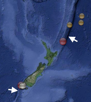
click image for interactive map centred on Solander-Puysegur 6.2 and aftershocks, zoom out for the whole 24 events
only 17 aftershocks from the 6.2, not many, usually those o/s Fiordland quakes have quite a few
could be all the energy hasn't been released yet
or could be the 6.2 is another aftershock of the Dusky Sound 2009 M7.8 ( a lot of the aftershocks of that were where this one was) . 5 years seems a long time for aftershocks to us, but in geological terms its just a few minutes.
meanwhile,
summary of plate thrusting going on down here;
133,760.25TTNT released in 40 hours and 20 seconds, south and north of New Zealand (13-14/10/2014)
and that is not counting 20.65TTNT from other events that we might call "background seismicity" across the rest of the country

click image for interactive map centred on Solander-Puysegur 6.2 and aftershocks, zoom out for the whole 24 events
only 17 aftershocks from the 6.2, not many, usually those o/s Fiordland quakes have quite a few
could be all the energy hasn't been released yet
or could be the 6.2 is another aftershock of the Dusky Sound 2009 M7.8 ( a lot of the aftershocks of that were where this one was) . 5 years seems a long time for aftershocks to us, but in geological terms its just a few minutes.
edit on 1000000028728714 by muzzy because: (no reason given)
a reply to: GoShredAK
As has been explained here before these apps often pick up on listing from two different networks that both feed into the USGS data. Usually this is either PT or the AT network which is then replaced by the US network version but often for large quakes both versions exist side by side for a while and very occasionally as long as a day.
You only have to find a seismo station nearby to determine what is happening, or just realise that if one entry is say PT and the other US then they are 99% likely to be the same quake.
Bit of a ruckass going on Iran/Iraq Border Region again
M5.6-5.8, depending on who you look at
International Institute of Earthquake Engineering and Seismology, Iran puts it 9.19km SE of the M6.0 of18/08/2014 02:32:06, most of the aftershocks since the 5.6 have been around Karkheh Dam Lake
I didn't really follow the 18/08/2014 East of Dehloran M6.0 aftershocks beyond 46 hours, maybe it has been going on continuously since then?
here is an interactive map of the Aug 46hrs and the lastest 5.6 with aftershocks combined together, with a bit of fiddling around with the menu on the left you can view one or the other or both (tick or untick the boxes)
Seems overall the earthquake activity has moved SE.
I'll look into their database Aug through Now and see whats been happening.
timeline graph is the best way to see
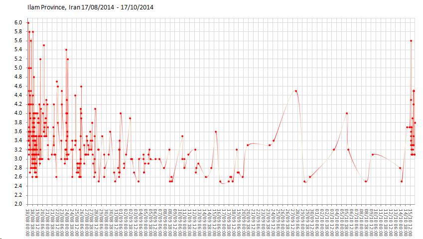
I suppose because of the close distance, it could be considered an aftershock, but based on time and activity between ( lack of),
hmmm not so sure, and its in a new direction (see map and instructions)
might be a stand alone new quake
Interactive Map above has been updated to show the interim quakes.
further to the instructions above;
heck, this is what you can do, as described.
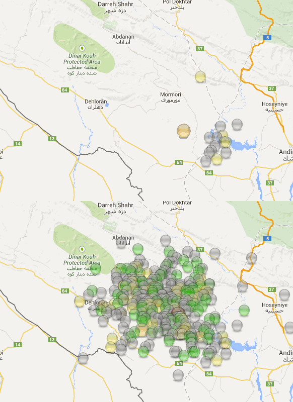
Sorry didn't get the scale in, the lake is about 30km long at that scale.
M5.6-5.8, depending on who you look at
International Institute of Earthquake Engineering and Seismology, Iran puts it 9.19km SE of the M6.0 of18/08/2014 02:32:06, most of the aftershocks since the 5.6 have been around Karkheh Dam Lake
I didn't really follow the 18/08/2014 East of Dehloran M6.0 aftershocks beyond 46 hours, maybe it has been going on continuously since then?
here is an interactive map of the Aug 46hrs and the lastest 5.6 with aftershocks combined together, with a bit of fiddling around with the menu on the left you can view one or the other or both (tick or untick the boxes)
Seems overall the earthquake activity has moved SE.
I'll look into their database Aug through Now and see whats been happening.
edit on 1000000028828814 by muzzy because: (no reason
given)
timeline graph is the best way to see

I suppose because of the close distance, it could be considered an aftershock, but based on time and activity between ( lack of),
hmmm not so sure, and its in a new direction (see map and instructions)
might be a stand alone new quake
Interactive Map above has been updated to show the interim quakes.
edit on 1000000028828814 by muzzy because: (no reason given)
edit on 1000000028828814 by muzzy because: missing a
]
edit on 10u28828814 by muzzy because: (no reason given)
further to the instructions above;
heck, this is what you can do, as described.

Sorry didn't get the scale in, the lake is about 30km long at that scale.
edit on 1000000028828814 by muzzy because: (no reason given)
This made a few people jump, pretty rare there
www.geonet.org.nz...
old style felt reports, which I prefer
In fact its the biggest quake in 10 years within 150km of Dunedin
interactive map earthquake history M4+ for 150km radius of Dunedin 1840-2014.
earliest and biggest quakes 1876, 3 x M5.8's at the same spot, just up the coast at Kakanui
1876-02-25 15:50
1876-02-25 21:15
1876-04-11 00:10
ID: 2014p779024 Network: geonet
Status: confirmed
Date/Time NZDT: 16/10/2014 18:44:04
Date/Time UTC: 16/10/2014 05:44:04
Latitude, Longitude: -45.7673, 170.1461
Magnitude: 4.07M
Depth: 3.90 km
Energy Released: 18.9412 tonnes of TNT
30km West of Dunedin, Otago
www.geonet.org.nz...
old style felt reports, which I prefer
edit on 1000000028828814 by muzzy because: (no reason given)
In fact its the biggest quake in 10 years within 150km of Dunedin
interactive map earthquake history M4+ for 150km radius of Dunedin 1840-2014.
earliest and biggest quakes 1876, 3 x M5.8's at the same spot, just up the coast at Kakanui
1876-02-25 15:50
1876-02-25 21:15
1876-04-11 00:10
edit on 10u28828814 by muzzy because: (no reason given)
Guys.....found this insane report of a mag 12....seriously?!...in West Africa 4 hours ago. Must be, got to be...a mistake. Can't get into USGS just
now at all. What you think?
Glodal incident map
Glodal incident map
a reply to: caitlinfae
Here is a screenshot:
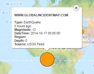
I don't know what to make of it. It says at a depth of 0 which means something occurred at the surface.
ETA: This looks like a site which compiles data from other more reputable sites. USGS is not indicating that anything has occurred recently in West Africa, at least not seismically.
So long . . . and thanks for all the fish!
Bishop
Here is a screenshot:

I don't know what to make of it. It says at a depth of 0 which means something occurred at the surface.
ETA: This looks like a site which compiles data from other more reputable sites. USGS is not indicating that anything has occurred recently in West Africa, at least not seismically.
So long . . . and thanks for all the fish!
Bishop
edit on 10/17/2014 by Bishop2199 because: I like change.
For the Egyptian readers (are there any here?)
I haven't got any reading EQ Archives, yet.
A few from Isreal and Lebanaon and Saudi looking in, the Egyptian National Seismograph Network (ENSN) covers their areas too.
Egypt 2014 in Arabic.
Egypt 2014 (in English) .... all new ..... I dropped the ball on their area this year, so a big update now.
Ha, on translation the maps are right to left too
edit on 1000000028928914 by muzzy because: (no reason given)
a reply to: caitlinfae
The magnitude of 12 should tell you immediately that this was not real. A magni5tude 12 quake just is physically not possible. About the largest possible is a Mag 10.5
The magnitude of 12 should tell you immediately that this was not real. A magni5tude 12 quake just is physically not possible. About the largest possible is a Mag 10.5
a reply to: Bishop2199
I have been doing a bit more digging. The event was posted, but the USGS posted it as a Mag 4.9 at Latitude 0, Longitude 0 and with a date that was December 31st 2,999, and at depth 0.
In other words most parameters were at their default settings. I have just deleted the event but the data WAS published so Global Incident are not incorrect as they did receive the data. Quite why it got changed from 4.9 to Mag 12 I don't know.
Umm, U.S. tax dollars hard at work?
It's a very basic tutorial on seismometers and webicorders.
It's a very basic tutorial on seismometers and webicorders.
18 events @ Emerald Fracture Zone, Balleny Islands Region, (Pacific-Antarctic Ridge)
Lamont-Doherty Earth Observatory (LDEO)
all depths default 33km
www.ldeo.columbia.edu...
interactive map
*note: duplications on lat/long
accuracy of location is not LDEO's strong point
but they do catch a lot of events the other networks miss down in this area
confirmed by LISS QSPA (South Pole Remote Earth Science Observatory (Quiet Zone))
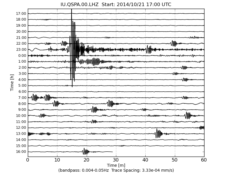
link
and SNZO
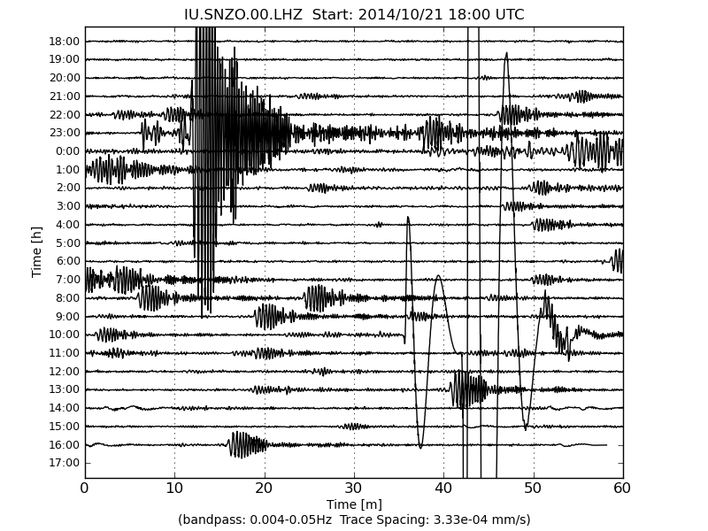
link
and another
22/10/2014, 13:30:08, 5.1, -63.25, 170.25
(not shown on map or list, as it happened after I created it)
and looks like another one 15:23ish and at 16:10ish not listed yet (based on LISS graphs)
I have to say LISS is one of Useless's better products, even if the graphs are more fuzzy than they used to be.
and another at 17:07ish (graph again)
I'll leave you with it have to go to work
Lamont-Doherty Earth Observatory (LDEO)
all depths default 33km
WHEN, TIME, MAG, LAT, LONG
20/10/2014, 07:58:56, 5.8, -61.75, 161.25
21/10/2014, 21:52:32, 4.8, -63, 171
21/10/2014, 21:58:08, 5.1, -63, 171
21/10/2014, 22:35:28, 5.1, -63, 171
21/10/2014, 23:01:20, 5.6, -63.5, 169.5
21/10/2014, 23:26:56, 5.2, -63, 171
22/10/2014, 02:14:08, 4.9, -63.25, 170.75
22/10/2014, 04:39:12, 4.9, -63, 171
22/10/2014, 04:58:32, 4.8, -63.5, 170.5
22/10/2014, 06:48:00, 5.1, -63.25, 170.75
22/10/2014, 06:52:32, 5.1, -63.25, 170.75
22/10/2014, 07:39:12, 4.9, -63, 171
22/10/2014, 07:55:20, 5.1, -63, 171
22/10/2014, 08:13:52, 5.1, -63.25, 170.25
22/10/2014, 09:08:24, 5.1, -63.25, 170.75
22/10/2014, 10:40:08, 5.1, -63.25, 170.25
22/10/2014, 11:08:16, 4.9, -62.75, 171.25
22/10/2014, 11:36:08, 4.8, -63.25, 170.25
www.ldeo.columbia.edu...
interactive map
*note: duplications on lat/long
accuracy of location is not LDEO's strong point
but they do catch a lot of events the other networks miss down in this area
confirmed by LISS QSPA (South Pole Remote Earth Science Observatory (Quiet Zone))

link
and SNZO

link
edit on 1000000029429414 by
muzzy because: (no reason given)
and another
22/10/2014, 13:30:08, 5.1, -63.25, 170.25
(not shown on map or list, as it happened after I created it)
and looks like another one 15:23ish and at 16:10ish not listed yet (based on LISS graphs)
I have to say LISS is one of Useless's better products, even if the graphs are more fuzzy than they used to be.
edit on 10u29429414 by muzzy because: trouble with the tags
and another at 17:07ish (graph again)
I'll leave you with it have to go to work
edit on 10u29429414 by muzzy because: (no reason given)
a reply to: AlexanderM
No I don't think they are aftershocks, but the 5.8 remains the biggest so far
the rest of them started 38 hrs later, but note they are 520km to the west
the 5.8 was actually on a Triple Junction Oceanic Spreading Rift/ OceanicTransform Fault and Oceanic Convergent Boundry ,
the others on a Transform Fault two zag's away ( as in zig-zag pattern of Transform Faults)
could be the 5.8 triggered a weak point on the other Fault and it has let loose with its own Swarm ( with a 5.6 in it)
I forgot to include the Plate Boundries file in the KMZ, have fixed that. If you look at the map now and then tick or untick the relevant boxes in the left hand side menu you will see what I mean. Switch to Satellite to see the Fracture Zones.
updated map
looks like there were 2 more after the last one I posted, and nothing since (LDEO posted) for 9 hours, could be a couple of mid 4's is all.
I was a bit out with the S wave travel times on the graph, geez over 9 minutes to SNZO! and 10 minutes 35 seconds to QSPA (South Pole)
edit:
I might restart my LISS archive page again, the "new" graphs are inferior to the older ones, but its better than nothing at all. IRIS graphs just don't cut it for a Global Overview.
2011-2013 LISS graph archive
edit on 10u29529514 by muzzy because: (no reason
given)
Alaska just had a good one:
Magnitude: 5.2 Ml Not Specified
Location: 65.198°N, 149.026°W ± 0.0 km
Depth: 10.0 km ± 0.0 km
Number of Stations Used: 27
Number of Phases Used: 27
Minimum Distance: 65.8 km (0.59°)
Travel Time Residual: 1.06 sec
Azimuthal Gap: 58°
Review Status: MANUAL
Event ID: at00ndwoio
ETA: and an aftershock . . .
Location: 65.169°N, 149.054°W Not Specified
Depth: 14.9 km ± 10.6 km
Number of Stations Used: Not Specified
Number of Phases Used: 62
Minimum Distance: 45.2 km (0.41°)
Travel Time Residual: 1.12 sec
Azimuthal Gap: 111°
Review Status: MANUAL
Event ID: usb000sq4c
So long . . . and thanks for all the fish!
Bishop
edit on 10/23/2014 by Bishop2199 because: (no reason given)
further to post by: muzzy about Balleny Islands series
updated interactive map
graph of the series, so far (LDEO data)
M5.8, then
23 events in 24 hours
plus 2 more
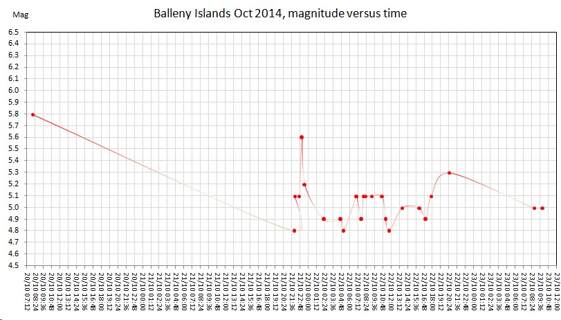 rightclick"viewimage"forfullsize
extended QSPA LISS graph (LDEO didn't get them all) (and didn't get the 5.8)
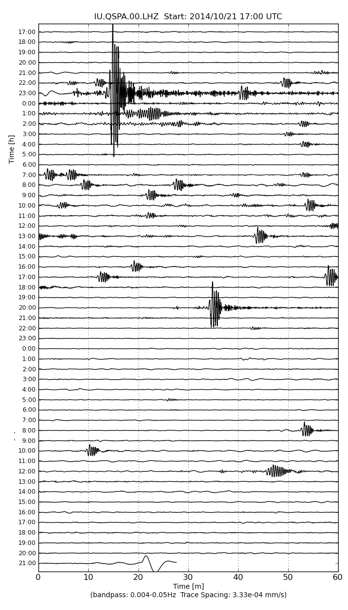 rightclick"viewimage"forfullsize
updated interactive map
graph of the series, so far (LDEO data)
M5.8, then
23 events in 24 hours
plus 2 more

extended QSPA LISS graph (LDEO didn't get them all) (and didn't get the 5.8)

edit on 10u29529514 by muzzy because: (no reason given)
missed one earlier in the week
map
ID: 2014p788527 Network: geonet
Status: confirmed
Date/Time NZDT: 20/10/2014 07:07:42
Date/Time UTC: 19/10/2014 18:07:42
Latitude, Longitude: -45.1849, 167.4584
Magnitude: 5.12M
Depth: 133.67 km
Energy Released: 720.2916 tonnes of TNT
Pt. 1417M, South West Arm, Lake Ta Anau
map
M 4.7 - 257km NE of Santa Cruz das Flores, Portugal
Time
2014-10-25 20:19:05 UTC-05:00
Location
41.310°N 29.306°W
Depth
10.0km
earthquake.usgs.gov...
Time
2014-10-25 20:19:05 UTC-05:00
Location
41.310°N 29.306°W
Depth
10.0km
earthquake.usgs.gov...
15,618 earthquakes added to Earthquake Archives
namely Iceland 2007 earthquakes recorded by IMO
This was the year of the Upptyppingar Swarm Feb through Dec, 5,300 events in that!
Animation and map images of that (for those that don't bother reading ATS Volcano Watch) here
namely Iceland 2007 earthquakes recorded by IMO
This was the year of the Upptyppingar Swarm Feb through Dec, 5,300 events in that!
Animation and map images of that (for those that don't bother reading ATS Volcano Watch) here
new topics
-
Federal law trumps state and local law every time
Social Issues and Civil Unrest: 2 hours ago
top topics
-
DOJ Special Counsel Robert HUR Says JOE BIDEN Can Be ARRESTED After Jan 20th 2025.
Above Politics: 15 hours ago, 12 flags -
Federal law trumps state and local law every time
Social Issues and Civil Unrest: 2 hours ago, 6 flags
active topics
-
Federal law trumps state and local law every time
Social Issues and Civil Unrest • 4 • : Bluntone22 -
Ed Dowd some good news
Medical Issues & Conspiracies • 37 • : Owlwatcher -
I thought Trump was the existential threat?
World War Three • 69 • : underpass61 -
Well, here we go red lines crossed Biden gives the go ahead to use long range missiles
World War Three • 373 • : bastion -
DOJ Special Counsel Robert HUR Says JOE BIDEN Can Be ARRESTED After Jan 20th 2025.
Above Politics • 19 • : matafuchs -
Petition Calling for General Election at 564,016 and rising Fast
Political Issues • 90 • : gortex -
Post A Funny (T&C Friendly) Pic Part IV: The LOL awakens!
General Chit Chat • 7828 • : baddmove -
Russia Ukraine Update Thread - part 3
World War Three • 6889 • : Oldcarpy2 -
The Acronym Game .. Pt.4
General Chit Chat • 990 • : KnowItAllKnowNothin -
Anyone like the Scorpions?
Music • 17 • : KrustyKrab
