It looks like you're using an Ad Blocker.
Please white-list or disable AboveTopSecret.com in your ad-blocking tool.
Thank you.
Some features of ATS will be disabled while you continue to use an ad-blocker.
share:
Don't really know if this is significant or not, but here is a 5 mag right on the junction on the Indian ridge.
earthquake.usgs.gov...
earthquake.usgs.gov...
reply to post by MamaJ
Not all that often.
300 Mile radius of that one from 2009 onwards
100 in the ANSS database back to 1965 and just one in the centennial in 2001 - Mag 5.5
4 in USGS from 2009 onwards with the specific name as above.
Not all that often.
300 Mile radius of that one from 2009 onwards
2009-07-07T16:31:41.000Z -26.72170 67.45780 5.7000 Indian Ocean Triple Junction 292.8
2009-09-01T20:31:50.000Z -23.73440 69.53380 4.6000 Mid-Indian Ridge 181.8
2010-05-07T10:38:13.000Z -24.89160 69.97740 5.2000 Mid-Indian Ridge 48.5
2011-05-07T12:03:55.000Z -23.91330 69.49530 5.0000 Mid-Indian Ridge 163.5
2011-06-17T22:08:19.000Z -23.88580 69.49870 5.1000 Mid-Indian Ridge 166.4
2012-08-20T14:25:52.000Z -25.82500 71.37700 4.5000 Mid-Indian Ridge 154.1
2012-10-18T17:53:49.000Z -26.34300 71.26300 4.1000 Mid-Indian Ridge 173.9
2013-02-16T01:20:26.000Z -26.28240 71.58440 5.0000 Mid-Indian Ridge 195.7
2013-02-22T16:25:55.000Z -25.32840 69.94380 5.1000 Indian Ocean Triple Junction 0.2
100 in the ANSS database back to 1965 and just one in the centennial in 2001 - Mag 5.5
4 in USGS from 2009 onwards with the specific name as above.
2013-02-22T16:25:55.000Z, -25.3284, 69.9438, 5.1 Mb, 10, Indian Ocean Triple Junction
2009-07-07T16:31:41.000Z, -26.7217, 67.4578, 5.7 M, 10, Indian Ocean Triple Junction
2010-02-21T09:42:03.000Z, -27.597, 65.9906, 4.8 M, 10, Indian Ocean Triple Junction
2012-11-02T03:38:10.000Z, -27.521, 66.191, 4.6 M, 10, Indian Ocean Triple Junction
reply to post by Roguemom
Planet X, Nibiru ???? South Alabama. U- tube video. Look up Nibiru updates. Planet seen behind and left of Sun.
Planet X, Nibiru ???? South Alabama. U- tube video. Look up Nibiru updates. Planet seen behind and left of Sun.
reply to post by PuterMan
Puter, it looks like to me that the entire plate is now moving together south. If true large quake can probably be expected in North Pacific.
Puter, it looks like to me that the entire plate is now moving together south. If true large quake can probably be expected in North Pacific.
reply to post by PuterMan
SO why do they call it mid Indian ridge and also the junction, is it because this time is right in the center of the intersection, thus junction?
I hope I am making sense and not appearing as some goof ball. I have to ask though. lol
Does it mean anything in the EQ world to have a quake here? Other than there is a quake there? HA!
Seems this is a little subductionish. 5.4 New Zealand!!
earthquake.usgs.gov...
Muzzy....! I bet you felt that one.
earthquake.usgs.gov...
Muzzy....! I bet you felt that one.
edit on 22-2-2013 by radpetey because: (no reason given)
Originally posted by MamaJ
reply to post by PuterMan
SO why do they call it mid Indian ridge and also the junction, is it because this time is right in the center of the intersection, thus junction?
Yes, the junction is the point where they meet - all the ridges.
Does it mean anything in the EQ world to have a quake here? Other than there is a quake there? HA!
Not particularly in my opinion. I guess it would actually be more significant if there were no quakes there. (Stuck)
reply to post by prophetboy12
Yes it is, or as I said before it is very slowly rotating.
More in South America first. The deep Argy Bargy quake is a Chile subduction movement. It will get round to the West Coast eventually.
Yes it is, or as I said before it is very slowly rotating.
More in South America first. The deep Argy Bargy quake is a Chile subduction movement. It will get round to the West Coast eventually.
reply to post by radpetey
No didn't feel anything!
USGS probably over estimated the mb
Geonet has 4.8009ML
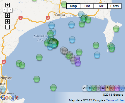
There has been a swarm of quakes going on for about 16hrs or so in Hawke Bay, biggest in it was a 4.1 up till this one
dangerous spot, scene of the 1931 Mag 7.1 that destroyed Napier, which was the most destructive earthquake in NZ before the Christchurch 2011 6.3
I'm about a week behind with NZ quakes, been in L'Aquila for a week ( on the computer )
USGS not using NZDT I see I did a double take to see if there had been a 5.2 and a 4.8 or if they were the same quake, USGS an hour behind on the NZT
geez there are some high readings on the USGS phase data for this quake
6.0-6.3 near the bottom
where the heck is BYL??? Babylon?
I have a file somewhere with them all on it will have a looksee.
Ha!
Byron's Ledge, Hawaii,U.S.A. , 19.41200, -155.26000, 1059.0m
www.isc.ac.uk...
couldn't find it on my Excel file, time to update that!
No didn't feel anything!
USGS probably over estimated the mb
Geonet has 4.8009ML
Public ID 2013p142607
Universal Time February 22 2013 at 18:21:50
NZ Daylight Time Saturday, February 23 2013 at 7:21:50 am
Latitude, Longitude -39.38, 177.59
Intensity ? light
Focal Depth 67 km
Magnitude 4.8
Location 40 km south-east of Wairoa
Agency WEL(GNS_Primary)
Status ? reviewed
Quality ? best
www.geonet.org.nz...
There has been a swarm of quakes going on for about 16hrs or so in Hawke Bay, biggest in it was a 4.1 up till this one


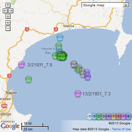
dangerous spot, scene of the 1931 Mag 7.1 that destroyed Napier, which was the most destructive earthquake in NZ before the Christchurch 2011 6.3
I'm about a week behind with NZ quakes, been in L'Aquila for a week ( on the computer )
USGS not using NZDT I see I did a double take to see if there had been a 5.2 and a 4.8 or if they were the same quake, USGS an hour behind on the NZT
edit on 22-2-2013 by muzzy because: (no reason given)
geez there are some high readings on the USGS phase data for this quake
6.0-6.3 near the bottom
where the heck is BYL??? Babylon?
I have a file somewhere with them all on it will have a looksee.
edit on 22-2-2013 by muzzy because: (no reason given)
Ha!
Byron's Ledge, Hawaii,U.S.A. , 19.41200, -155.26000, 1059.0m
www.isc.ac.uk...
couldn't find it on my Excel file, time to update that!
edit on 22-2-2013 by muzzy because: (no reason given)
Interesting area of occurrence...
quakes.globalincidentmap.com...
Type: Earthquake
111 minutes ago Magnitude: 2
DateTime: Friday February 22 2013, 19:31:46 UTC
Region: San Francisco Bay area, California
Depth: 9.7 km Source: USGS Feed
quakes.globalincidentmap.com...
Incoming???
MAP 5.2 2013/02/22 21:50:50 -15.805 -71.601 18.8 SOUTHERN PERU
MAP 5.2 2013/02/22 21:01:48 -15.773 -71.513 9.9 SOUTHERN PERU
MAP 4.9 2013/02/22 20:15:24 -15.701 -71.473 10.4 SOUTHERN PERU
Or just a reaction to the 6.1 in Argentina???
SOURCE: USGS
WOQ
MAP 5.2 2013/02/22 21:50:50 -15.805 -71.601 18.8 SOUTHERN PERU
MAP 5.2 2013/02/22 21:01:48 -15.773 -71.513 9.9 SOUTHERN PERU
MAP 4.9 2013/02/22 20:15:24 -15.701 -71.473 10.4 SOUTHERN PERU
Or just a reaction to the 6.1 in Argentina???
SOURCE: USGS
WOQ
Originally posted by wasobservingquietly
Incoming???
MAP 5.2 2013/02/22 21:50:50 -15.805 -71.601 18.8 SOUTHERN PERU
MAP 5.2 2013/02/22 21:01:48 -15.773 -71.513 9.9 SOUTHERN PERU
MAP 4.9 2013/02/22 20:15:24 -15.701 -71.473 10.4 SOUTHERN PERU
Or just a reaction to the 6.1 in Argentina???
SOURCE: USGS
WOQ
This could very well be a foreshock sequence....
Linked below is a list of Peru quakes going back to 1600.
I hope I am wrong!!
earthquake.usgs.gov...
Note the closest city....There were some sevens that shook the area in the 1950's.
earthquake.usgs.gov...
edit on 22-2-2013 by radpetey because: (no reason given)
Hope you are wrong too!.
Thats an interesting list, although I haven't gone back as far as the 1800's yet on my World7+ project, I do have 8+ on there and that Peru quake doesn't show as a 9.0
Date/Time: 1868/8/13 20:45:- UTC
Lat: -18.5 Long: -71
Location: Chile/Peru:Arica coast
Magnitude: 8.8 Mw
Depth: - km
Source: Ceresis (Centro Regional de Seismologia para America del Sur) (1985)
ah! ha! from the html source that page on USGS about the quake
after I did the 8+map!
nothing is "solution finalised" it seems, even after 144 years!
Thats an interesting list, although I haven't gone back as far as the 1800's yet on my World7+ project, I do have 8+ on there and that Peru quake doesn't show as a 9.0
Date/Time: 1868/8/13 20:45:- UTC
Lat: -18.5 Long: -71
Location: Chile/Peru:Arica coast
Magnitude: 8.8 Mw
Depth: - km
Source: Ceresis (Centro Regional de Seismologia para America del Sur) (1985)
ah! ha! from the html source that page on USGS about the quake
Page Last Modified: November 01, 2012 15:15:06 UTC
after I did the 8+map!
nothing is "solution finalised" it seems, even after 144 years!
reply to post by radpetey
This was the location that SpaceJockey had a premonition/dream about a Mag 9 quite some time back.
I don't have time to look back for it but it is there somewhere.
This was the location that SpaceJockey had a premonition/dream about a Mag 9 quite some time back.
I don't have time to look back for it but it is there somewhere.
Originally posted by PuterMan
reply to post by radpetey
This was the location that SpaceJockey had a premonition/dream about a Mag 9 quite some time back.
I don't have time to look back for it but it is there somewhere.
Yikes...!
A 9.0, 35km or less would decimate a goodly chunk of land in that area!!
Lets hope that premonition is just that.... a premonition!
I seem to remember that as well.
further to post by muzzy
USGS and GFZ obviously thought this Hawke BAy, NZ 4.8 yesterday was significant enough to create a MTS.
I still don't understand how those beach balls work.
Just when I thought I did they come out with some that don't match the basic models.
And they both had different shapes too.
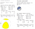
My understanding from this page all-geo.org... kindly posted here a short while back by someone, says that the USGS one is Transtension (extension+shear), but it is upside down
The GFZ one doesn't fit any of the 5 standard models at all
can anyone explain? or have a more comprehensive link where I can learn about this stuff?
USGS and GFZ obviously thought this Hawke BAy, NZ 4.8 yesterday was significant enough to create a MTS.
I still don't understand how those beach balls work.
Just when I thought I did they come out with some that don't match the basic models.
And they both had different shapes too.

My understanding from this page all-geo.org... kindly posted here a short while back by someone, says that the USGS one is Transtension (extension+shear), but it is upside down
The GFZ one doesn't fit any of the 5 standard models at all
can anyone explain? or have a more comprehensive link where I can learn about this stuff?
edit on 23-2-2013 by muzzy because: just doesn't look right without a line of green text explaining what grammatical error was made, missed a
space between letters this time
Santa Cruz on the up again
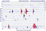
LISS SNZO graph
2013-02-23 14:31:04 5.7 11.67°S 165.06°E 10 A Santa Cruz Islands
2013-02-23 08:59:09 5.9 10.60°S 165.37°E 10 C Santa Cruz Islands
2013-02-22 22:22:06 5.2 11.11°S 165.68°E 10 A Santa Cruz Islands
geofon.gfz-potsdam.de...
LISS SNZO graph
edit on 23-2-2013 by muzzy because: add some colour
further further to post by muzzy
here is the swarm "iconized", as shown on 7days-2013-54 (i.e. coloured by magnitude)
[color=lime](click image for interactive map, opens in new tab/window)
hard to say when it actually started, if you look on NZ 30days Hawkes Bay is peppered with events back to 9-10 Feb when there was a 2 day gap, but the bulk of the quakes on this NW-SE "fault" mostly happened on the 22nd Feb UTC.
Note: these links above are only good for 7-30 days respectively, after that you need to look at 2013 All Quakes/month which are more permanent map links
popped the 1931 quake[s] in with the Feb22 file and thisswarm series is NE of the two biguns.
[color=lime](click image for interactive map, opens in new tab/window)
theres a bit of text on the popup tags on the 7's
7.8 and 7.3 jeepers no wonder Napier was destroyed
here is the swarm "iconized", as shown on 7days-2013-54 (i.e. coloured by magnitude)
[color=lime](click image for interactive map, opens in new tab/window)
hard to say when it actually started, if you look on NZ 30days Hawkes Bay is peppered with events back to 9-10 Feb when there was a 2 day gap, but the bulk of the quakes on this NW-SE "fault" mostly happened on the 22nd Feb UTC.
Note: these links above are only good for 7-30 days respectively, after that you need to look at 2013 All Quakes/month which are more permanent map links
edit on 23-2-2013 by muzzy because: (no reason given)
popped the 1931 quake[s] in with the Feb22 file and this
[color=lime](click image for interactive map, opens in new tab/window)
theres a bit of text on the popup tags on the 7's
7.8 and 7.3 jeepers no wonder Napier was destroyed
edit on 23-2-2013 by muzzy because: (no reason given)
Originally posted by PuterMan
reply to post by radpetey
This was the location that SpaceJockey had a premonition/dream about a Mag 9 quite some time back.
I don't have time to look back for it but it is there somewhere.
That's some memory you have their PM!
Feeling something building up for the region soon, possibly by middle-March.
BTW, that 3.9 in Arkansas about 20 min's ago strikes me as interesting...one-off or the start of something?
Originally posted by SpaceJockey1
Originally posted by PuterMan
reply to post by radpetey
This was the location that SpaceJockey had a premonition/dream about a Mag 9 quite some time back.
I don't have time to look back for it but it is there somewhere.
That's some memory you have their PM!
Feeling something building up for the region soon, possibly by middle-March.
BTW, that 3.9 in Arkansas about 20 min's ago strikes me as interesting...one-off or the start of something?
Man....I hope not. As I am 48 miles away from the southern end of that monster(NMSZ)
new topics
-
Does the Trump win mean No More Taylor Swift??
2024 Elections: 1 hours ago -
Trump-appointed judge blocks Biden administration overtime rule
Social Issues and Civil Unrest: 3 hours ago -
Don't cry do Cryo instead
General Chit Chat: 8 hours ago -
Tariffs all around, Except for ...
Dreams & Predictions: 10 hours ago
top topics
-
Gen Flynn's Sister and her cohort blow the whistle on DHS/CBP involvement in child trafficking.
Whistle Blowers and Leaked Documents: 14 hours ago, 8 flags -
Don't cry do Cryo instead
General Chit Chat: 8 hours ago, 8 flags -
Tariffs all around, Except for ...
Dreams & Predictions: 10 hours ago, 5 flags -
Does the Trump win mean No More Taylor Swift??
2024 Elections: 1 hours ago, 5 flags -
Anybody else using Pomodoro time management technique?
General Chit Chat: 17 hours ago, 4 flags -
Trump-appointed judge blocks Biden administration overtime rule
Social Issues and Civil Unrest: 3 hours ago, 4 flags
active topics
-
Don't cry do Cryo instead
General Chit Chat • 6 • : underpass61 -
Does the Trump win mean No More Taylor Swift??
2024 Elections • 5 • : watchitburn -
Tariffs all around, Except for ...
Dreams & Predictions • 15 • : worldstarcountry -
Trump-appointed judge blocks Biden administration overtime rule
Social Issues and Civil Unrest • 2 • : Dandandat3 -
Trump sues media outlets -- 10 Billion Dollar lawsuit
US Political Madness • 45 • : Oldcarpy2 -
Anybody else using Pomodoro time management technique?
General Chit Chat • 10 • : mysterioustranger -
Mike Tyson returns 11-15-24
World Sports • 56 • : Flyingclaydisk -
WATCH LIVE: US Congress hearing on UFOs, unidentified anomalous phenomena
Aliens and UFOs • 87 • : Lazy88 -
How can you defend yourself when the police will not tell you what you did?
Posse Comitatus • 86 • : ADVISOR -
The Acronym Game .. Pt.4
General Chit Chat • 963 • : JJproductions

