It looks like you're using an Ad Blocker.
Please white-list or disable AboveTopSecret.com in your ad-blocking tool.
Thank you.
Some features of ATS will be disabled while you continue to use an ad-blocker.
share:
reply to post by PuterMan
Another probably ignorant question for you and muzzy.
Here
www.iris.edu... zm=2&mt=ter&sz=large
Looking at the deeper quakes under the islands North of NZ . . . then following the slope from those deeper quakes up to NZ . . .
I'm not aware of the motions of the purported plates involved and am too keen to do other things to check . . . but I was wondering . . .
is there the least bit of a possibility that that slope from the deeper quakes North of NZ toward NZ could involve any . . . progressive . . . what . . .
maybe not movement in terms of massive mass movement of crust or land . . .
but perhaps waves of quakes from deeper up to the NZ area quakes?
Have you noticed any such waves of quakes sort of trends along that slope or line?
If this is too ignorant a question for your bother, I'll understand. No sweat.
BTW, THANKS BIG FOR THE ISRAEL QUAKE LINKS.
reply to post by BO XIAN
Not sure what you are suggesting, but the entire length from Cook Strait to Samoa is one big long edge of the Australia Plate, supposedly being subducted by the Pacific Plate. The various ridges to the west of the Kermadec Trough are remnants of old subduction edges ie Coleville Ridge was once where the Kermadec Ridge is now. Before that the Norfolk Ridge was the edge of the Plate.
The depths of earthquakes are pretty consistent along the length but the angle of decent may be different.
reply to post by Thebel
It's geothermal extraction, power generation system.
same as The Geysers in N. California
It's geothermal extraction, power generation system.
same as The Geysers in N. California
reply to post by muzzy
Ahhhhhhhhhhh . . . sounds like a sufficient explanation, to me.
What I was wondering . . . if I can articulate it any better . . . is . . .
Take that deepest quake near Samoa etc. Draw a line to Cook Strait.
IS IT THE CASE, or not, along that line
that quake frequency or energy released or sequencing
at all occur from that direction--from the deep Samoa area up to Cook Strait?
Is that a clearer question?
reply to post by donlashway
Thanks for the news update.
That's great news that no one was there to get injured during these quakes. Guess they must be thinking about the extra supplies to bring with them when they do go to make repairs if needed. Scientist that work in this type of environment are resourceful.
Thanks for the news update.
That's great news that no one was there to get injured during these quakes. Guess they must be thinking about the extra supplies to bring with them when they do go to make repairs if needed. Scientist that work in this type of environment are resourceful.
Magnitude 6.3 - Halmahera. Indonesia (267)
Location in Google Maps
- Date-Time: Tuesday, November 19, 2013 @ 13:32:54 UTC
- Earthquake location: 2.647°N, 128.402°E,
- Earthquake depth: 63.6 km
- Event ID: usb000l219
Derived from Event Data Source: USGS
Powered by QVSData
muzzy
reply to post by Thebel
It's geothermal extraction, power generation system.
same as The Geysers in N. California
Yes, I see. Pretty strong man made swarm. It appears to be in Brennisteinsfjöll system. Magma movement cannot be lined out though.
BO XIAN
reply to post by muzzy
Ahhhhhhhhhhh . . . sounds like a sufficient explanation, to me.
What I was wondering . . . if I can articulate it any better . . . is . . .
Take that deepest quake near Samoa etc. Draw a line to Cook Strait.
IS IT THE CASE, or not, along that line
that quake frequency or energy released or sequencing
at all occur from that direction--from the deep Samoa area up to Cook Strait?
Is that a clearer question?
As far as I can assertain, it is only the energy released that ties together, and only as far as the Kermadec Islands, if you recall the theory of the energy drop off below 10TTNT in New Zealand just about always results in a M5+ within 2-5 days anywhere along that line.
Having said that we do feel big quakes from the Tonga area here in Cook Strait (M7.6+)
I have seen no "quake frequency" or "sequencing" relationship here, or anywhere else on the Planet for that matter, its all pretty random. That sort of stuff seems to be confined to small areas of 300km square and is very long term (decades)
Getting a bit bumpy out there
Prov,Date/Time UTC,Latitude,Longitude,Magnitude,Depth(Km),Location
usgs,2013-11-19 13:32:51, 2.689, 128.460, 6.1, 38.7, Halmahera. Ind. (267)
gfzp,2013-11-19 13:32:53, 2.730, 128.460, 6.0, 51.0, Halmahera. Ind.
emsc,2013-11-19 13:32:55, 2.702, 128.426, 6.1, 66.0, Halmahera Ind.
gfzp,2013-11-19 15:16:48, 8.860, 138.510, 6.0, 10.0, W. Caroline Isls. Micronesia
usgs,2013-11-19 15:16:48, 8.947, 138.559, 5.7, 10.0, W. Caroline Isls. Micronesia (209)
emsc,2013-11-19 15:16:48, 8.860, 138.615, 5.8, 10.0, State Of Yap Micronesia
gfzp,2013-11-19 17:00:44, 18.470, 145.240, 6.0, 506.0, Mariana Isls.
emsc,2013-11-19 17:00:44, 18.494, 145.296, 6.0, 516.0, Pagan Reg. N. Mariana Isls.
usgs,2013-11-19 17:00:44, 18.457, 145.165, 5.9, 519.8, Mariana Isls. (216)
edit on 19/11/2013 by PuterMan because: (no reason given)
Japan
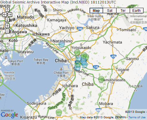
Chiba aftershocks of the 16/11/2013 M5.5 seem to be settling down
(click image for interactive map, opens in new tab/window)

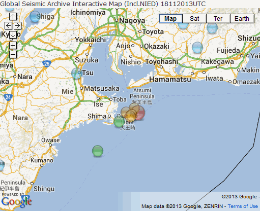
But a "strong" deep one offshore Toba
Date/ Time UTC, Latitude, Longitude, Magnitude, M-Type, Depth(Km), Location, Network
18/11/2013 19:10:45, 34.36, 137.01, 5.6, M, 325, Near S. Coast of Honshu, gfzp
18/11/2013 19:10:45, 34.3255, 137.0563, 5.7, Mw, 332, Near S. Coast of Honshu, emsc
18/11/2013 19:10:45, 34.3396, 137.0733, 5.7, mwb, 332.42, 25km SE of Toba, usgs
18/11/2013 19:11:00, 34.4, 137.1, 5.7, M, 350, Enshu-nada, jma
18/11/2013 19:10:44, 34.355, 137.1394, 6.1, ML, 353.9, Near S. Coast Of Honshu, nied
(click image for interactive map, opens in new tab/window)

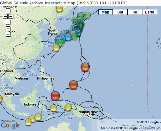
zoom out of either GMap for all GSAIM quakes 18/11/2013
Chiba aftershocks of the 16/11/2013 M5.5 seem to be settling down
(click image for interactive map, opens in new tab/window)

But a "strong" deep one offshore Toba
Date/ Time UTC, Latitude, Longitude, Magnitude, M-Type, Depth(Km), Location, Network
18/11/2013 19:10:45, 34.36, 137.01, 5.6, M, 325, Near S. Coast of Honshu, gfzp
18/11/2013 19:10:45, 34.3255, 137.0563, 5.7, Mw, 332, Near S. Coast of Honshu, emsc
18/11/2013 19:10:45, 34.3396, 137.0733, 5.7, mwb, 332.42, 25km SE of Toba, usgs
18/11/2013 19:11:00, 34.4, 137.1, 5.7, M, 350, Enshu-nada, jma
18/11/2013 19:10:44, 34.355, 137.1394, 6.1, ML, 353.9, Near S. Coast Of Honshu, nied
(click image for interactive map, opens in new tab/window)

zoom out of either GMap for all GSAIM quakes 18/11/2013
reply to post by PuterMan
Ha I'm 12 hrs ahead, but half a day behind with the daily GSAIM maps.
Should we be doing a partial day? this seems to be my new default time to be doing the downloads off NIED and QVS DataPro. (5-7am NZST)
I just loaded the latest NIED data to that Dropbox file I sent you a link to, if you want to have a crack at it, I'm off to work now..............
edit on 11u32232213 by muzzy because: (no reason given)
reply to post by muzzy
Oh well, here ya are, the Philippine Plate triple 6's
(click image for interactive map, opens in new tab/window)

Oh well, here ya are, the Philippine Plate triple 6's
(click image for interactive map, opens in new tab/window)

2:48am, can't sleep, Full Moon
Pac-Ant Ridge was doing its nut yesterday (NZDT)
map
Scott Base IRIS webicorder 19th UTC
Scott Base IRIS webicorder 20th UTC
Pac-Ant Ridge was doing its nut yesterday (NZDT)
WHEN (UTC), LAT, LONG, DEPTH, MAG, WHERE
20/11/2013 3:57:12, -57.25, -150.75, 33, 5, PACIFIC-ANTARCTIC RIDGE
20/11/2013 3:45:28, -63.75, -164.75, 33, 5.3, PACIFIC-ANTARCTIC RIDGE
20/11/2013 2:39:44, -63.75, -164.25, 33, 4.8, PACIFIC-ANTARCTIC RIDGE
19/11/2013 23:18:00, -63.75, -165.75, 33, 5.8, PACIFIC-ANTARCTIC RIDGE
19/11/2013 23:02:00, -63.75, -166.25, 33, 5.2, PACIFIC-ANTARCTIC RIDGE
19/11/2013 22:13:04, -63.5, -164.5, 33, 5.4, PACIFIC-ANTARCTIC RIDGE
www.ldeo.columbia.edu...
map
Scott Base IRIS webicorder 19th UTC
Scott Base IRIS webicorder 20th UTC
edit on 1100000032332313 by muzzy because: (no reason given)
dfw.cbslocal.com...
www.edmondsun.com...
www.reuters.com...
blah blah blah , injection wells everywhere.
let's blame the lake or nature or crab people.
www.myfoxdfw.com...
earthquake-report.com...
www.ocolly.com...
www.edmondsun.com...
www.reuters.com...
blah blah blah , injection wells everywhere.
let's blame the lake or nature or crab people.
www.myfoxdfw.com...
earthquake-report.com...
www.ocolly.com...
edit on 20-11-2013 by ericblair4891 because: (no reason given)
reply to post by ericblair4891
Well judging by Earthquake Reports' new logo, Putermans prediction has come to pass ...............
the bottom of the Earth has finally fallen off after those Scotia Sea quakes
earthquake-report.com...

Nah, I believe we are still here!
Well judging by Earthquake Reports' new logo, Putermans prediction has come to pass ...............
the bottom of the Earth has finally fallen off after those Scotia Sea quakes
earthquake-report.com...

Nah, I believe we are still here!
reply to post by ericblair4891
From one of Eric's articles:
Oklahoma has 11,000 INJECTION wells!!!
Whaaaat!!!!
And how many altogether with extraction ones???
www.reuters.com...
The Midwest: Land of Swiss cheese! Literally!!!
WOQ wonders if this is the most of any state,
but is too upset to try & find out!
For right now, don't want to know...don't think I could take the truth!
Walks away sadly shaking head & wiping away some stray tears!
F*R*A*C*K*I*N*G I*D*I*O*T*S!!! SIGH!!!
WOQ
edit on 20-11-2013 by wasobservingquietly because: (no reason given)
Ohio now?
M3.5 - 4km ESE of Nelsonville, Ohio
2013-11-20 17:59:40 UTC
Event Time
2013-11-20 17:59:40 UTC
2013-11-20 12:59:40 UTC-05:00 at epicenter
2013-11-20 09:59:40 UTC-08:00 system time
Location
39.439°N 82.190°W depth=7.9km (4.9mi)
Nearby Cities
4km (2mi) ESE of Nelsonville, Ohio
14km (9mi) NNW of Athens, Ohio
46km (29mi) SE of Lancaster, Ohio
56km (35mi) WNW of Vienna, West Virginia
90km (56mi) SE of Columbus, Ohio
earthquake.usgs.gov...
edit on 7/30/2012 by dreamfox1 because: (no reason given)
M 2.1
- 11km SSW of Ridgely, Tennessee
2013-11-20 19:39:14 UTC
Event Time
2013-11-20 19:39:14 UTC
2013-11-20 13:39:14 UTC-06:00 at epicenter
2013-11-20 11:39:14 UTC-08:00 system time
Location
36.168°N 89.522°W depth=0.4km (0.2mi)
earthquake.usgs.gov...
- 11km SSW of Ridgely, Tennessee
2013-11-20 19:39:14 UTC
Event Time
2013-11-20 19:39:14 UTC
2013-11-20 13:39:14 UTC-06:00 at epicenter
2013-11-20 11:39:14 UTC-08:00 system time
Location
36.168°N 89.522°W depth=0.4km (0.2mi)
earthquake.usgs.gov...
M3.5
- 29km NNE of Redway, California
2013-11-21 00:48:54 UTC
Event Time
2013-11-21 00:48:54 UTC
2013-11-20 16:48:54 UTC-08:00 at epicenter
2013-11-20 16:48:54 UTC-08:00 system time
Location
40.374°N 123.719°W depth=29.6km (18.4mi)
Nearby Cities
29km (18mi) NNE of Redway, California
44km (27mi) SE of Fortuna, California
59km (37mi) SSE of Bayside, California
60km (37mi) SE of Eureka, California
276km (171mi) NW of Sacramento, California
earthquake.usgs.gov...
new topics
-
Lies lies lies, green energy is black.
The Gray Area: 2 hours ago -
Ford Motor Company sold to Elon Musk
Other Current Events: 6 hours ago -
President Biden pardons his son Hunter Biden
US Political Madness: 10 hours ago -
Biden pardons his son Hunter despite previous pledges not to
Mainstream News: 10 hours ago
top topics
-
Biden pardons his son Hunter despite previous pledges not to
Mainstream News: 10 hours ago, 14 flags -
President Biden pardons his son Hunter Biden
US Political Madness: 10 hours ago, 11 flags -
Salvatore Pais confirms science in MH370 videos are real during live stream
General Conspiracies: 15 hours ago, 5 flags -
Studies show that watching a beaver eat cabbage lowers stress by 17%
Health & Wellness: 14 hours ago, 5 flags -
Lies lies lies, green energy is black.
The Gray Area: 2 hours ago, 2 flags -
Ford Motor Company sold to Elon Musk
Other Current Events: 6 hours ago, 0 flags
active topics
-
Mass UAP events. DC. Machester Airport, UFOs over sub base in CT, Nuke bases.
Aliens and UFOs • 47 • : Lazy88 -
Biden pardons his son Hunter despite previous pledges not to
Mainstream News • 48 • : SprocketUK -
James Webb Telescope Takes a Look at the Sombrero Galaxy
Space Exploration • 17 • : SprocketUK -
Salvatore Pais confirms science in MH370 videos are real during live stream
General Conspiracies • 18 • : crayzeed -
Australia passes social media ban for children under 16
Social Issues and Civil Unrest • 14 • : SprocketUK -
Tomorrow will be the 7th day after the election, and they are still counting
US Political Madness • 51 • : Flyingclaydisk -
Lies lies lies, green energy is black.
The Gray Area • 4 • : Flyingclaydisk -
Ford Motor Company sold to Elon Musk
Other Current Events • 5 • : DaRAGE -
Assad flees to moscow
World War Three • 43 • : Flyingclaydisk -
Post A Funny (T&C Friendly) Pic Part IV: The LOL awakens!
General Chit Chat • 7856 • : angelchemuel

