It looks like you're using an Ad Blocker.
Please white-list or disable AboveTopSecret.com in your ad-blocking tool.
Thank you.
Some features of ATS will be disabled while you continue to use an ad-blocker.
share:
further to post by muzzy
and 2nd reply to post by pheonix358
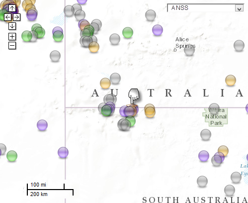
Looked a bit closer at that list, and expanded the parameters to
start_time=1800/01/01,00:00:00, end_time=2013/06/13,00:00:00
polygon=-16.1,124.4,-16.1,141.0,-30.2,141.0,-30.2,124.4,-16.1,124.4
basically the area known as "The Centre"
results back give 323 earthquakes
17/01/1965 02:48:33 to 09/06/2013 14:22:13
 [color=8BB381](click image for interactive map, opens in new tab/window,)
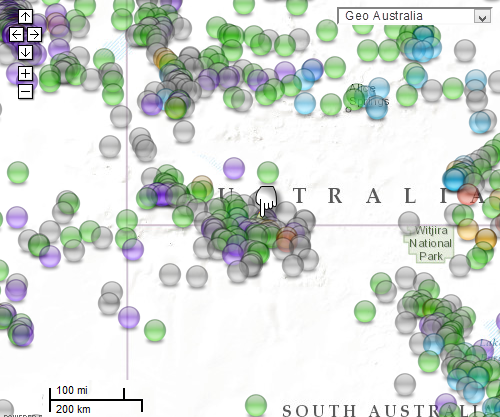
same parameters, Geoscience Australia
obviously more results, 2680 events
28/10/1937 09:34:43 to 12/06/2013 13:30:39
 [color=8BB381](click image for interactive map, opens in new tab/window)
I didn't notice before, only 110km from Uluru (Ayers Rock)
and 2nd reply to post by pheonix358
Looked a bit closer at that list, and expanded the parameters to
start_time=1800/01/01,00:00:00, end_time=2013/06/13,00:00:00
polygon=-16.1,124.4,-16.1,141.0,-30.2,141.0,-30.2,124.4,-16.1,124.4
basically the area known as "The Centre"
results back give 323 earthquakes
17/01/1965 02:48:33 to 09/06/2013 14:22:13

same parameters, Geoscience Australia
obviously more results, 2680 events
28/10/1937 09:34:43 to 12/06/2013 13:30:39

I didn't notice before, only 110km from Uluru (Ayers Rock)
edit on 12-6-2013 by muzzy because: I stuffed up the GeoAu download and didn't get the N of Stations, to late to go back and do it again,
first time I've done a GeoAu download with parameters, will do better next time
edit on 12-6-2013 by muzzy because: @ pheonix358. so
there you go, nothing silly about it at all
reply to post by muzzy
Indian Geophysical and Geological Survey.
I don't understand why 1800 because were only two stations working back then and both were the property of IGGS.
start_time=1800/01/01,00:00:00,
Indian Geophysical and Geological Survey.
reply to post by piequal3because14
colonisation by non convicts began in 1793, I gave them 7 years leeway to start moving inland and record what they saw/felt.
I was a bit surprised no earthquakes recorded prior to 1937, here in NZ the first quake recorded was on 10th May 1773.
colonisation by non convicts began in 1793, I gave them 7 years leeway to start moving inland and record what they saw/felt.
I was a bit surprised no earthquakes recorded prior to 1937, here in NZ the first quake recorded was on 10th May 1773.
reply to post by piequal3because14
They may have been sheep stations but I doubt if they were seismograph stations. Britain set up the first 'array' of relatively scientific seismometers in 1844 and promptly forgot about them when the earthquakes stopped.
There were earlier 'instruments'
I think USGS may still be using these
Go back and forwards reading those pages (arrows at the bottom) - quite interesting.
It would be fair to say I think that really seismometers with any degree of accuracy did not happen until the 1900s and particular when Charles Richter got involved with the Wood-Anderson seismometer - you will have to look elsewhere for details on that.
reply to post by muzzy
Did you? By gum I knew thee was old, but not that old!
only two stations working back then
They may have been sheep stations but I doubt if they were seismograph stations. Britain set up the first 'array' of relatively scientific seismometers in 1844 and promptly forgot about them when the earthquakes stopped.
There were earlier 'instruments'
n the years immediately following the Calabrian earthquakes, two other seismic instruments were described which should be mentioned here. A. Cavalli, in 1784, reinvented de la Haute Feuille's mercury-filled-bowl seismoscope (Cavalli, 1785). In addition, he designed a modification of this instrument which would give the time of an earthquake, to the nearest minute. This was to be accomplished by the use of platforms rotating beneath two mercury-filled bowls. As the platforms rotated, cavities corresponding respectively to the hour of the day and the minute of the hour would pass beneath the notches in the sides of the bowls. When mercury overflowed from the bowls through the notches, it would be conveyed into the two cavities corresponding to the hour and minute of the day. The observations reported by Cavalli suggest that the time-telling part of his seismoscope was never built (Cavalli, 1785). This instrument, if it was constructed, was the first designed to tell the time of an earthquake.
I think USGS may still be using these
Go back and forwards reading those pages (arrows at the bottom) - quite interesting.
It would be fair to say I think that really seismometers with any degree of accuracy did not happen until the 1900s and particular when Charles Richter got involved with the Wood-Anderson seismometer - you will have to look elsewhere for details on that.
reply to post by muzzy
colonisation by non convicts began in 1793, I gave them 7 years leeway to start moving inland
Did you? By gum I knew thee was old, but not that old!
edit on 13/6/2013 by PuterMan because: To add MOAR!
Originally posted by PuterMan
I think USGS may still be using these
This made me spit my coffee! You're a humorous fellow, Mr. Puterman.
I know I always think this, but,,,,, does it seem "quiet", seismically speaking, to anyone else?
Statistically, we are above average for Mag 8+ earthquakes for the year (2 since Jan. 1st), and Mag 7+ look to be on track to be average, too (USGS search gives 8, year-to-date. 15/year is average)
Maybe it just seems quiet because there haven't been many posts in here recently....
reply to post by muzzy
Let me be the first to mention that Pine Gap isn't overly far away in Australian terms
reply to post by muzzy
Let me be the first to mention that Pine Gap isn't overly far away in Australian terms
reply to post by etrex66
For those with their heads buried in seismos (what me? nooooo) Pine gap is where reputedly there has been greatUnited States
Unidentified Flying Object activity and close contact between the Americans and the Aliens
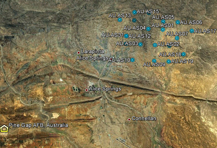
You can see the location here
Rather interestingly the nice clear image of the tunnel entrance a little south of that location has been replaced with one full of clouds and you can't see the entrance any more. Mm.
At about 620 km distance from the 3.4 quake and 303 km from the 5.7 it is certainly not too far and within accuracy range for Richter scales. There is, beside the AFB at Alice Springs, a seismo station, or rather an array. This is obviously placed there to monitorlandings
earthquakes in the quarry/landing zone/whatever area or Aboriginal dances on Uluru.

As usual I am a mine of useless information.
For those with their heads buried in seismos (what me? nooooo) Pine gap is where reputedly there has been great
You can see the location here
Rather interestingly the nice clear image of the tunnel entrance a little south of that location has been replaced with one full of clouds and you can't see the entrance any more. Mm.
At about 620 km distance from the 3.4 quake and 303 km from the 5.7 it is certainly not too far and within accuracy range for Richter scales. There is, beside the AFB at Alice Springs, a seismo station, or rather an array. This is obviously placed there to monitor

As usual I am a mine of useless information.
M6.7 - 170km ENE of Flying Fish Cove, Christmas Island
2013-06-13 16:47:23 UTC
Event Time
2013-06-13 16:47:23 UTC
2013-06-13 23:47:23 UTC+07:00 at epicenter
2013-06-13 11:47:23 UTC-05:00 system time
Location
10.030°S 107.182°E depth=11.1km (6.9mi)
Nearby Cities
170km (106mi) ENE of Flying Fish Cove, Christmas Island
313km (194mi) SSW of Kawalu, Indonesia
313km (194mi) SSW of Singaparna, Indonesia
314km (195mi) S of Banjar, Indonesia
423km (263mi) S of Jakarta, Indonesia
USGS
I just hope this are no foreshocks, I have some friends living on the Indonesian coast and a tsunami is the last thing they need
www.ldeo.columbia.edu/~ekstrom/Research/SWD/current/RADB_SWD_grd.html
GSRAS only the first
www.ceme.gsras.ru/cgi-bin/quake_state.pl?sta=20132238

2013 6 13 11 55 44.0 58.25 -32.25 33.0 4.9 REYKJANES RIDGE
2013 6 13 10 8 40.0 58.25 -31.75 33.0 4.8 REYKJANES RIDGE
GSRAS only the first
www.ceme.gsras.ru/cgi-bin/quake_state.pl?sta=20132238

reply to post by PuterMan
They certainly use them.
After so many generation they have genetically adapted to feel earthquakes and analyze them,even with the posibility of making an maaaaehehe graph,with a very long sound when downgrading one.
Oh and....lately I heard this story about two good friends,an grumpy and a skeptikal walking together on the streets of a small town.
The grumpy ask the skeptical "Tell me my friend, do you think that tomorrow we will have a big earthquake?"
'No!',answer the skeptikal.
"But why is that? last time when I asked you you told me yes,and within an hour we had one,a big one."
'Yes',answer the skeptical,'but last time you gave me to drink an entire bottle of Irish scotch.'
moral of the story:
Never give to a skeptical Irish scotch because,Irish scoth can be the best earthquake predictor.
You mean the sheep stations?
I think USGS may still be using these
They certainly use them.
After so many generation they have genetically adapted to feel earthquakes and analyze them,even with the posibility of making an maaaaehehe graph,with a very long sound when downgrading one.
Oh and....lately I heard this story about two good friends,an grumpy and a skeptikal walking together on the streets of a small town.
The grumpy ask the skeptical "Tell me my friend, do you think that tomorrow we will have a big earthquake?"
'No!',answer the skeptikal.
"But why is that? last time when I asked you you told me yes,and within an hour we had one,a big one."
'Yes',answer the skeptical,'but last time you gave me to drink an entire bottle of Irish scotch.'
moral of the story:
Never give to a skeptical Irish scotch because,Irish scoth can be the best earthquake predictor.
edit on 13-6-2013 by piequal3because14
because: use them
reply to post by piequal3because14
Um no
I am a grumpy and a sceptical - can I have a bottle of scotch please so i can do some predicting?
Um no
platforms rotating beneath two mercury-filled bowls. As the platforms rotated, cavities corresponding respectively to the hour of the day and the minute of the hour would pass beneath the notches in the sides of the bowls. When mercury overflowed from the bowls through the notches, it would be conveyed into the two cavities corresponding to the hour and minute of the day.
I am a grumpy and a sceptical - can I have a bottle of scotch please so i can do some predicting?
edit on 13/6/2013 by PuterMan because: (no reason given)
reply to post by PuterMan

www.foxnews.com...
for this

www.microcosmologist.com...
Um yes,

theblackberryalarmclock.com...
I am a grumpy and a sceptical - can I have a bottle of scotch please so i can do some predicting?

www.foxnews.com...
for this

www.microcosmologist.com...
Um no
Um yes,

theblackberryalarmclock.com...
reply to post by piequal3because14
I had done a nice response to you but ATS decided to log me out in between starting and finishing the post.
Basically without going all through it again, thanks for the whiskey and point taken on the wine but i have to disagree on the sheep. The articles you linked give no information on the ability of sheep to detect earthquakes through their feet.
As far as I can find the only contribution that sheep have make in their 6000 year history of domestication is the concatenation of the two ovine quake scales maa and baa into a single scale we now know as mb (maa + baa) which is mainly applied to the smaller earthquakes as sheep were/are not big enough to register anything larger. The creation of this scale is celebrated on the 15th February in New Zealand.
This is strange.
I was checking out the particulars on this small earthquake that is located well offshore of the Oregon coast. Mag 2.8 13 June 2013 @ 18:11:21 UTC.
We all know the PNSN does the best they can to locate these offshore quakes, but this one must have been unusually confounding; location uncertainty: 99 km., depth uncertainty: 31.6 km.
Then I looked up the same quake on the PNSN website, here.
Whaaaatt is a Mag -5.0 Mh?
Magnitude heckifweknow?
They moved the location a bit farther north & west, and the depth is only 5 km.
I really hope when the ocean bottom seismometer data is pulled, they have time to use it to fine tune the locations of all of the near shore and offshore quakes in the PNW. It will go a long way to better understanding what is happening in the subduction zone.
(It appears that the 1st 2012 data from the OSB Cascadia Initiative is available--at the bottom of this linked page)
ETA: I found the elusive Mh magnitude at SCSN faq pages.
Apparently, it is the seismologist's "eyeball" guess, based on the visual estimates of coda duration, or amplitude ratios to similarly located earthquakes.
I was checking out the particulars on this small earthquake that is located well offshore of the Oregon coast. Mag 2.8 13 June 2013 @ 18:11:21 UTC.
We all know the PNSN does the best they can to locate these offshore quakes, but this one must have been unusually confounding; location uncertainty: 99 km., depth uncertainty: 31.6 km.
Then I looked up the same quake on the PNSN website, here.
Whaaaatt is a Mag -5.0 Mh?
Magnitude heckifweknow?
They moved the location a bit farther north & west, and the depth is only 5 km.
I really hope when the ocean bottom seismometer data is pulled, they have time to use it to fine tune the locations of all of the near shore and offshore quakes in the PNW. It will go a long way to better understanding what is happening in the subduction zone.
(It appears that the 1st 2012 data from the OSB Cascadia Initiative is available--at the bottom of this linked page)
edit on 6/14/2013 by Olivine because: (no reason given)
edit on 6/14/2013 by Olivine because: change from PG-13 wording to
G
ETA: I found the elusive Mh magnitude at SCSN faq pages.
Apparently, it is the seismologist's "eyeball" guess, based on the visual estimates of coda duration, or amplitude ratios to similarly located earthquakes.
edit on 6/14/2013 by Olivine because: add more words
reply to post by PuterMan
Oh,first I have a feeling we are watched.

www.dailymail.co.uk...
And I am afraid....
The scales maa and baa are very true and it is a pleasant surprise for me that finally someone has brought this to public attention.
But in the same time The S wave and the P wave are brought by the same SheeP when they 'hee'.
from the same country New Zeeland.

inhabitat.com...
Oh and I appologise to Olivine if we interefered in something important here in this thread.

www.dailymail.co.uk...
And I am afraid....
As far as I can find the only contribution that sheep have make in their 6000 year history of domestication is the concatenation of the two ovine quake scales maa and baa into a single scale we now know as mb (maa + baa) which is mainly applied to the smaller earthquakes as sheep were/are not big enough to register anything larger. The creation of this scale is celebrated on the 15th February in New Zealand.
The scales maa and baa are very true and it is a pleasant surprise for me that finally someone has brought this to public attention.
But in the same time The S wave and the P wave are brought by the same SheeP when they 'hee'.
from the same country New Zeeland.

inhabitat.com...
Oh and I appologise to Olivine if we interefered in something important here in this thread.
reply to post by piequal3because14
Nope, your conversation with the P-man is not interrupting me. Continue on....baa
Reading more about the 1st batch of data available from the OBS project, it looks as if continuous data is located in IRIS, here, ready for download in batches.
...well most of it....read on...
From the Cascadia 1st Year Product pdf, I found this interesting bit:
I suppose the National Science Foundation is used to having their dollars and initiatives pilfered by the military...
Nope, your conversation with the P-man is not interrupting me. Continue on....baa
Reading more about the 1st batch of data available from the OBS project, it looks as if continuous data is located in IRIS, here, ready for download in batches.
...well most of it....read on...
From the Cascadia 1st Year Product pdf, I found this interesting bit:
The year 1 OBS deployments were successful; 22 of 23 WHOI, 10 of 19 LDEO, and 12 of 15 SIO stations operated normally during the deployment period. Of note, BH and HH data channels are missing common segments (~10% of the data, depending on the station) that are redacted by the U.S. Navy.
I suppose the National Science Foundation is used to having their dollars and initiatives pilfered by the military...
Came across this and found it interesting. Thought some here may want to take a peek.
www.abovetopsecret.com...
P
www.abovetopsecret.com...
P
Magnitude 6.0 - South Of The Kermadec Islands
Location in Google Maps
- Date-Time: Saturday, June 15, 2013 @ 11:20:34 UTC
- Earthquake location: 33.895°S, 179.455°E,
- Earthquake depth: 172.4 km
- Distances:
313km (194mi) SSW of L'Esperance Rock, New Zealand
502km (311mi) NNE of Whakatane, New Zealand
511km (317mi) ENE of Whangarei, New Zealand
514km (319mi) NE of Tauranga, New Zealand
918km (570mi) NNE of Wellington, New Zealand
- Event ID: usc000hrgh
Derived from Event Data Source: USGS
Powered by QVSData
however .....
Everyone else has 5.8 at present
How jolly! Everyone now agrees except New Zealand.
2013-06-15 11:20:38, -34.804, 179.908, 5.4, 307.3, South Of Kermadec Isls. [Map]
edit on 15/6/2013 by PuterMan because: (no reason given)
new topics
-
Green Grapes
General Chit Chat: 2 hours ago -
Those Great Fresh Pet Commercials
Television: 7 hours ago -
S.C. Jack Smith's Final Report Says Trump Leads a Major Conspiratorial Criminal Organization!.
Political Conspiracies: 9 hours ago -
Advice for any young Adult .
General Chit Chat: 10 hours ago -
Joe meant what he said about Hunter's pardon....
US Political Madness: 11 hours ago
top topics
-
Joe meant what he said about Hunter's pardon....
US Political Madness: 11 hours ago, 11 flags -
S.C. Jack Smith's Final Report Says Trump Leads a Major Conspiratorial Criminal Organization!.
Political Conspiracies: 9 hours ago, 11 flags -
Steering the Titantic from the Drydock.
Rant: 16 hours ago, 10 flags -
Advice for any young Adult .
General Chit Chat: 10 hours ago, 10 flags -
Green Grapes
General Chit Chat: 2 hours ago, 5 flags -
It’s Falling…
Philosophy and Metaphysics: 13 hours ago, 4 flags -
Regent Street in #London has been evacuated due to a “bomb threat.”
Other Current Events: 12 hours ago, 3 flags -
Those Great Fresh Pet Commercials
Television: 7 hours ago, 3 flags
active topics
-
Those stupid GRAVITE commercials
Rant • 13 • : GENERAL EYES -
Los Angeles brush fires latest: 2 blazes threaten structures, prompt evacuations
Mainstream News • 95 • : xuenchen -
-@TH3WH17ERABB17- -Q- ---TIME TO SHOW THE WORLD--- -Part- --44--
Dissecting Disinformation • 3973 • : duncanagain -
What Comes After January 20th
Mainstream News • 31 • : xuenchen -
Green Grapes
General Chit Chat • 1 • : nugget1 -
Those Great Fresh Pet Commercials
Television • 4 • : BingoMcGoof -
My personal experiences and understanding of orbs
Aliens and UFOs • 39 • : Compendium -
S.C. Jack Smith's Final Report Says Trump Leads a Major Conspiratorial Criminal Organization!.
Political Conspiracies • 39 • : WeMustCare -
Joe meant what he said about Hunter's pardon....
US Political Madness • 10 • : rickymouse -
Steering the Titantic from the Drydock.
Rant • 42 • : Drugstorecowboy56
