It looks like you're using an Ad Blocker.
Please white-list or disable AboveTopSecret.com in your ad-blocking tool.
Thank you.
Some features of ATS will be disabled while you continue to use an ad-blocker.
share:
These are recent plottings of ranges of EQs in the CSZ, one is the last two + months and I cant remember the other shorter one.
I believe they illustrate whats going on beneath the North American plate where JDF/Gorda has subducted.
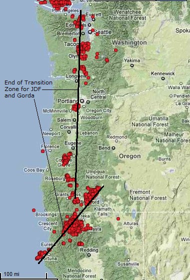
The first one (and 1b) shows the general common distribution of EQs, and the end of the transition zone, where the plate is actively subducting. For the JDF this is basically due south and for the Gorda one can see the clockwise motion.
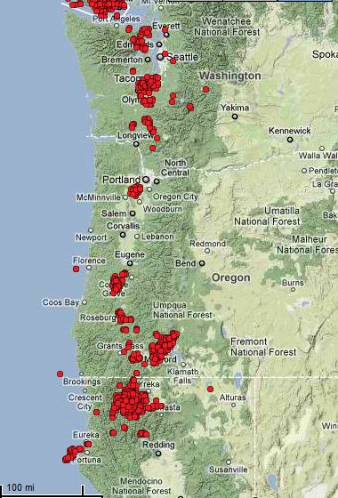
1b
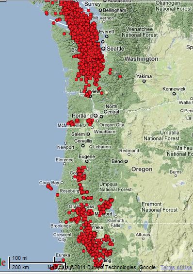
And this one for the last 2+ months shows almost no activity whatsoever in the central Oregon area. Not sure what its saying really. That area is historically less active, but not dead quiet.
I believe they illustrate whats going on beneath the North American plate where JDF/Gorda has subducted.
The first one (and 1b) shows the general common distribution of EQs, and the end of the transition zone, where the plate is actively subducting. For the JDF this is basically due south and for the Gorda one can see the clockwise motion.

1b

And this one for the last 2+ months shows almost no activity whatsoever in the central Oregon area. Not sure what its saying really. That area is historically less active, but not dead quiet.

reply to post by zworld
Just to clarify these are not what you would call a typical earthquake but a deep tremor:
source with great info
source for map
Just to clarify these are not what you would call a typical earthquake but a deep tremor:
In 2001, CWU researchers with the continuous GPS network Pacific Northwest Geodetic Array discovered periodic slow-slip across the Cascadia Subduction Zone. Previously undetected by seismic networks, these slip events exhibit regular recurrence intervals thus changing current understanding of earthquake behavior. Since this time, definitions for this newly discovered phenomenon have evolved. At first, the term "silent-earthquake" was employed to illustrate the absence of a seismic signature. Subsequent investigations and recent discoveries have led to a change in characterization. Now these slow-slip events are defined as eposodic tremor and slip (ETS).
In short, an ETS is a discreet time interval (episode) of relative tectonic plate movement (slip) coupled with high frequency seismic energy bursts (tremor). ETS usually last for around a few weeks duration as opposed to regular earthquakes where energy is released within seconds to minutes.
source with great info
source for map
reply to post by westcoast
Thanks for posting the source WC. I keep forgetting to cite stuff.
Ive never paid attention to the north end of the CSZ. Im amazed at the number of tremors youze guyze have up there. That must be some of the recent ETS event that just ended.
And I should have added above that these are all 1-3M quakes and not noticed above ground.
I should also add that these small quakes do not take pressure off the locked zones, and in fact may be increasing it. These quakes represent the subducted slab moving further from the locked portion, creating elastic stress I believe.
reply to post by zworld
Yup....it is most interesting. A big part of my theories. Check out the link in my sig for 'another slow tremor moving beneath the olympic peninsula'. I go into a lot of detail on what it is (in theory)...and I have a more recent thread for the ETS that just occured!
Yup....it is most interesting. A big part of my theories. Check out the link in my sig for 'another slow tremor moving beneath the olympic peninsula'. I go into a lot of detail on what it is (in theory)...and I have a more recent thread for the ETS that just occured!
5.3 (EU) or 5.9 (USGS) in the southern JDF just north of the Gorda Plate. Conflicting data on depth as well.
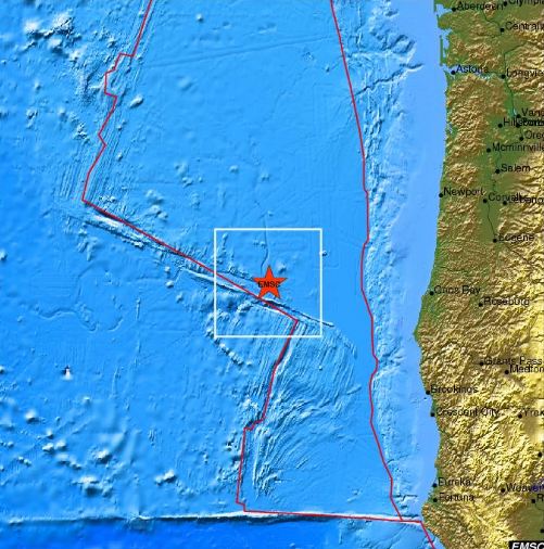
# Magnitude: 5.9
# Time (UTC):2011/10/13 04:13:59
# Time (Local):Wed Oct 12, 2011 21:13:59 PDT
# Depth (Km): 10.0
Magnitude 5.3
Region OFF COAST OF OREGON
Date time 2011-10-13 04:14:00.0 UTC
Location 43.49 N ; 127.13 W
Depth 15 km
Distances 329 km W Eugene (pop 145,208 ; local time 21:14:00.0 2011-10-12)
234 km W Coos bay (pop 15,394 ; local time 21:14:00.0 2011-10-12)
224 km W Bandon (pop 2,830 ; local time 21:14:00.0 2011-10-12)
edit on 13-10-2011 by zworld because: (no reason given)
Magnitude
4.0
Date-Time
Monday, October 17, 2011 at 20:05:57 UTC
Monday, October 17, 2011 at 01:05:57 PM at epicenter
Location
34.697°N, 116.294°W
Depth
1.8 km (1.1 miles)
Region
SOUTHERN CALIFORNIA
Distances
13 km (8 miles) WSW (257°) from Ludlow, CA
40 km (25 miles) WNW (288°) from Bagdad, CA
53 km (33 miles) NNW (340°) from Twentynine Palms Base, CA
64 km (40 miles) N (10°) from Yucca Valley, CA
65 km (41 miles) NNW (342°) from Twentynine Palms, CA
193 km (120 miles) ENE (68°) from Los Angeles Civic Center, CA
Location Uncertainty
horizontal +/- 0.2 km (0.1 miles); depth +/- 0.5 km (0.3 miles)
Parameters
Nph= 62, Dmin=13 km, Rmss=0.22 sec, Gp= 36°,
M-type=local magnitude (ML), Version=1
Source
California Integrated Seismic Net:
USGS Caltech CGS UCB UCSD UNR
Event ID
ci15064556
earthquake.usgs.gov...
Where the hell is Middlebrook????????????????
Magnitude
2.0
Date-Time
Monday, October 17, 2011 at 20:14:44 UTC
Monday, October 17, 2011 at 01:14:44 PM at epicenter
Location
34.697°N, 116.289°W
Depth
3.2 km (2.0 miles)
Region
SOUTHERN CALIFORNIA
Distances
12 km (8 miles) WSW (257°) from Ludlow, CA
40 km (25 miles) WNW (289°) from Bagdad, CA
53 km (33 miles) NNW (340°) from Twentynine Palms Base, CA
65 km (40 miles) N (10°) from Yucca Valley, CA
65 km (40 miles) NNW (342°) from Twentynine Palms, CA
192 km (120 miles) SSW (210°) from Las Vegas, NV
Location Uncertainty
horizontal +/- 0.3 km (0.2 miles); depth +/- 0.6 km (0.4 miles)
Parameters
Nph= 29, Dmin=13 km, Rmss=0.2 sec, Gp= 54°,
M-type=local magnitude (ML), Version=0
Source
California Integrated Seismic Net:
USGS Caltech CGS UCB UCSD UNR
Event ID
ci15064564
earthquake.usgs.gov...
edit on 17-10-2011 by berkeleygal because: added more info
reply to post by berkeleygal
Yea right, where is Middlebrook.??
I thought he/she might have
some more specific information.
I do hope this is not the beginning
of anything.
Yea right, where is Middlebrook.??
I thought he/she might have
some more specific information.
I do hope this is not the beginning
of anything.
edit on 17-10-2011 by crazydaisy because: (no reason given)
Hey crazydaisey and Berkleygal!
Sorry I have been away from this thread,I just felt I had run out of ideals.
As for TM,who knows.
Last time they logged on was Oct.3.
Don't we have til the end of the month to see he their prediction comes true or not.
Let's hope it doesn't.
Sorry I have been away from this thread,I just felt I had run out of ideals.
As for TM,who knows.
Last time they logged on was Oct.3.
Don't we have til the end of the month to see he their prediction comes true or not.
Let's hope it doesn't.
reply to post by kdog1982
I ran out of ideas as well.
Yes, we have until the end
of the month to cover the
prediction.
I ran out of ideas as well.
Yes, we have until the end
of the month to cover the
prediction.
Originally posted by kdog1982
Hey crazydaisey and Berkleygal!
Sorry I have been away from this thread,I just felt I had run out of ideals.
As for TM,who knows.
Last time they logged on was Oct.3.
Don't we have til the end of the month to see he their prediction comes true or not.
Let's hope it doesn't.
I'll second...um, third that!
Just waitin right now to see what, if anything happens. Ofcourse, there has now been a rash of moderate sized quakes this afternoon in Southern Cali:
MAP
Magnitude
3.2
Date-Time
Wednesday, October 19, 2011 at 23:36:12 UTC
Wednesday, October 19, 2011 at 04:36:12 PM at epicenter
Location
37.539°N, 118.865°W
Depth
9.1 km (5.7 miles)
Region
CENTRAL CALIFORNIA
Distances
15 km (9 miles) SE (137°) from Mammoth Lakes, CA
16 km (10 miles) W (261°) from Toms Place, CA
27 km (17 miles) WNW (301°) from Round Valley, CA
254 km (158 miles) ESE (116°) from Sacramento, CA
Location Uncertainty
horizontal +/- 0.2 km (0.1 miles); depth +/- 0.6 km (0.4 miles)
Parameters
Nph= 41, Dmin=6 km, Rmss=0.06 sec, Gp=104°,
M-type=local magnitude (ML), Version=3
Source
California Integrated Seismic Net:
USGS Caltech CGS UCB UCSD UNR
Event ID
nc71666771
earthquake.usgs.gov...
Tremor activity has started up again in norcal. 389 in last four days.


Thanks for posting the update on the deep tremors...I was just looking at that and going; "Hmmmmmmmm"
Berkelygal: I saw your posts on the Cai quake thread. Sounds as if these last two 4ish quakes today are a bit odd? It IS the great shake day down there, but do you think the abnormal extra coverage of these quakes is legit? Several people are stating that they felt different than usuall....what's your take on it?
@TM...so where are you?
reply to post by westcoast
Yeah, KRON TV has been on this story since the latest quake hit. And yes, I have noticed a ramping up of quake related things on TV.
I too would like to know where Middlebrook is...
Ima little nervous, went around and took some things off high shelves just in case and I will be sleeping with my clothes on tonight
eta
KRON is really really stressing the fact that people should have at least 72 hours of emergency items. and giving links to emergency sites like 72hours.org
wonder how many people in the Bay Area are now out at the 24-7 grocery stores ransacking the shelves LOL
edit on 20-10-2011 by berkeleygal
because: (no reason given)
reply to post by crazydaisy
No crazydaisy. These are all still minute tremors. But its too early for the next ETS which just ended a few months ago Im told, but the significance is unknown at this time.
reply to westcoast
I have a feeling we wont see TM again unless there is a significant shake.
No crazydaisy. These are all still minute tremors. But its too early for the next ETS which just ended a few months ago Im told, but the significance is unknown at this time.
reply to westcoast
I have a feeling we wont see TM again unless there is a significant shake.
In an earlier post I mentioned that central Oregon was dead quiet during the last ETS in the CSZ. A friend suggested it was because of the fact that
they had experienced an ETS in June, below;
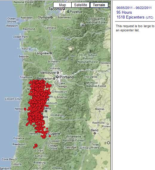
She also said that the recent activity in August in the MTJ area wasnt really an ETS.
Im going to study this ETS thing more. Its an obvious precursor, but what its saying I dont get. They arent following schedule these days it seems

She also said that the recent activity in August in the MTJ area wasnt really an ETS.
Im going to study this ETS thing more. Its an obvious precursor, but what its saying I dont get. They arent following schedule these days it seems
edit on 21-10-2011 by zworld because: (no reason given)
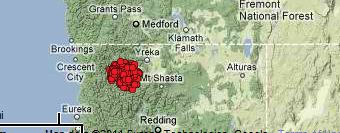
The latest ETS in the southern CSZ continues with another 357 today. The last ETS in this area was last half of Nov last year, so I guess this one is
right on schedule actually. Only the northern ETS was out of schedule.

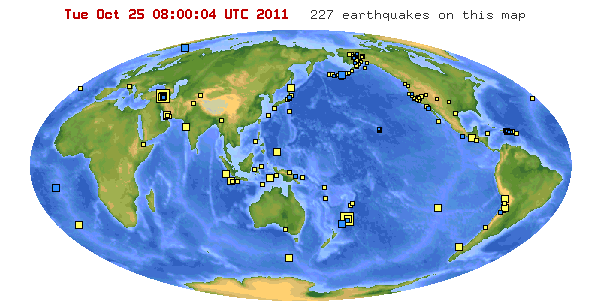
Some 7+ Earthquakes happening recently:earthquake.usgs.gov...

edit on 25-10-2011 by CaptainKostr because: (no reason given)
new topics
-
An Interesting Conversation with ChatGPT
Science & Technology: 3 hours ago
top topics
-
Have you noticed?? Post Election news coverage...
World War Three: 16 hours ago, 12 flags -
Squirrels becoming predators
Fragile Earth: 14 hours ago, 10 flags -
Drone Shooting Arrest - Walmart Involved
Mainstream News: 13 hours ago, 10 flags -
World's Best Christmas Lights!
General Chit Chat: 13 hours ago, 8 flags -
Can someone 'splain me like I'm 5. Blockchain?
Science & Technology: 14 hours ago, 7 flags -
Labour's Anti-Corruption Minister Named in Bangladesh Corruption Court Papers
Regional Politics: 15 hours ago, 6 flags -
An Interesting Conversation with ChatGPT
Science & Technology: 3 hours ago, 3 flags
active topics
-
World's Best Christmas Lights!
General Chit Chat • 12 • : GENERAL EYES -
An Interesting Conversation with ChatGPT
Science & Technology • 7 • : CosmicFocus -
The King James Bible, it's Translation, it's Preservation and its Inspiration
Religion, Faith, And Theology • 44 • : GENERAL EYES -
Drones everywhere in New Jersey ---and Elsewhere Master Thread
Aliens and UFOs • 201 • : worldstarcountry -
Drone Shooting Arrest - Walmart Involved
Mainstream News • 26 • : worldstarcountry -
Can someone 'splain me like I'm 5. Blockchain?
Science & Technology • 74 • : worldstarcountry -
Trump Meets Kristen Welker on Meet the Press
Mainstream News • 20 • : Astrocometus -
Smartest Man in the World Tells His Theory About What Happens At Death
Philosophy and Metaphysics • 44 • : AlroyFarms -
The Mystery Drones and Government Lies --- Master Thread
Political Conspiracies • 150 • : worldstarcountry -
A Bunch of Maybe Drones Just Flew Across Hillsborough County
Aircraft Projects • 84 • : worldstarcountry

