It looks like you're using an Ad Blocker.
Please white-list or disable AboveTopSecret.com in your ad-blocking tool.
Thank you.
Some features of ATS will be disabled while you continue to use an ad-blocker.
share:
Originally posted by CaptainKostr
snip
Earth Quake Predictions, Hell I want Earthquake Prevention! lol
snip
You're not the only one. Some folks have worked out a pretty smart protection scheme. While not prevention, it does offer a degree of protection.
Practically, band gaps properties of sonic crystal structures were used in application of reduction of vibrations or sound wave. In this study, we consider crystal structures for suspension of destructive seismic waves from an earthquake in a theoretical manner. Accordingly, we referred these crystals as Seismic Crystal and application of isolating a region from destructive seismic wave as Earthquake Shielding
It seems as though crystalline structure has what are termed "band gaps" which is a way of saying that certain portions of certain frequencies are not transmitted via that medium (crystal structure) resulting in a scattering or damping of the energy passing through the structure.
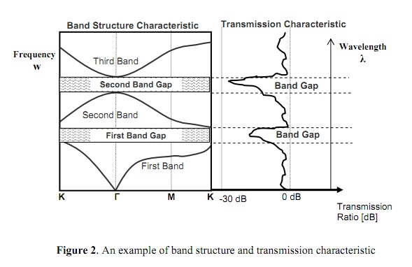
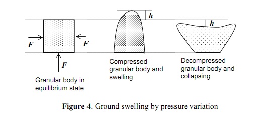
There is also the damping effect caused by compression/expansion of these Seismic Crystals as the P-waves pass through the crystals.
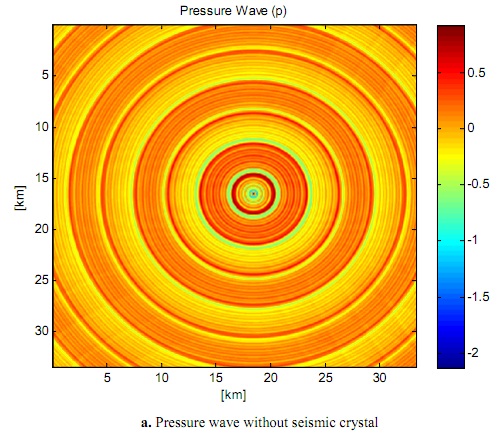
As an earthquake happens, the energy emanates outward from the epicenter in a radial pattern:
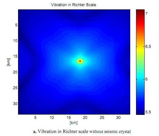
The greatest damage done, however is due to S-waves which come after the initial pressure wave.
Now, let's say you arrange a “seismic fence” around a city or region like this:
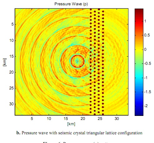
And you have a damping effect upon the initial p-waves. What about the shaking?
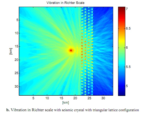
Looks like both types of waves are substantially lessened by passing through the “fence” in a way similar to a laser passing through a perforated screen. You can change the arrangement of the individual crystals and get different levels of protection:
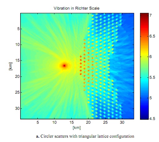
You can also change the shape of the crystals themselves to achieve an even greater variety of protection:
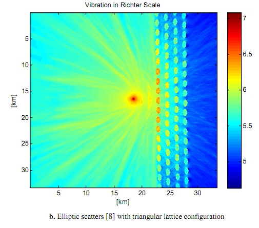
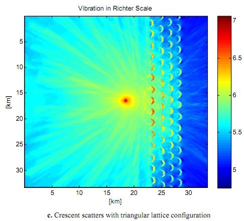
And then use those different shaped crystals in varying arrangements until you have the optimal protection available. All in all, a really neat idea whose time may need to wait for further advances in materials science.
Or not...
As we've seen with predictive seismology, the actual level of technological capability and what is admitted to or used in “public view” is not always the same.
The thing is, we just don't know how far along they are as they won't tell us, we've got to ferret it out for ourselves.
Magnitude
3.1
Date-Time
Saturday, October 08, 2011 at 18:55:21 UTC
Saturday, October 08, 2011 at 11:55:21 AM at epicenter
Location
35.492°N, 118.391°W
Depth
4 km (2.5 miles)
Region
CENTRAL CALIFORNIA
Distances
17 km (11 miles) SSE (157°) from town of Lake Isabella, CA
17 km (11 miles) SSW (197°) from Weldon, CA
27 km (17 miles) SW (216°) from Onyx, CA
60 km (37 miles) ENE (75°) from Bakersfield, CA
160 km (100 miles) N (355°) from Los Angeles Civic Center, CA
Location Uncertainty
horizontal +/- 0.3 km (0.2 miles); depth +/- 1 km (0.6 miles)
Parameters
Nph= 69, Dmin=20 km, Rmss=0.29 sec, Gp= 47°,
M-type=local magnitude (ML), Version=0
Source
California Integrated Seismic Net:
USGS Caltech CGS UCB UCSD UNR
Event ID
ci15060820
earthquake.usgs.gov...
Concerning the data referenced that discusses the depth of the asthenosphere in the SoCal/Mexico border area, this is the same condition that exists
in northwestern California mentioned previously. They are called slab gaps, slab windows, and slabless windows. All mean the same thing. The under
riding plate that is being subducted has a stretch where it literally tears apart and leaves an opening that is filled by magma from below. These
areas that are closest to the mantle often experience volcanic activity.
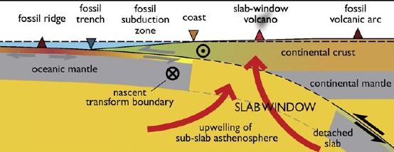
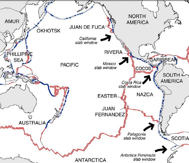
Im still trying to find it, but one study Im fairly certain found the depth in the NCal window to be the closest to the mantle anywhere but its been awhile and Ill keep looking.
ON EDIT: actually Im wrong. The area they are referring to is far north of the Mexico window. Maybe a newly discovered tear, but its not a triple junction area which means not likely.
edit on 8-10-2011 by zworld because: (no reason given)
I miss read the article about the research in the CA/Mexico border area. This appears to deal with just the thickness of the continental plate, not
two plates and a window. I assume the effects are the same, hot magma closer to the surface, but dont know. Its not an area with past volcanic
activity that I know of.
The depth to magma south of the Mendocino Triple Junction is closer to the surface I believe as well. I mentioned earlier that I thought that Mt. St. Helena was the other sister volcano that Cayce referred too, and this is why. The map below shows the general area considered to be slabless.
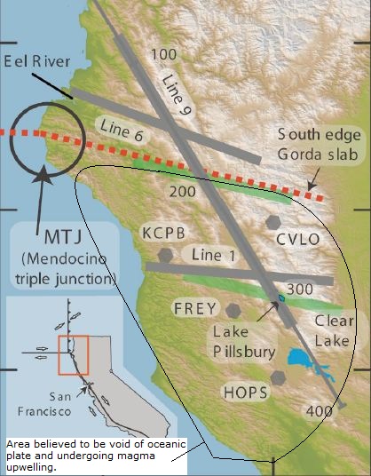
The Gorda Plate has fractured and is a piece of oceanic crust being pushed into extinction by the Pacific Plate to the south, North American Plate to the east/northeast and the JDF from the north. This is the reason that major EQs are more frequent in the southern most Cascadia. The return interval increases as one heads north, with the avg. being 230 years in the Gorda area up to 500+ years at the north end of the CSZ.
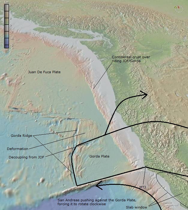
The slab window extends as far south as the Geysers at this time, and it is moving south/southeast. Immediately south/southeast of the Geysers is Mt. St. Helena. If you look at the figure in other post of a slab window, you will see that behind the slab window, in the area where the slab window once was, are archaic volcanos. For the Gorda window, these would be Mt Mazama, Mt Shasta and Mt Lassen.
Nothing is stopping the progression south of the volcano chain in the Pacific Northwest.
The depth to magma south of the Mendocino Triple Junction is closer to the surface I believe as well. I mentioned earlier that I thought that Mt. St. Helena was the other sister volcano that Cayce referred too, and this is why. The map below shows the general area considered to be slabless.

The Gorda Plate has fractured and is a piece of oceanic crust being pushed into extinction by the Pacific Plate to the south, North American Plate to the east/northeast and the JDF from the north. This is the reason that major EQs are more frequent in the southern most Cascadia. The return interval increases as one heads north, with the avg. being 230 years in the Gorda area up to 500+ years at the north end of the CSZ.

The slab window extends as far south as the Geysers at this time, and it is moving south/southeast. Immediately south/southeast of the Geysers is Mt. St. Helena. If you look at the figure in other post of a slab window, you will see that behind the slab window, in the area where the slab window once was, are archaic volcanos. For the Gorda window, these would be Mt Mazama, Mt Shasta and Mt Lassen.
Nothing is stopping the progression south of the volcano chain in the Pacific Northwest.
edit on 8-10-2011 by zworld because: (no reason
given)
In my post directly above, I forgot a paragraph that should be under the second figure (showing Gorda Plate rotation). Please insert.
In the figure above we see the Gorda Plate and it's relation to it's neighbors. It is a relatively thin plate surrounded by two giants. Because of the intense pressure exerted upon the Gorda plate, which is the tip of the Juan De Fuca plate, (the last remnant of the Farallon plate), it has fractured (deformation areas) and broken free (decoupled) from the JDF. As the Pacific plate moves north along the San Andreas, it hits the Gorda plate head on, forcing it to rotate clockwise into the N. American plate, creating intense pressure. South of the Gorda plate under the coast range is the slab window, where magma is closest to the surface anyplace on earth.
In the figure above we see the Gorda Plate and it's relation to it's neighbors. It is a relatively thin plate surrounded by two giants. Because of the intense pressure exerted upon the Gorda plate, which is the tip of the Juan De Fuca plate, (the last remnant of the Farallon plate), it has fractured (deformation areas) and broken free (decoupled) from the JDF. As the Pacific plate moves north along the San Andreas, it hits the Gorda plate head on, forcing it to rotate clockwise into the N. American plate, creating intense pressure. South of the Gorda plate under the coast range is the slab window, where magma is closest to the surface anyplace on earth.
edit on 9-10-2011 by zworld because: (no reason given)
The latest concerning the EQ swarm that has been on going in the Canary Islands.
ON EDIT:
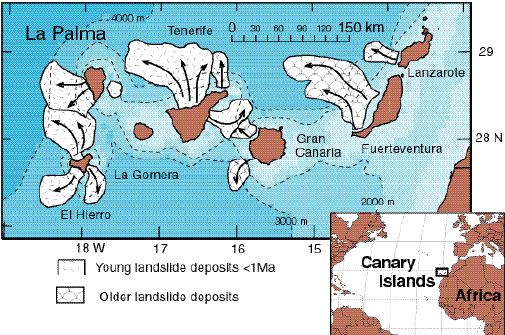
Map shows relation of El Hierro to La Palma, where a mega tsunami is feared to originate if the Cumbre Viejo volcano erupts.
www.rense.com...
wet.kuleuven.be...
MORE ON EDIT: It appears that the El Hierro island has also produced mega tsunamis in the distant past.
www.volcanolive.com...
Volcanic eruption alert on Spanish Canary Island
The regional government of the Spanish Canary Island of El Hierro has issued a volcanic eruption alert following almost 10,000 small tremors recorded in the past three months. The government posted a yellow alert — second level in a scale of four — Sunday and closed some hillside roads and a tunnel to avoid possible injury by falling rocks. The island's 11,000 residents have been told to monitor communications by the civil protection authority. The island was shaken late Saturday by a 4.3-magnitude quake. Seismic activity began in the area on July 17.
ON EDIT:
Map shows relation of El Hierro to La Palma, where a mega tsunami is feared to originate if the Cumbre Viejo volcano erupts.

www.rense.com...
Dr Simon Day, who works at the Benfield Greig Hazards Research Centre, University College London*, says that one flank of the Cumbre Vieja volcano on the island of La Palma, in the Canaries, is unstable and could plunge into the ocean during the volcano's next eruption.
Dr. Day says: "If the volcano collapsed in one block of almost 20 cubic kilometres of rock, weighing 500 billion tonnes - twice the size of the Isle of Wight - it would fall into water almost 4 miles deep and create an undersea wave 2000 feet tall. Within five minutes of the landslide, a dome of water about a mile high would form and then collapse, before the Mega Tsunami fanned out in every direction, travelling at speeds of up to 500 mph. A 330ft wave would strike the western Sahara in less than an hour."
wet.kuleuven.be...
Abstract. Geological evidence suggests that during a future eruption, Cumbre Vieja Volcano on the Island of La Palma may experience a catastrophic failure of its west flank, dropping 150 to 500 km3 of rock into the sea. Using a geologically reasonable estimate of landslide motion, we model tsunami waves produced by such a collapse. Waves generated by the run-out of a 500 km3 (150 km3) slide block at 100 m/s could transit the entire Atlantic Basin and arrive on the coasts of the Americas with 10-25 m (3-8 m) height.
MORE ON EDIT: It appears that the El Hierro island has also produced mega tsunamis in the distant past.
www.volcanolive.com...
2011 Unrest An earthquake swarm occurred at El Hierro volcano in July 2011 with 720 earthquakes measured in a week. The earthquakes were measured between magnitude 1-3, and most were at a depth of 5-15 km. The swarm occurred at El Golfo in the northwest of the island at the location of a landslide that created a 100 metre high tsunami about 50,000 years ago. The earthquakes were continuing at the end of September and some evacuations were ordered for people living near the volcano.
edit on 9-10-2011 by zworld because: (no reason given)
Magnitude
3.0
Date-Time
Sunday, October 09, 2011 at 11:47:00 UTC
Sunday, October 09, 2011 at 04:47:00 AM at epicenter
Time of Earthquake in other Time Zones
Location
33.708°N, 119.407°W
Depth
0.1 km (~0.1 mile) (poorly constrained)
Region
CHANNEL ISLANDS REGION, CALIFORNIA
Distances
53 km (33 miles) N (10°) from San Nicolas Is., CA
53 km (33 miles) SSW (199°) from Channel Islands Beach, CA
54 km (34 miles) SSW (201°) from Port Hueneme, CA
58 km (36 miles) SSW (201°) from Oxnard, CA
114 km (71 miles) WSW (250°) from Los Angeles Civic Center, CA
Location Uncertainty
horizontal +/- 0.6 km (0.4 miles); depth +/- 1.7 km (1.1 miles)
Parameters
Nph= 38, Dmin=38 km, Rmss=0.49 sec, Gp=104°,
M-type=local magnitude (ML), Version=1
Source
California Integrated Seismic Net:
USGS Caltech CGS UCB UCSD UNR
Event ID
ci15061092
earthquake.usgs.gov...
3.0 2011/10/09 04:47:00 33.708N 119.407W 0.1 53 KM (33 MI) N OF SAN NICOLAS IS., CA
3.1 2011/10/08 11:55:21 35.492N 118.391W 4.0 17 KM (11 MI) SSW OF WELDON, CA
4.0 2011/10/07 15:10:10 36.915N 117.514W 0.0 20 KM (13 MI) SW OF SCOTTYS CASTLE, CA
3.2 2011/10/05 00:36:19 33.479N 116.454W 14.7 22 KM (14 MI) ESE OF ANZA, CA
earthquake.usgs.gov...
reply to post by zworld
LOVE those images and information. That's the kind of stuff I love to look at and read about.
@Berkleygal: thanks for the quake info. I have noticed a bit of an uptick the last two days in the 2+ range. Have you personally heard/seen increased warnings or info on quake awareness? I know that it's typical to have it now due to the shakeout, but does it seem to be a lot more than usuall or normal?
reply to post by westcoast
There was something on the TV the other day about a news story on the local news that said Bay Area scientists were on the cutting edge of predicting earthquakes days in advance. well, I MISSED that story.
Other than that I have not noticed an uptick of "warnings" or "be prepared" announcements.
ETA
Here's a few good links for reading.
geology.com...
scrippsnews.ucsd.edu...
edit on 9-10-2011 by berkeleygal because: (no reason given)
I found one of the references concerning depth to magma in the Mendocino Co area. Its not the one Im looking for but its good. They state shallowest
in California and maybe N America, but Im pretty sure its the whole world.
www.johnmartin.com...
And I should add that its my own speculation concerning whether the window extends down to the Geysers and is moving south. It shouldn't be moving at all and is being filled in by the Gorda Plate, but when the Gorda PLate fractured and decoupled in one of the mega quakes, it started getting rotated as described above and is now pushing the window south, compressing the mantle upwelling into the N American Plate. And Geysers shows constant EQ activity at the depth that the magma would be interacting with the N American Plate.
ON EDIT: Another good quote. this one references both the Mendo hole and the one down south in Salton area that USGS is concerned about.
Lithospheric thickness along the San Andreas fault has been investigated by using delay times of teleseismic arrivals and thermal models (Zandt and Furlong, 1982). These studies indicate a lithospheric thickness of only 30 to 60 km for much of western California, and as little as 20 km for northern California just south of Cape Mendocino. These lithospheric thicknesses contrast with averages of 60 to 80 km for the Western United States and 120 to 170 km for the Central and Eastern United States (Iyer and Hitchcock, 1989)...... This geometry produces the thinnest lithosphere in California and, probably, in North America.
www.johnmartin.com...
And I should add that its my own speculation concerning whether the window extends down to the Geysers and is moving south. It shouldn't be moving at all and is being filled in by the Gorda Plate, but when the Gorda PLate fractured and decoupled in one of the mega quakes, it started getting rotated as described above and is now pushing the window south, compressing the mantle upwelling into the N American Plate. And Geysers shows constant EQ activity at the depth that the magma would be interacting with the N American Plate.
edit on 9-10-2011 by zworld because: (no reason
given)
edit on 9-10-2011 by zworld because: (no reason given)
ON EDIT: Another good quote. this one references both the Mendo hole and the one down south in Salton area that USGS is concerned about.
The crust along the San Andreas fault system thickens from about 16 km at Cape Mendocino, in northern California, to about 30 km in southern California and thus is significantly thinner than the average thickness (36 km) for the conterminous United States. Lithospheric thickness (20-60 km) is also substantially less along most of the San Andreas fault system than is typical for continental areas (60-170 km). The lithosphere is thinnest at both ends of the fault system, at the Mendocino triple junction on the north, where the North American plate is sliding off the edge of the Gorda plate as it moves northward, and in the Salton Trough on the south, where onshore spreading centers of the East Pacific Rise are generating new crust in a rift between the North American and Pacific plates. In contrast, the lithosphere is abnormally thick (250 km) in the Tranverse Ranges, where "subduction" of lithospheric mantle is occurring.
edit on 9-10-2011 by zworld because: (no reason given)
Its been some time now since we have
heard from Middlebrook. Perhaps the
last post was it before the date of the
prediction which is in about 3 weeks.
Not a good thought, but I have been
thinking about it a lot. Not trying to
fearmonger, seriously. Just not feeling
right about how things are going, there
were some small quakes around LA
county today.
Not So Cal but noteworthy nonetheless
earthquake.usgs.gov...
Magnitude
4.2
Date-Time
Monday, October 10, 2011 at 05:39:32 UTC
Sunday, October 09, 2011 at 10:39:32 PM at epicenter
Time of Earthquake in other Time Zones
Location
50.606°N, 129.663°W
Depth
30.8 km (19.1 miles)
Region
VANCOUVER ISLAND, CANADA REGION
Distances
158 km (98 miles) W of Port Hardy, British Columbia, Canada
201 km (124 miles) SSW of Bella Bella, British Columbia, Canada
492 km (305 miles) WNW of Vancouver, British Columbia, Canada
516 km (320 miles) WNW of VICTORIA, British Columbia, Canada
Location Uncertainty
horizontal +/- 28.5 km (17.7 miles); depth +/- 10.8 km (6.7 miles)
Parameters
NST=154, Nph=155, Dmin=552.1 km, Rmss=1.17 sec, Gp=173°,
M-type=body wave magnitude (Mb), Version=7
Source
Magnitude: USGS NEIC (WDCS-D)
Location: USGS NEIC (WDCS-D)
Event ID
usc00066t8
earthquake.usgs.gov...
Originally posted by jadedANDcynical
It seems as though crystalline structure has what are termed "band gaps" which is a way of saying that certain portions of certain frequencies are not transmitted via that medium (crystal structure) resulting in a scattering or damping of the energy passing through the structure.
Fascinating J&C. I hope I can understand all the ramifications and put to use. In the Fuku thread we talked about how crystalline lattice structures can store energy transmitted by a radioactive particle that hits it and dislodges one of the atoms in the lattice. This energy is very powerful, and the crystal particle holds on to it. Wigner Effect its called. Blown up nuke labs before it has.
I wonder if the crystals are holding on to the P and S wave energy. Or if the waves hitting the crystals do something like the Wigner Effect.
Thanks for the new avenue of thought.
I know this is a little North of the Salton Sea........but get a load of these potential harmonic tremors the last couple days, just south and east of
Fresno, Ca.
Can someone pipe in and calm me jitters a little?
earthquake.usgs.gov...:
Can someone pipe in and calm me jitters a little?
earthquake.usgs.gov...:
edit on 11-10-2011 by radpetey because: (no reason
given)
edit on 11-10-2011 by radpetey because: massive issues
edit on 11-10-2011 by radpetey because: (no reason
given)
reply to post by radpetey
What makes you think those are HT? I admit it's messy, but could be weather, etc. Harmonic tremors that I have seen appeared very differently. It would certainly be worth trying to track down a more reliable seismo though and giving it a closer look. Good find.
I noticed it is a bit more active with several +3 mag quakest this morning in Souther Cal/N Mexico:
quake list
Just saw this....does anyone have info on it? I'm trying to find out more....This was in an introduction thread, which the OP must have not realized
they need 20 posts first, so it may disappear.....which is why I brought it here. www.abovetopsecret.com...
Here's the news article the op referred to, though it didn't have much info.
www.fox43.com...
Here's the news article the op referred to, though it didn't have much info.
www.fox43.com...
reply to post by radpetey
Very unlikely to be HT, I think. Just doesn't look like it. We see a lot of this on some of the Yellowstone webis and they are not HT. They are just the effects of wind, or sometimes tree roots as nearby trees are moved by wind. I suspect if will be the same case here.
To back up this premise, if we look at the location of the seismograph, it's at 36.2863 -119.0871, and a check on Google Earth shows it's a fairly open, exposed area with a few trees around. Altitude around 470 metres. (Roughly 1500 feet.) So, fair chance it catches a bit of wind.
For a list of seismos and their locations, just go to this page on NCEDC.org. Scrolling down about 3/4 of the way, you find this line:
The lat. and long. coordinates are shown just after the ID code for the seismo.
EDIT: forgot to note that NCEDC stands for the Northern California Earthquake Data Center. Here is the NDEDC HOME PAGE
Best regards,
Mike
Very unlikely to be HT, I think. Just doesn't look like it. We see a lot of this on some of the Yellowstone webis and they are not HT. They are just the effects of wind, or sometimes tree roots as nearby trees are moved by wind. I suspect if will be the same case here.
To back up this premise, if we look at the location of the seismograph, it's at 36.2863 -119.0871, and a check on Google Earth shows it's a fairly open, exposed area with a few trees around. Altitude around 470 metres. (Roughly 1500 feet.) So, fair chance it catches a bit of wind.
For a list of seismos and their locations, just go to this page on NCEDC.org. Scrolling down about 3/4 of the way, you find this line:
MRH NC 36.2863 -119.0871 432 "EHE EHN EHZ ELE ELN ELZ SHZ SLE SLN SLZ " "Rocky Hill" 1993,126,21:30:00 2500,365,23:59:59.9999
The lat. and long. coordinates are shown just after the ID code for the seismo.
EDIT: forgot to note that NCEDC stands for the Northern California Earthquake Data Center. Here is the NDEDC HOME PAGE
Best regards,
Mike
edit on 11/10/11 by JustMike because: of (a ) a tense correction. We not only used to see the same thing at Yellowstone, we still do! And
(b ) to add the note about the NCEDC.
I was not sure at all about the h.t., I was simply passing it on for more educated analysis.
However, I have enclosed that station for the last couple of days, and it has a few rather interesting signatures.
Tell me what y'all think.
However, I have enclosed that station for the last couple of days, and it has a few rather interesting signatures.
Tell me what y'all think.
reply to post by StealthyKat
I do hope they look into fracking
in Pennsylvania, may or may not
be what is causing the tremors.
I hope what happened in Arkansas
has been a lesson to those areas
experiencing similar activity.
I do hope they look into fracking
in Pennsylvania, may or may not
be what is causing the tremors.
I hope what happened in Arkansas
has been a lesson to those areas
experiencing similar activity.
new topics
-
An Interesting Conversation with ChatGPT
Science & Technology: 7 hours ago
top topics
-
World's Best Christmas Lights!
General Chit Chat: 17 hours ago, 8 flags -
An Interesting Conversation with ChatGPT
Science & Technology: 7 hours ago, 7 flags
active topics
-
Drone Shooting Arrest - Walmart Involved
Mainstream News • 30 • : BeyondKnowledge3 -
An Interesting Conversation with ChatGPT
Science & Technology • 15 • : BeyondKnowledge3 -
The Truth Behind the Manchester Airport "Police Assault" Video
Social Issues and Civil Unrest • 44 • : Freeborn -
Was Biden's Mass clemency and pardons one last cash grab?
US Political Madness • 17 • : gortex -
Post A Funny (T&C Friendly) Pic Part IV: The LOL awakens!
General Chit Chat • 7930 • : baddmove -
Drones everywhere in New Jersey ---and Elsewhere Master Thread
Aliens and UFOs • 203 • : xuenchen -
Squirrels becoming predators
Fragile Earth • 27 • : PorkChop96 -
US Federal Funding set to Expire December 20th. Massive CR on the way.
Mainstream News • 32 • : LSU2018 -
Can someone 'splain me like I'm 5. Blockchain?
Science & Technology • 76 • : Flyingclaydisk -
Russias War Against Religion in Ukraine
World War Three • 48 • : andy06shake
