It looks like you're using an Ad Blocker.
Please white-list or disable AboveTopSecret.com in your ad-blocking tool.
Thank you.
Some features of ATS will be disabled while you continue to use an ad-blocker.

WTC7 Faked Image
page: 7share:
Originally posted by Caustic Logic
As far as I can see the NIST has not cited the vertical extent of this gouge, but cites the collapse as beginning with the columns damaged at the lower floors (below 13), so it seems to have run clean to the ground. Sliiiiice. I don't believe it was evacuated at the time.
Do people know about this?
The gash appears to run to at least the 7th floor, assuming the red line marks the edge of the gash in this image.

And assuming that this analysis by 'Winston Smith' of the Study of 911 of the floors and columns is accurate.

I think this looks more like another shot of the corner damage. Wouldn't the center gouge be further to the right? Did you see that ground level
shot?
Originally posted by Caustic LogicI may have found another shot of the gouge: Where's that jagged yellow glow between the bridgae and promenade coming from?
I think you might be looking the wrong way here. I think the view is from the WTC7 side of Vessey St (red circle in the image below) looking back south between WTC5 and WTC6, which is damaged and aglow.

Originally posted by Caustic Logic
I think this looks more like another shot of the corner damage. Wouldn't the center gouge be further to the right?
If you count in from the west edge of WTC7 in the ABC 'gash' shot, it appears at around column 5. The low shot I posted also appears to have a very straight edge to the trauma at around column 5, which is why I wondered whether it was an extension of the gash.
Even if they're not one and the same, I don't think the gash, would be much further to the east.
Hmmm... I think I got turned around on Vessey, but it's an interesting picture anyway. Odd tho in a report about WTC7 they should show a view away
from the building.
I still dunno about that other pic - I think it's good verification that there was the corner damage, possibly the best shot I've seen yet, showing its extent on the south face, but I'm not spot-on tonight. .
Still very little verification of that central damage that some would say could've caused a global collapse. Rather odd.
I assume people are reasonably comfortable with the estimates I gave earlier for the time the photgraphs in the OP were taken (repeated here
for those who missed it).

If so, I think we're looking for an 'event' between 2:00 (the time of the 'undamaged' photo) and 2:30pm (the time of the 'damaged' one) that caused the damage.
This video includes a possible candidate 'event'. Can anyone locate the payphone here so we can try and determine what time this footage was shot?
I'm looking at the original pics again and my trigonometry isn't working great right now, but I'm comfortable with the basic idea that they were
near in time and in the afternoon.
Thanks for the Winston smith link BTW: Already I find an interesting passage accompanying that analysis:
Or the other gouge we're looking at but higher up? I think it can be seen beginning (no wall between windows) at about the 12th floor in the blur line zone?
Thanks for the Winston smith link BTW: Already I find an interesting passage accompanying that analysis:
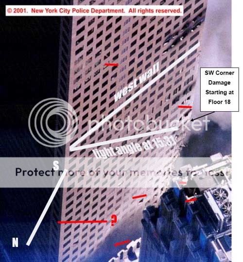
At it's widest point, the damage can be seen to extend from column 5 to column 1 (the south west edge of the structure), and is in the same location as the south west corner damage shown in Fig. 2. Captain Chris Boyle's description of a 20-storey hole in the middle of the south face is refuted by this photo, which shows a quite intact facade in that region. The fact that Boyle's testimony described a 20 storey hole, and the damage to the south west corner reached approximately to the 20th floor, would suggest that Boyle either visually interpreted the location of the hole incorrectly at the time, or his later recollection from memory was incorrect, and what he saw was in fact the hole we see in this photo.
Or the other gouge we're looking at but higher up? I think it can be seen beginning (no wall between windows) at about the 12th floor in the blur line zone?
Screen shot: camera panning from phone to suspected source of explosion
NY layout Detectived fire away, and shadow analysis from there and we can get a pretty good time for this loud ass boom...
One thing I hadn't taken into account is that the data I used for the sun's altitude and azimuth was quoted in EST whereas I believe it was EDT on
Septemebr 11th. That pushes the times back an hour, so the window is now between around 3:00pm and 3:30pm.

All that work and those times are still an hour off. There is something weird about this thread. I am behind on the WTC stories, and so all this seems
new and exciting to me. Yet no new comments. Are there that many WTC7 threads where this is covered? I'll have to scan back and see where this was
all covered and resolved already...
Oh and yeh I had that Vessey street shot turned around.
Oh and yeh I had that Vessey street shot turned around.
Originally posted by Caustic LogicAll that work and those times are still an hour off.
Are you reasonably satisfied that we're looking for an event between approxinately 3 and 3:30pm or do you think the times might be out?
I have triple-checked this throughout the day and found one small, inconsequential error - nothing that has an impact on my estimated window.
Originally posted by bsbray11
That's why we established relative times. Shadows indicate that the Sun was farther West when the second image, showing less damage, was taken. This was also pointed out on the first page of the thread.
I'm a little confused how the shadows show what time it is. Can you explain this in more detail?
I have another pic that I'm pretty sure is faked and the shadow analysis is very important.
Oops I seemed rude there. It was just the irony of it, been there myself but great work. Numbers updated, small problem fixed, I thought it looked
about right before. Now, well it's a bit complex. Here I took the angle of the edge of WTC7, north/south axis, and sun angle at 15:31 and
superimposed it over the NIST shot. Then I realized yours are drawn on from directly above, this is at an anlge.
Buuut...
here's what I see for shadow line correspondence not accounting for that:
If I'm visualizing it right, the difference makes it closer to your time angle of 15:30. Right in there I'd say. And this is why sun dials worked fine until the invention of the clock. Great work Coughymachine! You're at about WATS territory now but that button has gone bye bye.
Thanks CL- good to have the times corroborated (your compass arrow looks spot on to me). Now we've just got to figure out what happened between
3:00pm and 3:30pm to cause that gouge.
In the light of the reports by firefighters that the building was bulging and "moving" from quite early on it is always possible that there was no
particular event, but rather that the bottom part of the corner collapsed of its own accord as a result of the damage caused earlier in the day.
Interestingly, this may fit in with the rather odd comment made by Giuliani on TV that the building collapsed in stages over a period of time which were posted here a couple of weeks ago and caused a lot of confusion at the time.
www.abovetopsecret.com...
Interestingly, this may fit in with the rather odd comment made by Giuliani on TV that the building collapsed in stages over a period of time which were posted here a couple of weeks ago and caused a lot of confusion at the time.
www.abovetopsecret.com...
Originally posted by nick7261
Originally posted by bsbray11
That's why we established relative times. Shadows indicate that the Sun was farther West when the second image, showing less damage, was taken. This was also pointed out on the first page of the thread.
I'm a little confused how the shadows show what time it is. Can you explain this in more detail?
I have another pic that I'm pretty sure is faked and the shadow analysis is very important.
Rises in the east, sets in the west, above at noon, somewhat from the south in the northern hemisphere, etc. It rises and sets at a certain predictable time on September 11 every year, and every other position of the sun has just as exact a time correlation and a matching light angle. With precise calculations CM has linked to earlier, exact angles can be deduced and given an exact time. I'm taking his word on that, I can tell it's mid-PM cause the west wall is lit up, but the sun still seems to be coming from closer to above than to hard west.
Hope that helps.
Originally posted by nick7261 Can you explain this in more detail?
I have another pic that I'm pretty sure is faked and the shadow analysis is very important.
This was the first one I've done, so I'm certainly no expert but this is what I did, if it's any help.
I got data pertaining to the sun's position on 9/11 from here. If your picture is also from 9/11, then you can use the figures I already have.
Astronomical Applications Dept.
U.S. Naval Observatory
Washington, DC 20392-5420
MANHATTAN, NEW YORK
o , o ,
W 73 58, N40 45
Altitude and Azimuth of the Sun
Sep 11, 2001
Eastern Standard Time
Altitude Azimuth
(E of N)
h m o o
04:40 -10.6 74.6
04:50 -8.8 76.3
05:00 -6.9 78.0
05:10 -5.1 79.7
05:20 -3.2 81.3
05:30 -1.3 83.0
05:40 1.0 84.6
05:50 2.7 86.2
06:00 4.5 87.9
06:10 6.3 89.5
06:20 8.2 91.1
06:30 10.1 92.8
06:40 12.0 94.4
06:50 13.8 96.1
07:00 15.7 97.8
07:10 17.6 99.5
07:20 19.4 101.3
07:30 21.3 103.0
07:40 23.1 104.9
07:50 24.9 106.7
08:00 26.7 108.6
08:10 28.5 110.6
08:20 30.3 112.6
08:30 32.0 114.7
08:40 33.7 116.9
08:50 35.4 119.1
09:00 37.0 121.5
09:10 38.6 123.9
09:20 40.1 126.4
09:30 41.6 129.1
09:40 43.1 131.8
09:50 44.4 134.7
10:00 45.7 137.7
10:10 47.0 140.8
10:20 48.1 144.1
10:30 49.2 147.5
10:40 50.2 151.1
10:50 51.0 154.8
11:00 51.8 158.6
11:10 52.4 162.5
11:20 52.9 166.5
11:30 53.3 170.6
11:40 53.5 174.8
11:50 53.6 179.0
12:00 53.6 183.2
12:10 53.4 187.4
12:20 53.1 191.5
12:30 52.6 195.6
12:40 52.1 199.5
12:50 51.4 203.4
13:00 50.5 207.1
13:10 49.6 210.8
13:20 48.6 214.2
13:30 47.5 217.6
13:40 46.3 220.8
13:50 45.0 223.8
14:00 43.7 226.8
14:10 42.3 229.6
14:20 40.8 232.3
14:30 39.3 234.8
14:40 37.7 237.3
14:50 36.1 239.7
15:00 34.4 242.0
15:10 32.7 244.2
15:20 31.0 246.3
15:30 29.3 248.3
15:40 27.5 250.3
15:50 25.7 252.3
16:00 23.9 254.1
16:10 22.1 256.0
16:20 20.2 257.8
16:30 18.4 259.5
16:40 16.5 261.3
16:50 14.6 263.0
17:00 12.7 264.7
17:10 10.9 266.3
17:20 9.0 268.0
17:30 7.1 269.6
17:40 5.3 271.2
17:50 3.4 272.9
18:00 1.7 274.5
18:10 0.0 276.1
18:20 -2.5 277.7
18:30 -4.3 279.4
18:40 -6.2 281.1
18:50 -8.1 282.7
19:00 -9.9 284.4
19:10 -11.7 286.2
Then try to get an aerial view of the locale and establish the compass points. Failing that, establish them as best you can with the shot you have. Then plot the shadows against the data table above.
Here is the final analysis for the two photographs in the OP.

The red lines indicate North-South. To calculate the times of the lines, take the blue line labelled "14:10" as an example. This is 211 degrees from North. Cross-reference that with the data table and we get 13:10. But that data is EST and New York was EDT on the day, so we add an hour.
ETA: I should have mentioned to ignore the shadows in the aerial shot; I was working to the shadows in the two OP photographs.
ETA2: Out of interest, have a go at working out the time the aerial shot was taken. I get around 09:35.
ETA 3: Forgot to adjust for EDT. Revised estimate to 10:35.
[edit on 14-5-2007 by coughymachine]
[edit on 14-5-2007 by coughymachine]
[edit on 14-5-2007 by coughymachine]
coughymachine,
What about the angles on the Penthouse here?:
I crudely traced the angle of the shadow West of the Penthouse here:
It's steeper than either of your others, yet this is supposed to be from the same helicopter pass (maybe it wasn't after all?).
I used it earlier rather than the one below, because it's MUCH easier to make out angles, if it's from the same time.
You'd have to use the top of the Verizon Building, where nothing was obstructing light, for the most accurate view, but unfortunately the top of the building isn't flat and there's hardly anything to get a good angle from without a drop in altitude on top of the building or etc.
Your analysis may not be that off, but it'd be nice if we can find something clearer, you know?
[edit on 14-5-2007 by bsbray11]
What about the angles on the Penthouse here?:

I crudely traced the angle of the shadow West of the Penthouse here:

It's steeper than either of your others, yet this is supposed to be from the same helicopter pass (maybe it wasn't after all?).
I used it earlier rather than the one below, because it's MUCH easier to make out angles, if it's from the same time.

You'd have to use the top of the Verizon Building, where nothing was obstructing light, for the most accurate view, but unfortunately the top of the building isn't flat and there's hardly anything to get a good angle from without a drop in altitude on top of the building or etc.
Your analysis may not be that off, but it'd be nice if we can find something clearer, you know?
[edit on 14-5-2007 by bsbray11]
Originally posted by bsbray11What about the angles on the Penthouse here?:
Well, this picture was taken before 13:21, since the west side is in shadow. I'll have a crack at a time if you want. What are you looking for?
new topics
-
Turns out, they planned to go after P-nut.
US Political Madness: 2 hours ago -
Sick sick sick
Social Issues and Civil Unrest: 9 hours ago -
Comcast dumping MSNBC
Mainstream News: 11 hours ago
top topics
-
Comcast dumping MSNBC
Mainstream News: 11 hours ago, 19 flags -
President-elect TRUMP Picks MATT GAETZ for his ATTORNEY GENERAL - High Level PANIC Ensues.
2024 Elections: 15 hours ago, 17 flags -
Turns out, they planned to go after P-nut.
US Political Madness: 2 hours ago, 9 flags -
Sick sick sick
Social Issues and Civil Unrest: 9 hours ago, 7 flags
active topics
-
Breaking: FBI Agents Raid Polymarket CEO After Betting Site Predicts Trump Win
General Conspiracies • 21 • : GlitchMechanic -
President-Elect DONALD TRUMP's 2nd-Term Administration Takes Shape.
Political Ideology • 170 • : Dandandat3 -
Critical shortcomings of the Patriot complex
Weaponry • 96 • : coldisbest118 -
How can you defend yourself when the police will not tell you what you did?
Posse Comitatus • 76 • : Oldcarpy2 -
WATCH LIVE: US Congress hearing on UFOs, unidentified anomalous phenomena
Aliens and UFOs • 42 • : putnam6 -
Turns out, they planned to go after P-nut.
US Political Madness • 12 • : PorkChop96 -
Sick sick sick
Social Issues and Civil Unrest • 42 • : Oldcarpy2 -
Comcast dumping MSNBC
Mainstream News • 17 • : WeMustCare -
The Acronym Game .. Pt.4
General Chit Chat • 948 • : Encia22 -
President-elect TRUMP Picks MATT GAETZ for his ATTORNEY GENERAL - High Level PANIC Ensues.
2024 Elections • 53 • : WeMustCare