It looks like you're using an Ad Blocker.
Please white-list or disable AboveTopSecret.com in your ad-blocking tool.
Thank you.
Some features of ATS will be disabled while you continue to use an ad-blocker.

Atlantis has been discovered?!
page: 36share:
originally posted by: All Seeing Eye
I've studied fringe for exactly that reason looking for tidbits that might be added to what we know. I have to say its been very very thin. However in the early day I did find a few interest concepts and ideas that I moved up the chain.
Do you know what happens to fringe that is actually real? It becomes mainstream and occasionally something that is mainstream is found to incorrect and it falls into the fringe.
One takes fringe on a case by case basis. Your current boondoggle is more fantasy than fringe driven as it is built on paranoia and 'filling in the gaps with make believe' along with a determined effort to avoid any contra-indicating evidence.
Good luck you can keep your current fantasy going for decades as the political and security conditions in that part of the world aren't going to get better for quite some time. Which means no large scale archaeological investigations.
One of the key aspects of bad fringe is to put the idea under question somewhere where it cannot be investigated or looked at properly (like a civilization under the Antarctic). Or simply ignore all evidence you don't like.
Keep going with blurry photos they're hilarious.
Look it's a rock structure - must be Atlantis.....
originally posted by: Hanslune
originally posted by: fromunclexcommunicate
a reply to: All Seeing Eye
The eye of the Sahara certainly might have looked like the eye of Horus during the AHP when there was more vegetation in the flooded valleys of those circles. Apparently just hunter gatherer types there that couldn't see it.
Given the size of it I don't anyone would have been able to determine what it looked like until flight and especially space flight.
Exactly - we never knew it existed until we started using satellites to map the planet. On the ground you'd walk across it without even being aware it existed. And even from an aircraft you wouldn't really notice it.
originally posted by: AndyMayhew
originally posted by: Hanslune
originally posted by: fromunclexcommunicate
a reply to: All Seeing Eye
The eye of the Sahara certainly might have looked like the eye of Horus during the AHP when there was more vegetation in the flooded valleys of those circles. Apparently just hunter gatherer types there that couldn't see it.
Given the size of it I don't anyone would have been able to determine what it looked like until flight and especially space flight.
Exactly - we never knew it existed until we started using satellites to map the planet. On the ground you'd walk across it without even being aware it existed. And even from an aircraft you wouldn't really notice it.
Aerial Archaeology involves interpretation and image analysis of photographic (and other kinds of images), in field research to understand archaeological features, sites, and landscapes. It enables exploration and examination of context and large land areas, on a scale unparalleled by other archaeological methods. The AARG (Aerial Archaeology Research Group) boasts that 'more archaeological features have been found worldwide through aerial photography than by any other means of survey'.[1]
Paul Kosok, an American historian from Long Island University in New York, is credited as the first scholar to study the Nazca Lines in depth. While in Peru in 1940–41 to study ancient irrigation systems, he flew over the lines and realized that one was in the shape of a bird.
Nazca Lines
Seen from the air, the dry summer reveals an ancient harvest of archaeological finds
Ahh, but there should be exceptions applied to the Richat. and why is that? Because the CIA still holds classified information concerning it. And believe it or not, I understand why.
CIA-RDP79BO1709AOQW00030003-2 Proposed Survey: Bosuntwi Crater, Flight Altitude 3,000 ft. Attachment (2) to Encl (1) of Approved For Release 2005/06/01 : CIA-RDP79B017&JA96 WOGOD3.r.4222 of MAR 3 16 Approved For PCIPase 2005/06/01 CIA-RDP79B01709 0.50 ro x outcrop .1:11n.i A- i!e'1 Proposed Survey: Richat Structure, Flight Altitude 3,000 ft. Approved For Release 2005/06/01
Yes, new discoveries are made by the mavericks that risk all and stick with what they know to be the truth. Whether on the ground, or in the air.
edit on AMTuesdayTuesday stAmerica/ChicagoAmerica/Chicago36510 by All Seeing Eye because: (no reason given)
originally posted by: All Seeing Eye
Aerial Archaeology involves interpretation and image analysis of photographic (and other kinds of images), in field research to understand archaeological features, sites, and landscapes. It enables exploration and examination of context and large land areas, on a scale unparalleled by other archaeological methods. The AARG (Aerial Archaeology Research Group) boasts that 'more archaeological features have been found worldwide through aerial photography than by any other means of survey'.[1]
Yes and before they announce it they do an on the ground verification - what is their opinion on the Richat?
Ahh, but there should be exceptions applied to the Richat. and why is that? Because the CIA still holds classified information concerning it. And believe it or not, I understand why.
Show that they do so and that you 'understand'? Yeah there were hostile groups then and now in that area but then you don't want to take that into consideration - the CIA could care less about Atlantis
CIA-RDP79BO1709AOQW00030003-2 Proposed Survey: Bosuntwi Crater, Flight Altitude 3,000 ft. Attachment (2) to Encl (1) of Approved For Release 2005/06/01 : CIA-RDP79B017&JA96 WOGOD3.r.4222 of MAR 3 16 Approved For PCIPase 2005/06/01 CIA-RDP79B01709 0.50 ro x outcrop .1:11n.i A- i!e'1 Proposed Survey: Richat Structure, Flight Altitude 3,000 ft. Approved For Release 2005/06/01
"Proposed Survey:" yep looking for bad guy bases - probably not to worried about Atlantis because the last time anyone wrote about it was sunk in the Atlantic ocean 11000 years ago. Why not see what else they were doing on aerial surveys of in Mauritania? Why do only cherry picking research?
Yes, new discoveries are made by the mavericks that risk all and stick with what they know to be the truth. Whether on the ground, or in the air.
....and which they verify with on the ground with a survey and test pits before making anything public since you cannot tell from images how old something is.....
edit on 31/5/22 by Hanslune because: (no reason given)
originally posted by: fromunclexcommunicate
a reply to: All Seeing Eye
3 water related features that would logically place the date to pre 3500bc.
Except Harte has quoted Plato concerning the size of Atlantis and it was described as more on the scale of ancient Athens itself than the Richat structure. There are other better candidates that might have inspired Plato. Porlock UK actually has submerged forests. The area was several miles inland until the sea level in the Bristol Channel rose about 7000 to 8000 years ago.
Now that's interesting. Also the British Isles could be seen as the "way to other isles". It matches a lot more criteria than the Eye.
originally posted by: Hanslune
originally posted by: fromunclexcommunicate
a reply to: All Seeing Eye
The eye of the Sahara certainly might have looked like the eye of Horus during the AHP when there was more vegetation in the flooded valleys of those circles. Apparently just hunter gatherer types there that couldn't see it.
Given the size of it I don't anyone would have been able to determine what it looked like until flight and especially space flight.
If the rings were full of water, then people would realize they were rings by mapping out the water way.
But also, if they were ever full of water, there are probably some signs we could look for. Depends on if it was a stagnate lake, like the Salt Lake in Utah, or a fresh water lake, with water flowing both into it, and out.
originally posted by: bloodymarvelous
originally posted by: fromunclexcommunicate
a reply to: All Seeing Eye
3 water related features that would logically place the date to pre 3500bc.
Except Harte has quoted Plato concerning the size of Atlantis and it was described as more on the scale of ancient Athens itself than the Richat structure. There are other better candidates that might have inspired Plato. Porlock UK actually has submerged forests. The area was several miles inland until the sea level in the Bristol Channel rose about 7000 to 8000 years ago.
Now that's interesting. Also the British Isles could be seen as the "way to other isles". It matches a lot more criteria than the Eye.
originally posted by: Hanslune
originally posted by: fromunclexcommunicate
a reply to: All Seeing Eye
The eye of the Sahara certainly might have looked like the eye of Horus during the AHP when there was more vegetation in the flooded valleys of those circles. Apparently just hunter gatherer types there that couldn't see it.
Given the size of it I don't anyone would have been able to determine what it looked like until flight and especially space flight.
If the rings were full of water, then people would realize they were rings by mapping out the water way.
But also, if they were ever full of water, there are probably some signs we could look for. Depends on if it was a stagnate lake, like the Salt Lake in Utah, or a fresh water lake, with water flowing both into it, and out.
At one point they may have been (full of water) but we don't know if the rings are 'water proof' whether there are springs or it all would come from rain run off. Might be in the geological studies. The problem of course when they were 'wet' would anyone remember that for thousands of years for when Plato was about? The Sahara was well into being a desert area when he was alive. Given all the lakes that dried up during that time I don't see why any one in particular would be remembered.
Too bad unlike every other civilization that 'Atlantis' had no pottery, stone tools or trade goods, because those we find spread far a and wide.
Well off for many weeks of vacation watching a relatives house in SF unfortunately they are electronic Luddites and have no internet and I hate trying to type using a phone. So, BM be careful the CIA doesn't snatch you up for looking for Atlantis and I'll be back.
a reply to: bloodymarvelous
Many of the papers I'm reading about the African Humid Period are starting to revise the amount of water that was present. They may want to consider a name change "African Wet Period". 12,000 - 3500 bc. All of them agree, the end came very rapidly, almost, overnight.
At the Eastern end of the Mountain range north of the rings is a channel that heads east. This channel is barely visible and filled with sand in places. "If" this channel connected up with the Maghreb, fresh water, inland, presently extinct sea, then it would have supplied water to the north and south of the mountain range, supplying fresh water in abundance, to the Rings.
The presence of salt in the area, I suspect, are the results of the destruction, and not normal.
But also, if they were ever full of water, there are probably some signs we could look for. Depends on if it was a stagnate lake, like the Salt Lake in Utah, or a fresh water lake, with water flowing both into it, and out.
Many of the papers I'm reading about the African Humid Period are starting to revise the amount of water that was present. They may want to consider a name change "African Wet Period". 12,000 - 3500 bc. All of them agree, the end came very rapidly, almost, overnight.
At the Eastern end of the Mountain range north of the rings is a channel that heads east. This channel is barely visible and filled with sand in places. "If" this channel connected up with the Maghreb, fresh water, inland, presently extinct sea, then it would have supplied water to the north and south of the mountain range, supplying fresh water in abundance, to the Rings.
The presence of salt in the area, I suspect, are the results of the destruction, and not normal.
a reply to: Hanslune
Invest in a laptop. Does your phone have a hot spot? I would hate to think of loosing you for a whole week lol.
Be safe.
P.S. If you plan on going downtown, wear boots, I hear it can get pretty crappy around there lol
Well off for many weeks of vacation watching a relatives house in SF unfortunately they are electronic Luddites and have no internet and I hate trying to type using a phone. So, BM be careful the CIA doesn't snatch you up for looking for Atlantis and I'll be back.
Invest in a laptop. Does your phone have a hot spot? I would hate to think of loosing you for a whole week lol.
Be safe.
P.S. If you plan on going downtown, wear boots, I hear it can get pretty crappy around there lol
There is precedent for myths about water to become exaggerated. Especially if it explains something that is gnawing on the minds of those who
turn to the myth.
Specifically : Noah's Flood. Various versions exist, and are probably not accurate. There was probably a serious flooding event at the time of the Younger Dryas, but I highly doubt water levels would rise all the way to the mountain tops.
Nonetheless, people sometimes find sea shells on mountain tops. (Due to plate tectonics and stuff, having placed whole shelves under water in pre dinosaur times.) This reality probably bothered them a lot, and so they modified the legends to allow an explanation they could feel satisfied with.
Noah's flood may not have actually happened the way the story tells it, but it is a real myth. It can be proven that the story was told by various cultures over a long period of time.
My point is: Mauritania's Atlantis could suffer from an identical embellishment. Especially because the Sahara was under the ocean in Dinosaur scale time frames, and consequently has seashells.
a reply to: bloodymarvelous
I believe both events happened, the "sinking of the Ringed City", and the Great Flood. But not exactly like mike27 portrays. But both events as depicted in the ancient records are the result of the actions of the Ancient gods and are admitted to, by them.
If this were a crime investigation we have a situation where the criminals admits to what they have done, but the investigators constantly and continuously look to solve the crime by other means, by other "Natural" means. Oh they say, but these gods are nothing but myth, fantasy. They say they are not real therefore they could not be responsible. And at the very same time, these expert investigators look at ufo's and proclaim, "gee, it beats me what they are". Yes, they admit they are real now, but haven't a clue as to who they are. Pre flood, EVERYONE, knew who they were!
Noah's flood was accomplished for the very same reason the Ringed City was destroyed. In fact if the ancient records are correct, the flood and the destruction of the Ringed City were only separated by 2 years.
Yes, it actually happened! But not for the stated reasons. Mankind was becoming Noisy? We were full of sin? In who's eyes? In truth, the sin to the gods was that mankind, was becoming like the gods, becoming knowledgeable of the secrets of the gods, technology. That was the true sin. And the real reason mankind was to be set back, re started. They wanted us as originally designed, ignorant and obedient. And today, I can only see how proud the gods are for what they have accomplished with our ignorant superstitious humanity.
There is ample evidence from palaeobotanic and palaeoclimatic reconstructions that during early and mid-Holocene between some 11,700 years (in some regions, a few thousand years earlier) and some 4200 years ago, subtropical North Africa was much more humid and greener than today. This African Humid Period (AHP) was triggered by changes in the orbital forcing, with the climatic precession as the dominant pacemaker. Climate system modeling in the 1990s revealed that orbital forcing alone cannot explain the large changes in the North African summer monsoon and subsequent ecosystem changes in the Sahara. Feedbacks between atmosphere, land surface, and ocean were shown to strongly amplify monsoon and vegetation changes. Forcing and feedbacks have caused changes far larger in amplitude and extent than experienced today in the Sahara and Sahel. Most, if not all, climate system models, however, tend to underestimate the amplitude of past African monsoon changes and the extent of the land-surface changes in the Sahara. Hence, it seems plausible that some feedback processes are not properly described, or are even missing, in the climate system models.
That missing feedback process was identified in a computer simulation but thought too radical to identify and publish. Yes, it was just too outlandish, too far outside of the present paradigm, and as usual was rejected by our infallible investigators. But to be honest and fair not all investigators of the sciences are corrupted by the Paradigm (Matrix of Lies). They have been infiltrated by initiates of the gods, those "Experts" who you are expected to follow, but in reality are nothing but "Lunatics" spreading the falsehoods of their masters.
To the military and their contractors who have some of the most intelligent people alive you seem to have a bad habit of not believing something unless you discover it by means of covertness, as though everyone is lying. You even use "Remote Viewing" as a tool to discover the truth. Well, have you Remove Viewed the great flood, or the destruction of this Ringed City? Has anyone suggest you do that? Or are there some Lunatics in your chain of command that have forbade it? I dare you, go there now, and SEE what I see. Would you like me to share my Remove View??? And yes, I see that too, but that will remain, secret.
The truth, no matter what it is, will always remain the truth, no matter how many times you try to compartmentalize it. In the end, it will always reunite. "Remote Viewing" works both ways...........
At exactly 21°33'25.09"N 10°46'20.30"W You will find another buried structure, rectangular in shape. It sits to the northeast of a abandon modern structure.
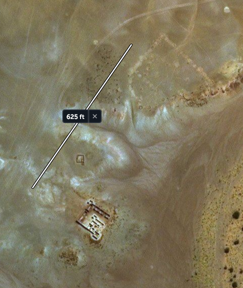
I suspect this one was buried by the great flood, not the destruction of the Ringed City.
I believe both events happened, the "sinking of the Ringed City", and the Great Flood. But not exactly like mike27 portrays. But both events as depicted in the ancient records are the result of the actions of the Ancient gods and are admitted to, by them.
If this were a crime investigation we have a situation where the criminals admits to what they have done, but the investigators constantly and continuously look to solve the crime by other means, by other "Natural" means. Oh they say, but these gods are nothing but myth, fantasy. They say they are not real therefore they could not be responsible. And at the very same time, these expert investigators look at ufo's and proclaim, "gee, it beats me what they are". Yes, they admit they are real now, but haven't a clue as to who they are. Pre flood, EVERYONE, knew who they were!
Noah's flood was accomplished for the very same reason the Ringed City was destroyed. In fact if the ancient records are correct, the flood and the destruction of the Ringed City were only separated by 2 years.
Noah's flood may not have actually happened the way the story tells it, but it is a real myth. It can be proven that the story was told by various cultures over a long period of time.
Yes, it actually happened! But not for the stated reasons. Mankind was becoming Noisy? We were full of sin? In who's eyes? In truth, the sin to the gods was that mankind, was becoming like the gods, becoming knowledgeable of the secrets of the gods, technology. That was the true sin. And the real reason mankind was to be set back, re started. They wanted us as originally designed, ignorant and obedient. And today, I can only see how proud the gods are for what they have accomplished with our ignorant superstitious humanity.
There is ample evidence from palaeobotanic and palaeoclimatic reconstructions that during early and mid-Holocene between some 11,700 years (in some regions, a few thousand years earlier) and some 4200 years ago, subtropical North Africa was much more humid and greener than today. This African Humid Period (AHP) was triggered by changes in the orbital forcing, with the climatic precession as the dominant pacemaker. Climate system modeling in the 1990s revealed that orbital forcing alone cannot explain the large changes in the North African summer monsoon and subsequent ecosystem changes in the Sahara. Feedbacks between atmosphere, land surface, and ocean were shown to strongly amplify monsoon and vegetation changes. Forcing and feedbacks have caused changes far larger in amplitude and extent than experienced today in the Sahara and Sahel. Most, if not all, climate system models, however, tend to underestimate the amplitude of past African monsoon changes and the extent of the land-surface changes in the Sahara. Hence, it seems plausible that some feedback processes are not properly described, or are even missing, in the climate system models.
That missing feedback process was identified in a computer simulation but thought too radical to identify and publish. Yes, it was just too outlandish, too far outside of the present paradigm, and as usual was rejected by our infallible investigators. But to be honest and fair not all investigators of the sciences are corrupted by the Paradigm (Matrix of Lies). They have been infiltrated by initiates of the gods, those "Experts" who you are expected to follow, but in reality are nothing but "Lunatics" spreading the falsehoods of their masters.
To the military and their contractors who have some of the most intelligent people alive you seem to have a bad habit of not believing something unless you discover it by means of covertness, as though everyone is lying. You even use "Remote Viewing" as a tool to discover the truth. Well, have you Remove Viewed the great flood, or the destruction of this Ringed City? Has anyone suggest you do that? Or are there some Lunatics in your chain of command that have forbade it? I dare you, go there now, and SEE what I see. Would you like me to share my Remove View??? And yes, I see that too, but that will remain, secret.
The truth, no matter what it is, will always remain the truth, no matter how many times you try to compartmentalize it. In the end, it will always reunite. "Remote Viewing" works both ways...........
At exactly 21°33'25.09"N 10°46'20.30"W You will find another buried structure, rectangular in shape. It sits to the northeast of a abandon modern structure.
I suspect this one was buried by the great flood, not the destruction of the Ringed City.
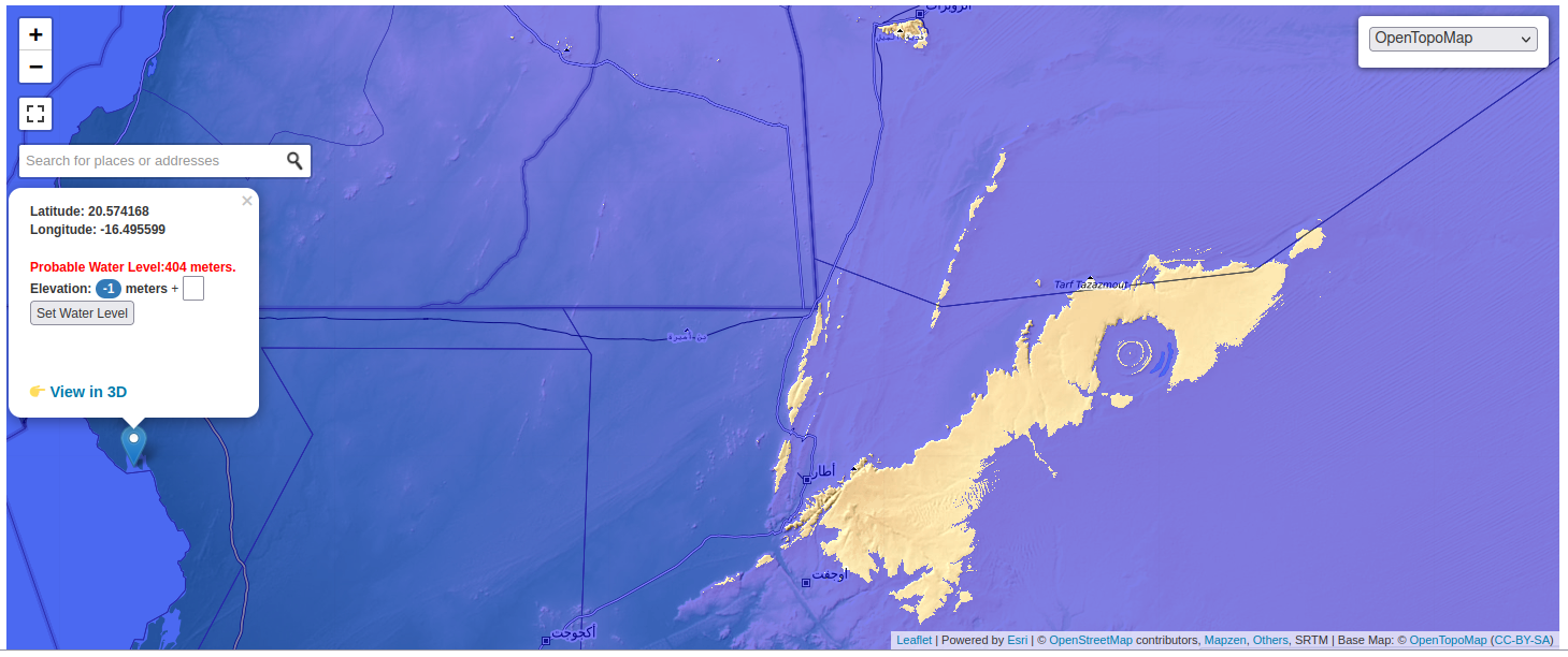
originally posted by: Mike27
a reply to: All Seeing Eye
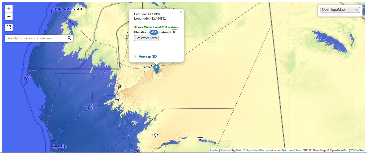
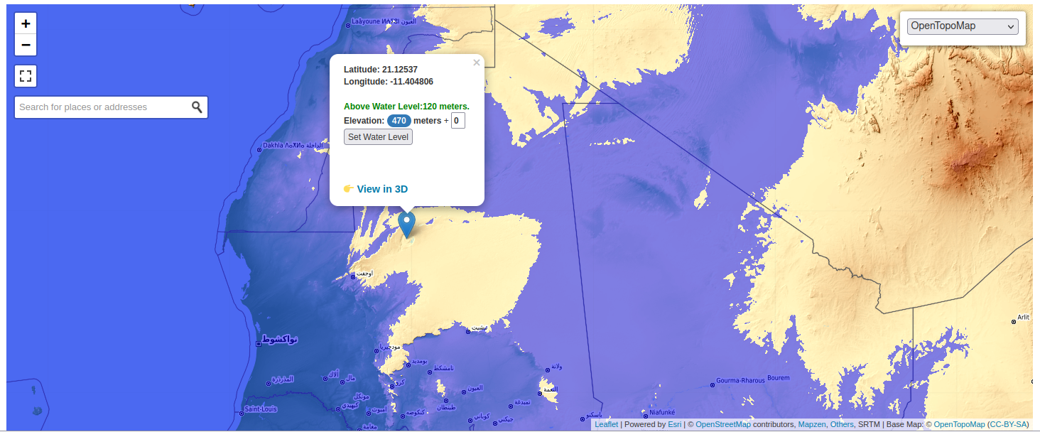
Only 405m of water required!
This view is not required with a realistic understanding of the African Humid period. There were many rivers and lakes, and, a rather large inland sea. These were quite capable of supplying water to the rings. Many are confusing the term "Ocean" with "Inland Sea".
originally posted by: Mike27
a reply to: All Seeing Eye
well what held the inland seas?
What holds the Inland Sea we call "The Great Lakes"? What holds the Mediterranean Inland Sea?
Depressions? Or as water likes to do, find low lying areas to run into. Until the depression is full then finds the weakest point of least resistance and overflows outwards towards a lower area. And if it cant do that it will continue to overfill its depression until, it can.
If you look at the plethora of research maps of this area you will see a vast amount of lakes and rivers. Some even have different names for the same bodies of water. If, you combine all these maps you will see they all fall within a zone, or low lying area. The estimates of rainfall go from very low to extreme amounts. Its a cinch your not going to find a lake on the side of a sloping mountain, its going to be in low depressions.
So, lets look at what is possible by looking at topographical maps. And low and behold, they all fall virtually in the same area, and its big. At its height of rainfall it could have theoretically been a inland, shallow sea of approx 1000 X 700 miles. And as this inland sea started to evaporate the waters would have receded into low lying areas, now separated from each other. Each one unique from each other leaving its own "Evidence". Until each one evaporate entirely leaving no water at all.
People overlook the amounts of possible rain. In my model I account for "Hurricanes" and the rainfall recorded in inches. Look at the "flooding" in the desert today when they only get 2 - 4 inches. Imagine what it would look like with 6 - 12 inches, in that flat terrain, year after year.
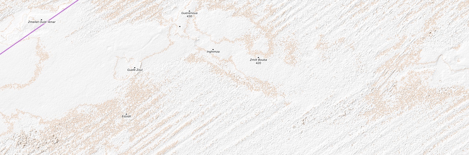
I tried to upload a image of the "Low Area" but was unsuccessful, for unknown reasons. So to those who are interested go to opentopomap.org...=6/21.525/-5.273 And look at the light green areas, inland. That is where the water would have pooled.
originally posted by: Mike27
a reply to: All Seeing Eye
Only 405m of water required!
What program is that? Can it be set to 250 - 310 meters??
originally posted by: All Seeing Eye
a reply to: bloodymarvelous
I believe both events happened, the "sinking of the Ringed City", and the Great Flood. But not exactly like mike27 portrays. But both events as depicted in the ancient records are the result of the actions of the Ancient gods and are admitted to, by them.
If this were a crime investigation we have a situation where the criminals admits to what they have done, but the investigators constantly and continuously look to solve the crime by other means, by other "Natural" means. Oh they say, but these gods are nothing but myth, fantasy. They say they are not real therefore they could not be responsible. And at the very same time, these expert investigators look at ufo's and proclaim, "gee, it beats me what they are". Yes, they admit they are real now, but haven't a clue as to who they are. Pre flood, EVERYONE, knew who they were!
Noah's flood was accomplished for the very same reason the Ringed City was destroyed. In fact if the ancient records are correct, the flood and the destruction of the Ringed City were only separated by 2 years.
The problem with Noah's flood is the species of animals and their distribution across the globe. With so many present day animals being located more or less in the same location where their ancestors of 20,000 + years also lived and died.
If there were a true world wide flood, then all surviving land animals would have lineages that are geographically traceable to a single location (wherever the Ark landed.)
Kangaroos would not be exclusively found in Australia.
But the Legend can be considered accurate enough to merit attention, because quite a lot of flooding did occur. Just not the whole planet. (Also if you were alive at the time, and got swept out to sea...... then how would you know the whole world hadn't been covered in water? Did Noah sail to Mt. Everest to take a look?)
a reply to: All Seeing Eye
Its on a plateau. I thought you could sail to Atlantis?
+210m
+350M
www.floodmap.net...
Its on a plateau. I thought you could sail to Atlantis?
+210m
+350M
www.floodmap.net...
edit on 3-6-2022 by Mike27 because: (no reason given)
a reply to: bloodymarvelous
I have been working on the "flood" longer than I have the Ringed City. You are correct.
The Flood itself was not perfect in that everyone and everything was destroyed. There were entire regions that suffered no effect while others received the full force. People in South America documented that they climbed the highest mountains to avoid the waters. If everyone was wiped out, there would be no one to carry forward "Any" legion of the event. So too with the animals, not all were destroyed.
What it did do was to destroy the global society, lanes of communication, and many coastal cities. Especially the ones that were established as homes of the gods. Mankind, along with any knowledge, was thrown violently into the stone age, once again. Mankind would no longer be "Managed" or educated by the gods. We were on our own.
So, yes and no, the great flood did and did not effect the entire globe. This is one of the main reasons the Ringed City was targeted 2 years later. Not enough of it was destroyed during the great flood. It required additional "Cleaning".
People would be surprised to learn that all the planet was not submerged under water at the same time. It was more of a rolling flood with the water that was already here. This is why, after a time, the waters subsided back to where it had come from.
Even the destruction of the Ringed City was not perfect, but then again, its goal was to destroy the Home of Poseidon, everything else was secondary. and this is why so many things in the area still exist today.
The reason for the great flood, again, was to set mankind back to a state of ignorance before the gods intervened and gave us knowledge. But even at this it really makes no sense. Could they not have controlled mankind and its progression? Something else must have been at play. Its almost as if some other force or thing was forcing their hand. Maybe even making a ultimatum to the gods. I see their attitude as a child who is told not to play with a certain toy, in a fit of childish rage they proclaim "Fine" as they throw the toy to the ground in a profound temper tantrum.
Yes there probably were "Favorite" bloodlines that were given a heads up, and Noah was probably one such.
But now instead of in the open the gods have chosen(Forced?) to rule by proxi, from the dark hidden places they inhabit. They never went anywhere, except into hiding.
Your logic is sound. These gods, are imperfect.
a reply to: All Seeing Eye
Here's an interesting event which happened at about the same time.
The Neglected Carolina Bays
Carolina bays
Here's an interesting event which happened at about the same time.
The Neglected Carolina Bays
Finally, Zamora relates the impact that occurred in the Great Lakes area, which led to the formation of the Carolina Bays and the Nebraska rainwater basins, to the impact event of the Younger Dryas (the recent Dryas, which occurred now between 12700 and 11500 years ago (4)). Although this impact event – as well as the relationship with the Carolina Bays (5) – was proposed as such by Firestone et al. in 2007, it was quickly dismissed by the non-impactors as invalid because no crater that could have produced it (the smoking gun), no evidence of shock metamorphism, and no geochemical anomalies indicative of material from space were found in sediments of that time. Regarding the fact that no crater has been found, it is to be expected when a planetary body impacts an ice layer of between 1 and 2 km thick. As there are no signs of shock metamorphism, we must first find materials that can preserve them (which is difficult since the crater and its proximal ejecta were obliterated by the flows generated by the melting of the ice; the only hope, for the moment, would be to drill in Lake Huron and in the bays to see if the ice fragments carried with them rocky materials from the impact zone)
Carolina bays
a reply to: Mike27
Thank you, never knew of these formations. But knowing what I know of the present Scientific Academia, I must be suspicious of its agenda. And red flags always go up when "Observations" are not the first mention. Just on the surface "who" observed this impact the author claims to have occurred in the great lakes? Are there even any local folklore that speak of it? At any rate. What is the authors true intention here, explain the formations, or, sell a book written in the"Babble" language.
Either way, I have had no time to ponder the formations, though at first glance they appear to have more in common with the ocean, than they do with the great lakes, though I doubt their formation is water related in a direct manner.
I must relinquish my opinion to one or two of the posters of comments in the following article.
Perigee Zero: Carolina Bays in the Midwest
Mike27, are you trying to drive me crazy? lol lol JK.
These formations are forgotten, because no realistic scientific process can be identified. And in truth belong in the "OOparts" bin. Same bin the "Cart Ruts" are in. And no one really wants to go there because of the Fringe label. We have "foot Prints", but no foot present in our present, "Paradigm".
What direction does the trade winds blow, over these depressions?
virily.com...
Just a thought...
Then on the outside of the Paradigm, what was harvested?
Any ways, thanks for sharing.
Thank you, never knew of these formations. But knowing what I know of the present Scientific Academia, I must be suspicious of its agenda. And red flags always go up when "Observations" are not the first mention. Just on the surface "who" observed this impact the author claims to have occurred in the great lakes? Are there even any local folklore that speak of it? At any rate. What is the authors true intention here, explain the formations, or, sell a book written in the"Babble" language.
Either way, I have had no time to ponder the formations, though at first glance they appear to have more in common with the ocean, than they do with the great lakes, though I doubt their formation is water related in a direct manner.
I must relinquish my opinion to one or two of the posters of comments in the following article.
Perigee Zero: Carolina Bays in the Midwest
Forget subterrainean sources. And the material that impacted to create the bays didn’t survive the trip. The steam explosions were only in the LIS.(The pristine hydrothermal burn marks at the points of origin are not hard to find) That’s what launced them. I don’t think the ballistic ice, and slush, fragments had as much velocity as you seem to attribute to them. They would not have been solid chunks of ice. By the time they hit, they would have been semi-melted blobs of water, and slush. So the CB impactors didn’t hit; they splashed.
As for that ‘Old Earth’ paradigm, try a subtle shift in emphasis. Think old Earth-paradigm. The Earth’s old all right. Very, very old. It’s just that some of the surface terrains of North America that we’ve always assumed to be ancient, are brand spankin’ new. All of the Earth sciences are founded on the unquestioned, 19th century assumptions of uniform,gradual change, and the principle idea that ‘The Present is the key to understanding the past’. And yet, the simple empirical fact, is that it isn’t. In fact, there has been nothing in the short period of time referred to as ‘written history’ that gives us any clue at all as to the level of catastrophic, mass extinction, violence which has happened in geologically recent, human times.
We find ourselves at the cusp of a major paradigm shift in the Earth sciences that will change them all down to their very foundations. And that paradigm shift will be every bit as far reaching as the realization that the world isn’t flat.
The CB’s cannot be explained by any phenomena in the standard, assumptive, uniformitarian landform theory toolkit. You have to look at them from the other side of the paradigm shift. Or they’ll drive you crazy.
Mike27, are you trying to drive me crazy? lol lol JK.
These formations are forgotten, because no realistic scientific process can be identified. And in truth belong in the "OOparts" bin. Same bin the "Cart Ruts" are in. And no one really wants to go there because of the Fringe label. We have "foot Prints", but no foot present in our present, "Paradigm".
What direction does the trade winds blow, over these depressions?
virily.com...
Just a thought...
Then on the outside of the Paradigm, what was harvested?
Any ways, thanks for sharing.
new topics
-
iPhone Microphone Being Accessed by Unknown App
Rant: 1 hours ago -
Democrats send letter to Biden urging him to ratify Equal Rights Amendment
US Political Madness: 7 hours ago
top topics
-
Democrats send letter to Biden urging him to ratify Equal Rights Amendment
US Political Madness: 7 hours ago, 2 flags -
iPhone Microphone Being Accessed by Unknown App
Rant: 1 hours ago, 2 flags
active topics
-
George Stephanopoulos and ABC agree to pay $15 million to settle Trump defamation suit
Mainstream News • 26 • : Lazy88 -
Mood Music Part VI
Music • 3736 • : Hellmutt -
Only two Navy destroyers currently operational as fleet size hits record low
Military Projects • 25 • : Oldcarpy2 -
-@TH3WH17ERABB17- -Q- ---TIME TO SHOW THE WORLD--- -Part- --44--
Dissecting Disinformation • 3716 • : RelSciHistItSufi -
Democrats send letter to Biden urging him to ratify Equal Rights Amendment
US Political Madness • 4 • : VictorVonDoom -
Light from Space Might Be Travelling Instantaneously
Space Exploration • 30 • : cooperton -
Drones everywhere in New Jersey ---and Elsewhere Master Thread
Aliens and UFOs • 175 • : nugget1 -
iPhone Microphone Being Accessed by Unknown App
Rant • 0 • : Roma1927 -
The Acronym Game .. Pt.4
General Chit Chat • 1017 • : JJproductions -
Defending the need for adherence to Old Testament commandments under the new covenant of Christ
Conspiracies in Religions • 27 • : FlyersFan