It looks like you're using an Ad Blocker.
Please white-list or disable AboveTopSecret.com in your ad-blocking tool.
Thank you.
Some features of ATS will be disabled while you continue to use an ad-blocker.
share:
a reply to: carewemust
I am sorry for all those affected ( although it is a state built on a swamp in hurricane territory)the media once again overplayed its hand I was expecting a Chevy deposited in every swimming pool they should stick to facts not opinions and the fact is Cuba saved Florida's ass.
I am sorry for all those affected ( although it is a state built on a swamp in hurricane territory)the media once again overplayed its hand I was expecting a Chevy deposited in every swimming pool they should stick to facts not opinions and the fact is Cuba saved Florida's ass.
In Saint Lucie County on the east coast, it's very nasty here we are getting 70+ mph gust, trees down, flooding, and no power. Tornado warnings every
20 minutes. Usually the winds come from the east and push the trees in the lot the opposite direction of my house, but now branches are landing on my
roof left and right. Sure hope a trees doesn't come through my roof.
Be safe everyone, stay inside
Be safe everyone, stay inside
a reply to: khnum
Yeah Cuba was sort of a mixed blessing for Florida. The wind's dropped over Cuba but the landmass seems to have slowed irma down enough for it to make that North turn and go into Florida. Prior to that it was just chugging along West Northwest and who knows where Irma would be headed and strengthening back to a category five.
Yeah Cuba was sort of a mixed blessing for Florida. The wind's dropped over Cuba but the landmass seems to have slowed irma down enough for it to make that North turn and go into Florida. Prior to that it was just chugging along West Northwest and who knows where Irma would be headed and strengthening back to a category five.
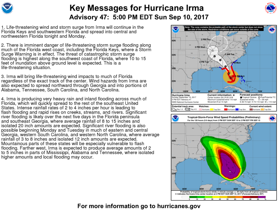
Hurricane Irma Discussion Number 47
NWS National Hurricane Center Miami FL AL112017
500 PM EDT Sun Sep 10 2017
Irma made landfall a couple of hours ago near Marco Island,
Florida with an estimated intensity of 100 kt. The eye just
passed over Naples, and assuming some decay over land, the current
intensity estimate is 95 kt. The interaction with the Florida
Peninsula along with strong southwesterly shear should cause
significant weakening, but Irma's large and powerful circulation
will likely maintain hurricane strength until Monday morning at the
earliest. Irma should be well inland and weaken to a remnant low in
72 hours. The official intensity forecast is above the model
consensus.
Center fixes indicate a slightly west of due northward motion at
about 350/12 kt. Global models indicate that Irma is embedded
within a broader cyclonic mid-level gyre. The cyclone is expected
to be steered around the eastern side of this gyre over the next few
days. This will take the system inland over the southeastern
United states within a day or so. The track guidance remains in
good agreement, and the official forecast is close to the model
consensus with a slight lean toward the ECMWF solution. This is
very close to the previous NHC track.
NHC
edit on 10-9-2017 by violet because: (no reason given)
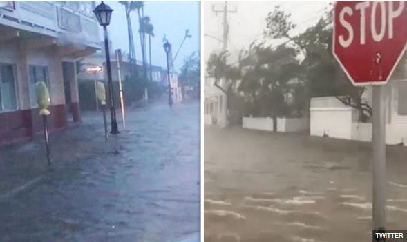
Here are pictures of the storm surge on Key West. (There is video at the linked page.)
www.express.co.uk...

More video of the Key West storm surge.
twitter.com...
I haven't heard CBSN talk about the Key West storm surge at all. It doesn't seem to be something they are reporting. I guess all eyes are on the eye of the hurricane.
www.express.co.uk...

edit on 10-9-2017 by ipsedixit because: (no reason given)
More video of the Key West storm surge.
twitter.com...
I haven't heard CBSN talk about the Key West storm surge at all. It doesn't seem to be something they are reporting. I guess all eyes are on the eye of the hurricane.
edit on 10-9-2017 by ipsedixit because: (no reason given)
originally posted by: ipsedixit
I haven't heard CBSN talk about the Key West storm surge at all. It doesn't seem to be something they are reporting. I guess all eyes are on the eye of the hurricane.
I think there is no power in the Keys....not that no one wants to report....just trouble getting feeds out.
I hope those who stayed survive the storm.
weather.com...
I've been watching TWC off and on for some time.
Looking at the radar, the high winds and torrential rain is going far further inland than I thought it would.
edit on Sun Sep 10 2017 by
DontTreadOnMe because: (no reason given)
a reply to: DontTreadOnMe
I'm sure you are right but they don't even seem to be trying to contact anyone on the Keys. They don't talk about the situation there at all. I find it a little strange. You'd think somebody would contact the Coast Guard. The Keys would have to be a very busy spot for them, I would imagine.
I'm sure you are right but they don't even seem to be trying to contact anyone on the Keys. They don't talk about the situation there at all. I find it a little strange. You'd think somebody would contact the Coast Guard. The Keys would have to be a very busy spot for them, I would imagine.
edit on 10-9-2017 by ipsedixit because: (no reason given)
a reply to: ipsedixit
I think I read there was somebody going out with a plane to check. I'll see if I can find where I read that
Ok here:
I think I read there was somebody going out with a plane to check. I'll see if I can find where I read that
Ok here:
A huge airborne relief mission is en route to the Keys to help people impacted by the tragic devastation caused when the eye of Hurricane Irma blasted through the Lower Florida Keys at daybreak Sunday morning.
Monroe County Emergency Management Director Martin Senterfitt called the destruction caused by Irma, a massive Category 4 storm when it impacted the Keys, a “humanitarian crisis.”
Among the services coming to the Keys are “disaster mortuary teams,” he told the conference call.
United States Air Force special operations pilots are testing flights with C-130 cargo planes around the massive storm from Mississippi to the Keys in anticipation of the mission, which will include Air National Guard flights of more C-130s and helicopters following the fixed-wing flights.
“The help is on its way,” Senterfitt said during a conference call Sunday afternoon.
Source
edit on 10-9-2017 by violet because: (no reason given)
a reply to: violet
pfft... Irma so scared of Tampa it dropped down a notch. I spent some time driving around town to get various parts of the bay empty of its water. I screwed up though and had to ride the bridge all the way to St. Pete on 275. Man they really need to label those better. Anyways here are some videos. I went to Causeway, Cypress Point, Bayshore Blvd, and the Hillsborough river near the bridge at Hillsborough avenue.
Homeowners along the river currently have their boats sitting in mud. Unfortunately those boats will probably end up on their driveways after the surge comes in.
a reply to: ipsedixit
see this post by dreamingawake on the previous page....couple links saying planes are on the way with aid:
www.abovetopsecret.com...
see this post by dreamingawake on the previous page....couple links saying planes are on the way with aid:
www.abovetopsecret.com...
a reply to: DontTreadOnMe
I'm sure the responders are on it. It just seemed strange that there was no mention of the situation in the Keys on CBSN. I guess they are concentrating on what people are facing rather than what has happened.
I'm sure the responders are on it. It just seemed strange that there was no mention of the situation in the Keys on CBSN. I guess they are concentrating on what people are facing rather than what has happened.
originally posted by: alphabetaone
a reply to: 8675309jenny
The stormsurge, not the eye. If the brunt of the stormsurge was distributed in the Everglades, then the rest of Irma would have had time to weaken while tracking over land. In this case, the more time this thing could have spent over land, the better off everyone is. Just not working out that way.
The upside is that the atmospheric conditions are becoming unfavorable, warm water or not so they're fighting against each other.
The storm surge is created by the winds though, collectively. And the everglades isn't really making "landfall", it's just more water to push somewhere. The eye would have strengthened, which pulls all the rest of the bands with it faster.
Sorry if I'm coming off as pedantic, I really just think it would have been worse if a big storm surge got pushed UP into the glades, especially with initial winds prevailing NW, it would have swamped everything from Bradenton south, Punta Gorda, Port Charlotte, Ft Myers. Everything would be under like 18ft of water. And that's assuming the dike held.
The 1928 Hurricane drowned I think 3000 people back when the SFLpopulation was 1/10th what it is today. If the storm came up the everglades it would have been worse IMHO.
a reply to: worldstarcountry
Thanks for sharing your videos
That's amazing that it sucks up water like that. I never even knew this until I saw the Bahamas robbed of its water.
That weather guy chad on CNN says it carries it along in a bubble underneath it & drops it off further up. Which can cause the flash floods or surges
Well they did teach us in school that water 💦 in the oceans are what causes our storms, then it's put back down with rainfall. A big recycling going on all the time.
Anyways you made it out of this thing alive and that's good 😊
edit on 10-9-2017 by violet because: (no reason given)
Marathon reportedly underwater:
www.flkeysnews.com...=trending
And on a sad note (or a bad omen?)
www.flkeysnews.com...=trending
Larry Kahn, editor of the Keynoter and an editor for FlKeysNews.com, reported from one of Monroe County’s four “refuges of last resort” — a shelter set up at Marathon High School on Sombrero Road, that power was out, there was no running water, and everything outside was submerged by storm surge and rain.
“Everything is underwater, I mean everything,” Kahn said.
And on a sad note (or a bad omen?)
To make matters worse, one of the estimated 50 people staying at the shelter died overnight. Kahn said he was told by a Sheriff’s Office deputy that the man died of natural causes.
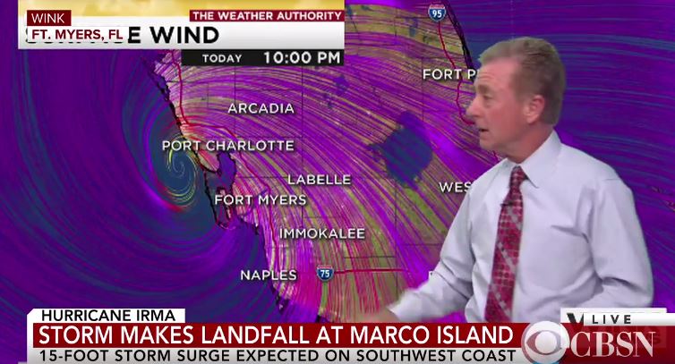
Also, here's a live feed out of Ft Myers, assuming it hasn't been posted yet.
The live feed shows just because it's not a Category 5 behemoth doesn't mean it's all roses and unicorn farts. Irma has had a lot of fun throwing around a lot of water and tornadoes along with the winds.
The live feed shows just because it's not a Category 5 behemoth doesn't mean it's all roses and unicorn farts. Irma has had a lot of fun throwing around a lot of water and tornadoes along with the winds.
new topics
-
Bizarre Labour Party Tic Toc Video Becomes Even More Embarrassing
Regional Politics: 13 minutes ago -
Potter to WHU
World Sports: 5 hours ago -
Dr. Demento
Music: 7 hours ago -
The elephant in the room (wearing a hoodie)
US Political Madness: 7 hours ago
top topics
-
The elephant in the room (wearing a hoodie)
US Political Madness: 7 hours ago, 13 flags -
To become president, Zelensky had to learn Ukrainian
Political Conspiracies: 14 hours ago, 7 flags -
Dr. Demento
Music: 7 hours ago, 6 flags -
Potter to WHU
World Sports: 5 hours ago, 2 flags -
Bizarre Labour Party Tic Toc Video Becomes Even More Embarrassing
Regional Politics: 13 minutes ago, 1 flags
active topics
-
Los Angeles brush fires latest: 2 blazes threaten structures, prompt evacuations
Mainstream News • 189 • : xuenchen -
President Carter has passed
Mainstream News • 48 • : angelchemuel -
Bizarre Labour Party Tic Toc Video Becomes Even More Embarrassing
Regional Politics • 0 • : gortex -
The Fight for Election Integrity Continues -- Audits, Criminal Investigations, Legislative Reform
2024 Elections • 4372 • : IndieA -
What Comes After January 20th
Mainstream News • 35 • : JadedGhost -
Potter to WHU
World Sports • 3 • : gortex -
The Truth about Migrant Crime in Britain.
Social Issues and Civil Unrest • 42 • : gortex -
Post A Funny (T&C Friendly) Pic Part IV: The LOL awakens!
General Chit Chat • 8007 • : underpass61 -
Planned Civil War In Britain May Be Triggered Soon
Social Issues and Civil Unrest • 29 • : AdultMaleHumanUK -
The elephant in the room (wearing a hoodie)
US Political Madness • 19 • : xuenchen


