It looks like you're using an Ad Blocker.
Please white-list or disable AboveTopSecret.com in your ad-blocking tool.
Thank you.
Some features of ATS will be disabled while you continue to use an ad-blocker.
share:
a reply to: 8675309jenny
You're not coming off that way. You can disagree, I just happen to think you're wrong about that, but honestly it's somewhat counter-productive to be petty arguing it here.
You're not coming off that way. You can disagree, I just happen to think you're wrong about that, but honestly it's somewhat counter-productive to be petty arguing it here.
Cat 2 now
Just saw on tv it's heading to Tampa?
EDIT
It shifted east eyeing Orlando
Tampa will get storm surge
Just saw on tv it's heading to Tampa?
EDIT
It shifted east eyeing Orlando
Tampa will get storm surge
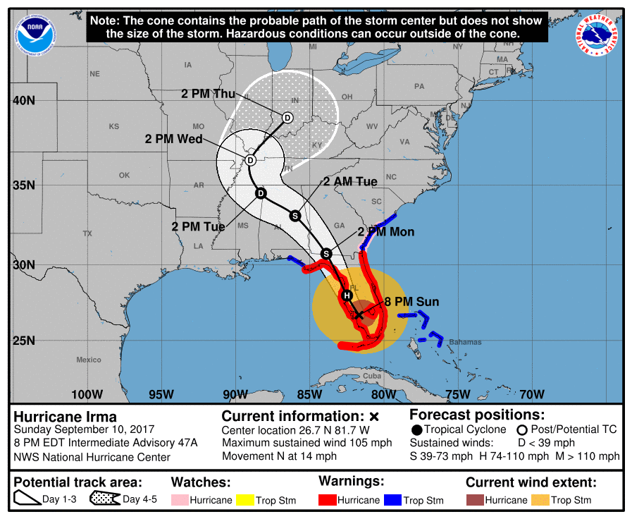
...IRMA MOVING NORTHWARD NEAR FT. MYERS... ...DANGEROUS STORM SURGES EXPECTED IN AREAS OF ONSHORE WINDS ALONG THE FLORIDA WEST COAST...
As of 0800 PM EDT Sun Sep 10 (Advisory # 47A)
Saffir-Simpson Wind Scale: Category 2
Maximum Sustained Winds: 90 knots; 105 mph
Minimum Central Pressure: 942 mb
Located at: 26.7N 81.7W
Movement: north at 12 knots; 14 mph
NHC
edit on 10-9-2017 by violet because: (no reason given)
edit on 10-9-2017 by violet because: (no reason
given)
edit on 10-9-2017 by violet because: (no reason given)
a reply to: violet
Tampa will likely be spared from major surge with the storm going more east. They will miss the strong southwest winds that would pile the water into the bay.
I am doing ok in Saint Augustine, downtown was flooded earlier, have not ventured out to check on things since this afternoon.
I am riding it out on my boat in a hurricane hole. Transformers are starting blow out everywhere. I have enough of a battery bank to keep my cell phone charged and my lights on. It is gusting over 60mph at the NWS station and we are over 200miles from the center.
edit on 10-9-2017 by
jrod because: Celltypo
I just came back from clearing some huge tree branches off of Himes as well as MLK going towards the Hospital in front of Bucs training camp. Picked
up some homeless folks getting their arse kicked and dropped them off at the parking garage next to St. Josephs. They are alot more relaxed now. One
of the fellas is clearly pretty much mostly gone on the head already, but there still enough of him left to promise to pay me something. I can't
understand why he thinks I was doing this for money. I just told him he can pay me by staying dry and safe, and left them with two bags of canned
goods.
I went ahead and drove up to the ninth floor and enjoyed the view. Here it is for anybody that is interested.
Theres a tree down blocking one of the main neighborhood roads, good thing there are two routes around it. Hopefully it will be clear enough tomorrow for me to cut it up with the chainsaw. Unfortunately that means the one at my house must have dropped by now. I will check on it later tonight.
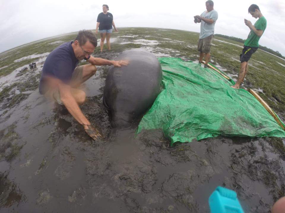
Two manatees stranded when water was sucked out of bays and waterways by Irma, were rescued in Manatee County.

Source
On Facebook

Source
On Facebook
edit on 10-9-2017 by DancedWithWolves
because: (no reason given)
a reply to: worldstarcountry
Thanks for the video.
That was nice of you to help out the homeless folk
Thanks for the video.
That was nice of you to help out the homeless folk
originally posted by: ProphetZoroaster
Waste of flesh cowards..
As of if it's not challenging enough for people in Fla you have dumb criminals doing things like this..
Sadly so many clips out there showing people looting sneakers during the storm..
a reply to: ProphetZoroaster
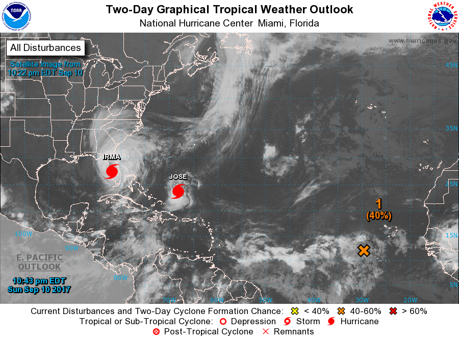
That dry air is going to get entrained in Irma and take a lot of steam out of the storm in the next few days.
Still doing damage though.
That dry air is going to get entrained in Irma and take a lot of steam out of the storm in the next few days.
Still doing damage though.
..IRMA PRODUCING HURRICANE-FORCE WINDS ACROSS PORTIONS OF CENTRAL FLORIDA
As of 1100 PM EDT Sun Sep 10 (Advisory # 48)
Saffir-Simpson Wind Scale: Category 2
Maximum Sustained Winds: 85 knots; 100 mph
Minimum Central Pressure: 952 mb
Located at: 27.5N 81.9W
Movement: north at 12 knots; 14 mph
Discussion
Due to its recent more inland push, Irma's center is now
forecast to remain over Florida and then move over the southeastern
United States for the duration of its existence. Due to continued
land interaction and strong shear of over 30 kt, Irma should
continue to lose strength and fall below hurricane intensity
on Monday. The cyclone is then expected to become a remnant low
over western Tennessee by day 3 and dissipate by day 4.
NHC
edit on 10-9-2017 by violet because: (no reason given)
edit on 10-9-2017 by violet
because: (no reason given)
a reply to: carewemust
Agreed i said the same when I watched that clip here, thrill seekers do love putting their life on the line.
Agreed i said the same when I watched that clip here, thrill seekers do love putting their life on the line.
new topics
-
Of course it was DEI
Dissecting Disinformation: 10 hours ago
top topics
-
Of course it was DEI
Dissecting Disinformation: 10 hours ago, 7 flags -
2nd Day Thanksgiving!...(leftovers!!)
General Chit Chat: 12 hours ago, 3 flags
active topics
-
Of course it was DEI
Dissecting Disinformation • 11 • : TzarChasm -
V.P. Kamala Harris releases a video and nobody understands why
US Political Madness • 102 • : anned1 -
I thought Trump was the existential threat?
World War Three • 124 • : andy06shake -
Mass UAP events. DC. Machester Airport, UFOs over sub base in CT, Nuke bases.
Aliens and UFOs • 26 • : CosmicFocus -
Unidentified Flying Objects Over U.S. Military Bases in Northeast UK, as of roughly 11 a.m. CST.
Aliens and UFOs • 34 • : bastion -
Post A Funny (T&C Friendly) Pic Part IV: The LOL awakens!
General Chit Chat • 7850 • : KrustyKrab -
-@TH3WH17ERABB17- -Q- ---TIME TO SHOW THE WORLD--- -Part- --44--
Dissecting Disinformation • 3417 • : brewtiger123 -
2nd Day Thanksgiving!...(leftovers!!)
General Chit Chat • 6 • : DontTreadOnMe -
New Disney Star Wars Films Failing Test of Time?
Movies • 18 • : Popoll -
The Party of Peace - Trump Cabinet Picks Targeted with Death Threats
US Political Madness • 51 • : RazorV66


