It looks like you're using an Ad Blocker.
Please white-list or disable AboveTopSecret.com in your ad-blocking tool.
Thank you.
Some features of ATS will be disabled while you continue to use an ad-blocker.
share:
Decent sized aftershock of the 5.792Mw at Leaping Burn, Wanaka last night NZST, closer to the Niger Thrust Fault
ID: 2015p376663 Network: geonet
Status: confirmed
Date/Time NZST: 20/05/2015 20:46:28
Date/Time UTC: 20/05/2015 08:46:28
Latitude, Longitude: -44.5087, 168.8456
Magnitude: 4.02
Depth: 6.08 km
Energy Released: 16.0475 tonnes of TNT
Location: Wakatipu-Waimate
www.geonet.org.nz...
nzeq2015.blogspot.co.nz...
a reply to: muzzy
Hey Muzzy,
Was curious if you heard of this theory?
Source
I tend to be skeptical about this since they only used 100 years and why not try to look back farther? Wanted your opinion on it if you had time.
Not sure you have read about this also?
Source
Outside noise triggering a volcano?
thanks for your time.
Hey Muzzy,
Was curious if you heard of this theory?
Earth is now in a seismically active period according to quake cluster theory
Following the second major earthquake that hit Nepal on 12 May, some scientists believe we could be seeing a seismically active period that began in 2004 and could end around 2019.
Great earthquakes of magnitude 8.5 or higher occur infrequently but are found to cluster in time, says Chadha, based on the analysis of 115 years of global data. Such "clustering" is not found for magnitudes lesser than 8.0 which show an annual average of about 15 to 16 every year, globally.
Data analysed from 1900 onwards based on the catalogue available with United States Geological Survey (USGS) indicate there have been three possible periods of clustering of magnitude 8.5 or greater, lasting 15 years, which can also be referred to as "periods of seismic activation" of great earthquakes, he told IBTimes UK.
Source
I tend to be skeptical about this since they only used 100 years and why not try to look back farther? Wanted your opinion on it if you had time.
Not sure you have read about this also?
‘Drumbeat’ volcano earthquakes triggered by external noise – study
The Yekaterinburg team decided to test a mathematical model of this stick-slip motion, but also added another factor – outside noise projected onto the volcano.
What they found was revealing – not only did the noise contribute to the oscillations, but relatively small sound waves could produce a disproportionate destabilizing effect, with the volcano seeming to dance to the beat of the white noise coming in from outside.
The team now hopes to apply their findings in a practical area – forecasting eruptions, by understanding the mechanisms within volcanoes. They admit, however, there are still too many variables to be able to use mathematical models like theirs to predict real eruptions.
Source
Outside noise triggering a volcano?
thanks for your time.
originally posted by: muzzy
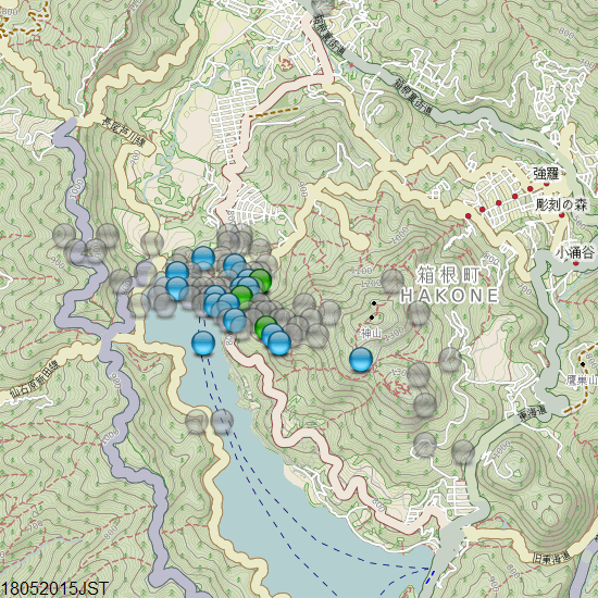
Hakone still popping, 97 events of the 18th JST, 3 of them M2's, still nestling at the north end of Lake Ashi.
Seems to have eased off on the 19th, only 39 events.
May be over, only 19 events on the 20th, all micro's
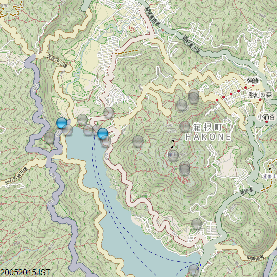
I'll see if I can get that animation and a graph done later today.
M6.0 - 56km SE of Honiara, Solomon Islands
9.776°S 160.330°E depth=10.0 km (6.2 mi)
Time
2015-05-21 19:32:57 (UTC)
2015-05-21 14:32:57 (UTC-05:00) in your timezone
Times in other timezones
Nearby Cities
56km (35mi) SE of Honiara, Solomon Islands
659km (409mi) SE of Arawa, Papua New Guinea
978km (608mi) NW of Luganville, Vanuatu
1073km (667mi) SE of Kokopo, Papua New Guinea
56km (35mi) SE of Honiara, Solomon Islands
USGS
Odd location
earthquake.usgs.gov...
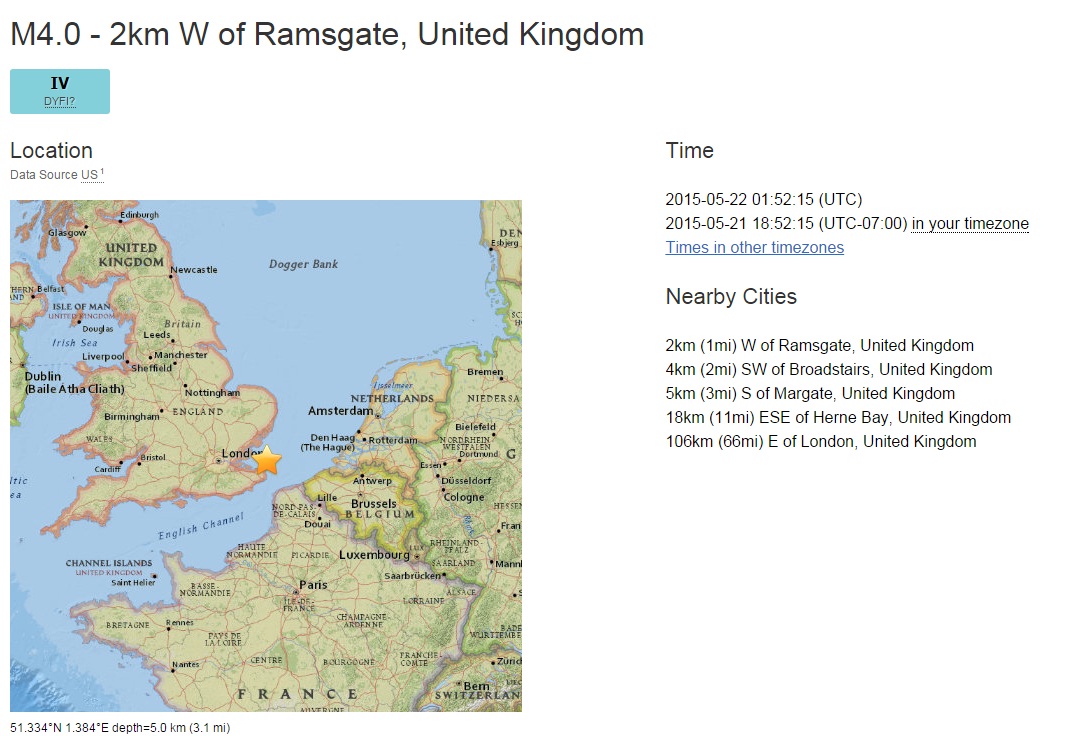
M4.0
- 2km W of Ramsgate, United Kingdom
Time
2015-05-22 01:52:15 (UTC)
2015-05-21 18:52:15 (UTC-07:00) in your timezone
Times in other timezones
Nearby Cities
2km (1mi) W of Ramsgate, United Kingdom
4km (2mi) SW of Broadstairs, United Kingdom
5km (3mi) S of Margate, United Kingdom
18km (11mi) ESE of Herne Bay, United Kingdom
106km (66mi) E of London, United Kingdom
files.abovetopsecret.com...
earthquake.usgs.gov...
M4.0
- 2km W of Ramsgate, United Kingdom
Time
2015-05-22 01:52:15 (UTC)
2015-05-21 18:52:15 (UTC-07:00) in your timezone
Times in other timezones
Nearby Cities
2km (1mi) W of Ramsgate, United Kingdom
4km (2mi) SW of Broadstairs, United Kingdom
5km (3mi) S of Margate, United Kingdom
18km (11mi) ESE of Herne Bay, United Kingdom
106km (66mi) E of London, United Kingdom

files.abovetopsecret.com...
edit on 7/30/2012 by dreamfox1 because: UK
M 4.2 - 12km NW of Vacaville, California
Time
2015-05-22 02:53:00 (UTC)
2015-05-21 19:53:00 (UTC-07:00) in your timezone
Times in other timezones
Nearby Cities
9km (6mi) ENE of Yountville, California
14km (9mi) N of Napa, California
23km (14mi) NE of Sonoma, California
24km (15mi) WNW of Vacaville, California
68km (42mi) WSW of Sacramento, California
M4.1 - 9km ENE of Yountville, California
Time
2015-05-22 02:53:00 (UTC)
2015-05-21 19:53:00 (UTC-07:00) in your timezone
Times in other timezones
Nearby Cities
9km (6mi) ENE of Yountville, California
14km (9mi) N of Napa, California
23km (14mi) NE of Sonoma, California
25km (16mi) WNW of Vacaville, California
68km (42mi) WSW of Sacramento, California
Time
2015-05-22 02:53:00 (UTC)
2015-05-21 19:53:00 (UTC-07:00) in your timezone
Times in other timezones
Nearby Cities
9km (6mi) ENE of Yountville, California
14km (9mi) N of Napa, California
23km (14mi) NE of Sonoma, California
24km (15mi) WNW of Vacaville, California
68km (42mi) WSW of Sacramento, California
edit on 7/30/2012 by dreamfox1 because: (no reason given)
edit on 7/30/2012 by dreamfox1 because: (no reason
given)
M4.1 - 9km ENE of Yountville, California
Time
2015-05-22 02:53:00 (UTC)
2015-05-21 19:53:00 (UTC-07:00) in your timezone
Times in other timezones
Nearby Cities
9km (6mi) ENE of Yountville, California
14km (9mi) N of Napa, California
23km (14mi) NE of Sonoma, California
25km (16mi) WNW of Vacaville, California
68km (42mi) WSW of Sacramento, California
edit on 7/30/2012 by dreamfox1 because: (no reason given)
Hey Muzzy mate.
Just did my usual check on RSOE.
I do not remember ever seeing New Zealand quite this busy. Lots of smaller EQs
Is it just me or is something up?
Alaska is also busy although that is not unusual.
I do not remember seeing a quake so close to England. I expected it to be far out at sea, but no, it was not. Very unusual.
P
edit on 21/5/2015 by pheonix358 because: Spelt Muzzy's name with a pair of s.
a reply to: pheonix358
Not that I noticed, usually about 50 per day M1+
I haven't checked for today yet, just back home now.
Not that I noticed, usually about 50 per day M1+
I haven't checked for today yet, just back home now.
a reply to: lurksoften
I hadn't heard of a specific theory like that, but the time period is way too short to be able to say such a thing IMO, how many M9's in 100 years? 6?
Depends how you twist the data I guess.
I'll do a graph when I get a minute, time versus magnitude, that should show it right away
count them yourselves
the whole list of M8+'s is there too
significantearthquakes.blogspot.co.nz...
originally posted by: muzzy
a reply to: pheonix358
Not that I noticed, usually about 50 per day M1+
I haven't checked for today yet, just back home now.
just checked
Not sure what time span you were looking at on RSOE, but today was one of the lowest numbers this year, 28.
But 7 of those were mag 3's, so the radiated energy released was "safe" at 27.65TTNT (below 6TTNT is "unsafe", as it means pressure is building)
M5.3 - 39km SSW of Caliente, Nevada
37.292°N 114.655°W depth=4.0 km (2.5 mi)
Time
2015-05-22 18:47:43 (UTC)
2015-05-22 13:47:43 (UTC-05:00) in your timezone
Times in other timezones
Nearby Cities
39km (24mi) SSW of Caliente, Nevada
78km (48mi) NW of Mesquite, Nevada
101km (63mi) WNW of Saint George, Utah
107km (66mi) W of Washington, Utah
455km (283mi) SSW of Salt Lake City, Utah
USGS
After shock of 3.8
USGS has it in red assuming it was felt by alot of people.
edit on 22-5-2015 by lurksoften because: (no reason given)
edit on
22-5-2015 by lurksoften because: Rev 5.4 to 5.3
a reply to: lurksoften
A few more since then.
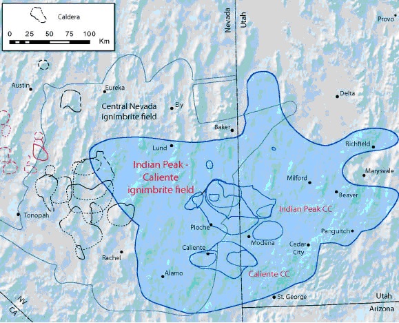
That 5.4 got me looking into the area and lo and behold...
Link
A few more since then.
2.4
Nevada
2015-05-22 19:16:03 UTC3.0 km
1.2
33km S of Caliente, Nevada
2015-05-22 19:14:16 UTC15.0 km
3.8
38km SSW of Caliente, Nevada
2015-05-22 19:05:23 UTC9.0 km
2.0
35km SSE of Caliente, Nevada
2015-05-22 19:02:15 UTC1.5 km
5.4
39km SSW of Caliente, Nevada
2015-05-22 18:47:42 UTC4.2 km
That 5.4 got me looking into the area and lo and behold...
Link
Geologists from Brigham Young University, Berkeley Geochronology Center and the Pacific Northwest National Laboratory have found evidence of twenty ancient supervolcanoes near the Utah-Nevada border.
The team also found evidence of 15 super-eruptions and 20 large calderas – the so-called Indian Peak-Caliente caldera complex.
These supervolcanoes have diameters up to 60 km and are filled with intracaldera tuff and breccias. They have been hidden in plain sight for millions of years despite their enormous size.

edit on 5/22/2015 by whatnext21 because: (no reason given)
originally posted by: lurksoften
M5.4 - 39km SSW of Caliente, Nevada
37.296°N 114.703°W depth=19.4 km (12.0 mi)
Time
2015-05-22 18:47:43 (UTC)
2015-05-22 13:47:43 (UTC-05:00) in your timezone
Times in other timezones
Nearby Cities
39km (24mi) SSW of Caliente, Nevada
78km (48mi) NW of Mesquite, Nevada
101km (63mi) WNW of Saint George, Utah
107km (66mi) W of Washington, Utah
455km (283mi) SSW of Salt Lake City, Utah
USGS
After shock of 3.8
USGS has it in red assuming it was felt by alot of people.
Vegas here. Didn't feel a thing.
Here is that Hakone Animation, I had to start from scratch, got my W8 laptop back, different sized screen to Notebook.
Seems to have died away, only 4 quakes on the 20th JST, 4 x ~M1's
Summary
mag~1= 1064
mag1= 206
mag2= 18
total= 1288
TTNT= 13.635
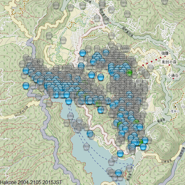
the animation is here (too big for ATs (4MB))
Seems to have died away, only 4 quakes on the 20th JST, 4 x ~M1's
Summary
mag~1= 1064
mag1= 206
mag2= 18
total= 1288
TTNT= 13.635

the animation is here (too big for ATs (4MB))
M6.8 - 205km ESE of Kirakira, Solomon Islands
11.086°S 163.685°E depth=8.0 km (5.0 mi)
Time
2015-05-22 21:45:22 (UTC)
2015-05-22 16:45:22 (UTC-05:00) in your timezone
Times in other timezones
Nearby Cities
213km (132mi) W of Lata, Solomon Islands
466km (290mi) ESE of Honiara, Solomon Islands
613km (381mi) NW of Luganville, Vanuatu
884km (549mi) NNW of Port-Vila, Vanuatu
1061km (659mi) ESE of Arawa, Papua New Guinea
USGS
6.7 EMSC
edit on 22-5-2015 by lurksoften because: (no reason
given)
edit on 22-5-2015 by lurksoften because: rev 6.9 to 6.8
Nevada EQ was also downgraded further to 4.8
edit on
22-5-2015 by lurksoften because: (no reason given)
new topics
-
Cold Blooded Killers on Christmas!! GRRRRrrr!!
Pets: 4 hours ago -
Plane Crash Today --Azerbaijanian E190 passenger jet
Mainstream News: 8 hours ago
top topics
-
Orange County Makes Shoplifting a Felony
Other Current Events: 12 hours ago, 17 flags -
It's Offical Now
US Political Madness: 14 hours ago, 15 flags -
The reason it works is.....
General Chit Chat: 15 hours ago, 8 flags -
Cold Blooded Killers on Christmas!! GRRRRrrr!!
Pets: 4 hours ago, 7 flags -
Plane Crash Today --Azerbaijanian E190 passenger jet
Mainstream News: 8 hours ago, 6 flags
active topics
-
Statements of Intent from Incoming Trump Administration Members - 2025 to 2029.
2024 Elections • 54 • : WeMustCare -
DefCon Teetering on Escalation
World War Three • 51 • : WeMustCare -
-@TH3WH17ERABB17- -Q- ---TIME TO SHOW THE WORLD--- -Part- --44--
Dissecting Disinformation • 3813 • : WeMustCare -
1 Billion dollars
General Entertainment • 13 • : ColeYounger2 -
Cold Blooded Killers on Christmas!! GRRRRrrr!!
Pets • 6 • : rickymouse -
Plane Crash Today --Azerbaijanian E190 passenger jet
Mainstream News • 12 • : rickymouse -
It's Offical Now
US Political Madness • 15 • : Imhere -
Political Warfare & The Resister Special Forces Underground
Political Ideology • 2 • : NoCorruptionAllowed -
London Christmas Market BANS Word ‘Christmas’
Social Issues and Civil Unrest • 49 • : NorthOS -
Post A Funny (T&C Friendly) Pic Part IV: The LOL awakens!
General Chit Chat • 7956 • : KrustyKrab

