It looks like you're using an Ad Blocker.
Please white-list or disable AboveTopSecret.com in your ad-blocking tool.
Thank you.
Some features of ATS will be disabled while you continue to use an ad-blocker.
share:
First M5+ that Geonet has posted for 25 days!
ID: 2015p281540 Network: geonet
Status: confirmed
Date/Time NZST: 15/04/2015 16:01:27
Date/Time UTC: 15/04/2015 04:01:27
Latitude, Longitude: -31.3438, -179.8957
Magnitude: 5.12M
Depth: 467.19 km
Energy Released: 712.6205 tonnes of TNT
Location: Kermadec Islands Region
ID: 2015p281540 Network: geonet
Status: confirmed
Date/Time NZST: 15/04/2015 16:01:27
Date/Time UTC: 15/04/2015 04:01:27
Latitude, Longitude: -31.3438, -179.8957
Magnitude: 5.12M
Depth: 467.19 km
Energy Released: 712.6205 tonnes of TNT
Location: Kermadec Islands Region
17 minutes ago
F-E Region: Crete, Greece
Time: 2015-04-16 18:07:44.0 UTC
Magnitude: 6.1 (Mw)
Epicenter: 26.84°E 35.22°N
Depth: 20 km
Status: M - manually revised
geofon.gfz-potsdam.de...
emsc have 6.1ML
F-E Region: Crete, Greece
Time: 2015-04-16 18:07:44.0 UTC
Magnitude: 6.1 (Mw)
Epicenter: 26.84°E 35.22°N
Depth: 20 km
Status: M - manually revised
geofon.gfz-potsdam.de...
emsc have 6.1ML
edit on 04u10510515 by muzzy because: (no reason
given)
a reply to: muzzy
That is certainly a pretty good shaker for that area!
A couple of years ago a few of us ATS'ers did an experiment where we asked our paranormal detector apps where the next megaquake was going to be, and mine said Greece.
I have since always wondered what the odds of a megaquake are in that area
lol
a reply to: Darkblade71
Depends what you define a "megaquake"?, if you mean M9+, there is no chance, the Plate Fault is too short.
M8's are pretty common, and to the locals I guess when whole cities get wiped out by Tsunami then they could be called "megaquakes" too. An M8 in the Pacific is pretty bad, but not the end of the World, an M8 in the Med. is really bad.
The odds of an M8+ in the Eastern Med. are 6:1700 (or 1:283) that is there have been 6 x M8+ quakes in 1700 years.
last one was in 1903.
The gap between those 6 were; 51, 938, 1, 552 and 47 years
there wasn't one in 1953 (the 50ish year gap), so likely the next one won't be for another 500-900 years.
Or it could be tomorrow!.
even 1700 years isn't long in the natural world.
source: significantearthquakes.blogspot.co.nz...
edit on 04u10510515 by muzzy because: (no reason given)
ikiBing map of the 6.1 and the 23
aftershocks to 17/04/2015 03:41:16 UTC, National Observatory of Athens.
data sourced from Puterman's DataPro program, NOA filter.
data sourced from Puterman's DataPro program, NOA filter.
edit on 04u10610615 by muzzy because: (no reason given)
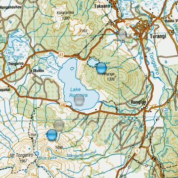
Interesting straight line string of quakes from Lake Taupo through to Mt Tongariro, central NI, NZ. 16th Apr.UTC

all very small, M0.71 - M1.57
might be the start of another swarm there, been a few in the past.
interactive NZTopo map for those who are not logged in and can't see the link for NZ in my signature.

all very small, M0.71 - M1.57
might be the start of another swarm there, been a few in the past.
interactive NZTopo map for those who are not logged in and can't see the link for NZ in my signature.
edit on 04u10610615 by muzzy because: (no reason given)
M 6.8 - 140km SSW of Sigave, Wallis and Futuna
1
Time
2015-04-17 10:52:57 UTC-05:00
Location
15.500°S 178.600°W
Depth
50.0 km
1
Time
2015-04-17 10:52:57 UTC-05:00
Location
15.500°S 178.600°W
Depth
50.0 km
a reply to: berkeleygal
eh??
that must be sourced from USelessGS surely
F-E Region: Fiji Islands Region
Time: 2015-04-17 15:52:54.3 UTC
Magnitude: 6.5 (Mw)
Epicenter: 178.51°W 16.05°S
Depth: 10 km
Status: C - confirmed
geofon.gfz-potsdam.de...
2015-04-17 15:52:52
West of Tonga Islands
latitude -16.02, longitude -178.72 , depth 10 km
Ms 6.3/27, mb 6.0/16
stations 38
GSRAS map
Its actually closer to Vanua Levu Is. in Fiji, by 41km, so why the reference to Wallis and Futuna?
its in the Fiji Islands F_E Region
earthquake.usgs.gov...
edit on 0400000010610615 by muzzy because: (no reason given)
a reply to: muzzy
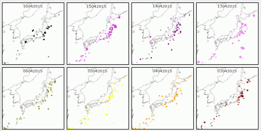
Was a good idea but was not too clear what was showing, the X axis need to be higher, but the thumbnail size is too small, so flagged it.
Gone back to the SVG outline map with dots according to magnitude, had them all red for a day, then thought it was a bit bland, alternating colours now to brighten the page up

Japan Maps
Was a good idea but was not too clear what was showing, the X axis need to be higher, but the thumbnail size is too small, so flagged it.
Gone back to the SVG outline map with dots according to magnitude, had them all red for a day, then thought it was a bit bland, alternating colours now to brighten the page up

Japan Maps
a reply to: muzzy
update on that 6.1 ML 14km SW Kasos, Crete
ikiBingmap (replaces that earlier one)
summary so far
mag2= 26 , mag3= 31 , mag4= 11 mag5= 1 , mag6= 1 , total= 70 total energy released= 24,143.295 TTNT
update on that 6.1 ML 14km SW Kasos, Crete
ikiBingmap (replaces that earlier one)
summary so far
mag2= 26 , mag3= 31 , mag4= 11 mag5= 1 , mag6= 1 , total= 70 total energy released= 24,143.295 TTNT
M6.8 - 78km SW of Yonakuni, Japan
earthquake.usgs.gov...
Time
2015-04-20 01:42:56 (UTC)
2015-04-19 18:42:56 (UTC-07:00) in your timezone
Times in other timezones
Nearby Cities
78km (48mi) SW of Yonakuni, Japan
91km (57mi) E of Hualian, Taiwan
99km (62mi) SE of Su'ao, Taiwan
118km (73mi) SE of Yilan, Taiwan
873km (542mi) ENE of Hong Kong, Hong Kong
a reply to: dreamfox1
I saw that just now, that's pretty big.
They knew something was on the way too, this is kinda scary.
According to the link, no tsunami warning. More to come?
I saw that just now, that's pretty big.
They knew something was on the way too, this is kinda scary.
sanfrancisco.cbslocal.com...
According to the link, no tsunami warning. More to come?
edit on 19-4-2015 by GoShredAK because: (no reason given)
edit on
19-4-2015 by GoShredAK because: (no reason given)
M 6.4 - 66km SE of Su'ao, Taiwan
Time
2015-04-19 20:42:58 UTC-05:00
Location
24.194°N 122.327°E
Depth
29.0 km
Current date and time is: Apr 20, 2015 02:53 UTC
No Tsunami Warnings, Advisories or Watches are in effect
Tsunami Alerts issued by NWS in the past 7 days
Apr 20, 2015 01:53 Alaska/BC/US West Coast Public Information 6.6
Apr 20, 2015 01:52 Hawaii Information 6.8
Apr 20, 2015 01:51 Pacific Ocean Information 6.6
a reply to: muzzy
Sorry, they, as in people in Japan, specifically due to the whales beaching themselves.
Also the people predicting earthquakes lately could be called "they".
Sorry, they, as in people in Japan, specifically due to the whales beaching themselves.
www.abovetopsecret.com...
Also the people predicting earthquakes lately could be called "they".
a reply to: GoShredAK
Oh yeah i forgot about "them"
5.0ML aftershock same spot as the 6.3
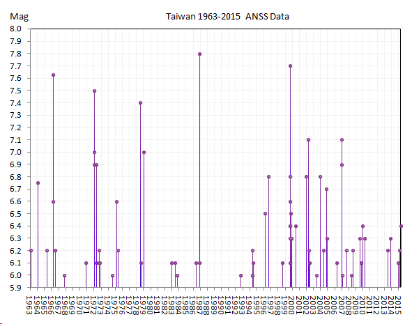
one of many, ANSS show 71 above 6.0 since 1963
interactive ikiBing map
historical chart, todays is the last dot

Oh yeah i forgot about "them"
5.0ML aftershock same spot as the 6.3
edit on 0400000010810815 by muzzy because: (no reason given)
one of many, ANSS show 71 above 6.0 since 1963
interactive ikiBing map
historical chart, todays is the last dot

edit on 0400000010910915 by muzzy because: (no reason given)
M6.0 - 160km WSW of Kuripan, Indonesia
Time
2015-04-20 09:05:31 (UTC)
2015-04-20 04:05:31 (UTC-05:00) in your timezone
Nearby Cities
160km (99mi) WSW of Kuripan, Indonesia
208km (129mi) SSW of Pagaralam, Indonesia
215km (134mi) S of Bengkulu, Indonesia
243km (151mi) SSW of Lahat, Indonesia
485km (301mi) W of Jakarta, Indonesia
USGS
edit on 20-4-2015 by lurksoften because: (no reason
given)
Something odd going on with USGS quake magnitudes. They are getting further away from EMSC - 5 to 2 at this time
Mm, they are different but it looks as it the EMSC download failed on the 18th and has stayed failed. I will not be able to repair it until tomorrow now.
ETA: I think this error is only in the development version. If some one running QVSData or QVSData Pro could check that EMSC is working OK I would appreciate it. Thanks.
Prov,Date/Time UTC,Latitude,Longitude,Magnitude,Depth(Km),Location
usgs,2015-04-20 11:45:14, 24.067, 122.460, 6.2, 35.6, Taiwan Region (243)
usgs,2015-04-20 09:05:31, -5.732, 102.489, 6.0, 10.0, Sthn Sumatra. Ind. (274)
usgs,2015-04-20 01:42:58, 24.193, 122.326, 6.4, 29.0, Taiwan Region (243)
emsc,2015-04-17 15:52:53, -16.110, -178.390, 6.5, 10.0, Fiji Region
usgs,2015-04-17 15:52:51, -15.907, -178.584, 6.5, 10.0, Fiji Isls. Region (181)
emsc,2015-04-16 18:07:44, 35.030, 26.810, 6.1, 30.0, Crete. Greece
usgs,2015-04-16 18:07:42, 35.136, 26.821, 6.0, 20.0, Crete. Greece (370)
Mm, they are different but it looks as it the EMSC download failed on the 18th and has stayed failed. I will not be able to repair it until tomorrow now.
edit on 20/4/2015 by PuterMan because: more information
ETA: I think this error is only in the development version. If some one running QVSData or QVSData Pro could check that EMSC is working OK I would appreciate it. Thanks.
edit on 20/4/2015 by PuterMan because: (no reason given)
USGS
M 6.2 - 70km SW of Yonakuni, Japan
DYFI? - IIIShakeMap - IVPAGER - GREEN
Time2015-04-20 11:45:14
UTCLocation24.068°N 122.460°E
Depth35.6 km
Edit: Just had another one 6.5
M 6.5 - 67km SW of Yonakuni, Japan
DYFI? - IVShakeMap - IVPAGER - GREEN
Time2015-04-20 12:00:01
UTCLocation24.052°N 122.514°E
Depth38.7 km
Couple other links for these quakes:
Japan Earthquake Track earthquaketrack.com...
Central Weather Bureau www.cwb.gov.tw...
M 6.2 - 70km SW of Yonakuni, Japan
DYFI? - IIIShakeMap - IVPAGER - GREEN
Time2015-04-20 11:45:14
UTCLocation24.068°N 122.460°E
Depth35.6 km
Edit: Just had another one 6.5
M 6.5 - 67km SW of Yonakuni, Japan
DYFI? - IVShakeMap - IVPAGER - GREEN
Time2015-04-20 12:00:01
UTCLocation24.052°N 122.514°E
Depth38.7 km
edit on 20-4-2015 by SeekingDepth because: (no reason given)
Couple other links for these quakes:
Japan Earthquake Track earthquaketrack.com...
Central Weather Bureau www.cwb.gov.tw...
edit on 20-4-2015 by SeekingDepth because: (no reason
given)
new topics
-
Covid Jab and the Alien Invasion
ATS Skunk Works: 4 hours ago -
Quantum Computer’s, Plasmoid’s, & UAP’s
Aliens and UFOs: 4 hours ago -
Political Warfare & The Resister Special Forces Underground
Political Ideology: 7 hours ago -
Trump Cancel trip to New Jersey because of drones
Aliens and UFOs: 7 hours ago
top topics
-
Is this really what is going on?
General Conspiracies: 16 hours ago, 10 flags -
School shooting in Madison Wi.
Social Issues and Civil Unrest: 12 hours ago, 10 flags -
Prisoner CNN helped free from Syrian prison was actually notorious Assad regime torturer: report
Mainstream News: 14 hours ago, 9 flags -
Trump Cancel trip to New Jersey because of drones
Aliens and UFOs: 7 hours ago, 5 flags -
Political Warfare & The Resister Special Forces Underground
Political Ideology: 7 hours ago, 5 flags -
Russias War Against Religion in Ukraine
World War Three: 17 hours ago, 4 flags -
Labour Plotting to Postpone May's Council Elections ?
Regional Politics: 16 hours ago, 4 flags -
Covid Jab and the Alien Invasion
ATS Skunk Works: 4 hours ago, 4 flags -
Quantum Computer’s, Plasmoid’s, & UAP’s
Aliens and UFOs: 4 hours ago, 2 flags
active topics
-
Quantum Computer’s, Plasmoid’s, & UAP’s
Aliens and UFOs • 5 • : SteamyAmerican -
-@TH3WH17ERABB17- -Q- ---TIME TO SHOW THE WORLD--- -Part- --44--
Dissecting Disinformation • 3733 • : duncanagain -
Covid Jab and the Alien Invasion
ATS Skunk Works • 8 • : SteamyAmerican -
Trump Cancel trip to New Jersey because of drones
Aliens and UFOs • 19 • : SteamyAmerican -
School shooting in Madison Wi.
Social Issues and Civil Unrest • 42 • : RalagaNarHallas -
Rant. I am sick of people saying the police are revenue raising.
Rant • 14 • : inflaymes69 -
Drones everywhere in New Jersey ---and Elsewhere Master Thread
Aliens and UFOs • 196 • : nugget1 -
Remember These Attacks When President Trump 2.0 Retribution-Justice Commences.
2024 Elections • 106 • : Connector -
Something better
Dissecting Disinformation • 33 • : Xtrozero -
Is this really what is going on?
General Conspiracies • 42 • : rickymouse
