It looks like you're using an Ad Blocker.
Please white-list or disable AboveTopSecret.com in your ad-blocking tool.
Thank you.
Some features of ATS will be disabled while you continue to use an ad-blocker.
share:
I will try to post here more information about situation there so you can understand better how dangerous is situation there in time ahead ..
Can this EQ be more devastating and stronger of ~ M 7.7, think yes it is possible if you look carefully all possible information data from history of EQ's on San Andreas fault line, we did not have central-southern CA big EQ's in many last decades so have some possibility to rupture length be long from last one 1857 ..
The Fort Tejon earthquake of M 7.9 in 1857 was one of the greatest earthquakes ever recorded in the U.S., and left an amazing surface rupture scar over about 360 km (225 miles) kilometers in length along the San Andreas fault, with an average slip of 4.5 meters (15 feet) and a maximum displacement of about 9 meters (30 feet) ..
Some information what indicate also strong foreshocks for this "Big One" between one and nine hours before the main event around M 7.9, so again will say think this is best way to predict next "Big One" and warn people in advance ..
Most dangerous scenario for very catastrophic EQ is if rupture all area from San Francisco to Salton Sea in same time or in one big EQ-rupture but that's not necessarily, have many more scenario also hope this option will not happen and very big present pressure between these tectonic planets will be released in several EQ's around M 7.0 ..
All available info telling me and from what I know and feel there will be in 95% strong foreshock or foreshocks minutes or hours before "main even or rupture", so if you feel stronger EQ around M 6.2 + or stronger you can expect stronger to come because many many reasons and I don't have now time to put them all, also in high % all historical Big EQ's had a foreshocks I post only some of them in this thread ..
en.wikipedia.org...
articles.latimes.com...
Wrightwood's 1812 Earthquake
www.wrightwoodcalif.com...
The December 21, 1812 Santa Barbara Earthquake and Tsunami around M 7.3 ..
www.data.scec.org...
www.usc.edu...
"Wrightwood in 1812 (Mw = 7.5) and Fort. Tejon in 1857 (Mw = 8.2)"
www.eas.purdue.edu...

Can this EQ be more devastating and stronger of ~ M 7.7, think yes it is possible if you look carefully all possible information data from history of EQ's on San Andreas fault line, we did not have central-southern CA big EQ's in many last decades so have some possibility to rupture length be long from last one 1857 ..
The Fort Tejon earthquake of M 7.9 in 1857 was one of the greatest earthquakes ever recorded in the U.S., and left an amazing surface rupture scar over about 360 km (225 miles) kilometers in length along the San Andreas fault, with an average slip of 4.5 meters (15 feet) and a maximum displacement of about 9 meters (30 feet) ..
Some information what indicate also strong foreshocks for this "Big One" between one and nine hours before the main event around M 7.9, so again will say think this is best way to predict next "Big One" and warn people in advance ..
Most dangerous scenario for very catastrophic EQ is if rupture all area from San Francisco to Salton Sea in same time or in one big EQ-rupture but that's not necessarily, have many more scenario also hope this option will not happen and very big present pressure between these tectonic planets will be released in several EQ's around M 7.0 ..
All available info telling me and from what I know and feel there will be in 95% strong foreshock or foreshocks minutes or hours before "main even or rupture", so if you feel stronger EQ around M 6.2 + or stronger you can expect stronger to come because many many reasons and I don't have now time to put them all, also in high % all historical Big EQ's had a foreshocks I post only some of them in this thread ..
en.wikipedia.org...
The last Big One ripped through Southern California in 1857, when an estimated magnitude 7.9 quake ruptured 200 miles of fault between Monterey and San Bernardino counties. But it wasn't a wall-to-wall quake: It stopped around the Cajon Pass, near the present-day 15 Freeway, probably because the fault south of that area had shaken just a few decades earlier, in 1812, Jones said. Because the 1812 quake had relieved tectonic tension in the Cajon Pass, it effectively stopped the 1857 quake from moving farther south.
"Can I imagine the 1857 earthquake happening again and stopping at the Cajon Pass? Probably not," Jones said. "Once you have a big slip, you're more likely to move along down the fault," she said. "If the rupture has been made ... that's a lot of momentum that will keep the rupture moving down the fault."
A magnitude 8.1 wall-to-wall quake would release twice the energy of the 1857 temblor, Jordan said.
articles.latimes.com...
Wrightwood's 1812 Earthquake
On December 8, 1812, a powerful earthquake registering +7.0 occurred on the Mojave segment of the San Andreas fault.
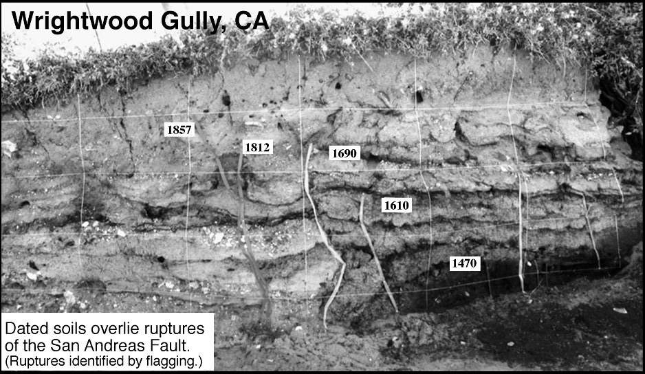
Radiocarbon dating of the peat-layers revealed the ages of the sediments and therefore the approximate ages of the earthquakes that caused the fault ruptures. The geologist's data showed at least 5 very strong (M+7?) earthquakes had during the past 500 years with the approximate ages of: 1857, 1812, 1690, 1610, and 1470.The key to sequence are the 1857 and 1812 earthquakes, the last major earthquakes along the southern San Andreas fault during historic time!
The data suggests average time between very strong events is 97 years, with the greatest being 140 years and the shortest in just 45 years. Disturbingly, it has been 140 years since this segment last ruptured!
www.wrightwoodcalif.com...
The December 21, 1812 Santa Barbara Earthquake and Tsunami around M 7.3 ..
Another damaging earthquake occurred in southern California in the month of December, 1812, potentially triggered by the Wrightwood quake two weeks earlier that month. The epicenter of this one, too, is of uncertain location.
Because of the widespread damage it caused, it was probably as large as magnitude 7. It is probable that the epicenter was located offshore, possibly in the Santa Barbara channel, but an inland epicenter, somewhere in present-day Santa Barbara County, or even Ventura County, cannot be ruled out.
www.data.scec.org...
www.usc.edu...
"Wrightwood in 1812 (Mw = 7.5) and Fort. Tejon in 1857 (Mw = 8.2)"
www.eas.purdue.edu...


edit on 23-3-2013 by MariaLida because: (no reason given)
reply to post by MariaLida
Do you think the one in 1812 had anything to do with the New madrid fault? Do you think if one goes the other will?
The states seem to be very active lately and I am wondering if its because of fracking or what??
Do you think the one in 1812 had anything to do with the New madrid fault? Do you think if one goes the other will?
The states seem to be very active lately and I am wondering if its because of fracking or what??
Originally posted by MamaJ
reply to post by MariaLida
Do you think the one in 1812 had anything to do with the New madrid fault? Do you think if one goes the other will?
The states seem to be very active lately and I am wondering if its because of fracking or what??
Good day mo0m
I'm not worry about that area too much, my main concern is West Coast of N America ..
It's very complicated to explain but all stronger eartquekes effect in some way EQ's and seizmic situation worldwide especially if they are on same tectonic plate etc etc ..
Important is how much time will pass to have effect or stronger EQ's and how you calculate that and what kind of effect have, have many different effects, different location, plate, ocean-land, time, external effect, internal pressure, configuration fault line and many more, pressure is present all time between some tectonic plates worldwide ..
Yes this New Madrid earthquakes 1811–1812 probably effect some stronger activity on West Coast fault line, December 8 1812 Wrightwood ~ M 7.5, December 21 1812 Santa Barbara around ~ M 7.1 ..
edit on 23-3-2013 by MariaLida because: (no reason given)
reply to post by MariaLida
Maria, thanks for keeping on this, I wish I could studie this stuff all day.
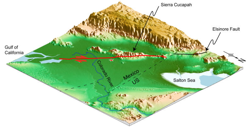
I'm here in north San Diego, and was investigating the Eq threat around SD. Just north and east of us runs the Elsinore fault, capable of a 7+ EQ.
The Elsinore fault extends into the Laguna Salada Fault, this runs south behind SanDiego into Baja California. The 2010 Baja quake was thought to originate on this fault.
I know the San Andreas is the focus here, but could one of these off shoot faults like the Elsinore and Laguna Salada be in the mix for the next big one? Or perhaps generate a foreshock, triggering the larger San Andreas Fault?
If you want to scare yourself and you live in San Diego read this, it talks about the possibilities of a major EQ on the Elsinore fault. Quake would be county's Katrina; Elsinore fault said more dangerous locally than San Andreas
I'm here in north San Diego, and was investigating the Eq threat around SD. Just north and east of us runs the Elsinore fault, capable of a 7+ EQ.
The Elsinore Fault Zone is a large right-lateral strike-slip geological fault structure in Southern California. The fault is part of the trilateral split of the San Andreas fault system and is one of the largest, though quietest faults in Southern California
It is estimated that this zone is capable of producing a quake of 6.5–7.5 Elsinore Fault Zonei
The Elsinore fault extends into the Laguna Salada Fault, this runs south behind SanDiego into Baja California. The 2010 Baja quake was thought to originate on this fault.
The Laguna Salada Fault is a probable southern continuation of the Elsinore Fault Zone in Southern California.[4] These faults are considered to be secondary cohorts of the San Andreas Fault, and as such share some of the strike-slip motion between the North American Plate and the Pacific Plate. Laguna Salada Fault
I know the San Andreas is the focus here, but could one of these off shoot faults like the Elsinore and Laguna Salada be in the mix for the next big one? Or perhaps generate a foreshock, triggering the larger San Andreas Fault?
If you want to scare yourself and you live in San Diego read this, it talks about the possibilities of a major EQ on the Elsinore fault. Quake would be county's Katrina; Elsinore fault said more dangerous locally than San Andreas
edit on 23-3-2013 by Observationalist because: (no reason given)
reply to post by Observationalist
Thank you for info ..
Yes of course it is possible all stronger EQ on any faults in SoCal can make San A. to slip witch is under big pressure, we have many faults there and is very complicate also new faults forming ..
Think any stronger EQ's on all faults in SoCal can be foreshock (especially M 6.2+) to San Andreas rupture in "Big One", also EQ's on faults from Golf of California to Salton Sea ..
This thread is all about that and very possible stronger foreshock or foreshocks, all faults are very connected more then you think in this area but stronger shake can lead to main rupture and that's very useful to know in advance minutes or hours probably 12 hrs max ..
www.futurity.org...
img.abovetopsecret.com...
Thank you for info ..
Yes of course it is possible all stronger EQ on any faults in SoCal can make San A. to slip witch is under big pressure, we have many faults there and is very complicate also new faults forming ..
Think any stronger EQ's on all faults in SoCal can be foreshock (especially M 6.2+) to San Andreas rupture in "Big One", also EQ's on faults from Golf of California to Salton Sea ..
This thread is all about that and very possible stronger foreshock or foreshocks, all faults are very connected more then you think in this area but stronger shake can lead to main rupture and that's very useful to know in advance minutes or hours probably 12 hrs max ..

www.futurity.org...

img.abovetopsecret.com...
edit on 23-3-2013 by MariaLida because: (no reason given)
reply to post by MariaLida
Thank you for the information and taking time to respond. Much appreciated. Again, we see the states active in and around the west. Oregon is on board this morning.
Anytime Vanuatu shows up it seems there is a bigger EQ. Have you notice that or am I just seeing into things and being paranoid. lol
Thank you for the information and taking time to respond. Much appreciated. Again, we see the states active in and around the west. Oregon is on board this morning.
Anytime Vanuatu shows up it seems there is a bigger EQ. Have you notice that or am I just seeing into things and being paranoid. lol
Originally posted by MamaJ
reply to post by MariaLida
Thank you for the information and taking time to respond. Much appreciated. Again, we see the states active in and around the west. Oregon is on board this morning.
Anytime Vanuatu shows up it seems there is a bigger EQ. Have you notice that or am I just seeing into things and being paranoid. lol
Ciao dear mo0m hope you are ok also you family, I know you are very interested in present and situation ahead ..
Ok I will post some dangerous days for strong seizmic activity for rest of 2013, that days can effect San Andreas fault to rupture in very strong EQ ..
Also dangerous location from Japan - China - Turkey - Italy to have very strong EQ's with many casualties ..
Next days to end of April (next 35 days) and days from 16 to 23 June, also we will have super full moon for this year on 23 June ..
Perigee - Jun 23 11:11 356989 km ++ F- 0h
Full moon - 2013 Jun 23 11:34
I expect at sensitive area very strong EQ of M 8.0 + from 16 to 23 June, for next 35 days we have several very dangerous days so I will post danger for all 35 days and we probably will have very strong seizmic activity worldwide and probably EQ of M 7.5 + ..
I could post more precisely and know "that days" but think this way is better because many many reasons, also could also post 2-3 days in advance but one of the reasons is that many use my predictions in 2012 and overwrite itself mostly because some small money from donate or you-tube, there was more of 20 accurate prediction of M 7.0 + in 3-4 days advance and only 1-2 miss ..
Don't get me wrong mo0m but I'm very tired of that because I lose all year for monitoring only EQ's prediction and neglected all my personal obligations so you know how I feel, let see what "they" really know and when someone predict accurate EQ of M 7.0 in 3-4 days advance or similar, in last 3 months see only failures from them and already know what is to follow,
Second reason is that I don't have free time anymore to monitoring non-stop all possible signs for strong EQ's and calculate them, third reason EQ's can't be precisely predicted in 3 days for one year in advance can only if I or you "see" signs in 3 days earlier but only when I monitoring non-stop all possible what I have etc ..
Peace ..
And if nothing come stronger on San Andreas fault to June, I will advise you to take much attention around this days from 16 to 24 June 2013 and of course always for strong very possible foreshocks of M 6.0+ for California area also very probably foreshock will be on faults around Los Angeles from Parkfield to Salton Sea ..
edit on 24-3-2013 by MariaLida because: (no reason given)
reply to post by MariaLida
Terremoti Italia dal 1900
24 Marzo 2013
www.fondazionegiuliani.it...
Here you can see some earthquake history for Italy ..
Possibility for M 6.0 + in dangerous time posted above in Italy, Turkey China also very dangerous areas ..
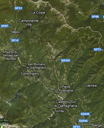
Some possible location for next strong EQ in Italy ..
www.abovetopsecret.com...
Terremoti Italia dal 1900
24 Marzo 2013
www.fondazionegiuliani.it...
Here you can see some earthquake history for Italy ..
Possibility for M 6.0 + in dangerous time posted above in Italy, Turkey China also very dangerous areas ..
Some possible location for next strong EQ in Italy ..

www.abovetopsecret.com...
edit on 24-3-2013 by MariaLida because: (no reason given)
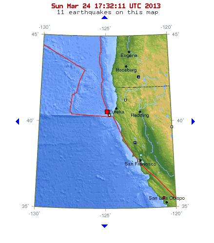
We just have one minor and very shallow EQ around Eureka offshore north side of San Andreas fault
2013-03-24 17:25:40.20 12 min ago 40.63 N 124.87 W 1 4.3 OFFSHORE NORTHERN CALIFORNIA
Magnitude 4.3
Date-Time
Sunday, March 24, 2013 at 17:25:40 UTC
Sunday, March 24, 2013 at 10:25:40 AM at epicenter
Location 40.628°N, 124.870°W
Depth 0.6 km (~0.4 mile) (poorly constrained)
Region OFFSHORE NORTHERN CALIFORNIA
Distances
52 km (32 miles) W (276°) from Ferndale, CA
57 km (36 miles) W (259°) from Humboldt Hill, CA
60 km (37 miles) NW (304°) from Petrolia, CA
62 km (39 miles) WSW (253°) from Eureka, CA
372 km (231 miles) NW (309°) from Sacramento, CA
earthquake.usgs.gov...
Also 2 min later very interesting and rare EQ, no history from EMSC for EQ's in this area ..
2013-03-24 17:28:23.014 min ago 11.91 N 60.02 W 30 4.8 TOBAGO REGION, TRINIDAD-TOBAGO
www.emsc-csem.org...
2013-03-24 17:25:40.20 12 min ago 40.63 N 124.87 W 1 4.3 OFFSHORE NORTHERN CALIFORNIA
Magnitude 4.3
Date-Time
Sunday, March 24, 2013 at 17:25:40 UTC
Sunday, March 24, 2013 at 10:25:40 AM at epicenter
Location 40.628°N, 124.870°W
Depth 0.6 km (~0.4 mile) (poorly constrained)
Region OFFSHORE NORTHERN CALIFORNIA
Distances
52 km (32 miles) W (276°) from Ferndale, CA
57 km (36 miles) W (259°) from Humboldt Hill, CA
60 km (37 miles) NW (304°) from Petrolia, CA
62 km (39 miles) WSW (253°) from Eureka, CA
372 km (231 miles) NW (309°) from Sacramento, CA
earthquake.usgs.gov...

Also 2 min later very interesting and rare EQ, no history from EMSC for EQ's in this area ..
2013-03-24 17:28:23.014 min ago 11.91 N 60.02 W 30 4.8 TOBAGO REGION, TRINIDAD-TOBAGO
www.emsc-csem.org...
edit on 24-3-2013 by MariaLida because: (no reason given)
reply to post by MariaLida
Thank you again for all your insight!! I love it and I do understand how time is limited. I have three kids playing hockey and one in baseball too. Im worn out! lol
The EQ off shore Cali, Oregon, Vanuatu, Italy, and this one below has me interested today, to see if anything else unfolds.
This one below, I have never seen quake.
Also 2 min later very interesting and rare EQ, no history from EMSC for EQ's in this area .. 2013-03-24 17:28:23.014 min ago 11.91 N 60.02 W 30 4.8 TOBAGO REGION, TRINIDAD-TOBAGO
reply to post by MamaJ
I wouldn't exactly call it rare as your quote source says, the USGS area history for it shows a litany of them since 1990:
USGS historical seismicity
I will say it did take me by surprise, though. They certainly don't seem as common as elsewhere. I remember there was a 5 on the east side of the boundary not too long ago and was really surprised. I thought it was maybe a rare one until I looked at the area history page.
edit on
3/24/2013 by Nyiah because: Fixed link
reply to post by Nyiah
Thanks for the info! Appreciate it. Maybe the LHC is no longer smashing atoms. JK, JK
Thanks for the info! Appreciate it. Maybe the LHC is no longer smashing atoms. JK, JK
reply to post by MariaLida
1964 Alaska Earthquake and Tsunami Anniversary
March 26, 2013
kxro.wordpress.com...
27 March 1964 (5:36 P.M) Good Friday Earthquake Magnitude: The Surface-wave magnitude calculated in 1964, was 8.4 on the Richter scale. The Moment Magnitude calculated later was 9.2 ..
Are you Ready for the Next Big Quake, pdf 7.5 mb ..
www.ak-prepared.com...
Earthquake in Alaska ..
geopubs.wr.usgs.gov...
www2.borough.kenai.ak.us...
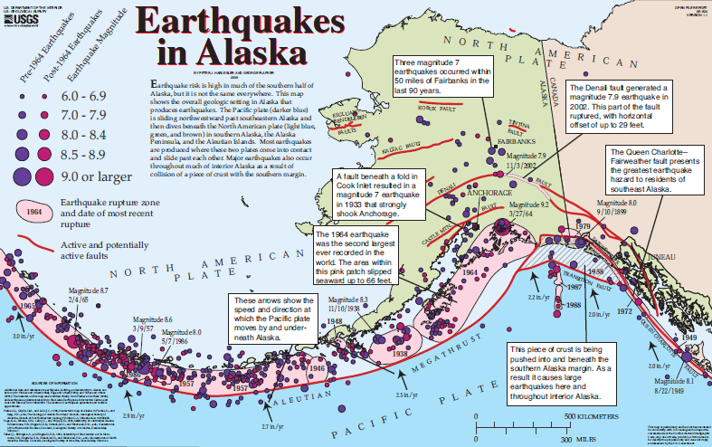
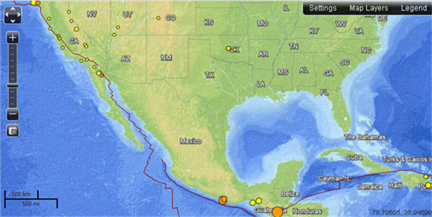
We had also two interesting EQ's ..
www.emsc-csem.org...
2013-03-26 13:04:49.0 3hr 34min ago 16.22 N 98.22 W 10 5.5 OFFSHORE OAXACA, MEXICO
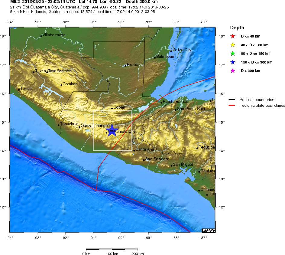
2013-03-25 23:02:14.0 14.70 N 90.32 W 200 6.2 GUATEMALA
1964 Alaska Earthquake and Tsunami Anniversary
March 26, 2013
Wednesday will mark the anniversary of the 1964 Alaska earthquake that generated the largest and best-recorded historical tsunami on the southern Washington coast.
Coinciding with the anniversary, March 24-30 is Tsunami Preparedness Week.
According to Deputy Director of Emergency Management Chuck Wallace, the entire Washington coast is susceptible to tsunami and there is much evidence of numerous large tsunami events that impacted our coastal counties.
Residents are asked to learn the risks they face at home and at work. Family preparedness will help reduce the impact any significant severe disaster will have upon all members of your family.
kxro.wordpress.com...
27 March 1964 (5:36 P.M) Good Friday Earthquake Magnitude: The Surface-wave magnitude calculated in 1964, was 8.4 on the Richter scale. The Moment Magnitude calculated later was 9.2 ..
Are you Ready for the Next Big Quake, pdf 7.5 mb ..
www.ak-prepared.com...
Earthquake in Alaska ..
geopubs.wr.usgs.gov...
www2.borough.kenai.ak.us...

We had also two interesting EQ's ..
www.emsc-csem.org...
2013-03-26 13:04:49.0 3hr 34min ago 16.22 N 98.22 W 10 5.5 OFFSHORE OAXACA, MEXICO
2013-03-25 23:02:14.0 14.70 N 90.32 W 200 6.2 GUATEMALA

edit on 26-3-2013 by MariaLida because: (no reason given)
reply to post by MariaLida
I Love this map, thanks.
Interesting faults off shore of San Diego, they too don't move very much.

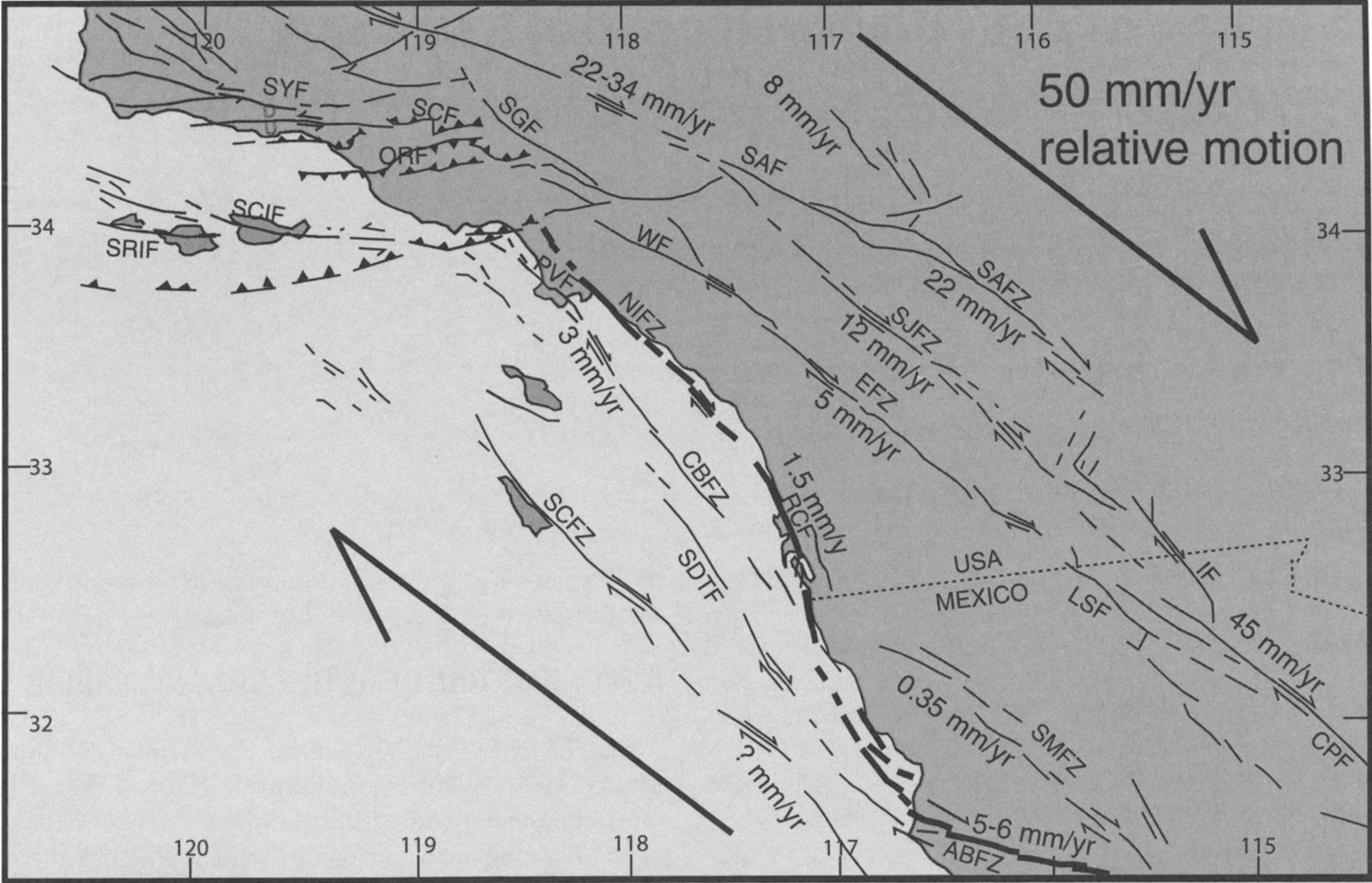
The relative motion for all the faults indicate they are strike slip, is that correct? could some be dip-slip?
Sorry if I'm a little behind here, im just trying to learn as I go.
A little research on the Elsinore fault showed that there is evidence of dip-slip which could account for its lack of movement.
Could the Elsinor or these other off shoot fault be a risk of a blind thrust fault. I know Northridge EQ came from an undiscovered blind thrust fault.
found this article that support my concern.
Hidden Quake Risks Cited for O.C.
I Love this map, thanks.
Interesting faults off shore of San Diego, they too don't move very much.

The relative motion for all the faults indicate they are strike slip, is that correct? could some be dip-slip?
Sorry if I'm a little behind here, im just trying to learn as I go.
A little research on the Elsinore fault showed that there is evidence of dip-slip which could account for its lack of movement.
Could the Elsinor or these other off shoot fault be a risk of a blind thrust fault. I know Northridge EQ came from an undiscovered blind thrust fault.
found this article that support my concern.
Hidden Quake Risks Cited for O.C.
Blind thrust faults may trigger high-magnitude quakes in known risk zones, including the Newport-Inglewood fault, UCI geologists say.
edit on 26-3-2013 by Observationalist because: Trying to fix image
edit on 26-3-2013 by Observationalist because: Got
it
edit on 26-3-2013 by Observationalist because: (no reason given)
reply to post by MariaLida
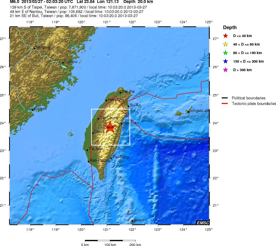
After 6.2-Magnitude what hits near capital Guatemala City we had on similar dangerous latitude one more strong EQ in TAIWAN ..
www.youtube.com... ; www.youtube.com...
2013-03-27 02:03:20.0 23.84 N 121.13 E 21 6.1 TAIWAN
2013-03-25 23:02:14.0 14.70 N 90.32 W 200 6.2 GUATEMALA
Powerful Oklahoma quake was caused by oil-drilling procedure, man-made scientists say!
Originally posted by MariaLida"Ok I will post some dangerous days for strong seizmic activity for rest of 2013, that days can effect San Andreas fault to rupture in very strong EQ .."
"Also dangerous location from Japan - China - Turkey - Italy to have very strong EQ's with many casualties .."
"Next days to end of April (next 35 days) and days from 16 to 23 June, also we will have super full moon for this year on 23 June .. "
"I expect at sensitive area very strong EQ of M 8.0 + from 16 to 23 June, for next 35 days we have several very dangerous days so I will post danger for all 35 days and we probably will have very strong seizmic activity worldwide and probably EQ of M 7.5 + .."
After 6.2-Magnitude what hits near capital Guatemala City we had on similar dangerous latitude one more strong EQ in TAIWAN ..
www.youtube.com... ; www.youtube.com...
2013-03-27 02:03:20.0 23.84 N 121.13 E 21 6.1 TAIWAN
2013-03-25 23:02:14.0 14.70 N 90.32 W 200 6.2 GUATEMALA


Powerful Oklahoma quake was caused by oil-drilling procedure, man-made scientists say!
edit on 27-3-2013 by MariaLida because: (no reason given)
reply to post by MariaLida
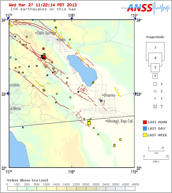
Again we have some activity in SoCal same area like last one of M 5.2 ..
MAP 3.3 2013/03/27 18:17:44 33.493 -116.439 9.0 SOUTHERN CALIFORNIA
MAP 3.7 2013/03/27 18:17:00 33.490 -116.447 3.9 SOUTHERN CALIFORNIA
MAP 3.4 2013/03/27 17:50:29 33.491 -116.446 4.5 SOUTHERN CALIFORNIA
Magnitude 3.7
Date-Time
Wednesday, March 27, 2013 at 18:17:00 UTC
Wednesday, March 27, 2013 at 11:17:00 AM at epicenter
Location 33.490°N, 116.447°W
Depth 3.9 km (2.4 miles)
Region SOUTHERN CALIFORNIA
Distances
22 km (14 miles) ESE (109°) from Anza, CA
25 km (15 miles) SW (214°) from La Quinta, CA
27 km (17 miles) SSW (195°) from Palm Desert, CA
38 km (24 miles) SSE (168°) from Palm Springs, CA
102 km (64 miles) NE (39°) from San Diego, CA
earthquake.usgs.gov...

edit on 27-3-2013 by MariaLida because: (no reason given)
reply to post by MariaLida
Forgive me if I'm distracting here, but Google is a dangerous tool
I found an article with a seismologist, Tom Rockwell answering questions about the frequency of EQs on the San Jaquinto Fault, which is where I belive this recent activity is on.
Should we worry about shaking on San Jacinto fault?
This was back in 2011 when there was some activity.
He talks about the San Andreas and potential for the Big One too.
Forgive me if I'm distracting here, but Google is a dangerous tool
I found an article with a seismologist, Tom Rockwell answering questions about the frequency of EQs on the San Jaquinto Fault, which is where I belive this recent activity is on.
Should we worry about shaking on San Jacinto fault?
This was back in 2011 when there was some activity.
A: The San Jacinto fault commonly has a fairly significant level of micro-seismicity, so this is not unusual. This activity will grab my attention if it is followed by a moderate earthquake in the magnitude 5 range, which could be leading to a larger earthquake. As always, it is good to be prepared, just in case.
He talks about the San Andreas and potential for the Big One too.
To expand a bit on this. The southern San Andreas fault last ruptured in a great earthquake about 300 years ago, and has an average recurrence interval for the past 1400 years of about 200 years - hence, the reason scientists keep on expecting a large earthquake on the San Andreas. In comparison, the large San Jacinto earthquakes that fall in the 7.3-7.5 range occur every 200-250 years, and the last one was in November, 1800.
California is very active today..... I wonder what will happen next? Anything?
reply to post by MariaLida
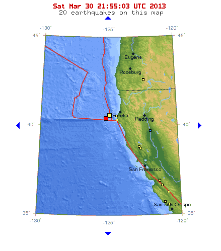
2013-03-30 21:43:19.0 18min ago 40.54 N 126.21 W 10 4.7 OFF COAST OF NORTHERN CALIFORNIA
GFZ say M 5.1 ..
Magnitude 4.7
Date-Time
Saturday, March 30, 2013 at 21:43:28 UTC
Saturday, March 30, 2013 at 02:43:28 PM at epicenter
Location 40.453°N, 125.233°W
Depth 4.8 km (3.0 miles) (poorly constrained)
Region OFFSHORE NORTHERN CALIFORNIA
Distances
81 km (51 miles) W (280°) from Petrolia, CA
83 km (52 miles) W (261°) from Ferndale, CA
92 km (57 miles) WSW (251°) from Humboldt Hill, CA
98 km (61 miles) WSW (248°) from Eureka, CA
384 km (239 miles) NW (322°) from San Francisco City Hall, CA
earthquake.usgs.gov...

edit on 30-3-2013 by MariaLida because: (no reason given)
reply to post by MariaLida
It's M 5.1, now on USGS also ..
Magnitude5.1
Date-Time
Saturday, March 30, 2013 at 21:43:19 UTC
Saturday, March 30, 2013 at 01:43:19 PM at epicenter
Location 40.467°N, 126.153°W
Depth 10.1 km (6.3 miles)
Region OFF THE COAST OF NORTHERN CALIFORNIA
Distances
159 km (99 miles) W (276°) from Petrolia, CA
160 km (100 miles) W (266°) from Ferndale, CA
167 km (104 miles) W (260°) from Humboldt Hill, CA
172 km (107 miles) W (259°) from Eureka, CA
440 km (273 miles) NW (314°) from San Francisco City Hall, CA
earthquake.usgs.gov...
new topics
-
Smartest Man in the World Tells His Theory About What Happens At Death
Philosophy and Metaphysics: 52 minutes ago -
Covid....... Again.
Diseases and Pandemics: 3 hours ago -
US Federal Funding set to Expire December 20th. Massive CR on the way.
Mainstream News: 3 hours ago -
and14263 New Account Not the Same Old Me
Introductions: 4 hours ago -
Just spotted an unusual aircraft Melbourne Australia
Aliens and UFOs: 11 hours ago
top topics
-
US Federal Funding set to Expire December 20th. Massive CR on the way.
Mainstream News: 3 hours ago, 7 flags -
Covid....... Again.
Diseases and Pandemics: 3 hours ago, 7 flags -
The truth lets admit it
Aliens and UFOs: 17 hours ago, 6 flags -
Just spotted an unusual aircraft Melbourne Australia
Aliens and UFOs: 11 hours ago, 6 flags -
Smartest Man in the World Tells His Theory About What Happens At Death
Philosophy and Metaphysics: 52 minutes ago, 4 flags -
and14263 New Account Not the Same Old Me
Introductions: 4 hours ago, 2 flags
active topics
-
Smartest Man in the World Tells His Theory About What Happens At Death
Philosophy and Metaphysics • 5 • : BeyondKnowledge3 -
Covid....... Again.
Diseases and Pandemics • 14 • : tinkerbell99 -
Just spotted an unusual aircraft Melbourne Australia
Aliens and UFOs • 4 • : JadedGhost -
Lowrider Car Show
Automotive Discussion • 18 • : Naftalin -
and14263 New Account Not the Same Old Me
Introductions • 8 • : DontTreadOnMe -
Mood Music Part VI
Music • 3742 • : angelchemuel -
The truth lets admit it
Aliens and UFOs • 51 • : introufo2 -
US Federal Funding set to Expire December 20th. Massive CR on the way.
Mainstream News • 8 • : WeMustCare -
Trump Cancel trip to New Jersey because of drones
Aliens and UFOs • 71 • : Tolkien -
Defending the need for adherence to Old Testament commandments under the new covenant of Christ
Conspiracies in Religions • 49 • : Oldcarpy2
