It looks like you're using an Ad Blocker.
Please white-list or disable AboveTopSecret.com in your ad-blocking tool.
Thank you.
Some features of ATS will be disabled while you continue to use an ad-blocker.
share:
reply to post by kdog1982
I live about 20 miles north of Birmingham. We are always in the path of bad storms when they come through. Make no mistake, I am always hyper-vigilant to coming storms. Thanks for the pre warning though.
I live about 20 miles north of Birmingham. We are always in the path of bad storms when they come through. Make no mistake, I am always hyper-vigilant to coming storms. Thanks for the pre warning though.
Originally posted by Lichter daraus
reply to post by elevatedone
So are replying as a mod or a member, i dont see that neat line around your post stating that your replying as a member.
Anyway on topic. Sure looks like it could get messy for anyone in the area, man i wish i was there.
Stay safe peeps.
Peace
I agree with you there . . . it is weather. But it is odd weather.
These kinds of swings in weather such as many of us are having indicate the annual battle between winter and spring . . . colliding air masses of cold and warm causing these storms.
The thing is, they are happening earlier and earlier each year. This is April weather.
Which makes it odd for the end of January.
Any news if its going to hit Maryland? Or will it be too far south?
reply to post by kdog1982
So the newest for the Chigaoland area is DENSE fog starting at some point in the next few hours and going until 3am (zero visibility fog), 2-3" of rain, flood warnings because soil is frozen 2" deep, so everything will just run right off. Anyhow, that is an awful lot of rain, and we're getting the sissy edge of the storm. Brace yourselves folks, and if there's a place to get dry ice around you, that's the cheapest, easiest way to keep your fridge food safe , if you don't have a generator.
So the newest for the Chigaoland area is DENSE fog starting at some point in the next few hours and going until 3am (zero visibility fog), 2-3" of rain, flood warnings because soil is frozen 2" deep, so everything will just run right off. Anyhow, that is an awful lot of rain, and we're getting the sissy edge of the storm. Brace yourselves folks, and if there's a place to get dry ice around you, that's the cheapest, easiest way to keep your fridge food safe , if you don't have a generator.
These kinds of threads are not only comfy places for me to visit and keep up with other people in the path of possible danger, I also get a faster
heads-up from people who are being affected in my surrounding areas. I know last year, I headed down to the basement during tornado warnings faster
than I would have, if not keeping track of the ones touching down around me, in a thread just like this one. Any form of pre-warning is a good thing
in my book.
But, most of all. I don't feel so damn all alone, in being scared of what I see, and hear, happening right outside my own door sometimes. Just hearing someone here, wish me well and safety, means a lot to this old Lady.
Des
But, most of all. I don't feel so damn all alone, in being scared of what I see, and hear, happening right outside my own door sometimes. Just hearing someone here, wish me well and safety, means a lot to this old Lady.
Des
edit on 28-1-2013 by Destinyone because: (no reason given)
Ahhh.....Des, I feel the same way. We shall hold hands over the Internet. (Did you bring the coffee? This thing is hitting around 1am Wed.
morning.)
For people in my area, I will try to give the best updates I can. It looks mostly like strong winds at this point for here. Hopefully it stays that way.
For people in my area, I will try to give the best updates I can. It looks mostly like strong winds at this point for here. Hopefully it stays that way.
reply to post by kdog1982
Appreciate the heads up! Seems this one will mostly miss us, but I have family in Tennessee and Texas, that could be affected. Here, I think we simply have more cold predicted. Should be interesting to watch the next few days, though.
Out of curiosity, anything major happen in Washington DC the last couple of days?
reply to post by Doodle19815
Coffee?
Where is the emergency supply of beer and liqueur?
The only fun thing with hurricanes was that you had alot of time to plan,and party.
With these damn storms,it's hit and miss like a random shooting.
Take care,ladies and keep me updated as I will do the same.
Peace,
K
Coffee?
Where is the emergency supply of beer and liqueur?
The only fun thing with hurricanes was that you had alot of time to plan,and party.
With these damn storms,it's hit and miss like a random shooting.
Take care,ladies and keep me updated as I will do the same.
Peace,
K
Originally posted by LadyGreenEyes
reply to post by kdog1982
Appreciate the heads up! Seems this one will mostly miss us, but I have family in Tennessee and Texas, that could be affected. Here, I think we simply have more cold predicted. Should be interesting to watch the next few days, though.
Out of curiosity, anything major happen in Washington DC the last couple of days?
Not that I know of.
Seems to be ok for the next few days.
This little storm will bring nothing but rain to the DC area by Thursday.
The latest for tonight in the midwest.
www.weather.com...
This pattern will be favorable for thunderstorms to produce damaging winds and possible tornadoes late Monday night through Tuesday and Wednesday in parts of the South, lower Midwest, and eventually the mid-Atlantic region. The threat begins between midnight Monday night and sunrise Tuesday, centered over parts of Oklahoma. The maps on this page show the latest timing forecast for these storms from The Weather Channel's Global Forecast Center.
www.weather.com...
reply to post by kdog1982
Thanx kdog. We have lake wind advisories right now for Texas but our local weatherman for Shreveport says we here in NW Louisiana can expect the inclement weather on Tuesday morning but more so toward afternoon with chances of high winds, hail, and possible tornadoes...especially east of Bossier City. The temps here today were 78 and the same is expected for tomorrow...78 in the day and the rest of the week 60's in day and 30's at nite. What weather for January.
Another local weatherman says the weather will arrive more toward afternoon..regardless, I'm going to be vigilant relevant to what all is occurring outside at any given time as we can get some really nasty storms around these parts.
Some folks think it is silly to be prepared or worried about the weather but I do not. We had a horrible Easter Day tornadoe here some years back...caught folks off guard. Deaths and injuries occurred...it was sad and terrible. We take these things seriously here. Thanx againn for the info and heads up. It is never a bad idea! ^j^
edit on 29-1-2013 by shrevegal because: spelling error
Originally posted by kdog1982
Originally posted by LadyGreenEyes
reply to post by kdog1982
Appreciate the heads up! Seems this one will mostly miss us, but I have family in Tennessee and Texas, that could be affected. Here, I think we simply have more cold predicted. Should be interesting to watch the next few days, though.
Out of curiosity, anything major happen in Washington DC the last couple of days?
Not that I know of.
Seems to be ok for the next few days.
This little storm will bring nothing but rain to the DC area by Thursday.
Just wondering, since some unusual weather and disasters seem to tie in with political events. Will have to hunt and see if this fits anything. Sort of a little project I am looking at.
Nothing but clouds here, which is all good. I really hate tornado weather!
Originally posted by Eedjee
I'm North of those areas, but I stated earlier in another thread, of my astonishment at a drastic temp rise near 60, from my subfreezing norms, in a few days.
That's what I said when we are forecasted to go from lower 20s, to sudden upper 60's for Wednesday?! That's just shocking, & i'm all the way over in south jersey.....good luck to you all in the path!
Latest reports here from NW Louisiana...there are now lake wind advisaries for most all of the area to be affected....Texas, Oklahoma, Louisiana, and
Arkansas so far. Local weather video updates from http//:www.ktbs.com states there will be a squall line come through this afternoon and storms into
the evening hours. High winds, hail and possible tornadoes and severe thunderstorms possible with this squall line.
Incidently but off topic somewhat but of interest...there was another earthquake in Eastern Texas near Timpson, 2.8 at 6:30 am. Tuesday.
Will try and post about latest weather issues here if possible...barring power outages or severe lightening.
Incidently but off topic somewhat but of interest...there was another earthquake in Eastern Texas near Timpson, 2.8 at 6:30 am. Tuesday.
Will try and post about latest weather issues here if possible...barring power outages or severe lightening.
reply to post by j.r.c.b.
Hi j.r.c.b., Yes, the temperature differentials are crazy. We are expecting temps here in NW Louisiana to be in the 80's today, amongst all this storm scenario. Unreal! It was 78 yesterday. The rest of the week calls for 60's in day time and 30's at nite. The storms predicted for here today sound nasty. The up and down temps give one pause for thought. This has been one nutsey January around here. From an ex-Jersey resident, Somerville.
Hi j.r.c.b., Yes, the temperature differentials are crazy. We are expecting temps here in NW Louisiana to be in the 80's today, amongst all this storm scenario. Unreal! It was 78 yesterday. The rest of the week calls for 60's in day time and 30's at nite. The storms predicted for here today sound nasty. The up and down temps give one pause for thought. This has been one nutsey January around here. From an ex-Jersey resident, Somerville.
edit on 29-1-2013 by shrevegal because: added a sentence.
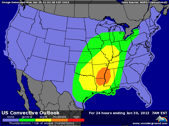
Update for today:

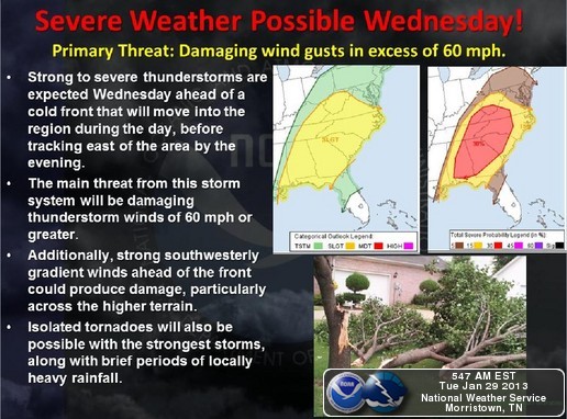
Update for Wednesday:

The is also a climate graphic linked on that page, looks like we may break a hi temp record today.
On a "animals behaving odd" sidenote: There is an exotic animal sanctuary within hearing distance of my home. This morning those animals are grumpy and loud. I have never heard such a mess of noise coming from that place. It really is freaky sounding!!

www.wunderground.com
It may still be January but severe weather is on tap for the South, lower Midwest, and eventually the mid-Atlantic U.S. from late Monday night through Tuesday and Wednesday. While there is a risk of tornadoes in this storm system, the largest and most widespread threat will be from straight-line wind damage. Given the speed of the jet stream, which will be whipping far above the Earth at around 150 mph, the storms are going to be moving QUICK—some as fast as 70mph
Update for Wednesday:

www.srh.noaa.gov
A cold front will sweep into the region on Wednesday, bringing strong to severe thunderstorms before it exits the area by the evening. Powerful winds will be the primary impact from this storm system as strong wind gusts from thunderstorms and gusty winds ahead of the front could produce damage in some areas. Additionally, brief periods of locally heavy rainfall will be possible, along with the possibility of a few isolated tornadoes.
The is also a climate graphic linked on that page, looks like we may break a hi temp record today.
On a "animals behaving odd" sidenote: There is an exotic animal sanctuary within hearing distance of my home. This morning those animals are grumpy and loud. I have never heard such a mess of noise coming from that place. It really is freaky sounding!!
Not sure where anyone else lives but I'm on the southern east coast(states).
it's been a very warm winter(basically t-shirt weather) in fact it's a beautiful sunny day so far,it started with fog
and usually colder weather follows.
So if we get any bad weather worth talking about I'll update my post.
it's been a very warm winter(basically t-shirt weather) in fact it's a beautiful sunny day so far,it started with fog
and usually colder weather follows.
So if we get any bad weather worth talking about I'll update my post.
edit on 29-1-2013 by TWILITE22 because: (no reason given)
I use to live in Michigan and it never I mean never came close to 60 at least not until May.
Originally posted by lasertaglover
reply to post by kdog1982
Great looking out for a lot of people. I hope they stay safe, and thanks to threads like this, properly posted in the Fragile Earth section like it should be, maybe some people might be safer because of it.
And I know the 'everything is normal' people will disagree, but this weather is not normal.
Two weeks ago here in SE Michigan, I was out biking with my kids. Last night we picked up about two inches of snow in my area, highs were in the 20's, followed by freezing rain. Right now, its raining.
Tomorrow we are forecast for 58, with a good chance of breaking the record and hitting 60. By Thursday its going to be back in the 20's here.
Yeah, normal...whatever.
Star and flag!
Peace
I bet you guys are loving it! I remember the long cold snowy winters Michigan can have,lol It would warm into the 40's and felt like springtime jackets would fly off and everyone would come out of hibernation,some that haven't been seen for months! yep people in Michigan definetly knows how to enjoy a warm winter day.
new topics
-
A Flash of Beauty: Bigfoot Revealed ( documentary )
Cryptozoology: 4 hours ago -
Fire insurance in LA withdrawn months ago
General Conspiracies: 7 hours ago
top topics
-
Fire insurance in LA withdrawn months ago
General Conspiracies: 7 hours ago, 7 flags -
A Flash of Beauty: Bigfoot Revealed ( documentary )
Cryptozoology: 4 hours ago, 5 flags -
Bizarre Labour Party Tic Toc Video Becomes Even More Embarrassing
Regional Politics: 15 hours ago, 4 flags
active topics
-
Trump says ownership of Greenland 'is an absolute necessity'
Other Current Events • 87 • : bastion -
Planned Civil War In Britain May Be Triggered Soon
Social Issues and Civil Unrest • 30 • : andy06shake -
Regent Street in #London has been evacuated due to a “bomb threat.”
Other Current Events • 8 • : TimBurr -
A Flash of Beauty: Bigfoot Revealed ( documentary )
Cryptozoology • 3 • : BeyondKnowledge3 -
Fire insurance in LA withdrawn months ago
General Conspiracies • 23 • : Flyingclaydisk -
Judge rules president-elect Donald Trump must be sentenced in 'hush money' trial
US Political Madness • 86 • : Flyingclaydisk -
The Truth about Migrant Crime in Britain.
Social Issues and Civil Unrest • 44 • : angelchemuel -
My personal experiences and understanding of orbs
Aliens and UFOs • 41 • : WeMustCare -
-@TH3WH17ERABB17- -Q- ---TIME TO SHOW THE WORLD--- -Part- --44--
Dissecting Disinformation • 3982 • : WeMustCare -
Los Angeles brush fires latest: 2 blazes threaten structures, prompt evacuations
Mainstream News • 298 • : Flyingclaydisk

