It looks like you're using an Ad Blocker.
Please white-list or disable AboveTopSecret.com in your ad-blocking tool.
Thank you.
Some features of ATS will be disabled while you continue to use an ad-blocker.
share:
reply to post by westcoast
Is there any fracking going on where you are? I was reading somewhere that they use infrasonics to locate drilling sites. Ultra low frequency sound waves can be bad for us.
Personally I am hoping that it is not just some greedy industry looking for natural gas, as the Pacific Northwest is one of my favorite places on the planet.
reply to post by Witness2008
Just answered my own question. Yahoo....no fracking in Washington or Oregon. Nearest fracking sites to you are in Alberta.
earthjustice.org...
Just answered my own question. Yahoo....no fracking in Washington or Oregon. Nearest fracking sites to you are in Alberta.
earthjustice.org...
reply to post by Witness2008
Yup...no fracking here yet. (thank goodness)
I've always wondered about undersea volcanos. Some newer ones have been found off our coast in the past few years.
Yup...no fracking here yet. (thank goodness)
I've always wondered about undersea volcanos. Some newer ones have been found off our coast in the past few years.
Small, but rapid-fire movement at the Mendocino Triple Junction.
USGS
The tremor has been active under the southern half of the CSZ over the past 24 hours, too.
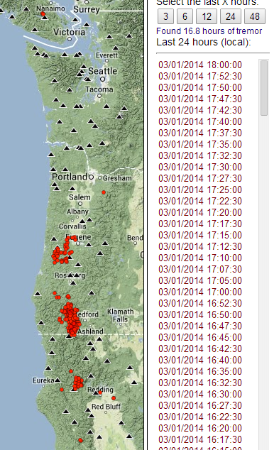
source(hit the "24" button)
3.1
33km SSW of Ferndale, California
2014-03-02 03:01:25 UTC7.1 km
2.4
32km SSW of Ferndale, California
2014-03-02 03:00:09 UTC7.0 km
2.7
33km SSW of Ferndale, California
2014-03-02 02:56:37 UTC6.5 km
1.9
32km SSW of Ferndale, California
2014-03-02 02:39:48 UTC7.1 km
USGS
The tremor has been active under the southern half of the CSZ over the past 24 hours, too.

source(hit the "24" button)
edit on 3/1/2014 by Olivine because: add link and pic
edit on 3/1/2014 by Olivine because: one soCal quake in the list that
should not have been--oops
reply to post by Olivine
Hmmmm.....
This is REALLY interesting, in light of the 6.9 West of this location tonight. We'll have to be sure and pay attention to the tremors these next few days.
Hmmmm.....
This is REALLY interesting, in light of the 6.9 West of this location tonight. We'll have to be sure and pay attention to the tremors these next few days.
reply to post by westcoast
What I find interesting is that after more than 2 months of nearly non-stop ETS, the tremor stopped under northern California on March 6th. Quiet for 4 days....then Snap...the Mag 6.9 hits.
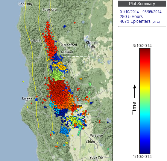
Wech-O-Meter
What I find interesting is that after more than 2 months of nearly non-stop ETS, the tremor stopped under northern California on March 6th. Quiet for 4 days....then Snap...the Mag 6.9 hits.

Wech-O-Meter
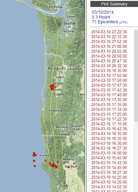
source -- PNSN tremor page
It's hard to tell exactly, but the smattering of offshore tremor on this map must surely be generated by the aftershocks of the mag 6.8, right? Strangely, I can only match one of the tremor bursts (time-wise) to a USGS listed quake.
The red dot below "Eureka" occurred 30 minutes before the lone foreshock (Mag 3.3 @ 05:04:09UTC) to the main show (Mag 6.8 @ 05:18:13UTC). All of the remaining tremor on the map came after.
It is good to know that the tremor network can detect "tremor/movement" off the coast. I've never seen it that far offshore before.
edit on
3/11/2014 by Olivine because: forgot a sentence
edit on 3/11/2014 by Olivine because: (no reason given)
reply to post by Olivine
Thank you for keeping this thread updated, Olivine.
I wanted to give this thread a nudge...since Kamchatka, Alaska and now Chile have released some stress, am hoping the 6.8 was enough of a stress release for Cascadia to return to gurgling in smaller magnitudes.
Thank you for keeping this thread updated, Olivine.
I wanted to give this thread a nudge...since Kamchatka, Alaska and now Chile have released some stress, am hoping the 6.8 was enough of a stress release for Cascadia to return to gurgling in smaller magnitudes.
JohnVidale
reply to post by westcoast
We tend not to interpret any one instance of apparent correlations of widely spread earthquakes. When examining decades of data, we find that triggering of distant earthquakes is very uncommon, although it has been seen for small triggered events in several cases.
The new aspect of these two quakes last night is their size and complexity. The M8.6 and the M8.2 are now the two biggest recorded strike-slip earthquakes, and they struck is a place that was not an obvious thoroughgoing fault. I don't know what this means, exactly, except that every year we get less and less confident that we know what is likely to happen next.
This is complete nonsense. Don't believe their propaganda. There is no reason for there to be such an implied near magnitude limitation for strike slip quakes, nor that quakes like that would be even remotely near to being the biggest such types of those quakes. This is more fantasy and lies from officials that want to keep control of all information and keep everything wrong.
There is absolutely no limitation to the magnitude of a strike slip earthquake in any more way than there is to one of a subduction zone. This is pure lies that they continue to spew out. In reality, the two most dangerous and most powerful fault zones on the planet are both strike slip faults, which just proves how much BS this is. But that's why they make these lies up, so people will remain that totally clueless, and not be as worried about the most threatening fault zones as they should be.
You see comments in this site all the time that confirm the propaganda works.
edit on 5-4-2014 by Red Cloak because: (no reason given)
Olivine
source -- PNSN tremor page
It's hard to tell exactly, but the smattering of offshore tremor on this map must surely be generated by the aftershocks of the mag 6.8, right? Strangely, I can only match one of the tremor bursts (time-wise) to a USGS listed quake.
The red dot below "Eureka" occurred 30 minutes before the lone foreshock (Mag 3.3 @ 05:04:09UTC) to the main show (Mag 6.8 @ 05:18:13UTC). All of the remaining tremor on the map came after.
It is good to know that the tremor network can detect "tremor/movement" off the coast. I've never seen it that far offshore before.edit on 3/11/2014 by Olivine because: forgot a sentenceedit on 3/11/2014 by Olivine because: (no reason given)
I just saw this post! You're right, that IS odd. I've never seen off-shore tremor either.
Here is the latest map for the past few weeks. Note there was a bit of tremor picked up off-shore further north more recently. Odd.
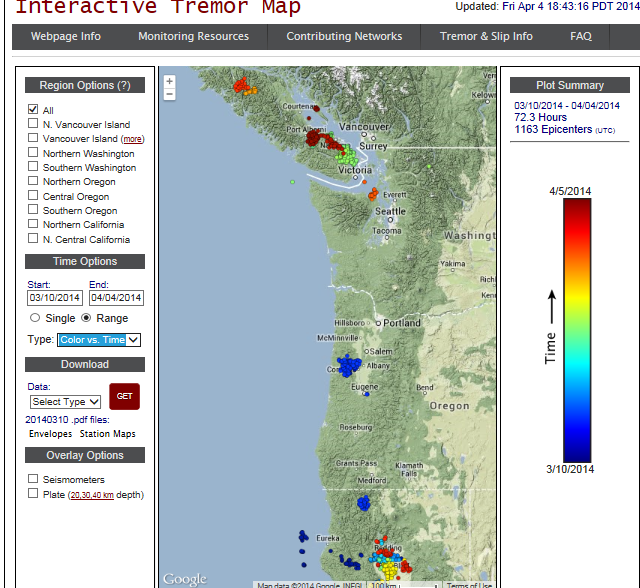
I'm going to ask Mr. Welsh about it.
And redcloak, not sure what to make of that. I have always found the scientists that I've interacted with to be open and I don't see why they would hide anything. I think they are very reluctant to speak in absolutes because of the nature of it. Its unpredictable. Which faults are you talking about?
Take what I say with a huge pinch of salt as I am not an expert in any way, just an interested follower.
From my interpretation of the eqs over the recent past, the eqs around this area of oregon over the last month seem to be concentrated in a circle about 10 miles around Battle Ground between Forest Grove District State Forest and the Silver Star Scenic area. I have done a couple of graphs which show the depths and positions of these. I can give more info on how these graphs were done, which areas were included, etc if necessary.
orgon & surrounding areas depth against latitude
orgon & surrounding areas depth against longitude
Google map of area 45.8N,122.5W
I cannot upload images, thats why they are on an external site.
Hi gang!
I like your graphs qmantoo--sorted by lat and lon gives a different perspective on the activity.
Hi westcoast. Any feedback from Mr. Wech? I found those offshore tremors really odd.
Okay, I just stumbled upon some data that is a new source to me. Always a fun treat. I honestly don't know if it has any relevance to our interest in Cascadia, or not. I'll let you all decide.
Have you heard of the phenomenon of well water fluctuations possibly proceeding earthquakes?
There is a newer publication that addresses ground water responses to near and distant earthquakes, as well as precursor hydrologic events. Read it here
Alright, back to the data.
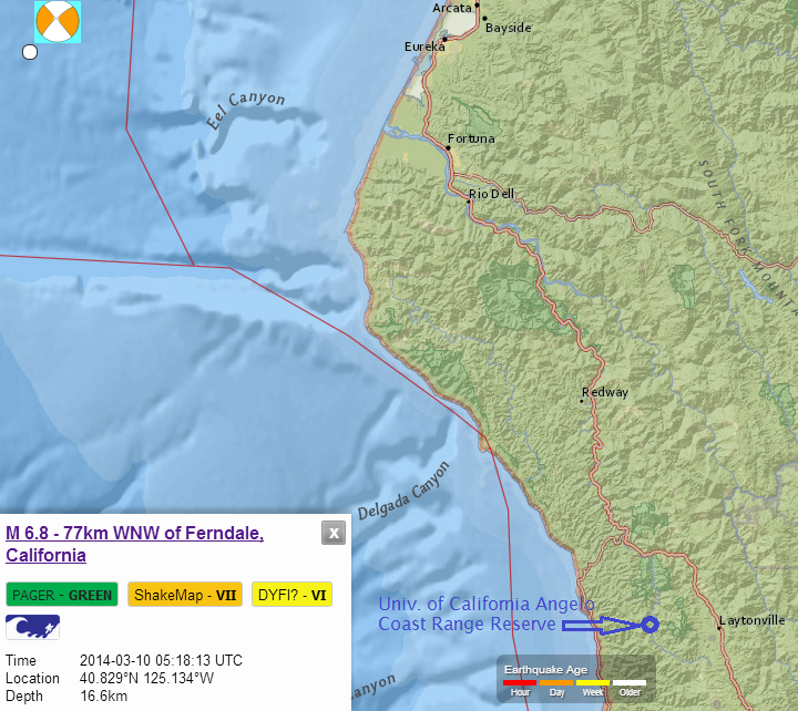
The Angelo Coast Range Reserve is a small research station run by the University of California located about 120 kms SE of the Mendocino Triple Junction.
(I've plopped its location into the map showing the Magnitude 6.8 Gorda plate earthquake of 10 March 2014.no laughing at my childish paint skillz)
This is what caught my attention; the big drop in well levels at 2 shallow wells and 3 deep wells, two days ago.
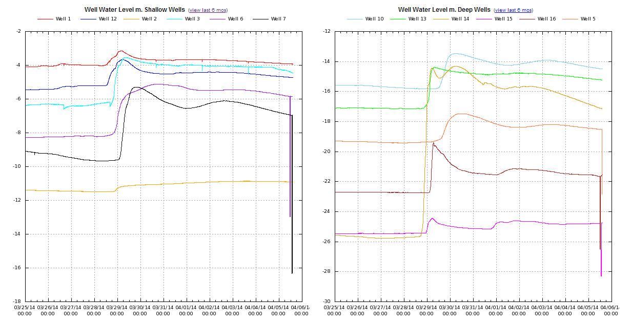
Link to source
Here is an image of the well water levels over the past 6 months.
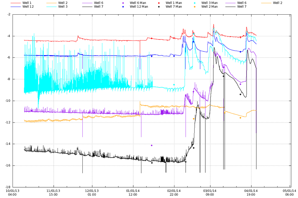
image source
I haven't yet tried to see the water levels day-by-day (I was in a hurry to share this info), but it looks to me like the previous big water level drop happened on 10 March. The day of the big quake.
I'm hoping I can access the 30-minute data to see if this drop proceeded the mag 6.8 or not.
So, it(the water level drop) may have just been a coincidence. (I don't think so.)
And now we have an equally large water level drop, but no earthquake.....yet.
FWIW, when I looked over the historic data for quakes near the southern end of the CSZ, they have a tendency to come in loose bunches--meaning days, weeks, even many months apart--followed by years of relative quiet. I have a gut feeling a similar sized earthquake is probable, in the short term.
I'm off to scour for more tidbits...
I like your graphs qmantoo--sorted by lat and lon gives a different perspective on the activity.
Hi westcoast. Any feedback from Mr. Wech? I found those offshore tremors really odd.
Okay, I just stumbled upon some data that is a new source to me. Always a fun treat. I honestly don't know if it has any relevance to our interest in Cascadia, or not. I'll let you all decide.
Have you heard of the phenomenon of well water fluctuations possibly proceeding earthquakes?
There is a newer publication that addresses ground water responses to near and distant earthquakes, as well as precursor hydrologic events. Read it here
Alright, back to the data.
The Angelo Coast Range Reserve is a small research station run by the University of California located about 120 kms SE of the Mendocino Triple Junction.
(I've plopped its location into the map showing the Magnitude 6.8 Gorda plate earthquake of 10 March 2014.no laughing at my childish paint skillz)

This is what caught my attention; the big drop in well levels at 2 shallow wells and 3 deep wells, two days ago.

Link to source
Here is an image of the well water levels over the past 6 months.

image source
I haven't yet tried to see the water levels day-by-day (I was in a hurry to share this info), but it looks to me like the previous big water level drop happened on 10 March. The day of the big quake.
I'm hoping I can access the 30-minute data to see if this drop proceeded the mag 6.8 or not.
So, it(the water level drop) may have just been a coincidence. (I don't think so.)
And now we have an equally large water level drop, but no earthquake.....yet.
FWIW, when I looked over the historic data for quakes near the southern end of the CSZ, they have a tendency to come in loose bunches--meaning days, weeks, even many months apart--followed by years of relative quiet. I have a gut feeling a similar sized earthquake is probable, in the short term.
I'm off to scour for more tidbits...
edit on 4/8/2014 by Olivine because: (no reason given)
edit on 4/8/2014 by Olivine
because: refining
reply to post by Olivine
this guy,,

wrote some very,,very, interesting observations,, on said subject,,
this guy,,

wrote some very,,very, interesting observations,, on said subject,,
reply to post by BobAthome
Interesting Bob, I didn't know that. Do you have a link so I might have a read?
Interesting Bob, I didn't know that. Do you have a link so I might have a read?
Anybody else been watching the tremor under the Puget Sound area over the last 6 days?
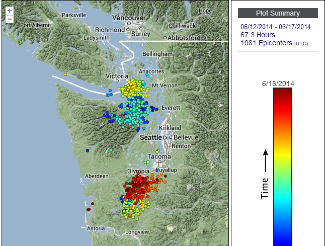
tremor map
If this is the start of the next tremor episode under Washington state, it is waaay early. That would make it only 9.25 months since the start of the previous episode in 2013.
It's a big 'if'.
It is a strange beginning--2 discrete pockets of tremor on either side of the arch. I'll just have to watch to see if it continues.
In the early years after discovery of the tremor under Washington, the episodes were spaced about 14 months apart. But the past 7 cycles have had the following intervals:
2008, 30 April thru 2 June
2009, 27 April thru last week of May (Early--about 12 months)
2010, 8 August thru 8 Sept (Late--about 15.25 months)
2011, 23 July thru 3 Sept (Early--about 11.5 months)
2012, 30 August thru 11 Oct (Early--about 12.25 months)
2013, 7 Sept thru 8 Oct (Early--about 12.25 months)
2014, Starting now???, 12 June (Really Early--that would make it about 9.25 months since the beg. 2013)
I'm thinking the 1st few years of observation were not enough to declare a regular 14-month cycle. Every 12-months or so, seems closer. Either that, or Cascadia's rhythms are speeding up...
a reply to: AlexanderM
Hi AlexanderM, i'm only 2+ months late to reply.
Tremor quieted down after the first week in July, and then began slowly ramping back up in mid-August. Now it is showing action up and down the CSZ, except for the northern Oregon portion.
Take a look at the deep tremor just for yesterday: 52.1 hours and 867 epicenters is a lot of tiny, deep popping.
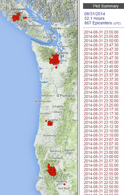
PNSN tremor page
Here is the tremor density for the past 3 weeks: (click images to enlarge)

And this image shows only the past week; blue is older, red is most recent.

I haven't seen any corresponding movement on GPS yet, but it should begin showing up if this activity continues.
Hi AlexanderM, i'm only 2+ months late to reply.
Tremor quieted down after the first week in July, and then began slowly ramping back up in mid-August. Now it is showing action up and down the CSZ, except for the northern Oregon portion.
Take a look at the deep tremor just for yesterday: 52.1 hours and 867 epicenters is a lot of tiny, deep popping.

PNSN tremor page
Here is the tremor density for the past 3 weeks: (click images to enlarge)

And this image shows only the past week; blue is older, red is most recent.

I haven't seen any corresponding movement on GPS yet, but it should begin showing up if this activity continues.
edit on 9/1/2014 by Olivine because: wording
Actually it's when it goes virtually silent that you need to stay on it !!
This thread needs some new life !!!
If you follow eq's be sure to check usgs and Canada's eq map...I never realized how active the East and West coastal areas are there in Canada !!!a reply to: Olivine
This thread needs some new life !!!
If you follow eq's be sure to check usgs and Canada's eq map...I never realized how active the East and West coastal areas are there in Canada !!!a reply to: Olivine
a reply to: ujustneverknow
I agree it’s that time again where we need to watch and discuss events now and the ones to come. Is this the calm before the storm?
I agree it’s that time again where we need to watch and discuss events now and the ones to come. Is this the calm before the storm?
new topics
-
Federal law trumps state and local law every time
Social Issues and Civil Unrest: 4 hours ago
top topics
-
DOJ Special Counsel Robert HUR Says JOE BIDEN Can Be ARRESTED After Jan 20th 2025.
Above Politics: 17 hours ago, 12 flags -
Federal law trumps state and local law every time
Social Issues and Civil Unrest: 4 hours ago, 10 flags
active topics
-
Interesting Video-UFO?
Aliens and UFOs • 14 • : BeyondKnowledge3 -
Federal law trumps state and local law every time
Social Issues and Civil Unrest • 12 • : Lazy88 -
Ed Dowd some good news
Medical Issues & Conspiracies • 39 • : chr0naut -
Post A Funny (T&C Friendly) Pic Part IV: The LOL awakens!
General Chit Chat • 7829 • : KrustyKrab -
I thought Trump was the existential threat?
World War Three • 74 • : PorkChop96 -
DOJ Special Counsel Robert HUR Says JOE BIDEN Can Be ARRESTED After Jan 20th 2025.
Above Politics • 20 • : Flyingclaydisk -
Well, here we go red lines crossed Biden gives the go ahead to use long range missiles
World War Three • 373 • : bastion -
Petition Calling for General Election at 564,016 and rising Fast
Political Issues • 90 • : gortex -
Russia Ukraine Update Thread - part 3
World War Three • 6889 • : Oldcarpy2 -
The Acronym Game .. Pt.4
General Chit Chat • 990 • : KnowItAllKnowNothin
