It looks like you're using an Ad Blocker.
Please white-list or disable AboveTopSecret.com in your ad-blocking tool.
Thank you.
Some features of ATS will be disabled while you continue to use an ad-blocker.
share:
Still picking up activity in the beautiful NW.
There was another small Mag 4.0 out near the transform fault, and now the Newberry volcano is shaking a bit. The 4 EQ's yesterday were shallow, the 2 in the past hour were deeper in the crust--probably not related to the volcano, but who knows?
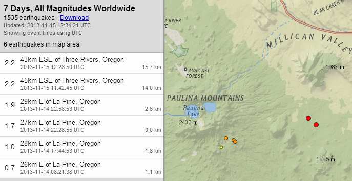
image source
......................
While searching for any research published using the 1st few years of ocean-bottom seismometer data (which I didn't find yet ), I found this week-old interview of one of the Cascadia Initiative lead researchers. 1859 Oregon Magazine
He had this to say regarding slow earthquakes:
He is also doing MT (magnetotelluric) experiments along the PNW coast, and explains how this data may help better understand the mechanisms at work along the Wadati-Benioff zone (subduction zone):
There was another small Mag 4.0 out near the transform fault, and now the Newberry volcano is shaking a bit. The 4 EQ's yesterday were shallow, the 2 in the past hour were deeper in the crust--probably not related to the volcano, but who knows?

image source
......................
While searching for any research published using the 1st few years of ocean-bottom seismometer data (which I didn't find yet ), I found this week-old interview of one of the Cascadia Initiative lead researchers. 1859 Oregon Magazine
He had this to say regarding slow earthquakes:
Our seismometers on the ocean floor will help us determine if slow earthquakes are happening there, too. These quakes enable slipping, east of where the two plates are stuck together. Some scientists think that these slow earthquakes serve to put more load, called stress, on the locked zone, which makes it more likely to pop. In the extreme, imagine one last slow earthquake pushing the locked zone over its limit—stressing it out—and triggering a massive earthquake.
He is also doing MT (magnetotelluric) experiments along the PNW coast, and explains how this data may help better understand the mechanisms at work along the Wadati-Benioff zone (subduction zone):
We’re setting a 200-mile-long grid of magnetometers and electric dipole measurement equipment in the coastal range, from Coos Bay, Oregon to Aberdeen, Washington. These magnetotelluric measurements tell us how the earth conducts electricity, and we can use the data to make conductivity models in three dimensions. Conductivity reveals the presence of fluids where the two plates meet. These fluids help bits of the ocean crust melt when dragged to great depths and pressures below the Cascades’ volcanoes. We’re interested in what role fluids play in the rock-cracking associated with those slow earthquakes.
My theory is that pockets of fluids along faults rupture just before an earthquake. So with magnetotellurics, we’re looking for changes in the current flow, potentially signaling an earthquake. Our models have detected these changes.
edit on 11/15/2013 by Olivine because: my
coffee needed warming
reply to post by Olivine
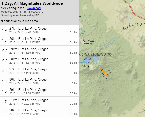
The # of events, locations, and depths have been revised. Most of them are closer to the volcano now.
USGS source map
The # of events, locations, and depths have been revised. Most of them are closer to the volcano now.

USGS source map
edit on 11/15/2013 by Olivine because: they
changed locations again--hopefully this is final
Activity has been ticking incrementally upward over the past few weeks in the PNW; notching up the energy output with the
Mag 5.5 last evening.
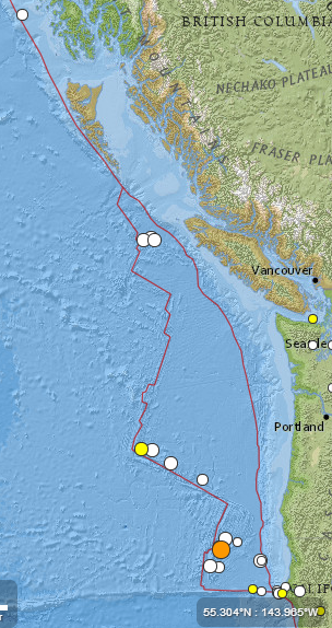
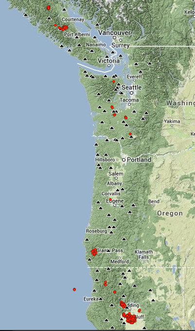
This image shows the deep tremor over the past 48 hours. There has been a persistant patch under northern California, and sporadic "burbles" up-and-down the length of the subduction zone.
source(click the "48" button)
Check out this next image of GPS station P158 (Fortuna, CA) , which can be found on the UNVACO page here.
Now click the "station position" image to view a larger version and you can use the arrows to see the cleaned data.
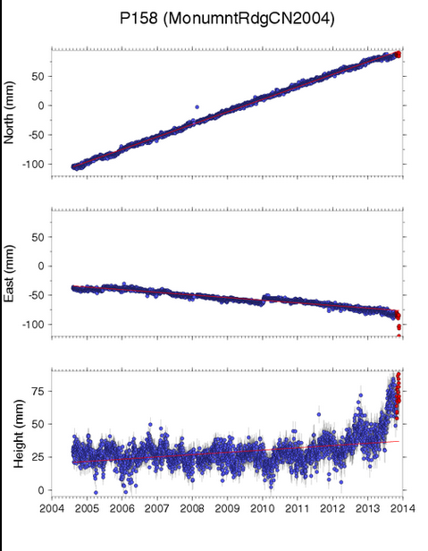
It shows that the GPS station has moved west 50mm over the past 10 days or so. The ground at this location has also been shoved steadily skyward over the past 10-11 months.
Now, on that same page (sorry, it won't link directly), click the red "Nearby GPS Plots" link. It will show a snapshot of the surrounding monuments' movements. Their locations in California are shown in the map to the right.
If you have the time to mess around with the UNVACO real-time GPS data, or the USGS GPS monitoring page, you will see similar departures from "normal" trends in the data along the PNW.
I don't know what it means, but I "feel" like it is showing something building, and I don't think the Mag 5.5 last night was the end of it.

This image shows the deep tremor over the past 48 hours. There has been a persistant patch under northern California, and sporadic "burbles" up-and-down the length of the subduction zone.
source(click the "48" button)

Check out this next image of GPS station P158 (Fortuna, CA) , which can be found on the UNVACO page here.
Now click the "station position" image to view a larger version and you can use the arrows to see the cleaned data.

It shows that the GPS station has moved west 50mm over the past 10 days or so. The ground at this location has also been shoved steadily skyward over the past 10-11 months.
Now, on that same page (sorry, it won't link directly), click the red "Nearby GPS Plots" link. It will show a snapshot of the surrounding monuments' movements. Their locations in California are shown in the map to the right.
If you have the time to mess around with the UNVACO real-time GPS data, or the USGS GPS monitoring page, you will see similar departures from "normal" trends in the data along the PNW.
I don't know what it means, but I "feel" like it is showing something building, and I don't think the Mag 5.5 last night was the end of it.
edit on 12/1/2013 by Olivine because: (no reason given)
Hi all. I just wanted to take note of this moderate earthquake near the north end of the subduction zone.
Mag 4.7 124 km WNW of Tofino, B.C. Canada
If the depth is accurate (and isn't revised), this quake was very likely on the interface between the Pacific and North American plates.
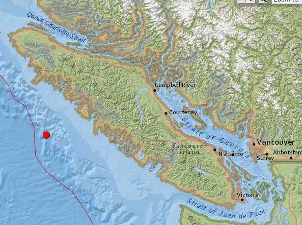
map USGS
There was just a smattering of tremor proceeding this quake.
Finally, here is a look at a nearby seismogram PB.B928.BHZ
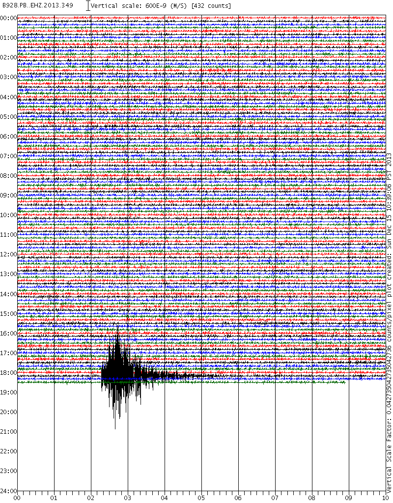
If the depth is accurate (and isn't revised), this quake was very likely on the interface between the Pacific and North American plates.

map USGS
There was just a smattering of tremor proceeding this quake.
Finally, here is a look at a nearby seismogram PB.B928.BHZ

reply to post by Olivine
Hmmm....looks like a slow rumble.
This area has produced several moderate sized quakes in the past couple years. I think that it is normally written off as coming from a different fracture (not the CSZ).
I'll see what the PNSN says...
Hmmm....looks like a slow rumble.
This area has produced several moderate sized quakes in the past couple years. I think that it is normally written off as coming from a different fracture (not the CSZ).
I'll see what the PNSN says...
reply to post by westcoast
Ah, I forgot about the Nootka fault.
It's definitely hard to discern where it originated with only a depth (5 km). I don't think they give focal mechanisms for quakes this small, but one would be helpful...
Did John and company have any insight?
Ah, I forgot about the Nootka fault.
It's definitely hard to discern where it originated with only a depth (5 km). I don't think they give focal mechanisms for quakes this small, but one would be helpful...
Did John and company have any insight?
reply to post by Olivine
Good call! He basically said the same thing....that without the focal mechanism, it is hard to say for sure. He felt though that with the given location and depth, he doesn't think it was from the trench.
Good call! He basically said the same thing....that without the focal mechanism, it is hard to say for sure. He felt though that with the given location and depth, he doesn't think it was from the trench.
reply to post by westcoast
I finally logged on to the dreaded fb to read his commentary. He did say it could have been on the plate interface. Wherever it originated it was relatively small, which is good.
Elsewhere along the CSZ....a rapid-fire "pop pop pop" near the Mendocino Triple Junction, 20 minutes ago.
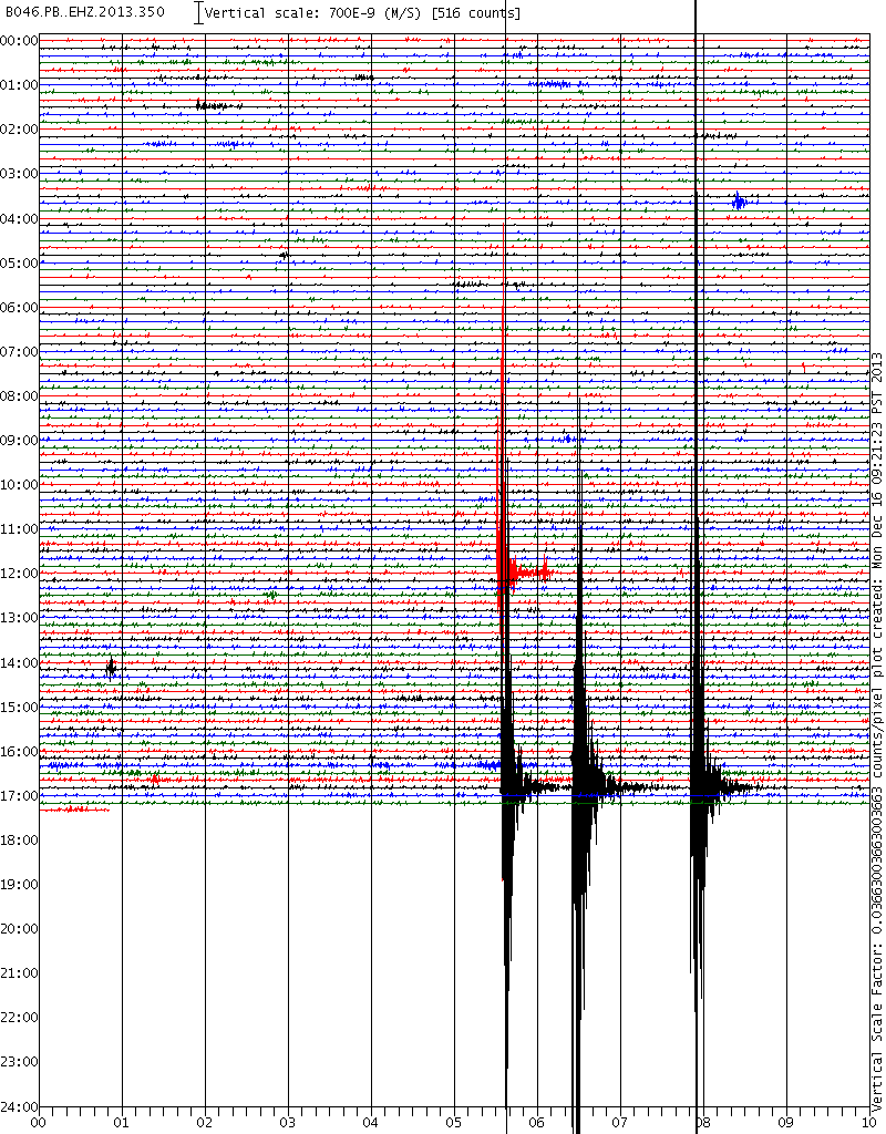
IRIS PB.B046.BHZ
I finally logged on to the dreaded fb to read his commentary. He did say it could have been on the plate interface. Wherever it originated it was relatively small, which is good.
Elsewhere along the CSZ....a rapid-fire "pop pop pop" near the Mendocino Triple Junction, 20 minutes ago.

IRIS PB.B046.BHZ
I haven't checked on the tremor in a few days. I found there was a goodly amount for the 24th.
HoHoHo!
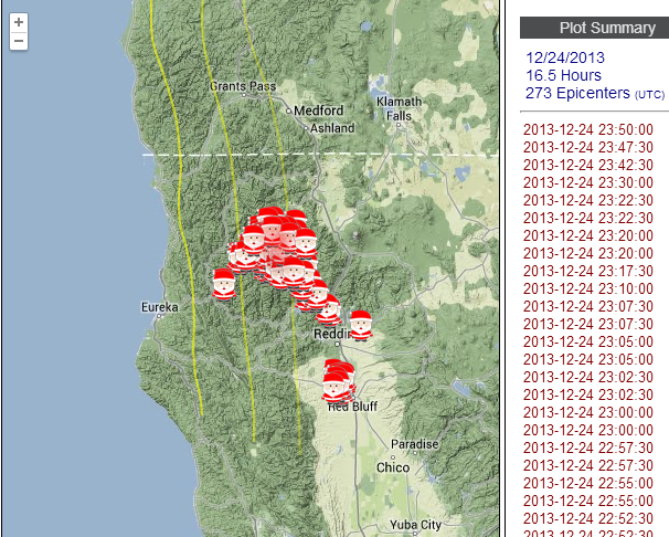
source of the much too cute Santa map
Have a joyous holiday everyone!
HoHoHo!

source of the much too cute Santa map
Have a joyous holiday everyone!
Olivine
I haven't checked on the tremor in a few days. I found there was a goodly amount for the 24th.
HoHoHo!
source of the much too cute Santa map
Have a joyous holiday everyone!
DUDETT.........! Those Santa's are so funny
I always appreciate what you have to say around here! And being the BOOB that I am, I have always assumed you were of the male gender(hehehehe)...man, what do I know!
Merry Christmas!!!
That tremor is right next store to the 4.7 at the junction
edit on 24-12-2013 by radpetey because: (no reason given)
reply to post by radpetey
Yes, I'm a dudette, lol!
After I posted the santa tremor map, I went back to the PNSN tremor map page and zoomed in. Smack in the middle of the santas was a Homer Simpson santa face. Then I fiddled with the map settings and I could never get the Homer face to come back. I think it may have been a one-time Easter egg (or stocking stuffer ).
The tremor has been "on" pretty much for the past 15 days; jumping around from the South to North and back South again.
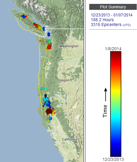
The most recent 5 days have shown concentrated activity in the north central California area.
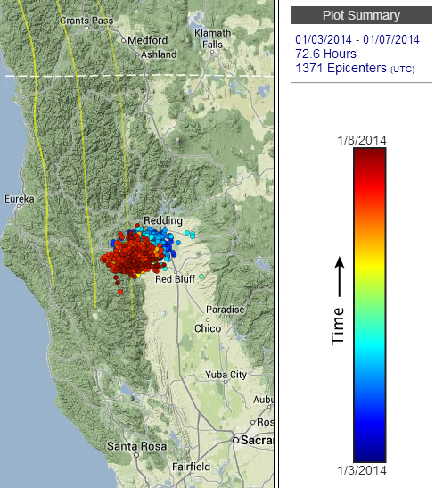
I'm anticipating another Mag 4 "ish" size earthquake near the triple junction in the next 24 hours or so.
[Disclaimer: since I have "said this out loud" it is certain to not happen--that's how my predictions roll...]
Yes, I'm a dudette, lol!
After I posted the santa tremor map, I went back to the PNSN tremor map page and zoomed in. Smack in the middle of the santas was a Homer Simpson santa face. Then I fiddled with the map settings and I could never get the Homer face to come back. I think it may have been a one-time Easter egg (or stocking stuffer ).
The tremor has been "on" pretty much for the past 15 days; jumping around from the South to North and back South again.

The most recent 5 days have shown concentrated activity in the north central California area.

I'm anticipating another Mag 4 "ish" size earthquake near the triple junction in the next 24 hours or so.
[Disclaimer: since I have "said this out loud" it is certain to not happen--that's how my predictions roll...]
New study that just came out: 'Earthquakes amplified in silty Vancouver basin: study
www.cbc.ca...
So what do you guys think it means? Are we in even bigger trouble than we thought?
www.cbc.ca...
'
New research is shaking up the entire notion of what could happen to the Vancouver area during an earthquake, indicating bridges and tall buildings would rattle and sway a whole lot more than previously thought.
Two studies published Monday in the Bulletin of the Seismological Society of America show that seismic waves are amplified as they pass through the Georgia Basin, the deposit of softer sedimentary rock that lies partly beneath Metro Vancouver.
5 biggest quakes to hit B.C.
Top 10 essentials for your earthquake kit
If a quake occurred within 100 kilometres of the city, such amplification could make the ground quake three to four times more than it would if the basin were not there.
The authors say people driving in vehicles would notice the shaking and suggest it could damage even well-constructed buildings.
"The shaking in (Metro) Vancouver would be greater because of the presence of the Georgia Basin, especially when the earthquake occurred to the south or southwest," says lead author Sheri Molnar, who's in the University of British Columbia Civil Engineering department.
She says the waves would spread outward from the earthquake and would have to cross the deep southeast portion of the basin before hitting Vancouver. That would tend to cause the greatest increase in motion.
Bowl of Jell-O
Molnar says seismologists have known that sedimentary basins can increase shaking, but the influence of a basin in Canada has not been studied until now.
The Georgia Basin is shaped like an elongated bowl and lies beneath the Georgia Strait, between the Lower Mainland and Vancouver Island. It is one in a series of basins along the Pacific coast of North America, and is filled with layers of silt, sand and glacial deposits.
'We're bringing the earthquake up through the cheese, and then it's suddenly hitting the Jell-O mould and starting to slosh around and bounce around within that Jell-O.'
- Sheri Molnar, UBC Civil Engineering, describes seismic waves in the Georgia Basin
She compares the Georgia Basin to gelatin surrounded by a hard block of cheese.
"We're bringing the earthquake up through the cheese, and then it's suddenly hitting the Jell-O mould and starting to slosh around and bounce around within that Jell-O."
British Columbia sits on what's known as the Cascadia subduction zone, where earthquakes tend to occur either within the Juan de Fuca plate or the overriding North America plate. Big subduction earthquakes, like the one that struck Japan in 2011, also occur in the Juan de Fuca plate.
earthquake-magnitude
TOP 5: Biggest earthquakes to hit B.C. (CBC)
Molnar's studies examined the potential impact of deep earthquakes, with a magnitude of 6.8, that occur 40 to 50 kilometres beneath the surface, as well as shallow earthquakes of the same magnitude.
Molnar and her colleagues used computers to look at the impact on tall buildings or long structures. Using three-dimensional simulations of different scenarios, the team found that both deep and shallow earthquakes led to greater shaking if the seismic energy moved through the Georgia Basin.
Up until now, construction of buildings was based on the knowledge that softer ground would create stronger tremors during an earthquake.
But Natural Resources Canada researcher John Cassidy says soft materials beneath the surface — such as a basin — could also control the amount of rippling felt above.
'Instead of perhaps feeling strong shaking for 10 seconds, you might feel strong shaking for 20 or 30 seconds'
- John Cassidy, researcher with Natural Resources Canada
"Essentially what the basin is doing is producing stronger shaking and producing longer-duration shaking," said Cassidy, who supervised Molnar's study.
"Instead of perhaps feeling strong shaking for 10 seconds, you might feel strong shaking for 20 or 30 seconds."
Cassidy says the model showed that the area beneath the Georgia Strait shook the most.
Richmond, Delta, Ladner: 3 or 4 times stronger
When earthquake waves hit the southeast part of the Georgia Basin before reaching Metro Vancouver, southwestern areas such as Delta, Ladner and Richmond experienced tremors three or four times what they would be if the Georgia Basin were not there.
However, if the waves hit the northwestern or northeastern part of the basin, they took a different path and either did not affect the Vancouver area or did not cause a significant increase in motion.
Cassidy says the findings will help seismologists determine where to place more instruments to record future earthquakes. He also says the findings can be used to upgrade codes for buildings, bridges and other infrastructure to make them more structurally sound.
"If somebody is planning to put cables in the sea floor or any sort of infrastructure on the sea floor, this is really important information," he says.
"The best defence against earthquakes is through good, modern building codes."
So what do you guys think it means? Are we in even bigger trouble than we thought?
reply to post by phoenixlights321
It sounds like the evidence is pointing toward extreme shaking when a large earthquake happens.
It's not sexy or politically easy, but more emphasis on seismic retrofitting of important buildings such as schools and hospitals, seems like the prudent move. Maybe low-cost loans could be made available to homeowners/landlords to improve the safety of their structures, too. It's the right thing to do.
___________________________________
This image shows the detected tremor under the PNW over the past week. The 2 purple arrows (one near Eureka, CA, the other near Roseburg, OR) highlight an interesting pattern.
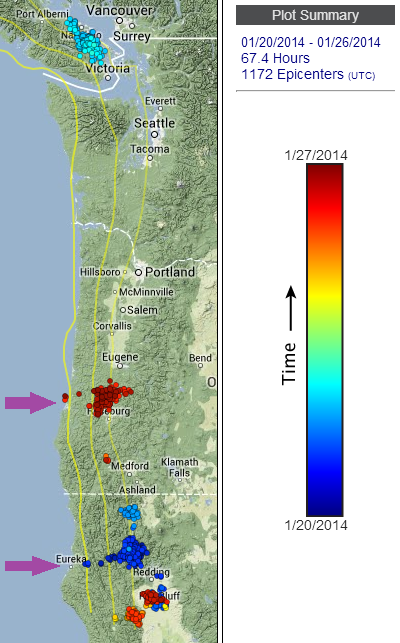
source(set to range 20-Jan to 26 Jan, color v time)
Near Eureka, on the 20th, the tremor started "running" west, toward the "locked" portion of the CSZ, back east, then west again.
Normally, the tremor stops its westward movement around the 25kms depth interface. As this map shows it moved more shallowly--up to 20 kms or so.
Next is the burst of activity near Roseburg. It's showing the same westward movement up to the 19-20 kms depth profie.
This deep tremor is still ongoing in this vicinity, as you can see on the real-time tremor map. (switch to 6 hours, and 12 hrs to see more. If you move your mouse over the times in the right-hand column, you can watch the tremor bounce around)
Just thought I would share.
It sounds like the evidence is pointing toward extreme shaking when a large earthquake happens.
It's not sexy or politically easy, but more emphasis on seismic retrofitting of important buildings such as schools and hospitals, seems like the prudent move. Maybe low-cost loans could be made available to homeowners/landlords to improve the safety of their structures, too. It's the right thing to do.
___________________________________
This image shows the detected tremor under the PNW over the past week. The 2 purple arrows (one near Eureka, CA, the other near Roseburg, OR) highlight an interesting pattern.

source(set to range 20-Jan to 26 Jan, color v time)
Near Eureka, on the 20th, the tremor started "running" west, toward the "locked" portion of the CSZ, back east, then west again.
Normally, the tremor stops its westward movement around the 25kms depth interface. As this map shows it moved more shallowly--up to 20 kms or so.
Next is the burst of activity near Roseburg. It's showing the same westward movement up to the 19-20 kms depth profie.
This deep tremor is still ongoing in this vicinity, as you can see on the real-time tremor map. (switch to 6 hours, and 12 hrs to see more. If you move your mouse over the times in the right-hand column, you can watch the tremor bounce around)
Just thought I would share.
Since I last posted in January, the tremor was very sporadic and jumpy. A bit of activity in the north, followed by a day on the southern end of the
zone, then maybe a day of no detected tremor, and so on.
Over the past 3 days the activity has been persistant and spread all along the CSZ. Here is a snapshot from the tremor page (set to range, 20th-22nd)

If you check out the real-time map and click the last 6 hours and 12 hours, you can see the tremor is still humming.
The cluster south of Eugene, OR hasn't seen that much tremor activity since Sept./Oct. 2012. There were a couple weeks of strong tremor in March 2013 NW of Eugene. This area is usually quiet, with much longer intervals between tremor episodes when compared to the Puget Sound area ETS, which experiences tremor episodes every 10-14 months.
If there were a candidate area for the "most locked" portion of the CSZ, central Oregon would get my vote; so I'll be watching closely.
Over the past 3 days the activity has been persistant and spread all along the CSZ. Here is a snapshot from the tremor page (set to range, 20th-22nd)

If you check out the real-time map and click the last 6 hours and 12 hours, you can see the tremor is still humming.
The cluster south of Eugene, OR hasn't seen that much tremor activity since Sept./Oct. 2012. There were a couple weeks of strong tremor in March 2013 NW of Eugene. This area is usually quiet, with much longer intervals between tremor episodes when compared to the Puget Sound area ETS, which experiences tremor episodes every 10-14 months.
If there were a candidate area for the "most locked" portion of the CSZ, central Oregon would get my vote; so I'll be watching closely.
reply to post by Olivine
Hey Olivine! Thanks again for these updates!
I totally agree with you. Not only about the Oregon area....but doesn't it seem like there really hasn't been the typical 'quiet faze' like the past couple of years? I really seems like there has been continuous tremor activity that has just decreased, but not stopped. I think the next 'active' period might be more interesting the next time around!
AND...it has been quiet for a bit now out in the locked zone by Canada. I wouldn't be surprised if we see something there again soon.
westcoast
reply to post by Olivine
....but doesn't it seem like there really hasn't been the typical 'quiet faze' like the past couple of years? I really seems like there has been continuous tremor activity that has just decreased, but not stopped. I think the next 'active' period might be more interesting the next time around!
AND...it has been quiet for a bit now out in the locked zone by Canada. I wouldn't be surprised if we see something there again soon.
I couldn't agree more.
It seems like there was a very brief period of quiet after the Puget Sound episode ended in October, but since the day after Christmas, there have been only 7 days without activity somewhere along the CSZ.
Refresh your BOB--just in case!
It was another active day yesterday:
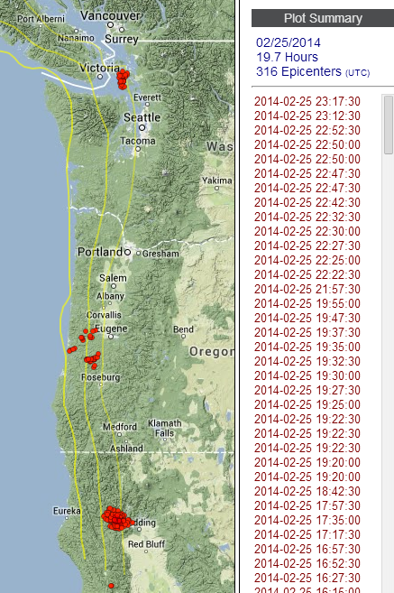
tremor map source
edit on 2/26/2014 by Olivine because: add a map
reply to post by Olivine
You know...this is really interesting.
I think you are familiar with the video I have recorded and shared over the years of an odd rumbling sound I hear occasionally? I have always suspected it was geological in nature, while others believe its coming from the Oak Harbor naval Base test firing jet engines. Its just that one time last year when it was REALLY loud, people that were over an hour and a half away from the base heard it! (I am about a 45 min drive) On days when its so loud, you feel it as much as hear it and I have a hard time believing its jet engines.
Best I can describe it, is the loud rumbling/roar you hear during a big quake that is building at the beginning(I've been in a 6.0, 6.7 and numerous smaller ones), right before it shakes. Except, right before it gets to the point where you start to duck - It suddenly cuts out. Gone. I bring it up now, because it was quite loud yesterday (could hear/feel it shaking in my house) and I notice there was tremor yesterday just West of me, where the rumbling comes from. (out in Northern Puget Sound)
I took some video of it on the 21st of this month. It makes the hairs rise on my neck whenever I hear it...pure instinct. You HAVE to where earphones when you listen to this. I can't stress that enough...you will NOT hear it without them, it is way too low. In this vid, I did something different. Rather than turning everything off and hushing everyone, I went ahead and recorded with all the background noise going and I think it actually added a lot of extra perception to it. I DON'T know what the weird breathing sounds are...seriously. That part is just plain weird, but you can clearly hear the 'rumbling' build and then abruptly cut out.
edit on 26-2-2014 by westcoast because: (no reason given)
reply to post by westcoast
I listened to your audio and found it very similar to the very low vibrations that I would sometimes hear during my few years living between Bangor and Seabeck on the hood canal. I could feel it in my body.
My thoughts are of infrasonics and the use of it for charting petroleum deposits and rock formations, along with monitoring earthquake activity.
Nice thread you have here.
reply to post by westcoast
Hey westcoast.
I find the sounds you've been hearing over the past years really puzzling. I've tried looking at the infrasound channel on A04D for times you've reported hearing them in the past, but never saw any conclusive signature. That station is probably too far away.
I was thinking...dangerous, yes? lol
What if the sounds are coming from Mt. Baker --possibly glacier movement-- and it is being amplified somehow by the nearby lakes at the base, before it is channeled down the Skagit River valley toward you?
Just a wild guess from looking at the surrounding terrain. Did you read David Hill's investigation of the sounds? His conclusion: it's difficult to pinpoint sources. Not much help.
edit on 2/28/2014 by Olivine because: (no reason given)
reply to post by Olivine
Hey Olivine! In December 2012, the scientist who runs the tremor program pulled the info from the infrasound seismo for me during the time period that I heard the rumbling. I think I also have a video uploaded that corresponds with this, as well as numerous other personal accounts from people I know around the valley. SO...plenty of correlation, just not a for sure cause. Here is a snapshot of the seismo:
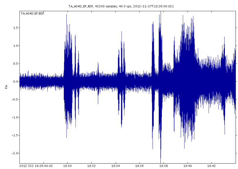
The first time I EVER heard this, it was also my first thought that it might be Baker and I actually checked the seismos to see if there was anything on it. There wasn't. Also, the sound is clearly coming from the West, out over the water, while Baker and Glacier are to my East. So I just don't know!
ETA: This is probably one of my best ones. I filmed this in December, so just a couple of months ago. At the .44 and 1.10 mark you hear it cut out so the loudness of it is obvious. You can even see that there is a vibration in the window screen. It's hard to explain how you can FEEL it as well as hear it. For people that tell me its just a jet flying over the base 40 miles away...well, the ONLY time a jet ever came close to creating this affect, is when it was buzzing me, like a few hundred feet above me. (when I was ON the base) So...NO. That is not it.
Again...you HAVE to wear earphones to hear it. Good ones.
Hey Olivine! In December 2012, the scientist who runs the tremor program pulled the info from the infrasound seismo for me during the time period that I heard the rumbling. I think I also have a video uploaded that corresponds with this, as well as numerous other personal accounts from people I know around the valley. SO...plenty of correlation, just not a for sure cause. Here is a snapshot of the seismo:

The first time I EVER heard this, it was also my first thought that it might be Baker and I actually checked the seismos to see if there was anything on it. There wasn't. Also, the sound is clearly coming from the West, out over the water, while Baker and Glacier are to my East. So I just don't know!
edit on 28-2-2014 by westcoast because: (no reason given)
ETA: This is probably one of my best ones. I filmed this in December, so just a couple of months ago. At the .44 and 1.10 mark you hear it cut out so the loudness of it is obvious. You can even see that there is a vibration in the window screen. It's hard to explain how you can FEEL it as well as hear it. For people that tell me its just a jet flying over the base 40 miles away...well, the ONLY time a jet ever came close to creating this affect, is when it was buzzing me, like a few hundred feet above me. (when I was ON the base) So...NO. That is not it.
Again...you HAVE to wear earphones to hear it. Good ones.
edit on 28-2-2014 by westcoast because: (no reason given)
new topics
-
Federal law trumps state and local law every time
Social Issues and Civil Unrest: 6 hours ago
top topics
-
Federal law trumps state and local law every time
Social Issues and Civil Unrest: 6 hours ago, 13 flags
active topics
-
DOJ Special Counsel Robert HUR Says JOE BIDEN Can Be ARRESTED After Jan 20th 2025.
Above Politics • 24 • : WeMustCare -
Comcast dumping MSNBC
Mainstream News • 33 • : WeMustCare -
International Criminal Court Issues Arrest Warrant For Netanyahu
Mainstream News • 53 • : WeMustCare -
President-Elect DONALD TRUMP's 2nd-Term Administration Takes Shape.
Political Ideology • 252 • : WeMustCare -
The Reactionary Conspiracy 13. The plot’s theology.
General Conspiracies • 314 • : Oldcarpy2 -
Post A Funny (T&C Friendly) Pic Part IV: The LOL awakens!
General Chit Chat • 7830 • : KrustyKrab -
Well, here we go red lines crossed Biden gives the go ahead to use long range missiles
World War Three • 374 • : annonentity -
Anyone like the Scorpions?
Music • 20 • : BasicResearchMethods -
Federal law trumps state and local law every time
Social Issues and Civil Unrest • 17 • : fringeofthefringe -
Elon Says It’s ‘Likely’ He Buys Tanking MSNBC
Political Ideology • 79 • : WeMustCare
