It looks like you're using an Ad Blocker.
Please white-list or disable AboveTopSecret.com in your ad-blocking tool.
Thank you.
Some features of ATS will be disabled while you continue to use an ad-blocker.
share:
The previously predicted forecast has been increased to 12 to 17 tropical storms. Warmer waters and more conducive weather patterns. Hmmm, we'll see
eh.
mobile.reuters.com...
mobile.reuters.com...
There are now two tropical depressions in the Atlantic, and a third forming off the coast of Africa.
Thanks Africa!
Thanks Africa!
reply to post by lasertaglover
TS Gordon has a weird path heading towards Portugal.
www.nhc.noaa.gov...
TS Gordon has a weird path heading towards Portugal.
www.nhc.noaa.gov...
reply to post by lasertaglover
Caution in the Azores right now.
At least Hurricane Gordon is not very strong.
Caution in the Azores right now.
At least Hurricane Gordon is not very strong.
TD 9 is coming around the corner now. This one bears watching as it will gain hurricane strength and because of its location.
Peace
www.nhc.noaa.gov...
Peace
www.nhc.noaa.gov...
Just a heads up, TS Issac appears that it will reach Hurricane strength and every computer model has it going right into South Florida.
5 day tracking
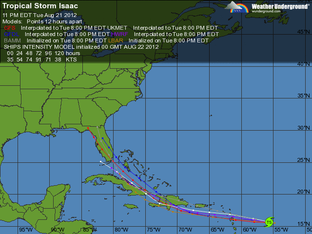
5 day tracking

edit on 21-8-2012 by MrWendal because: (no reason given)
reply to post by lasertaglover
So for the record, I can't stand either party...but, the GOP should be watching this storm lol, as their convention is in Tampa next week, and soon to be Hurricane Isaac might possibly visit them around the same time.
The forecast yesterday showed a Cat 2 hurricane by early next week, but today it is showing just a strong Cat 1. It will probably depend on how fast it crosses Cuba as to how strong it gets. The waters are very warm, so it has some potential to grow stronger.
Peace
At least Tropical Storm Joyce wont hit the US.
www.nhc.noaa.gov...
But I think the panhandle of Florida really needs to keep an eye on Isaac. The wind speed models only go through next Tuesday right now, but by next Tuesday he will be in some very warm water.
www.nhc.noaa.gov...
Peace
www.nhc.noaa.gov...
But I think the panhandle of Florida really needs to keep an eye on Isaac. The wind speed models only go through next Tuesday right now, but by next Tuesday he will be in some very warm water.
www.nhc.noaa.gov...
Peace
The current model on Isaac has it making landfall in the Florida Panhandle late Tuesday evening/ early morning Wednesday as a Cat 2 Hurricane.
My prediction: Based on what I am seeing, Tampa will be fine. It will stay just outside the storm. They may see some showers. I would be more worried if I was living around the Mobile, Alabama area. Expect high winds, lots and lots of rain which will probably result in some flooding.
My prediction: Based on what I am seeing, Tampa will be fine. It will stay just outside the storm. They may see some showers. I would be more worried if I was living around the Mobile, Alabama area. Expect high winds, lots and lots of rain which will probably result in some flooding.
We left Punta Gorda Fl. at 11:00 am yesterday and arrived here in Ohio late this evening. We were all set to do a 2 week vaca but left a week early
because of the potential threats. Just a few weeks back we lost power for 5 days because of the derecho and with three small dogs and as hot as it is
I am not a glutten for punishment.
I would just like to say to those who do live in the areas that could or will be affected - we took 75 N home and over the last 20 hours of drive time we saw over a 100 power company trucks and that number doesn't include tree trimmer trucks, such as asplundh and all were headed south.
Help is on the way.
edit on 25-8-2012 by Myrtales Instinct because: (no reason given)
reply to post by Myrtales Instinct
Yes, its not the wind speed of Isaac, its how far out the bands are extended. Glad you are safe.
www.nhc.noaa.gov...
Peace
Yes, its not the wind speed of Isaac, its how far out the bands are extended. Glad you are safe.
www.nhc.noaa.gov...
Peace
reply to post by MrWendal
Ha. I live on a barrier island directly south of Mobile, AL. So far, I am ambivalent. We see worse thundershowers than a Cat. 2. I haven't decided on the boarding up, but I am doing a quick check of the generator.
Why is it that they are having such issues with this storm? It is odd. All of the forecasts have the storm landing around Destin, FL, yet everyone I talk to says it is coming for us. Again, odd, I say.
reply to post by amarenell
The experts have been adjusting the storms track every single day, and every single day they are moving it to the West. Now even though the eye may make landfall in Destin, the storm will be large enough to reach into Mobile. With any Hurricane, it is not always WHERE it makes landfall as the dangers of the storm extend well away from the storm's center. When people discuss where a storm makes landfall, that is where the eye makes landfall, but as well all know the storm itself is happening well away from the eye.
Here is an example of the track adjustments being made.... this first pic is from several days ago. I think I posted it in this thread already, but look at the storm track. It shows Isaac making landfall right at the southern tip of Florida.

Now look at the latest track and see the difference.
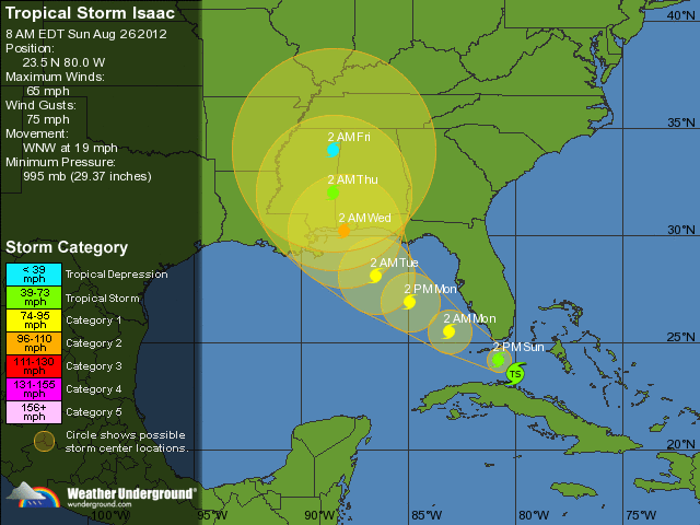
Now I may be a bit off, but the current track sure looks like a direct hit just East of Mobile.
Now the next thing to keep in mind, the waters in the Gulf are warm. We could easily see some strengthening once this storm enters the Gulf. As an example of how storms can change quickly, look at Katrina. Once Katrina passed land in Florida, it was downgraded to tropical storm status. It regained strength one hour after entering the Gulf of Mexico. The storm then went from a Cat 3 hurricane to a Cat 5 after reaching the warm waters of the Gulf.
Now going back to the latest track, and as I said the experts keep pushing it a little more west every day, this is the latest word from Weather Underground (whom I trust with my life in their hurricane predictions)
The next 48 hours are going to be really important in seeing where this storm will go. Here are some of the computer models to give you an idea of just how far west this storm could drift before making landfall.
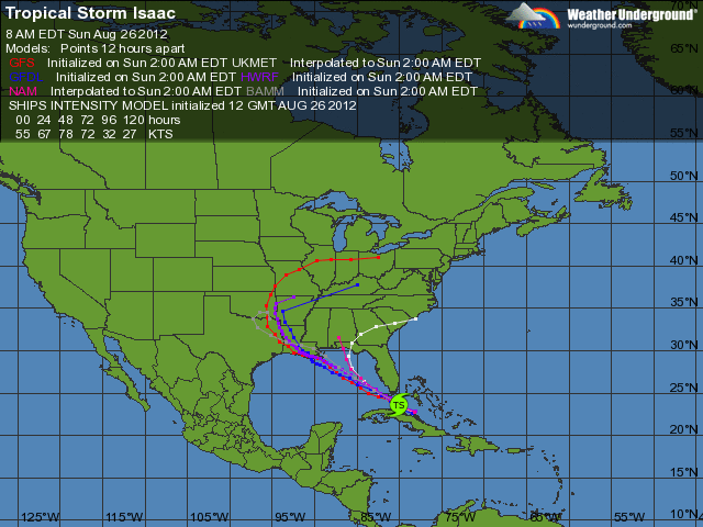
The experts have been adjusting the storms track every single day, and every single day they are moving it to the West. Now even though the eye may make landfall in Destin, the storm will be large enough to reach into Mobile. With any Hurricane, it is not always WHERE it makes landfall as the dangers of the storm extend well away from the storm's center. When people discuss where a storm makes landfall, that is where the eye makes landfall, but as well all know the storm itself is happening well away from the eye.
Here is an example of the track adjustments being made.... this first pic is from several days ago. I think I posted it in this thread already, but look at the storm track. It shows Isaac making landfall right at the southern tip of Florida.

Now look at the latest track and see the difference.

Now I may be a bit off, but the current track sure looks like a direct hit just East of Mobile.
Now the next thing to keep in mind, the waters in the Gulf are warm. We could easily see some strengthening once this storm enters the Gulf. As an example of how storms can change quickly, look at Katrina. Once Katrina passed land in Florida, it was downgraded to tropical storm status. It regained strength one hour after entering the Gulf of Mexico. The storm then went from a Cat 3 hurricane to a Cat 5 after reaching the warm waters of the Gulf.
Now going back to the latest track, and as I said the experts keep pushing it a little more west every day, this is the latest word from Weather Underground (whom I trust with my life in their hurricane predictions)
confidence in the long-range track forecast is quite low...and it is too early to determine exactly where and when Isaac will make landfall along the Gulf Coast. Further adjustments to the track may be necessary later today. Read more at www.wunderground.com...
The next 48 hours are going to be really important in seeing where this storm will go. Here are some of the computer models to give you an idea of just how far west this storm could drift before making landfall.

Tampa area here. Honestly, I'm disappointed, I was hoping it'd stick to skirting up the coast & give us a thrill. We're overdue for one anyway
Hopefully some of the storms in the feeder bands will do the trick & knock the power out for a day or two, as unlikely as that length is. I'd love to see the stars without light pollution for once!
Hopefully some of the storms in the feeder bands will do the trick & knock the power out for a day or two, as unlikely as that length is. I'd love to see the stars without light pollution for once!
New readings in on Isaac as of 2 hours ago.
The current tracking is showing land fall around the New Orleans area with the storm effecting the entire Louisiana Gulf Cost and and areas around the Texas boarder.
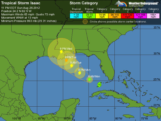
One thing I noticed... if you go back to my previous post showing the computer models, the most accurate model appears to be the HWRF model. Their model has shown very little change, and is currently showing landfall West of New Orleans and closer to the Louisiana/Texas boarder, which is actually where I live, so I guess I will have to find a place to store my motorcycle
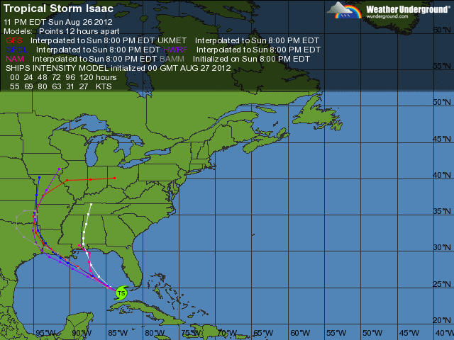
I think the speed of this storm will make a big difference, strengthening is expected, but there are other factors which could prevent any significant strengthening. From weather underground...
I am starting to the the HWFR model may have been the most accurate and this storm just may continue to travel farther west, and the report is that there is plenty of uncertainty in the current tracking.
The next 24 hours should tell give us a better idea of where Isaac is heading and just how strong it will be, and I think the actual speed of this storm will be a huge factor. If it moves slowly through the Gulf, it will have more time to strengthen over the warm water temps.
The current tracking is showing land fall around the New Orleans area with the storm effecting the entire Louisiana Gulf Cost and and areas around the Texas boarder.

One thing I noticed... if you go back to my previous post showing the computer models, the most accurate model appears to be the HWRF model. Their model has shown very little change, and is currently showing landfall West of New Orleans and closer to the Louisiana/Texas boarder, which is actually where I live, so I guess I will have to find a place to store my motorcycle

I think the speed of this storm will make a big difference, strengthening is expected, but there are other factors which could prevent any significant strengthening. From weather underground...
The large scale environmental factors...warm waters...and a conducive upper-air pattern favor strengthening during the next couple of days. However...the lack of an inner core and large wind field could continue to be impeding factors for significant strengthening in the short term. The NHC intensity forecast shows a gradual increase in wind speed during the next 12 hours or so...followed by more steady strengthening. The official forecast is close to the SHIPS/lgem guidance and the intensity consensus. Read more at www.wunderground.com...
I am starting to the the HWFR model may have been the most accurate and this storm just may continue to travel farther west, and the report is that there is plenty of uncertainty in the current tracking.
Because of the very large spread in the guidance...there continues to be greater than usual track forecast uncertainty. Read more at www.wunderground.com...
The next 24 hours should tell give us a better idea of where Isaac is heading and just how strong it will be, and I think the actual speed of this storm will be a huge factor. If it moves slowly through the Gulf, it will have more time to strengthen over the warm water temps.
You all realize, don't you, that Isaac is coming in almost 7 years to the day since Katrina?
odd
stay safe down there!
odd
stay safe down there!
Originally posted by berkeleygal
You all realize, don't you, that Isaac is coming in almost 7 years to the day since Katrina?
odd
Quite odd indeed.
Katrina was first upgraded to Tropical Storm status on August 24, 2005, and it was given its name. It only just make it to a category one hurricane before it crossed the coast of Florida early morning August 25. Katrina weakened over land and was below Hurricane intensity for a few hours. However, it quickly redeveloped into a hurricane when it entered the Gulf of Mexico. On the 27th of August, Hurricane Katrina hit category three and it actually reached category five intensity the next day. Fortunately, Katrina weakened a little before it hit the coast. In the early hours of August 28, Katrina hit the coast as a category three hurricane near Buras-Triumph, Louisiana. Katrina then went back over the sea for a few hours before it made its third and final cross over land as a hurricane near the Louisiana/Mississippi border. Hurricane Katrina maintained hurricane intensity well into Mississippi.
wanttoknowit.com...
Originally posted by berkeleygal
You all realize, don't you, that Isaac is coming in almost 7 years to the day since Katrina?
odd
stay safe down there!
Not that odd. This is an above-normal year for activity, and we're smack in the middle of the most active stretch of the season, which if memory serves, runs August 20th through September 11th or 12th. If I felt like sifting through the historical data, I'm positive I could find many storms making landfalls in the same general area around the same dates in different years, too.
The graphics here are only for major/infamous storms, but it helps prove my point a little. Notice which area landfall tended to be with them? Not that unusual.
www.accuweather.com...
edit on 8/27/2012 by Nyiah because: (no reason given)
Isaac will probably become a hurricane today. I'm not sure If I support rapid intensification to a Major (cat 3 or higher) but I do believe he will
be a strong Cat 1 at landfall possible a Cat 2 if he slows down more. As for where exactly he makes landfall, I have no guesses but know that the
affects will be far reaching. It's still raining and gusting occassionally here in South East Florida and we are many many miles away from Isaac's
center. I urge ALL Gulf Coast residents from Texax to Florida to be prepared. Prepare for the worst and hope for the best. We in South Florida are
feeling very fortunate that it was not worse for us.
new topics
-
Bin Cyber Junk…
Short Stories: 30 minutes ago -
The Undertones - Teenage Kicks
Music: 1 hours ago -
Volcano Watch 2025
Fragile Earth: 1 hours ago -
Judge rules president-elect Donald Trump must be sentenced in 'hush money' trial
US Political Madness: 9 hours ago -
Farmers wife
Music: 11 hours ago
top topics
-
New Jersey-Teachers Can Now Be Certified Without Passing Basic Reading Writing Math Testing
Education and Media: 15 hours ago, 8 flags -
NJ Drones tied to Tesla explosion at Trump Las vegas
General Conspiracies: 12 hours ago, 8 flags -
Judge rules president-elect Donald Trump must be sentenced in 'hush money' trial
US Political Madness: 9 hours ago, 3 flags -
Farmers wife
Music: 11 hours ago, 2 flags -
Volcano Watch 2025
Fragile Earth: 1 hours ago, 1 flags -
Bin Cyber Junk…
Short Stories: 30 minutes ago, 1 flags -
The Undertones - Teenage Kicks
Music: 1 hours ago, 0 flags
active topics
-
Petition Calling for General Election at 564,016 and rising Fast
Political Issues • 221 • : AdultMaleHumanUK -
Labour's Anti-Corruption Minister Named in Bangladesh Corruption Court Papers
Regional Politics • 7 • : gortex -
New Jersey-Teachers Can Now Be Certified Without Passing Basic Reading Writing Math Testing
Education and Media • 13 • : xuenchen -
Judge rules president-elect Donald Trump must be sentenced in 'hush money' trial
US Political Madness • 8 • : Boomer1947 -
Orbs Appear And Form Triangle On Live Cam.
Aliens and UFOs • 21 • : alldaylong -
NJ Drones tied to Tesla explosion at Trump Las vegas
General Conspiracies • 11 • : worldstarcountry -
Bin Cyber Junk…
Short Stories • 0 • : JJproductions -
Mood Music Part VI
Music • 3777 • : Skinnerbot -
Matthew Livelsberger said he was being followed by FBI
Political Conspiracies • 66 • : xuenchen -
Paranoid Liberals Believe U.S. Service Members are More Dangerous than Illegal Aliens.
Social Issues and Civil Unrest • 36 • : Lazy88
