It looks like you're using an Ad Blocker.
Please white-list or disable AboveTopSecret.com in your ad-blocking tool.
Thank you.
Some features of ATS will be disabled while you continue to use an ad-blocker.

Quake Watch 2012
page: 52share:
reply to post by PuterMan
Yeah I guess their theory is bollocks... so what's yours that would explain that?
Thanks
Hang on a minute. It reversed subduction? I always knew there was something wrong with that theory.
Yeah I guess their theory is bollocks... so what's yours that would explain that?
Thanks
reply to post by Vitchilo
Very quick answer based on loads of assumptions. IF the reason for Benioff zones is spherical lensing, which is caused by cooling and contraction then IF the lens area cools faster than the surrounding crust it will shrink and the 'side' of the lensed area will contract and thus there will be s very slight effect of moving upwards one against the other.
Of course that also may be complete cojones.
source(www.emsc-csem.org...
Magnitude M 5.8 Region KEPULAUAN KAI, INDONESIA
Date time 2012-02-22 10:45:22.2 UTC
Location 5.30 S ; 133.61 E
Depth 10 km
Distances 557 km SE Sorong (pop 125,535 ; local time 19:45:22.2 2012-02-22) 103 km E Tual (pop 39,502 ; local time 19:45:22.2 2012-02-22)
Source parameters not yet reviewed by a seismologist
edit on 22-2-2012 by diamondsmith because: add
reply to post by ButterCookie
I think I would have to agree with you there. Thing is one needs to report what is being said by the experts, however far fetched or daft it may sound, so that we have all the information to make a decision for ourselves.
Now whether they actually mean that, or perhaps were just saying that these quakes are the crust settling after th1812 quakes and thus COULD be called aftershocks, I am not sure but they certainly do not fit what I understand to be the definition of aftershocks. Quakes that are within a certain radius (depends on the main shock magnitude) that are over and above the number of quakes that are normal for the area, in other words all increased activity until normal levels are resumed.
I'm not so sure that every time the New Madrid Fault has a quake that it is an aftershock to the quake of 1812....
I think I would have to agree with you there. Thing is one needs to report what is being said by the experts, however far fetched or daft it may sound, so that we have all the information to make a decision for ourselves.
Now whether they actually mean that, or perhaps were just saying that these quakes are the crust settling after th1812 quakes and thus COULD be called aftershocks, I am not sure but they certainly do not fit what I understand to be the definition of aftershocks. Quakes that are within a certain radius (depends on the main shock magnitude) that are over and above the number of quakes that are normal for the area, in other words all increased activity until normal levels are resumed.
As I suspected, the minute this quake hit the 8 to 30 day listing today it was downgraded to 5.8. This
despite the fact that PNSN has it as two which I agree with, 1 x 6.0 and 1 x 5.9
Left hand and right hand? :shk:
Here is a pic of it for you. By the way the reason there are no links is because it is still in limbo land and has not got it's NEIC ID yet. (It may have by the time you look at the listing on the web)
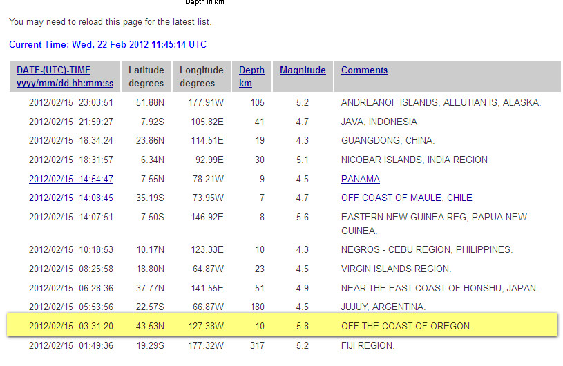
2012/02/15 03:31:20 43.53N 127.38W 10 5.8 OFF THE COAST OF OREGON.
Left hand and right hand? :shk:
Here is a pic of it for you. By the way the reason there are no links is because it is still in limbo land and has not got it's NEIC ID yet. (It may have by the time you look at the listing on the web)
edit on 22/2/2012 by PuterMan because: (no reason given)
Anybody notice that 3.4 in Virginia?
I,ve had my eye on the New Madrid and east coast all nite. I look away for a minute and boo!! Any one feel that?
I,ve had my eye on the New Madrid and east coast all nite. I look away for a minute and boo!! Any one feel that?
reply to post by crappiekat
I don't post on this thread but I am active on another earthquake thread and just posted the link on that thread, but yeah I just saw that on my twitter feed.
I don't post on this thread but I am active on another earthquake thread and just posted the link on that thread, but yeah I just saw that on my twitter feed.
Originally posted by crappiekat
Anybody notice that 3.4 in Virginia?
I,ve had my eye on the New Madrid and east coast all nite. I look away for a minute and boo!! Any one feel that?
didnt notice the VA earthquake until i saw the new Madrid on..thought i was loosing my mind..lol..yep its heating up..
Originally posted by crappiekat
Anybody notice that 3.4 in Virginia?
I,ve had my eye on the New Madrid and east coast all nite. I look away for a minute and boo!! Any one feel that?
Got a link because I have not seen any evidence that suggests they just had one??
Thanks!
reply to post by MamaJ
I saw it!
Type: Earthquake
91 minutes ago
Magnitude: 3.4
DateTime: Wednesday February 22 2012, 12:49:57 UTC
Region: West Virginia
Depth: 5 km
Source: USGS Feed
Global Quakes
It still shows there, but I first spotted it on usgs.gov. Don't know where it went.
I saw it!
Type: Earthquake
91 minutes ago
Magnitude: 3.4
DateTime: Wednesday February 22 2012, 12:49:57 UTC
Region: West Virginia
Depth: 5 km
Source: USGS Feed
Global Quakes
It still shows there, but I first spotted it on usgs.gov. Don't know where it went.
Originally posted by Doodle19815
reply to post by MamaJ
I saw it!
Type: Earthquake
91 minutes ago
Magnitude: 3.4
DateTime: Wednesday February 22 2012, 12:49:57 UTC
Region: West Virginia
Depth: 5 km
Source: USGS Feed
Global Quakes
It still shows there, but I first spotted it on usgs.gov. Don't know where it went.
Thats craaaazy!
I see it on the global site and I see where it says they got their feed from USGS but there is notta on USGS regarding West Virginia. WTH??
I see all over the internet links of local news talking about Boone County waking up to a 3.4. I even had links to USGS and other sites with the info
from USGS on it...but no sign of it on USGS anymore. The links to USGS regarding the quake is broken now. Hmmmmmm.... maybe it wasn't a quake or
maybe they want to trick us.
reply to post by MamaJ
The weird thing is they had 4 people reporting to the felt it page shortly after it happened. (I saw it about 15 minutes after it happened). Sooooo......something must have rumbled them, right?
The weird thing is they had 4 people reporting to the felt it page shortly after it happened. (I saw it about 15 minutes after it happened). Sooooo......something must have rumbled them, right?
Haha, they can't fool us that easily!
reply to post by MamaJ
E.T.A. Felt it responses, I am a little curious about the report from ST. LOUIS?????
Summary of Responses by Zip
VA Springfield 22153 2 1 388 38.75°N 77.23°W
VA Charlottesville 22903 2 1 259 38.02°N 78.60°W
VA Charlottesville 22911 2 1 276 38.09°N 78.41°W
VA Vinton 24179 2 1 171 37.28°N 79.79°W
MO Saint Louis 63127 2 1 778 38.54°N 90.41°W
edit on 22-2-2012 by Doodle19815 because: (no reason given)
reply to post by Doodle19815
Ha! WTH is going on I wonder. I see it all over the place except on USGS where it originated from. If the locals felt it and the local news is reporting it happened then I wonder why they took it off their feed.
Yesterday was the New Moon so I was wondering if we will have a bigger one somewhere today...but I seriously hope we don't and if we do....release the pressure in the sea far from land is my hope.
reply to post by Doodle19815
E.T.A. Felt it responses, I am a little curious about the report from ST. LOUIS????? Summary of Responses by Zip
St. Louis??? WHOA! Hmmm....
That makes one wonder doesn't it. How could they have possibly felt it that far away?? I knew they were connected but...not like that and that far. Thats just crazy!
reply to post by Doodle19815
[mor
St Louis report of tremor:
63127 is an area directly west of the earthquake (and many many miles away). This is according to google maps.
Depending on geology, maybe they felt it. I know I rarely feel the "usual" quakes but the fracking quakes due south of me gave me and my house problems. Guy, Arkansas quakes really got to me.
Does anyone know which network to add to Gee to get a closer look? Or where I could find that information for myself?
reply to
post by sageturkey
Try this
Or this
That is the best I can do for you. Still learning this stuff.
post by sageturkey
Try this
Or this
That is the best I can do for you. Still learning this stuff.
reply to post by Doodle19815
Thanks Doodle, me too. Still having a hard time getting the Gee real-time viewer to not display such large waveforms, the links you provided will help in the mean-time. Meanwhile, watching the swarm at Kilauea progress. 19 so far today and counting
Thanks Doodle, me too. Still having a hard time getting the Gee real-time viewer to not display such large waveforms, the links you provided will help in the mean-time. Meanwhile, watching the swarm at Kilauea progress. 19 so far today and counting
new topics
-
Search to Resume for MH 370
Disaster Conspiracies: 1 hours ago -
Sue Gray, Sir Keir Starmer's former Chief of Staff, Nominated for Peerage
Regional Politics: 3 hours ago -
Biden Nationalizes Another 50,000+ Student Loans as He Heads for the Exit
US Political Madness: 4 hours ago
top topics
-
An Interesting Conversation with ChatGPT
Science & Technology: 13 hours ago, 7 flags -
Biden Nationalizes Another 50,000+ Student Loans as He Heads for the Exit
US Political Madness: 4 hours ago, 6 flags -
Sue Gray, Sir Keir Starmer's former Chief of Staff, Nominated for Peerage
Regional Politics: 3 hours ago, 2 flags -
Search to Resume for MH 370
Disaster Conspiracies: 1 hours ago, 2 flags
active topics
-
Biden Nationalizes Another 50,000+ Student Loans as He Heads for the Exit
US Political Madness • 3 • : Flyingclaydisk -
Search to Resume for MH 370
Disaster Conspiracies • 2 • : Flyingclaydisk -
Can someone 'splain me like I'm 5. Blockchain?
Science & Technology • 88 • : Flyingclaydisk -
Russias War Against Religion in Ukraine
World War Three • 53 • : Oldcarpy2 -
-@TH3WH17ERABB17- -Q- ---TIME TO SHOW THE WORLD--- -Part- --44--
Dissecting Disinformation • 3765 • : Thoughtful3 -
An Interesting Conversation with ChatGPT
Science & Technology • 20 • : randomuser2034 -
US Federal Funding set to Expire December 20th. Massive CR on the way.
Mainstream News • 42 • : marg6043 -
Squirrels becoming predators
Fragile Earth • 33 • : Oldcarpy2 -
Why isn't Psychiatry involved?
Social Issues and Civil Unrest • 26 • : lilzazz -
Mood Music Part VI
Music • 3748 • : ChaoticOrder